


EverydayHiker
@everydayhiker.bsky.social
Former fisheries scientist, current everyday hiker. Join me on the trail with daily photos of the hikes I’ve done. HQ photos at flickr.com/everydayhiker/
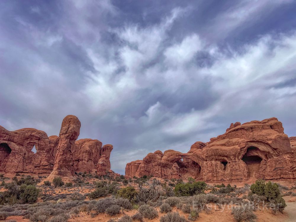
Chesler Park Loop
Canyonlands National Park- The Needles District, Utah
Hard, 10.4 mi loop
1,801 ft elevation gain
Hiked 12/20/23
Flickr Album flic.kr/s/aHBqjCD3RK
#Canyonlands #NationalParks #Utah #hiking #photography #landscape #wildlife
Canyonlands National Park- The Needles District, Utah
Hard, 10.4 mi loop
1,801 ft elevation gain
Hiked 12/20/23
Flickr Album flic.kr/s/aHBqjCD3RK
#Canyonlands #NationalParks #Utah #hiking #photography #landscape #wildlife


December 8, 2025 at 12:47 AM
Chesler Park Loop
Canyonlands National Park- The Needles District, Utah
Hard, 10.4 mi loop
1,801 ft elevation gain
Hiked 12/20/23
Flickr Album flic.kr/s/aHBqjCD3RK
#Canyonlands #NationalParks #Utah #hiking #photography #landscape #wildlife
Canyonlands National Park- The Needles District, Utah
Hard, 10.4 mi loop
1,801 ft elevation gain
Hiked 12/20/23
Flickr Album flic.kr/s/aHBqjCD3RK
#Canyonlands #NationalParks #Utah #hiking #photography #landscape #wildlife
Elephant Hill Trail
Canyonlands National Park-The Needles, Utah
Easy to Moderate, 2.6 mi out and back
456 ft elevation gain
Hiked 12/19/23 (sunrise the next morning part of larger hike)
Flickr Album flic.kr/s/aHBqjCCRDf
#Canyonlands #Utah #sunrise #hiking #photography #Landscape #NationalParks
Canyonlands National Park-The Needles, Utah
Easy to Moderate, 2.6 mi out and back
456 ft elevation gain
Hiked 12/19/23 (sunrise the next morning part of larger hike)
Flickr Album flic.kr/s/aHBqjCCRDf
#Canyonlands #Utah #sunrise #hiking #photography #Landscape #NationalParks


December 5, 2025 at 8:06 PM
Elephant Hill Trail
Canyonlands National Park-The Needles, Utah
Easy to Moderate, 2.6 mi out and back
456 ft elevation gain
Hiked 12/19/23 (sunrise the next morning part of larger hike)
Flickr Album flic.kr/s/aHBqjCCRDf
#Canyonlands #Utah #sunrise #hiking #photography #Landscape #NationalParks
Canyonlands National Park-The Needles, Utah
Easy to Moderate, 2.6 mi out and back
456 ft elevation gain
Hiked 12/19/23 (sunrise the next morning part of larger hike)
Flickr Album flic.kr/s/aHBqjCCRDf
#Canyonlands #Utah #sunrise #hiking #photography #Landscape #NationalParks
Cave Springs Trail
Canyonlands National Park- Needles District, Utah
Easy, 0.74 ft loop
82 ft elevation gain, no gain if only viewing historic sites
Hiked 12/19/23
Flickr Album flic.kr/s/aHBqjCCTNY
#Canyonlands #NationalParks #Utah #HistoricSites #hiking #photography
Canyonlands National Park- Needles District, Utah
Easy, 0.74 ft loop
82 ft elevation gain, no gain if only viewing historic sites
Hiked 12/19/23
Flickr Album flic.kr/s/aHBqjCCTNY
#Canyonlands #NationalParks #Utah #HistoricSites #hiking #photography


December 4, 2025 at 8:01 PM
Cave Springs Trail
Canyonlands National Park- Needles District, Utah
Easy, 0.74 ft loop
82 ft elevation gain, no gain if only viewing historic sites
Hiked 12/19/23
Flickr Album flic.kr/s/aHBqjCCTNY
#Canyonlands #NationalParks #Utah #HistoricSites #hiking #photography
Canyonlands National Park- Needles District, Utah
Easy, 0.74 ft loop
82 ft elevation gain, no gain if only viewing historic sites
Hiked 12/19/23
Flickr Album flic.kr/s/aHBqjCCTNY
#Canyonlands #NationalParks #Utah #HistoricSites #hiking #photography
Newspaper Rock
Bears Ears National Monument, Utah
Easy, 0.1 mi out and back
20 ft elevation gain
Hiked 9/19/23
Flickr Album flic.kr/s/aHBqjCCBLi
en.wikipedia.org/wiki/Newspap...
#Petroglyphs #BearsEars #Utah #Archaeological #FirstPeoples
Bears Ears National Monument, Utah
Easy, 0.1 mi out and back
20 ft elevation gain
Hiked 9/19/23
Flickr Album flic.kr/s/aHBqjCCBLi
en.wikipedia.org/wiki/Newspap...
#Petroglyphs #BearsEars #Utah #Archaeological #FirstPeoples


December 3, 2025 at 8:06 PM
Newspaper Rock
Bears Ears National Monument, Utah
Easy, 0.1 mi out and back
20 ft elevation gain
Hiked 9/19/23
Flickr Album flic.kr/s/aHBqjCCBLi
en.wikipedia.org/wiki/Newspap...
#Petroglyphs #BearsEars #Utah #Archaeological #FirstPeoples
Bears Ears National Monument, Utah
Easy, 0.1 mi out and back
20 ft elevation gain
Hiked 9/19/23
Flickr Album flic.kr/s/aHBqjCCBLi
en.wikipedia.org/wiki/Newspap...
#Petroglyphs #BearsEars #Utah #Archaeological #FirstPeoples
Landscape Arch, Double O Arch Trail
Arches National Park, Utah
Moderate, 6.08 mi Out and back with spurs
May be shortened to easy if stopping at Landscape Arch
919 ft elevation gain
Hiked 12/19/23
Flickr Album flic.kr/s/aHBqjCCv2w
#Arches #NationalParks #LandscapeArch #Utah #hiking #photography
Arches National Park, Utah
Moderate, 6.08 mi Out and back with spurs
May be shortened to easy if stopping at Landscape Arch
919 ft elevation gain
Hiked 12/19/23
Flickr Album flic.kr/s/aHBqjCCv2w
#Arches #NationalParks #LandscapeArch #Utah #hiking #photography


December 2, 2025 at 6:21 PM
Landscape Arch, Double O Arch Trail
Arches National Park, Utah
Moderate, 6.08 mi Out and back with spurs
May be shortened to easy if stopping at Landscape Arch
919 ft elevation gain
Hiked 12/19/23
Flickr Album flic.kr/s/aHBqjCCv2w
#Arches #NationalParks #LandscapeArch #Utah #hiking #photography
Arches National Park, Utah
Moderate, 6.08 mi Out and back with spurs
May be shortened to easy if stopping at Landscape Arch
919 ft elevation gain
Hiked 12/19/23
Flickr Album flic.kr/s/aHBqjCCv2w
#Arches #NationalParks #LandscapeArch #Utah #hiking #photography
Delicate Arch and Wolfe Ranch/Petroglyph Spur Trail
Arches National Park, Utah
Moderate, 4.3 mi out and back
663 ft elevation gain
Hiked 12/18/23
Flickr Album flic.kr/s/aHBqjCCyKC
#Arches #NationalParks #Utah #Petroglyphs #DelicateArch #Sunset #hiking #photography #landscape
Arches National Park, Utah
Moderate, 4.3 mi out and back
663 ft elevation gain
Hiked 12/18/23
Flickr Album flic.kr/s/aHBqjCCyKC
#Arches #NationalParks #Utah #Petroglyphs #DelicateArch #Sunset #hiking #photography #landscape


December 1, 2025 at 5:15 PM
Delicate Arch and Wolfe Ranch/Petroglyph Spur Trail
Arches National Park, Utah
Moderate, 4.3 mi out and back
663 ft elevation gain
Hiked 12/18/23
Flickr Album flic.kr/s/aHBqjCCyKC
#Arches #NationalParks #Utah #Petroglyphs #DelicateArch #Sunset #hiking #photography #landscape
Arches National Park, Utah
Moderate, 4.3 mi out and back
663 ft elevation gain
Hiked 12/18/23
Flickr Album flic.kr/s/aHBqjCCyKC
#Arches #NationalParks #Utah #Petroglyphs #DelicateArch #Sunset #hiking #photography #landscape
Double Arch Trail
Arches National Park, Utah
Easy, 0.6 mi out and back
75 ft elevation gain (less to viewpoint, more can be scrambled)
Hiked 12/18/23
Flickr Album flic.kr/s/aHBqjCCqFF
#Arches #NationalParks #DoubleArch #Hiking #Photography #Landscape #Utah
Arches National Park, Utah
Easy, 0.6 mi out and back
75 ft elevation gain (less to viewpoint, more can be scrambled)
Hiked 12/18/23
Flickr Album flic.kr/s/aHBqjCCqFF
#Arches #NationalParks #DoubleArch #Hiking #Photography #Landscape #Utah


December 1, 2025 at 12:04 AM
Double Arch Trail
Arches National Park, Utah
Easy, 0.6 mi out and back
75 ft elevation gain (less to viewpoint, more can be scrambled)
Hiked 12/18/23
Flickr Album flic.kr/s/aHBqjCCqFF
#Arches #NationalParks #DoubleArch #Hiking #Photography #Landscape #Utah
Arches National Park, Utah
Easy, 0.6 mi out and back
75 ft elevation gain (less to viewpoint, more can be scrambled)
Hiked 12/18/23
Flickr Album flic.kr/s/aHBqjCCqFF
#Arches #NationalParks #DoubleArch #Hiking #Photography #Landscape #Utah
Park Avenue Trail
Arches National Park, Utah
Easy, 2.0 mi out and back
338 ft elevation gain
Hiked 12/18/23
Flickr Album flic.kr/s/aHBqjCCcgG
#Arches #NationalParks #ParkAvenue #Sunbow #Landscape #photography #hiking #Utah
Arches National Park, Utah
Easy, 2.0 mi out and back
338 ft elevation gain
Hiked 12/18/23
Flickr Album flic.kr/s/aHBqjCCcgG
#Arches #NationalParks #ParkAvenue #Sunbow #Landscape #photography #hiking #Utah


November 29, 2025 at 6:10 PM
Park Avenue Trail
Arches National Park, Utah
Easy, 2.0 mi out and back
338 ft elevation gain
Hiked 12/18/23
Flickr Album flic.kr/s/aHBqjCCcgG
#Arches #NationalParks #ParkAvenue #Sunbow #Landscape #photography #hiking #Utah
Arches National Park, Utah
Easy, 2.0 mi out and back
338 ft elevation gain
Hiked 12/18/23
Flickr Album flic.kr/s/aHBqjCCcgG
#Arches #NationalParks #ParkAvenue #Sunbow #Landscape #photography #hiking #Utah
Balanced Rock Loop Trail
Arches National Park, Utah
Easy, 0.3 mi loop
45 ft elevation gain
Hiked 12/18/23
Flickr Album flic.kr/s/aHBqjCChR3
#Arches #NationalParks #Utah #BalancedRock #Hiking #Photography #Sunbow #landscape
Arches National Park, Utah
Easy, 0.3 mi loop
45 ft elevation gain
Hiked 12/18/23
Flickr Album flic.kr/s/aHBqjCChR3
#Arches #NationalParks #Utah #BalancedRock #Hiking #Photography #Sunbow #landscape


November 28, 2025 at 7:40 PM
Balanced Rock Loop Trail
Arches National Park, Utah
Easy, 0.3 mi loop
45 ft elevation gain
Hiked 12/18/23
Flickr Album flic.kr/s/aHBqjCChR3
#Arches #NationalParks #Utah #BalancedRock #Hiking #Photography #Sunbow #landscape
Arches National Park, Utah
Easy, 0.3 mi loop
45 ft elevation gain
Hiked 12/18/23
Flickr Album flic.kr/s/aHBqjCChR3
#Arches #NationalParks #Utah #BalancedRock #Hiking #Photography #Sunbow #landscape
Windows Loop and Turret Arch Trail
Arches National Park, Utah
Easy, 1.64 mi loop trail
348 ft elevation gain
Hiked 12/18/23
Flickr Album flic.kr/s/aHBqjCBXtc
#Arches #NationalParks #Sunrise #hiking #photography #landscape #Utah
Arches National Park, Utah
Easy, 1.64 mi loop trail
348 ft elevation gain
Hiked 12/18/23
Flickr Album flic.kr/s/aHBqjCBXtc
#Arches #NationalParks #Sunrise #hiking #photography #landscape #Utah


November 26, 2025 at 7:19 PM
Windows Loop and Turret Arch Trail
Arches National Park, Utah
Easy, 1.64 mi loop trail
348 ft elevation gain
Hiked 12/18/23
Flickr Album flic.kr/s/aHBqjCBXtc
#Arches #NationalParks #Sunrise #hiking #photography #landscape #Utah
Arches National Park, Utah
Easy, 1.64 mi loop trail
348 ft elevation gain
Hiked 12/18/23
Flickr Album flic.kr/s/aHBqjCBXtc
#Arches #NationalParks #Sunrise #hiking #photography #landscape #Utah
Shoshone Falls
Twin Falls, Idaho
A few viewpoints with minimal hiking
Minimal Elevation
Visited 12/16/23
#ShoshoneFalls #TwinFalls #Idaho #Waterfalls
Twin Falls, Idaho
A few viewpoints with minimal hiking
Minimal Elevation
Visited 12/16/23
#ShoshoneFalls #TwinFalls #Idaho #Waterfalls


November 25, 2025 at 7:33 PM
Shoshone Falls
Twin Falls, Idaho
A few viewpoints with minimal hiking
Minimal Elevation
Visited 12/16/23
#ShoshoneFalls #TwinFalls #Idaho #Waterfalls
Twin Falls, Idaho
A few viewpoints with minimal hiking
Minimal Elevation
Visited 12/16/23
#ShoshoneFalls #TwinFalls #Idaho #Waterfalls
Niagara Springs
Wendell, ID
No hike; short drive on a somewhat rough (iirc) gravel road
Visited 12/16/23
#NiagaraSprings #Waterfalls #GroundSprings #Idaho
Wendell, ID
No hike; short drive on a somewhat rough (iirc) gravel road
Visited 12/16/23
#NiagaraSprings #Waterfalls #GroundSprings #Idaho


November 24, 2025 at 4:53 PM
Niagara Springs
Wendell, ID
No hike; short drive on a somewhat rough (iirc) gravel road
Visited 12/16/23
#NiagaraSprings #Waterfalls #GroundSprings #Idaho
Wendell, ID
No hike; short drive on a somewhat rough (iirc) gravel road
Visited 12/16/23
#NiagaraSprings #Waterfalls #GroundSprings #Idaho
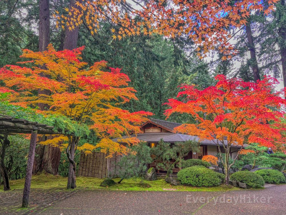
Portland Japanese Gardens
Portland, Oregon
Nature Walk, ~1 mi or less to see it all
Minimal elevation gain
'Hiked' 11/2/2023
Flickr Album flic.kr/s/aHBqjCBxs5
#Portland #Oregon #JapaneseGarden #Autumn #FallColors #JapaneseMaple
Portland, Oregon
Nature Walk, ~1 mi or less to see it all
Minimal elevation gain
'Hiked' 11/2/2023
Flickr Album flic.kr/s/aHBqjCBxs5
#Portland #Oregon #JapaneseGarden #Autumn #FallColors #JapaneseMaple


November 22, 2025 at 7:33 PM
Portland Japanese Gardens
Portland, Oregon
Nature Walk, ~1 mi or less to see it all
Minimal elevation gain
'Hiked' 11/2/2023
Flickr Album flic.kr/s/aHBqjCBxs5
#Portland #Oregon #JapaneseGarden #Autumn #FallColors #JapaneseMaple
Portland, Oregon
Nature Walk, ~1 mi or less to see it all
Minimal elevation gain
'Hiked' 11/2/2023
Flickr Album flic.kr/s/aHBqjCBxs5
#Portland #Oregon #JapaneseGarden #Autumn #FallColors #JapaneseMaple
Hurricane Hill via Hurricane Ridge
Olympic National Park, WA
Moderate, 4.35 mi out and back
883 ft elevation gain
Hiked 9/9/23
Flickr Album flic.kr/s/aHBqjCBtvo
#HurricaneHill #Olympic #NationalParks #PortAngeles #Wildfire #hiking #photography
Olympic National Park, WA
Moderate, 4.35 mi out and back
883 ft elevation gain
Hiked 9/9/23
Flickr Album flic.kr/s/aHBqjCBtvo
#HurricaneHill #Olympic #NationalParks #PortAngeles #Wildfire #hiking #photography


November 21, 2025 at 6:29 PM
Hurricane Hill via Hurricane Ridge
Olympic National Park, WA
Moderate, 4.35 mi out and back
883 ft elevation gain
Hiked 9/9/23
Flickr Album flic.kr/s/aHBqjCBtvo
#HurricaneHill #Olympic #NationalParks #PortAngeles #Wildfire #hiking #photography
Olympic National Park, WA
Moderate, 4.35 mi out and back
883 ft elevation gain
Hiked 9/9/23
Flickr Album flic.kr/s/aHBqjCBtvo
#HurricaneHill #Olympic #NationalParks #PortAngeles #Wildfire #hiking #photography
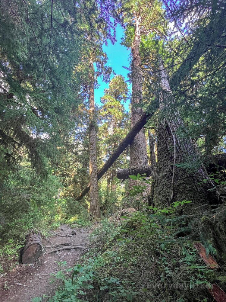
Heart O' the Forest Trail
Olympic National Park, WA
Easy to Moderate, 4.51 mi out and back
817 ft elevation gain
Hiked 9/8/25
Flickr Album flic.kr/s/aHBqjCBozS
#Olympic #NationalParks #Washington #Mushrooms #Hiking #Photography
Olympic National Park, WA
Easy to Moderate, 4.51 mi out and back
817 ft elevation gain
Hiked 9/8/25
Flickr Album flic.kr/s/aHBqjCBozS
#Olympic #NationalParks #Washington #Mushrooms #Hiking #Photography


November 20, 2025 at 8:16 PM
Heart O' the Forest Trail
Olympic National Park, WA
Easy to Moderate, 4.51 mi out and back
817 ft elevation gain
Hiked 9/8/25
Flickr Album flic.kr/s/aHBqjCBozS
#Olympic #NationalParks #Washington #Mushrooms #Hiking #Photography
Olympic National Park, WA
Easy to Moderate, 4.51 mi out and back
817 ft elevation gain
Hiked 9/8/25
Flickr Album flic.kr/s/aHBqjCBozS
#Olympic #NationalParks #Washington #Mushrooms #Hiking #Photography
High Divide and Seven Lakes Basin Trail
Olympic National Park, WA
Hard, 19.04 mi loop
4,911 ft elevation gain
Hiked 9/7/23
Flickr Album flic.kr/s/aHBqjCBrgG
#Olympic #NationalParks #HighDivide #SolDuc #Hiking #photography #Landscape#PNW #Washington
Olympic National Park, WA
Hard, 19.04 mi loop
4,911 ft elevation gain
Hiked 9/7/23
Flickr Album flic.kr/s/aHBqjCBrgG
#Olympic #NationalParks #HighDivide #SolDuc #Hiking #photography #Landscape#PNW #Washington


November 19, 2025 at 7:38 PM
High Divide and Seven Lakes Basin Trail
Olympic National Park, WA
Hard, 19.04 mi loop
4,911 ft elevation gain
Hiked 9/7/23
Flickr Album flic.kr/s/aHBqjCBrgG
#Olympic #NationalParks #HighDivide #SolDuc #Hiking #photography #Landscape#PNW #Washington
Olympic National Park, WA
Hard, 19.04 mi loop
4,911 ft elevation gain
Hiked 9/7/23
Flickr Album flic.kr/s/aHBqjCBrgG
#Olympic #NationalParks #HighDivide #SolDuc #Hiking #photography #Landscape#PNW #Washington
Marymere Falls Trail
Olympic National Park, Washington
Easy, 2.5 mi out and back
384 ft elevation gain
Hiked 9/16/25
Flickr Album flic.kr/s/aHBqjCBaAr
#Olympic #NationalParks #Waterfalls #Washington #Hiking #photography #OldGrowth
Olympic National Park, Washington
Easy, 2.5 mi out and back
384 ft elevation gain
Hiked 9/16/25
Flickr Album flic.kr/s/aHBqjCBaAr
#Olympic #NationalParks #Waterfalls #Washington #Hiking #photography #OldGrowth


November 18, 2025 at 7:02 PM
Marymere Falls Trail
Olympic National Park, Washington
Easy, 2.5 mi out and back
384 ft elevation gain
Hiked 9/16/25
Flickr Album flic.kr/s/aHBqjCBaAr
#Olympic #NationalParks #Waterfalls #Washington #Hiking #photography #OldGrowth
Olympic National Park, Washington
Easy, 2.5 mi out and back
384 ft elevation gain
Hiked 9/16/25
Flickr Album flic.kr/s/aHBqjCBaAr
#Olympic #NationalParks #Waterfalls #Washington #Hiking #photography #OldGrowth
5-Mile Island via Hoh River Trail
Olympic National Park, Washington
Moderate, 10.59 mi out and back
860 ft elevation gain
Hiked 9/5/23
Flickr Album flic.kr/s/aHBqjCB29j
#HohRainforest #HohRiver #OlympicNationalPark #NationalParks #hiking #photography #Washington #PNW
Olympic National Park, Washington
Moderate, 10.59 mi out and back
860 ft elevation gain
Hiked 9/5/23
Flickr Album flic.kr/s/aHBqjCB29j
#HohRainforest #HohRiver #OlympicNationalPark #NationalParks #hiking #photography #Washington #PNW


November 17, 2025 at 5:47 PM
5-Mile Island via Hoh River Trail
Olympic National Park, Washington
Moderate, 10.59 mi out and back
860 ft elevation gain
Hiked 9/5/23
Flickr Album flic.kr/s/aHBqjCB29j
#HohRainforest #HohRiver #OlympicNationalPark #NationalParks #hiking #photography #Washington #PNW
Olympic National Park, Washington
Moderate, 10.59 mi out and back
860 ft elevation gain
Hiked 9/5/23
Flickr Album flic.kr/s/aHBqjCB29j
#HohRainforest #HohRiver #OlympicNationalPark #NationalParks #hiking #photography #Washington #PNW
Quinault Big Sitka Spruce Tree Trail
Quinault, Washington
Easy, 0.42 mi out and back
36 ft elevation gain
Hiked 9/5/23
Flickr Album flic.kr/s/aHBqjCAJ1c
#WorldsTallest #SitkaSpruce #TallTrees #Washington #QuinaultRainforest #hiking #Photography
Quinault, Washington
Easy, 0.42 mi out and back
36 ft elevation gain
Hiked 9/5/23
Flickr Album flic.kr/s/aHBqjCAJ1c
#WorldsTallest #SitkaSpruce #TallTrees #Washington #QuinaultRainforest #hiking #Photography


November 14, 2025 at 7:11 PM
Quinault Big Sitka Spruce Tree Trail
Quinault, Washington
Easy, 0.42 mi out and back
36 ft elevation gain
Hiked 9/5/23
Flickr Album flic.kr/s/aHBqjCAJ1c
#WorldsTallest #SitkaSpruce #TallTrees #Washington #QuinaultRainforest #hiking #Photography
Quinault, Washington
Easy, 0.42 mi out and back
36 ft elevation gain
Hiked 9/5/23
Flickr Album flic.kr/s/aHBqjCAJ1c
#WorldsTallest #SitkaSpruce #TallTrees #Washington #QuinaultRainforest #hiking #Photography
Mt Trinity area walkabout
Lovelock, NV
Moderate, 4.53 mi out and back/wander
1,089 ft elevation gain
Hiked 11/2/24
#Rockhounding #Nevada #TrinityMountains #Desert #Hiking #photography
Lovelock, NV
Moderate, 4.53 mi out and back/wander
1,089 ft elevation gain
Hiked 11/2/24
#Rockhounding #Nevada #TrinityMountains #Desert #Hiking #photography


November 13, 2025 at 7:02 PM
Mt Trinity area walkabout
Lovelock, NV
Moderate, 4.53 mi out and back/wander
1,089 ft elevation gain
Hiked 11/2/24
#Rockhounding #Nevada #TrinityMountains #Desert #Hiking #photography
Lovelock, NV
Moderate, 4.53 mi out and back/wander
1,089 ft elevation gain
Hiked 11/2/24
#Rockhounding #Nevada #TrinityMountains #Desert #Hiking #photography
North Dome and Indian Arch
Yosemite National Park, California
Moderate to Hard, 9.84 mi out and back
2,188 ft elevation gain
Hiked 10/26/24
Flickr Album flic.kr/s/aHBqjCAu7f
#Yosemite #NorthDome #HalfDome #IndianArch #NationalParks #Landscape #photography #hiking
Yosemite National Park, California
Moderate to Hard, 9.84 mi out and back
2,188 ft elevation gain
Hiked 10/26/24
Flickr Album flic.kr/s/aHBqjCAu7f
#Yosemite #NorthDome #HalfDome #IndianArch #NationalParks #Landscape #photography #hiking


November 12, 2025 at 7:40 PM
North Dome and Indian Arch
Yosemite National Park, California
Moderate to Hard, 9.84 mi out and back
2,188 ft elevation gain
Hiked 10/26/24
Flickr Album flic.kr/s/aHBqjCAu7f
#Yosemite #NorthDome #HalfDome #IndianArch #NationalParks #Landscape #photography #hiking
Yosemite National Park, California
Moderate to Hard, 9.84 mi out and back
2,188 ft elevation gain
Hiked 10/26/24
Flickr Album flic.kr/s/aHBqjCAu7f
#Yosemite #NorthDome #HalfDome #IndianArch #NationalParks #Landscape #photography #hiking
Obsidian Dome Trail
Inyo National Forest, Crestview, CA
Easy, 1.33 mi loop
223 ft elevation gain
Hiked 10/19/25
Flickr Album flic.kr/s/aHBqjCAt3d
#ObsidianDome #Obsidian #Volcano #Inyo #California #hiking #Sierra #photography
Inyo National Forest, Crestview, CA
Easy, 1.33 mi loop
223 ft elevation gain
Hiked 10/19/25
Flickr Album flic.kr/s/aHBqjCAt3d
#ObsidianDome #Obsidian #Volcano #Inyo #California #hiking #Sierra #photography


November 11, 2025 at 7:38 PM
Obsidian Dome Trail
Inyo National Forest, Crestview, CA
Easy, 1.33 mi loop
223 ft elevation gain
Hiked 10/19/25
Flickr Album flic.kr/s/aHBqjCAt3d
#ObsidianDome #Obsidian #Volcano #Inyo #California #hiking #Sierra #photography
Inyo National Forest, Crestview, CA
Easy, 1.33 mi loop
223 ft elevation gain
Hiked 10/19/25
Flickr Album flic.kr/s/aHBqjCAt3d
#ObsidianDome #Obsidian #Volcano #Inyo #California #hiking #Sierra #photography
Bumpass Hell Trail
Lassen Volcanic National Park, CA
Moderate, 2.94 mi out and back
587 ft elevation gain
Hiked 10/11/24
Flickr Album flic.kr/s/aHBqjCAfza
#BumpassHell #Lassen #Hydrothermal #Geothermal #Volcanic #nationalparks #California #hiking #Photography
Lassen Volcanic National Park, CA
Moderate, 2.94 mi out and back
587 ft elevation gain
Hiked 10/11/24
Flickr Album flic.kr/s/aHBqjCAfza
#BumpassHell #Lassen #Hydrothermal #Geothermal #Volcanic #nationalparks #California #hiking #Photography


November 10, 2025 at 7:26 PM
Bumpass Hell Trail
Lassen Volcanic National Park, CA
Moderate, 2.94 mi out and back
587 ft elevation gain
Hiked 10/11/24
Flickr Album flic.kr/s/aHBqjCAfza
#BumpassHell #Lassen #Hydrothermal #Geothermal #Volcanic #nationalparks #California #hiking #Photography
Lassen Volcanic National Park, CA
Moderate, 2.94 mi out and back
587 ft elevation gain
Hiked 10/11/24
Flickr Album flic.kr/s/aHBqjCAfza
#BumpassHell #Lassen #Hydrothermal #Geothermal #Volcanic #nationalparks #California #hiking #Photography
Lassen Peak Trail
Lassen Volcanic National Park, CA
Hard, 5.1 mi out and back
1,975 ft elevation gain
Hiked 10/11/24
Flickr Album flic.kr/s/aHBqjCAaZV
Lassen Volcanic National Park, CA
Hard, 5.1 mi out and back
1,975 ft elevation gain
Hiked 10/11/24
Flickr Album flic.kr/s/aHBqjCAaZV


November 10, 2025 at 1:24 AM
Lassen Peak Trail
Lassen Volcanic National Park, CA
Hard, 5.1 mi out and back
1,975 ft elevation gain
Hiked 10/11/24
Flickr Album flic.kr/s/aHBqjCAaZV
Lassen Volcanic National Park, CA
Hard, 5.1 mi out and back
1,975 ft elevation gain
Hiked 10/11/24
Flickr Album flic.kr/s/aHBqjCAaZV
McKenzie River Trail- Sahalie Falls, Koosah Falls, and Blue Pool Loop
Sisters, Oregon
Moderate, 10.78 mi Loop (shorter routes available)
1,207 ft elevation gain
Hiked 9/19/24
Flickr Album flic.kr/s/aHBqjCA4e5
#McKenzieRiver #waterfalls #SahalieFalls #BluePool #Oregon #hiking #photography
Sisters, Oregon
Moderate, 10.78 mi Loop (shorter routes available)
1,207 ft elevation gain
Hiked 9/19/24
Flickr Album flic.kr/s/aHBqjCA4e5
#McKenzieRiver #waterfalls #SahalieFalls #BluePool #Oregon #hiking #photography


November 8, 2025 at 8:01 PM
McKenzie River Trail- Sahalie Falls, Koosah Falls, and Blue Pool Loop
Sisters, Oregon
Moderate, 10.78 mi Loop (shorter routes available)
1,207 ft elevation gain
Hiked 9/19/24
Flickr Album flic.kr/s/aHBqjCA4e5
#McKenzieRiver #waterfalls #SahalieFalls #BluePool #Oregon #hiking #photography
Sisters, Oregon
Moderate, 10.78 mi Loop (shorter routes available)
1,207 ft elevation gain
Hiked 9/19/24
Flickr Album flic.kr/s/aHBqjCA4e5
#McKenzieRiver #waterfalls #SahalieFalls #BluePool #Oregon #hiking #photography