


Dave Jones | GeoCollaborate
@geocollaborate.bsky.social
CEO, StormCenter Communications, Author, Speaker, Science Data for Community Decision Making, Meteorologist, AMS Fellow, Dad - New Book: Megalodons, Mermaids & Climate Change | Answers to Your Ocean and Atmosphere Questions with Ellen Prager, Ph.D.
It was so fun to talk with emergency managers and show them how ocean wave measurements are made ahead of a hurricane. We can tell if storm surges and wave action is going to threaten communities then alert decision makers right away! 🌊
WHEEL OF WEATHER a huge hit this week at @iaem-org.bsky.social conference. Fun, educational, & engaging. #SciComm at its best. Also talked IOOS ocean observations, data sharing & collaboration @geocollaborate.bsky.social. Fabulous prizes included our book, Megalodons, Mermaids, and Climate Change.


November 23, 2025 at 12:17 AM
It was so fun to talk with emergency managers and show them how ocean wave measurements are made ahead of a hurricane. We can tell if storm surges and wave action is going to threaten communities then alert decision makers right away! 🌊
If you’re looking to help with Jamaica relief efforts, this is a good foundation to contribute to. They are already getting supplied into Jamaica and extracting U.S. citizens in partnership with the state department and Jamaican forces.🧪🌀
Melissa impacts #Bermuda with high winds and power outages, efforts mobilizing to help those in #Jamaica and how you can help in today's update for the All-Hazards Consortium by @geocollaborate.bsky.social. Happy #Halloween and please stay safe. 🧪🌀🎃
www.youtube.com/watch?v=Aj4V...
www.youtube.com/watch?v=Aj4V...

Melissa Slaps Bermuda and Jamaica Needs Our Help, See Two Foundations Making a Difference Now SISE
YouTube video by StormCenter Communications | GeoCollaborate
www.youtube.com
November 1, 2025 at 12:21 PM
If you’re looking to help with Jamaica relief efforts, this is a good foundation to contribute to. They are already getting supplied into Jamaica and extracting U.S. citizens in partnership with the state department and Jamaican forces.🧪🌀
Much respect for the Hurricane hunters!! I talk about N43RF frequently…now in this video you can ride with them through the most intense hurricane to ever strike Jamaica…at least for a couple of minutes! 🌀 🧪

youtu.be/zCMIWbnbHK4?... Thank you, Dave Jones and @geocollaborate.bsky.social 🔎👁️👁️🔍 🇨🇺🇧🇲🇧🇸🇯🇲You and your collaborators are life savers! Early warning ⚠️ 🌊🌀⚡⛈️

Hurricane Melissa Headed for Bermuda, Jamaica Devastated, East Coast Storm SISE Update
YouTube video by StormCenter Communications | GeoCollaborate
youtu.be
October 30, 2025 at 11:13 PM
Much respect for the Hurricane hunters!! I talk about N43RF frequently…now in this video you can ride with them through the most intense hurricane to ever strike Jamaica…at least for a couple of minutes! 🌀 🧪
This is incredible!! We are able to see this because of advances in technology and science!! Thanks @weatherdak.bsky.social for sharing your expertise to show us things that have never been seen before!! 🧪🌀
Alrighty, ready to see something really cool? (and maybe a little nauseating)
The evolution of Hurricane Melissa's mesovortices at peak strength.
The evolution of Hurricane Melissa's mesovortices at peak strength.
October 30, 2025 at 12:54 AM
This is incredible!! We are able to see this because of advances in technology and science!! Thanks @weatherdak.bsky.social for sharing your expertise to show us things that have never been seen before!! 🧪🌀
Reposted by Dave Jones | GeoCollaborate

Alrighty, ready to see something really cool? (and maybe a little nauseating)
The evolution of Hurricane Melissa's mesovortices at peak strength.
The evolution of Hurricane Melissa's mesovortices at peak strength.
October 29, 2025 at 8:10 PM
Alrighty, ready to see something really cool? (and maybe a little nauseating)
The evolution of Hurricane Melissa's mesovortices at peak strength.
The evolution of Hurricane Melissa's mesovortices at peak strength.
Landfilling Melissa is a 30-60 mile wide EF4-EF5 tornado! Nothing will withstand this monster!

October 28, 2025 at 1:03 PM
Landfilling Melissa is a 30-60 mile wide EF4-EF5 tornado! Nothing will withstand this monster!
🧪
Watch this update and see the amazing video from inside Melissa’s core…the eye…from the NOAA Hurricane Hunter aircraft crew. 2025 is only the second year to have three CAT5 hurricanes. The previous year was 2005 (the year of Katrina and Rita and Wilma). H/t to @bmcnoldy.bsky.social
Catastrophic #CAT5 #Melissa headed for #Jamaica, #Cuba, #TurksandCaicos, and #Bahamas in today's update for the All-Hazards Consortium. A dire situation with expected life-threatening flooding, storm surge, winds, and landslides. Please stay as safe as possible. 🧪🌀
www.youtube.com/watch?v=tyIy...
www.youtube.com/watch?v=tyIy...
October 28, 2025 at 12:48 AM
🧪
Watch this update and see the amazing video from inside Melissa’s core…the eye…from the NOAA Hurricane Hunter aircraft crew. 2025 is only the second year to have three CAT5 hurricanes. The previous year was 2005 (the year of Katrina and Rita and Wilma). H/t to @bmcnoldy.bsky.social
Catastrophic #CAT5 #Melissa headed for #Jamaica, #Cuba, #TurksandCaicos, and #Bahamas in today's update for the All-Hazards Consortium. A dire situation with expected life-threatening flooding, storm surge, winds, and landslides. Please stay as safe as possible. 🧪🌀
www.youtube.com/watch?v=tyIy...
www.youtube.com/watch?v=tyIy...

Catastrophic Melissa 175mph Winds Headed for Jamaica, Cuba and Southern Bahamas, Turks and Caicos
YouTube video by StormCenter Communications | GeoCollaborate
www.youtube.com
October 28, 2025 at 12:41 AM
Watch this update and see the amazing video from inside Melissa’s core…the eye…from the NOAA Hurricane Hunter aircraft crew. 2025 is only the second year to have three CAT5 hurricanes. The previous year was 2005 (the year of Katrina and Rita and Wilma). H/t to @bmcnoldy.bsky.social
The NOAA Hurricane Hunter aircraft (N42RF) flying into Melissa this morning had to return early due to severe turbulence. Melissa has 165mph winds and is expected to make landfall late tonight or early tomorrow morning at this same intensity...with gusts to 200mph. 🧪 #WithoutPay

October 27, 2025 at 4:27 PM
The NOAA Hurricane Hunter aircraft (N42RF) flying into Melissa this morning had to return early due to severe turbulence. Melissa has 165mph winds and is expected to make landfall late tonight or early tomorrow morning at this same intensity...with gusts to 200mph. 🧪 #WithoutPay
This is a very serious update. Jamaica has never experienced a hurricane as intense as Melissa is forecast to hit. Video of Gilbert in 1988 is included to see what happened. Melissa will be worse! 🧪
We are very worried for #Jamaica, please share this update and information on catastrophic impacts and need to prepare now if you know anyone in Melissa's path.
Hurricane #Melissa to rapidly intensify and strike #Jamaica as a major hurricane with potentially catastrophic impacts, expect strong winds, intense rainfall, storm surge, and landslides in today's update for All-Hazards Consortium. Prepare now Jamaica, stay safe. 🧪🌀
www.youtube.com/watch?v=OngD...
www.youtube.com/watch?v=OngD...
October 25, 2025 at 9:36 PM
This is a very serious update. Jamaica has never experienced a hurricane as intense as Melissa is forecast to hit. Video of Gilbert in 1988 is included to see what happened. Melissa will be worse! 🧪
I’m starting to feel sick to my stomach…it rarely happens but when I know what is likely to happen, I get this feeling of powerlessness. Please contact anyone you know in Jamaica, Haiti and DR and tell them to take this storm seriously. Do it from the mountain tops…❤️🧪 Many lives will end soon.😢
Rapid intensification expected, #Melissa may reach #CAT4 or #CAT5 before landfall in #Jamaica with life-threatening impacts in today's update for All-Hazards Consortium. People on Jamaica need to take this very seriously. Share this video, prepare, and stay safe. 🧪🌀
www.youtube.com/watch?v=7t6d...
www.youtube.com/watch?v=7t6d...

Melissa is Rapidly Intensifying Expected to Be CAT4 or CAT5 Before Jamaica Landfall SISE Update
YouTube video by StormCenter Communications | GeoCollaborate
www.youtube.com
October 25, 2025 at 2:12 AM
I’m starting to feel sick to my stomach…it rarely happens but when I know what is likely to happen, I get this feeling of powerlessness. Please contact anyone you know in Jamaica, Haiti and DR and tell them to take this storm seriously. Do it from the mountain tops…❤️🧪 Many lives will end soon.😢
I have never seen twin atmospheric rivers! This is pretty incredible as tidal flooding continues during high tides along the Mid-Atlantic tonight. Not a ton of rain but strong winds piling up salt water along the coast. Salt water will damage your car! Don’t drive through it.
Nor’Easter driving water into SC, NC, VA, MD, DE, NJ in today’s update for the All-Hazards Consortium by @geocollaborate.bsky.social. 🧪🌊
youtu.be/xXt-5kIJ3zI
youtu.be/xXt-5kIJ3zI

Special Update on East Coast NorEaster SISE Update
YouTube video by StormCenter Communications | GeoCollaborate
youtu.be
October 13, 2025 at 1:12 AM
I have never seen twin atmospheric rivers! This is pretty incredible as tidal flooding continues during high tides along the Mid-Atlantic tonight. Not a ton of rain but strong winds piling up salt water along the coast. Salt water will damage your car! Don’t drive through it.
Tomorrow will not be a good day from Outer Banks to New Jersey. Governor of NJ declares a State of Emergency ahead of the storm.
Coastal Storm Impacting the East Coast with high winds, dangerous surf, flooding, rip currents, and beach erosion in today's special Saturday update for the All-Hazards Consortium by @geocollaborate.bsky.social. Please stay aware and stay safe. 🧪🌊🌬️🌧️
www.youtube.com/watch?v=86w7...
www.youtube.com/watch?v=86w7...

Special Saturday Update on Coastal Storm Impacting the East Coast SISE Update
YouTube video by StormCenter Communications | GeoCollaborate
www.youtube.com
October 12, 2025 at 12:11 AM
Tomorrow will not be a good day from Outer Banks to New Jersey. Governor of NJ declares a State of Emergency ahead of the storm.
Near record coastal flooding is resulting in the evacuation of Kotzebue, Alaska

The entire city of Kotzebue, Alaska, is being evacuated for potential record coastal flooding. Kotzebue is the "hub" community for northwest Alaska. @alaskawx.bsky.social

kotzebue, alaska declared a mandatory evacuation order
October 9, 2025 at 2:06 AM
Near record coastal flooding is resulting in the evacuation of Kotzebue, Alaska
What a great video..more and more data is available to help us make better decisions for our vacation safety.❤️
Looking to go to the #beach or #fishing? Want to know what the conditions are ahead of time? Check out the IOOS Association tools and data to check conditions. @geocollaborate.bsky.social
www.youtube.com/watch?v=QFVZ...
www.youtube.com/watch?v=QFVZ...

Introduction to IOOS Regional Beach and Boating Data Tools
YouTube video by IOOS Association
www.youtube.com
October 8, 2025 at 1:29 AM
What a great video..more and more data is available to help us make better decisions for our vacation safety.❤️
The Mid-Atlantic does NOT need another storm..especially a slow. Moving. Nor’Easter. 🌀 We are on top of it for you! Subscribe to our YT channel for updates. 🌊
Tropical Storm #Jerry and possible #Nor'Easter this weekend for the Mid-Atlantic in today's update for the All-Hazards Consortium by @geocollaborate.bsky.social, StormCenter Communications. Please stay aware and stay safe. 🧪🌀🌊🌬️
www.youtube.com/watch?v=fS-3...
www.youtube.com/watch?v=fS-3...

Tropical Storm Jerry Forms, Watches Issued for Some Northern Leeward Islands, Nor'Easter Possibility
YouTube video by StormCenter Communications | GeoCollaborate
www.youtube.com
October 8, 2025 at 1:13 AM
The Mid-Atlantic does NOT need another storm..especially a slow. Moving. Nor’Easter. 🌀 We are on top of it for you! Subscribe to our YT channel for updates. 🌊
IOOS Association and the IOOS Regions are working for you. Launching dashboards that help you with your fishing and beach safety decisions. 🌊 ☀️
Looking to go to the #beach or #fishing? Want to know what the conditions are ahead of time? Check out the IOOS Association tools and data to check conditions. @geocollaborate.bsky.social
www.youtube.com/watch?v=QFVZ...
www.youtube.com/watch?v=QFVZ...
Introduction to IOOS Regional Beach and Boating Data Tools
YouTube video by IOOS Association
www.youtube.com
September 27, 2025 at 4:55 PM
IOOS Association and the IOOS Regions are working for you. Launching dashboards that help you with your fishing and beach safety decisions. 🌊 ☀️
Talk about improving efficiency! GeoCollaborate can save millions for the FedGovt and save more lives. The private sector can benefit as well…big time. Drop us a line…
Data is more powerful when shared collaboratively and readily accessible! We are supporting #hurricane aircraft reconnaissance missions so that for the first time flight plans and live tracks can be integrated with a host of disparate #data using GeoCollaborate. To learn more, get in touch! 🧪🌀🌊🌎


September 25, 2025 at 4:26 PM
Talk about improving efficiency! GeoCollaborate can save millions for the FedGovt and save more lives. The private sector can benefit as well…big time. Drop us a line…
We are watching ‘He who cannot be named’…The dance of the titans may be in store… 🧪
Triple trouble in the #Atlantic, #Gabrielle, #Humberto, and he who cannot be named in today's update for the All-Hazards Consortium by @geocollaborate.bsky.social, StormCenter Communications. And can you say #Fujiwara! 🧪🌀
www.youtube.com/watch?v=8tb0...
www.youtube.com/watch?v=8tb0...

Gabrielle Headed to Azores while Humberto Forms in Atlantic and Potentially a Third Troublemaker in
YouTube video by StormCenter Communications | GeoCollaborate
www.youtube.com
September 25, 2025 at 2:16 AM
We are watching ‘He who cannot be named’…The dance of the titans may be in store… 🧪
Reposted by Dave Jones | GeoCollaborate

Triple trouble in the #Atlantic, #Gabrielle, #Humberto, and he who cannot be named in today's update for the All-Hazards Consortium by @geocollaborate.bsky.social, StormCenter Communications. And can you say #Fujiwara! 🧪🌀
www.youtube.com/watch?v=8tb0...
www.youtube.com/watch?v=8tb0...
Gabrielle Headed to Azores while Humberto Forms in Atlantic and Potentially a Third Troublemaker in
YouTube video by StormCenter Communications | GeoCollaborate
www.youtube.com
September 25, 2025 at 12:08 AM
Triple trouble in the #Atlantic, #Gabrielle, #Humberto, and he who cannot be named in today's update for the All-Hazards Consortium by @geocollaborate.bsky.social, StormCenter Communications. And can you say #Fujiwara! 🧪🌀
www.youtube.com/watch?v=8tb0...
www.youtube.com/watch?v=8tb0...
Reposted by Dave Jones | GeoCollaborate
Let's hope for some good news, this would be some.

Two years ago, marine researchers discovered a rare deep-sea octopus nursery about 90 miles off Vancouver Island. Now, it could help create Canada’s second-largest marine protected area. 🐙

An Ice-Cold Octopus Nursery Could Help Expand Marine Protections
Indigenous and Western scientists are working together to uncover biodiversity in the icy deep. They're getting some eight-armed help.
buff.ly
September 18, 2025 at 4:24 PM
Let's hope for some good news, this would be some.
What a great time talking with @jencarfagnoweather.bsky.social and @alexwallaceweather.bsky.social yesterday on @theweatherchannel.bsky.social about our book: Megalodons, Mermaids and Climate Change. Lots of laughs and the BIG ask! Yes, ask questions if you want to validate suspect information. 📚
Thx Weather Channel Jen and Alex for the fun teaser interview yesterday for the Weather Geeks podcast about our book: Megalodons, Mermaids and Climate Change: Answers to your ocean and atmosphere questions. Here's a condensed version with a few clips. 🧪📚#booksky
www.youtube.com/watch?v=0kEP...
www.youtube.com/watch?v=0kEP...

TWC Book Interview-Megalodons, Mermaids & Climate Change Sept112025
YouTube video by StormCenter Communications | GeoCollaborate
www.youtube.com
September 12, 2025 at 4:12 PM
What a great time talking with @jencarfagnoweather.bsky.social and @alexwallaceweather.bsky.social yesterday on @theweatherchannel.bsky.social about our book: Megalodons, Mermaids and Climate Change. Lots of laughs and the BIG ask! Yes, ask questions if you want to validate suspect information. 📚
Have you ever seen gliders in the ocean? Probably not because they are under water most of the time! But you can see them here and understand what they do!! Science is AWESOME!! 🧪 #everyone
East coast recovering from #Erin, ocean observations played a key role and undersea gliders helping to improve rapid intensification forecasts in today's update for the All Hazards Consortium by @geocollaborate.bsky.social, StormCenter Communications. 🧪🌀🌊
www.youtube.com/watch?v=f02T...
www.youtube.com/watch?v=f02T...

Weather Impacts Briefing Tropical Storm Fernand is Outta Here Juliette May Bring Rain to CA SISE Upd
YouTube video by StormCenter Communications | GeoCollaborate
www.youtube.com
August 28, 2025 at 12:59 AM
Have you ever seen gliders in the ocean? Probably not because they are under water most of the time! But you can see them here and understand what they do!! Science is AWESOME!! 🧪 #everyone
This is what I mean when I say “Research to Operations” can save lives when executed efficiently. It is so exciting to have developed GeoCollaborate to accelerate data into decision making environments! 🧪
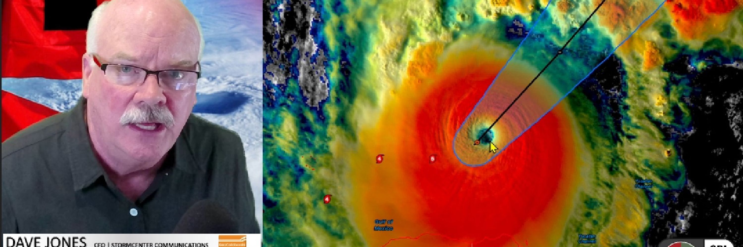
Okay, more for you science/data geeks from today's briefing. Looking at marine traffic, guess where Hurricane Erin is (hint the big hole) and right after Hurricane Hunters dropped a wave drifter, here's the data!!! @geocollaborate.bsky.social 🧪🌀


August 20, 2025 at 11:52 PM
This is what I mean when I say “Research to Operations” can save lives when executed efficiently. It is so exciting to have developed GeoCollaborate to accelerate data into decision making environments! 🧪
Thanks!! Here is the 11am ET update from NHC. Also if you’re interested in our briefings…you can check out this one from yesterday. Another coming later this afternoon. youtu.be/iMpjSYb5uP0


August 20, 2025 at 5:10 PM
Thanks!! Here is the 11am ET update from NHC. Also if you’re interested in our briefings…you can check out this one from yesterday. Another coming later this afternoon. youtu.be/iMpjSYb5uP0