


Derek Law
@gisbandit.bsky.social
Product Manager at Esri | Interests #GIS, #HealthGIS, #Maps, #DataViz
What's New in #ArcGIS #Indoors Q4 2025 tinyurl.com/25ua7ys9
#BuildingMgmt #BIM #GIS #esri #mapping #AEC #GISchat #geospatial #ArcGISIndoors #geosky
#BuildingMgmt #BIM #GIS #esri #mapping #AEC #GISchat #geospatial #ArcGISIndoors #geosky

December 1, 2025 at 2:33 PM
What's New in #ArcGIS #Indoors Q4 2025 tinyurl.com/25ua7ys9
#BuildingMgmt #BIM #GIS #esri #mapping #AEC #GISchat #geospatial #ArcGISIndoors #geosky
#BuildingMgmt #BIM #GIS #esri #mapping #AEC #GISchat #geospatial #ArcGISIndoors #geosky
Reposted by Derek Law

#30DayMapChallenge Day 28: Black. Finalized in After Effects, the planet in dark tones with the world's tectonic plate boundaries slightly animating. Started w/ ArcGIS Pro and Illustrator. My video was too large for Bluesky, so here's the instagram version. 🌎
www.instagram.com/reel/DRncTuB...
www.instagram.com/reel/DRncTuB...
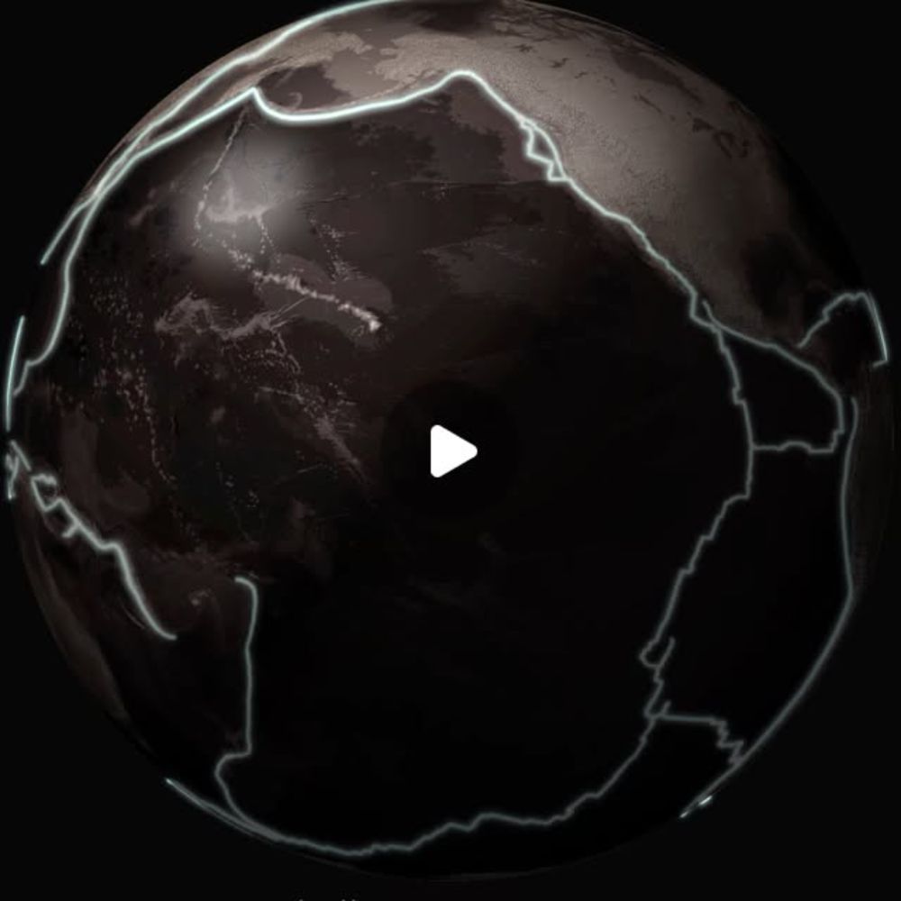
Sarah Bell on Instagram: "#30DayMapChallenge Day 28: Black. Mad with After Effects (Pro and Illustrator as well). The planet centered on the Pacific Ocean with the world's tectonic plate boundaries sl...
This 30-day map challenge showcases a visually striking representation of the Pacific Ocean with animated tectonic plates. By using Adobe After Effects and Illustrator, the creator demonstrates a step...
www.instagram.com
November 28, 2025 at 10:13 PM
#30DayMapChallenge Day 28: Black. Finalized in After Effects, the planet in dark tones with the world's tectonic plate boundaries slightly animating. Started w/ ArcGIS Pro and Illustrator. My video was too large for Bluesky, so here's the instagram version. 🌎
www.instagram.com/reel/DRncTuB...
www.instagram.com/reel/DRncTuB...
Reposted by Derek Law

Day 26: 30 Day Map Challenge - Transport
I mapped the NYC subway at night using the NYC Subway System Authoritative layer for lines and stations, then added a bloom effect so each route family glows over the ArcGIS Streets Night basemap.
codepen.io/cyatteau/pen...
#30DayMapChallenge #ArcGIS #GIS
I mapped the NYC subway at night using the NYC Subway System Authoritative layer for lines and stations, then added a bloom effect so each route family glows over the ArcGIS Streets Night basemap.
codepen.io/cyatteau/pen...
#30DayMapChallenge #ArcGIS #GIS

November 28, 2025 at 5:33 PM
Day 26: 30 Day Map Challenge - Transport
I mapped the NYC subway at night using the NYC Subway System Authoritative layer for lines and stations, then added a bloom effect so each route family glows over the ArcGIS Streets Night basemap.
codepen.io/cyatteau/pen...
#30DayMapChallenge #ArcGIS #GIS
I mapped the NYC subway at night using the NYC Subway System Authoritative layer for lines and stations, then added a bloom effect so each route family glows over the ArcGIS Streets Night basemap.
codepen.io/cyatteau/pen...
#30DayMapChallenge #ArcGIS #GIS
Reposted by Derek Law

💸 The average hourly wage by U.S. state.
🔎 Visual Capitalist
🔎 Visual Capitalist

November 29, 2025 at 1:08 AM
💸 The average hourly wage by U.S. state.
🔎 Visual Capitalist
🔎 Visual Capitalist
What’s New in #Imagery in #ArcGISPro 3.6 (Nov 2025) tinyurl.com/4tv9n7s4
#images #data #RemoteSensing #analysis #GIS #esri #arcgis #mapping #GISchat #geospatial #TheScienceOfWhere #geosky
#images #data #RemoteSensing #analysis #GIS #esri #arcgis #mapping #GISchat #geospatial #TheScienceOfWhere #geosky

November 28, 2025 at 3:00 PM
What’s New in #Imagery in #ArcGISPro 3.6 (Nov 2025) tinyurl.com/4tv9n7s4
#images #data #RemoteSensing #analysis #GIS #esri #arcgis #mapping #GISchat #geospatial #TheScienceOfWhere #geosky
#images #data #RemoteSensing #analysis #GIS #esri #arcgis #mapping #GISchat #geospatial #TheScienceOfWhere #geosky
Reposted by Derek Law

📍 Cette carte recense les phares accessibles au public sur les côtes hexagonales et corses, selon leur statut patrimonial.
#30daymapchallenge – J28 #Black
✍️ Lucie Verdure
📊 IGN - BD Topo / Services des phares et balises DIRM
Découvrez toutes les cartes de nos agents : www.ign.fr/mag/30DayMap...
#30daymapchallenge – J28 #Black
✍️ Lucie Verdure
📊 IGN - BD Topo / Services des phares et balises DIRM
Découvrez toutes les cartes de nos agents : www.ign.fr/mag/30DayMap...

November 28, 2025 at 10:21 AM
📍 Cette carte recense les phares accessibles au public sur les côtes hexagonales et corses, selon leur statut patrimonial.
#30daymapchallenge – J28 #Black
✍️ Lucie Verdure
📊 IGN - BD Topo / Services des phares et balises DIRM
Découvrez toutes les cartes de nos agents : www.ign.fr/mag/30DayMap...
#30daymapchallenge – J28 #Black
✍️ Lucie Verdure
📊 IGN - BD Topo / Services des phares et balises DIRM
Découvrez toutes les cartes de nos agents : www.ign.fr/mag/30DayMap...
Reposted by Derek Law


November 27, 2025 at 4:59 PM
Reposted by Derek Law
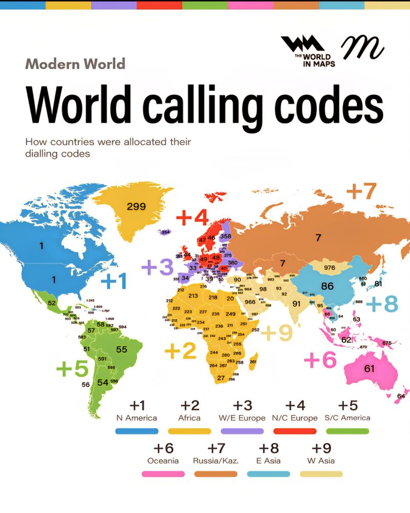
☎️ Calling codes around the world.
November 26, 2025 at 3:09 PM
☎️ Calling codes around the world.
What’s new in #ArcGIS for #Microsoft #Fabric (Nov 2025) tinyurl.com/mshscnd8
#data #processing #analysis #GIS #esri #mapping #location #business #intelligence #GISchat #geospatial #TheScienceOfWhere #geosky @microsoft.com
#data #processing #analysis #GIS #esri #mapping #location #business #intelligence #GISchat #geospatial #TheScienceOfWhere #geosky @microsoft.com

November 27, 2025 at 4:17 PM
What’s new in #ArcGIS for #Microsoft #Fabric (Nov 2025) tinyurl.com/mshscnd8
#data #processing #analysis #GIS #esri #mapping #location #business #intelligence #GISchat #geospatial #TheScienceOfWhere #geosky @microsoft.com
#data #processing #analysis #GIS #esri #mapping #location #business #intelligence #GISchat #geospatial #TheScienceOfWhere #geosky @microsoft.com
Reposted by Derek Law


November 27, 2025 at 3:01 PM
Reposted by Derek Law

A simple, yet beautiful, map by @milosmakesmaps shows Italy’s topography and bathymetry. It’s always nice to see the Po Valley stand out so clearly.

November 27, 2025 at 2:26 PM
A simple, yet beautiful, map by @milosmakesmaps shows Italy’s topography and bathymetry. It’s always nice to see the Po Valley stand out so clearly.
Reposted by Derek Law
Great map by @aquilaflower.bsky.social: "summer climates across North America. I averaged the 1991-2020 climate normals for mean summer temperature and total summer precipitation within 50,000 square kilometer hexagons using data from ClimateNA. "

November 27, 2025 at 12:56 AM
Great map by @aquilaflower.bsky.social: "summer climates across North America. I averaged the 1991-2020 climate normals for mean summer temperature and total summer precipitation within 50,000 square kilometer hexagons using data from ClimateNA. "
Reposted by Derek Law
QUÉ PURÍSIMA PASADA
gis-core.maps.arcgis.com/apps/instant...
gis-core.maps.arcgis.com/apps/instant...
3D Viewer
gis-core.maps.arcgis.com
November 26, 2025 at 8:27 PM
QUÉ PURÍSIMA PASADA
gis-core.maps.arcgis.com/apps/instant...
gis-core.maps.arcgis.com/apps/instant...
Reposted by Derek Law
🌲 Countries that gained the most forest in the last ten years.

November 26, 2025 at 4:19 AM
🌲 Countries that gained the most forest in the last ten years.
Reposted by Derek Law

Do you like #maps? The Independent Map Artists (mapartists.org) has hit a big milestone and now has 50(!) members, all interested in helping with your holiday shopping. Hundreds of maps & mappy goods, straight from small businesses.
Connecting creators & customers is hard; please consider sharing.
Connecting creators & customers is hard; please consider sharing.


November 22, 2025 at 6:15 PM
Do you like #maps? The Independent Map Artists (mapartists.org) has hit a big milestone and now has 50(!) members, all interested in helping with your holiday shopping. Hundreds of maps & mappy goods, straight from small businesses.
Connecting creators & customers is hard; please consider sharing.
Connecting creators & customers is hard; please consider sharing.
What's New in #ArcGIS #Survey123 (Nov 2025) tinyurl.com/4nprb7jh
#forms #surveys #DataCollection #mobile #GIS #AI #esri #fieldwork #ArcGISApps #GISchat #geospatial #TheScienceOfWhere #geosky
#forms #surveys #DataCollection #mobile #GIS #AI #esri #fieldwork #ArcGISApps #GISchat #geospatial #TheScienceOfWhere #geosky

November 26, 2025 at 4:23 PM
What's New in #ArcGIS #Survey123 (Nov 2025) tinyurl.com/4nprb7jh
#forms #surveys #DataCollection #mobile #GIS #AI #esri #fieldwork #ArcGISApps #GISchat #geospatial #TheScienceOfWhere #geosky
#forms #surveys #DataCollection #mobile #GIS #AI #esri #fieldwork #ArcGISApps #GISchat #geospatial #TheScienceOfWhere #geosky
Reposted by Derek Law
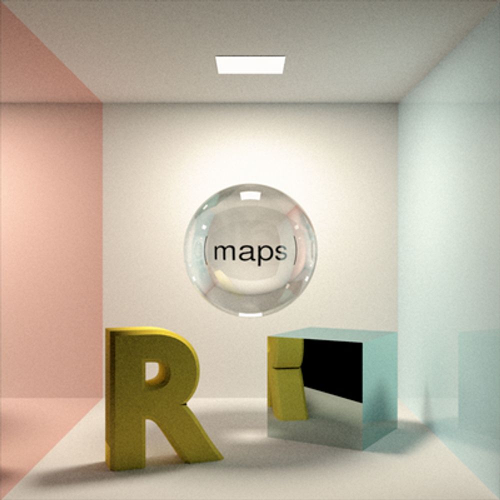
#30DayMapChallenge · Day 26 · Transport. Yet another visualisation of global shipping density. But it's engraved on metal with realistic light and shadow. Because we can do that in R.
#rayshader adventures, an #rstats tale
#rayshader adventures, an #rstats tale
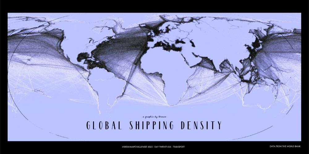
November 26, 2025 at 2:07 PM
#30DayMapChallenge · Day 26 · Transport. Yet another visualisation of global shipping density. But it's engraved on metal with realistic light and shadow. Because we can do that in R.
#rayshader adventures, an #rstats tale
#rayshader adventures, an #rstats tale
Reposted by Derek Law

Mapa de los bosques de Sudamérica (2025): https://mapasmilhaud.com/mapas-geograficos/mapa-de-los-bosques-de-sudamerica-2025/
#Mapas #Maps
#Mapas #Maps

November 26, 2025 at 7:01 AM
Mapa de los bosques de Sudamérica (2025): https://mapasmilhaud.com/mapas-geograficos/mapa-de-los-bosques-de-sudamerica-2025/
#Mapas #Maps
#Mapas #Maps
Reposted by Derek Law
💸 Most (and least) affordable cities in the United Staes.
🔎 Visual Capitalist
🔎 Visual Capitalist

November 26, 2025 at 1:08 AM
💸 Most (and least) affordable cities in the United Staes.
🔎 Visual Capitalist
🔎 Visual Capitalist
Reposted by Derek Law

Italy leads the world in high-speed rail innovation—and now in reimagining stations as community hubs. RFI mapped 18,000 km of rail lines plus 400 data layers around every station, revealing how to turn transit nodes into economic engines. www.esri.com/about/newsro...

November 24, 2025 at 4:45 PM
Italy leads the world in high-speed rail innovation—and now in reimagining stations as community hubs. RFI mapped 18,000 km of rail lines plus 400 data layers around every station, revealing how to turn transit nodes into economic engines. www.esri.com/about/newsro...
Reposted by Derek Law
👥 Population density of Africa.

November 25, 2025 at 4:20 AM
👥 Population density of Africa.
In 3 days, #EsriCanada webinar: #Geospatial Technology - The New Approach for Closing Gaps in #Health #Equity tinyurl.com/4ujcxwde
#healthGIS #publichealth #GIS #esri #arcgis #mapping #GISchat #GISforGood #TheScienceOfWhere #geosky
#healthGIS #publichealth #GIS #esri #arcgis #mapping #GISchat #GISforGood #TheScienceOfWhere #geosky

November 25, 2025 at 3:13 PM
In 3 days, #EsriCanada webinar: #Geospatial Technology - The New Approach for Closing Gaps in #Health #Equity tinyurl.com/4ujcxwde
#healthGIS #publichealth #GIS #esri #arcgis #mapping #GISchat #GISforGood #TheScienceOfWhere #geosky
#healthGIS #publichealth #GIS #esri #arcgis #mapping #GISchat #GISforGood #TheScienceOfWhere #geosky
Reposted by Derek Law

November 25, 2025 at 3:01 PM
Reposted by Derek Law

What Indigenous lands are you on?
In recognition of #NativeAmerican Heritage Month, learn which #Native lands you live on and more. Indigenous-led nonprofit, Native Land Digital, allows users to click on labels across the globe —or a specific location— to see #Indigenous nations. buff.ly/QQpI4rb
In recognition of #NativeAmerican Heritage Month, learn which #Native lands you live on and more. Indigenous-led nonprofit, Native Land Digital, allows users to click on labels across the globe —or a specific location— to see #Indigenous nations. buff.ly/QQpI4rb

November 25, 2025 at 2:03 PM
What Indigenous lands are you on?
In recognition of #NativeAmerican Heritage Month, learn which #Native lands you live on and more. Indigenous-led nonprofit, Native Land Digital, allows users to click on labels across the globe —or a specific location— to see #Indigenous nations. buff.ly/QQpI4rb
In recognition of #NativeAmerican Heritage Month, learn which #Native lands you live on and more. Indigenous-led nonprofit, Native Land Digital, allows users to click on labels across the globe —or a specific location— to see #Indigenous nations. buff.ly/QQpI4rb
Reposted by Derek Law

November 25, 2025 at 1:33 AM