


iWeatherNet🌪⚡️
@iweather.bsky.social
55 followers
21 following
210 posts
Local forecasts, #weather articles, storm chasers, along with interactive storm radar and award-winning journalists and meteorologists ⛈🌪⚡️https://www.iweathernet.com/ #StormNet #IweatherNet #WX
Posts
Media
Videos
Starter Packs


iWeatherNet🌪⚡️
@iweather.bsky.social
· Sep 26
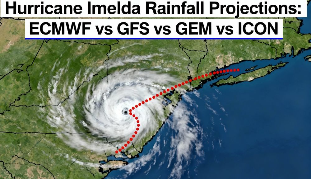
Future Imelda Could Bring Historic Rainfall and Flooding to Coastal Georgia and the Carolinas
As we approach the final days of September, meteorologists are keeping a close watch on an evolving tropical system — currently known as Potential Tropical Cyclone 9 (PTC 9; formerly Invest 94L) — which is likely to become Tropical Storm or Hurricane Imelda by this weekend. This is a complicated forecast due to the more dominant hurricane Humberto. The system’s track and eventual impacts remain highly uncertain, but early signals point to the potential for an
www.iweathernet.com

iWeatherNet🌪⚡️
@iweather.bsky.social
· Sep 26
Washington’s Emergency: Wildfires, Drought, and Record Dryness
As the water year ends, Washington State is in crisis—faced with historic drought and relentless wildfires. This double blow is taking a heavy toll on communities, landscapes, and resources. Labor Mountain Fire at over 17,000 acres in September 2025. Unprecedented Drought and Water Shortages 100% of Washington is gripped by drought. 25.3% of the state is experiencing Extreme Drought (D3).
www.iweathernet.com
iWeatherNet🌪⚡️
@iweather.bsky.social
· Sep 25

Humberto and Imelda: Two Major Atlantic Hurricanes Could Interact in Rare Fujiwhara Effect
Atlantic Fujiwhara Hurricane Records Comparison 2025: Could Humberto and Imelda Dance?The 2025 Atlantic hurricane season has already been one for the record books, and now a potential Fujiwhara interaction between Tropical Storm Humberto and Tropical Disturbance 94L (likely to become Tropical Storm or Hurricane Imelda) has caught the attention of meteorologists and storm-watchers alike. While rare, this phenomenon—where two tropical cyclones orbit each other like celestial bodies—has precedent in Atlantic hurricane history.
www.iweathernet.com
iWeatherNet🌪⚡️
@iweather.bsky.social
· Sep 24
iWeatherNet🌪⚡️
@iweather.bsky.social
· Sep 12

Oklahoma’s October Ice Storms: History, Preparation, and What’s Next for Winter Weather
When Oklahoma thinks October, most picture pumpkin patches and football—not a landscape frozen under more than an inch of ice. But October 2020 rewrote the state’s weather rule book. That historic ice storm hammered Oklahoma City, plunged over 300,000 residents into darkness, toppled trees, and cost millions in repairs—weeks before Halloween. Why did it happen, how does it compare to other cold snaps, and what’s the smart way to prep for early winter chaos as climate patterns shift?
www.iweathernet.com
iWeatherNet🌪⚡️
@iweather.bsky.social
· Aug 10

Could a New Google AI Model Be Foretelling the Path of the First Hurricane of 2025?
A large area of disorganized showers and thunderstorms, known as Invest 97L, is located just off the west coast of Africa. It has the best chance so far this season of becoming the first hurricane as it moves west-northwest across the Atlantic. Most models show this system turning north into the open Atlantic, well before reaching the U.S. or the Gulf.
www.iweathernet.com
iWeatherNet🌪⚡️
@iweather.bsky.social
· Aug 9

DFW Weather Records Broken in 2025: Wind, Heat, and Historic Trends Across North Texas
August 2025 will go down as one of the more memorable months in recent North Texas weather history. In the early morning hours of August 4, an intense microburst at Dallas-Fort Worth International Airport produced a staggering wind gust of 89 mph — the highest ever recorded at the site. The force was strong enough to cause minor structural damage in nearby areas, briefly disrupt air traffic, and leave many residents with an unforgettable wake-up call.
www.iweathernet.com
iWeatherNet🌪⚡️
@iweather.bsky.social
· Aug 5

The Best Meteor Shower of the Year Peaks August 12–13
The Perseid meteor shower — widely considered the best of the year — will put on its peak performance the nights of August 12 and 13, with up to 50 meteors per hour visible under clear, dark skies. No telescope? No problem. You don’t need special gear to enjoy this lunar show. Just find a dark spot, let your eyes adjust for about 30 minutes, and look up.
www.iweathernet.com
iWeatherNet🌪⚡️
@iweather.bsky.social
· Aug 5

iWeatherNet🌪⚡️
@iweather.bsky.social
· Aug 1

World Record: 515-Mile Lightning Strike Confirmed Over Central U.S.
The World Meteorological Organization has certified a new world record for the longest lightning strike on record, a single bolt that measured 515 miles in length. The flash occurred on October 22, 2017, within a massive mesoscale convective system (MCS) that extended across the Central Plains of the United States. While the majority of the discharge occurred within the clouds, this single megaflash was responsible for 64 cloud-to-ground strikes, impacting areas from eastern Texas to Kansas City, Missouri.
www.iweathernet.com
iWeatherNet🌪⚡️
@iweather.bsky.social
· Jul 30

Pacific Awakens: M8.8 Megathrust Quake Unleashes Tsunami Threat, Echoing Hawaii’s Past Devastation
Heavy tsunami flooding seen along the Russian Pacific coast. The port facilities in the town of Severo-Kurilsk sit underwater after the first tsunami wave hit. The U.S. Geological Survey (USGS) has officially upgraded the recent earthquake off the eastern coast of Russia to a staggering Magnitude 8.8, tying it as the fifth-strongest earthquake ever recorded globally. This colossal megathrust quake has generated a significant tsunami threat across the Pacific, prompting evacuations in Hawaii and warnings along the entire U.S.
www.iweathernet.com
iWeatherNet🌪⚡️
@iweather.bsky.social
· Jul 18

Fact Check: What Is a Firenado, and Can Wildfires Really Cause Tornadoes?
No, It's Not AI or the Apocalypse — That "Firenado" in Utah Was Very Real This week, a jaw-dropping video out of southeastern Utah had social media buzzing. It showed what looked like a swirling vortex of flame rising from the landscape—a twisting column of fire churning against the sky like something out of a Hollywood disaster flick. Some called it a “firenado.” Others said it must be AI-generated.
www.iweathernet.com

iWeatherNet🌪⚡️
@iweather.bsky.social
· Jul 18
iWeatherNet🌪⚡️
@iweather.bsky.social
· Jul 6
Deadly Texas Flooding Had Ample Warnings, Dismissing Cloud Seeding and Other False Claims
As a meteorologist, my heart sinks when I see the devastation caused by events like the recent catastrophic flooding in Texas, which has tragically claimed over 50 lives, with many still missing, including 30 or more girls from a summer camp along the Guadalupe River. In the wake of such a disaster, it’s natural for people to ask, "Did this come out of nowhere?
www.iweathernet.com
iWeatherNet🌪⚡️
@iweather.bsky.social
· Jun 20
Weather Strikes Again: I-40 West Shuts Down at NC/TN Border, Disrupting Cross-Country Journeys and Mountain Getaways
Pigeon River Gorge, NC/TN – For the second time in less than a year, the vital I-40 West corridor near the North Carolina-Tennessee border has succumbed to the relentless power of nature. A substantial rockslide and severe flooding in the picturesque yet precarious Pigeon River Gorge have triggered the indefinite closure of I-40 West at Exit 20 in North Carolina. This shutdown, effective June 20, 2025, is sending ripples of disruption across cross-country travel, impacting everyone from long-haul truckers to families planning their summer vacations in the Smoky Mountains.
www.iweathernet.com