


J.-A. Olive
@jaodynamics.bsky.social
Geodynamicist @CNRS/ENS. I stretch, squeeze and break *theoretical* tectonic plates for a living. https://jaolive.weebly.com
Reposted by J.-A. Olive

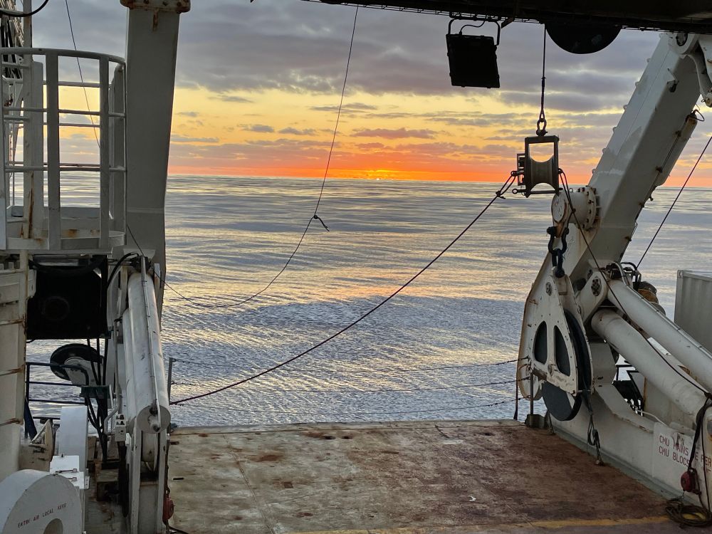
The 2026 GEODAMS team safely arrived close to Possession Island in the Crozet archipelago a few days ago. A penguin crowd welcomed us under a very bright sky and with the traditional croziflette that follows... 🐧 🍽️
We’ve had our fill, both for the eyes and the stomach.
We’ve had our fill, both for the eyes and the stomach.


January 24, 2026 at 2:40 PM
The 2026 GEODAMS team safely arrived close to Possession Island in the Crozet archipelago a few days ago. A penguin crowd welcomed us under a very bright sky and with the traditional croziflette that follows... 🐧 🍽️
We’ve had our fill, both for the eyes and the stomach.
We’ve had our fill, both for the eyes and the stomach.
Reposted by J.-A. Olive
The OHA-GEODAMS team is back to document how the Indian Ocean grows.
Cruise #3 on board Marion Dufresne left La Réunion Island a few days ago to maintain the multi-sensor observatory on the South East Indian Ridge. Follow us on this new adventure!
(credit photo: Ewen & Didier)
Cruise #3 on board Marion Dufresne left La Réunion Island a few days ago to maintain the multi-sensor observatory on the South East Indian Ridge. Follow us on this new adventure!
(credit photo: Ewen & Didier)

January 20, 2026 at 5:43 PM
The OHA-GEODAMS team is back to document how the Indian Ocean grows.
Cruise #3 on board Marion Dufresne left La Réunion Island a few days ago to maintain the multi-sensor observatory on the South East Indian Ridge. Follow us on this new adventure!
(credit photo: Ewen & Didier)
Cruise #3 on board Marion Dufresne left La Réunion Island a few days ago to maintain the multi-sensor observatory on the South East Indian Ridge. Follow us on this new adventure!
(credit photo: Ewen & Didier)
Reposted by J.-A. Olive

Researchers successfully predicted a seafloor eruption at a midocean ridge in April 2025 by tracking hydrothermal fluid temperatures. A 35-year record reveals that temperature increases from 350°C to 390°C may reliably forecast eruptions. In PNAS: https://ow.ly/lrwZ50Xf1v0

October 20, 2025 at 4:02 PM
Researchers successfully predicted a seafloor eruption at a midocean ridge in April 2025 by tracking hydrothermal fluid temperatures. A 35-year record reveals that temperature increases from 350°C to 390°C may reliably forecast eruptions. In PNAS: https://ow.ly/lrwZ50Xf1v0
🎓 #PhD opportunity in Paris! Join us at @geosciences.bsky.social to study how magma reservoirs beneath mid-ocean ridges pressurize and trigger eruptions. Part of the @erc.europa.eu #SeaSALT project with strong international links. Background in (geo)physics? Apply now! tinyurl.com/yupkweya
Portail Emploi CNRS - Offre d'emploi - PhD position on the dynamics of mid-ocean ridge magma reservoirs (M/F)
emploi.cnrs.fr
May 19, 2025 at 7:13 AM
🎓 #PhD opportunity in Paris! Join us at @geosciences.bsky.social to study how magma reservoirs beneath mid-ocean ridges pressurize and trigger eruptions. Part of the @erc.europa.eu #SeaSALT project with strong international links. Background in (geo)physics? Apply now! tinyurl.com/yupkweya
Reposted by J.-A. Olive
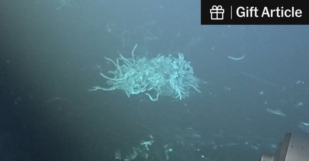
🧪⚒️ The New eruption @ the East Pacific Rise after a cycle of melt accumulation & seafloor uplift. Several years of follow up by Thibaut Barreyre (CNRS@GeoOcean) & coPIs will tell how these events build the oceanic crust, 1 eruption @ a time - & comeback of ecosystems
www.nytimes.com/2025/05/02/s...
www.nytimes.com/2025/05/02/s...

Volcanic Eruption in Deep Ocean Ridge Is Witnessed by Scientists for First Time
Researchers diving in a submersible in the eastern Pacific realized that the landscape they had studied the day before had been glassed over by fresh lava.
www.nytimes.com
May 2, 2025 at 5:25 PM
🧪⚒️ The New eruption @ the East Pacific Rise after a cycle of melt accumulation & seafloor uplift. Several years of follow up by Thibaut Barreyre (CNRS@GeoOcean) & coPIs will tell how these events build the oceanic crust, 1 eruption @ a time - & comeback of ecosystems
www.nytimes.com/2025/05/02/s...
www.nytimes.com/2025/05/02/s...
Reposted by J.-A. Olive
**BIG NEWS in the geology world!** For the first time, scientists spotted an active eruption along the mid-ocean ridge!!
They visited the hydrothermal vent the day before, where a vibrant ecosystem thrived in the sweltering water. The next day, everything was gone. ⚒️🧪
My latest for @nytimes.com
They visited the hydrothermal vent the day before, where a vibrant ecosystem thrived in the sweltering water. The next day, everything was gone. ⚒️🧪
My latest for @nytimes.com
Volcanic Eruption in Deep Ocean Ridge Is Witnessed by Scientists for First Time (Gift Article)
Researchers diving in a submersible in the eastern Pacific realized that the landscape they had studied the day before had been glassed over by fresh lava.
www.nytimes.com
May 2, 2025 at 5:03 PM
**BIG NEWS in the geology world!** For the first time, scientists spotted an active eruption along the mid-ocean ridge!!
They visited the hydrothermal vent the day before, where a vibrant ecosystem thrived in the sweltering water. The next day, everything was gone. ⚒️🧪
My latest for @nytimes.com
They visited the hydrothermal vent the day before, where a vibrant ecosystem thrived in the sweltering water. The next day, everything was gone. ⚒️🧪
My latest for @nytimes.com
Reposted by J.-A. Olive
[RDV 16h !] A la fin du XXe siècle, les travaux de l’océanographe Marie Tharp ont bouleversé la géologie et notre connaissance de la tectonique des plaques. Quelles furent ces découvertes et leurs impacts ? tinyurl.com/26xwkx4y avec @jescartin.bsky.social, Cécile Prigent et Laurent Jolivet

April 2, 2025 at 10:07 AM
[RDV 16h !] A la fin du XXe siècle, les travaux de l’océanographe Marie Tharp ont bouleversé la géologie et notre connaissance de la tectonique des plaques. Quelles furent ces découvertes et leurs impacts ? tinyurl.com/26xwkx4y avec @jescartin.bsky.social, Cécile Prigent et Laurent Jolivet
Reposted by J.-A. Olive
If it all goes well, our now-complete observatory will be the first to document seafloor spreading and transform faulting events with geodesy, hydro-acoustics, and seismology! 🤞

February 1, 2025 at 7:18 AM
If it all goes well, our now-complete observatory will be the first to document seafloor spreading and transform faulting events with geodesy, hydro-acoustics, and seismology! 🤞
Reposted by J.-A. Olive
Last, but not least, we also recovered and re-deployed an A-0-A pressure sensor, right in the middle of the ridge's axial valley. This state-of-the-art instrument corrects its own drift by regularly re-calibrating itself against an inner chamber where the pressure is known.

February 1, 2025 at 7:18 AM
Last, but not least, we also recovered and re-deployed an A-0-A pressure sensor, right in the middle of the ridge's axial valley. This state-of-the-art instrument corrects its own drift by regularly re-calibrating itself against an inner chamber where the pressure is known.
watching the seafloor spread
The core of the OHA-GEODAMS project is to measure active deformation for 3 years on the Southeast Indian Ridge and the Amsterdam transform fault. To this end, in February 2024, we deployed 15 acoustic beacons that have been pinging each other every few hours ever since.

January 31, 2025 at 4:22 AM
watching the seafloor spread

Reposted by J.-A. Olive
For the last ~10 days, we've been hard at work on and around the Southeast Indian Ridge at 37ºS to recover and redeploy a bunch of geophysical instruments. Let's break it down 👇

January 30, 2025 at 9:17 AM
For the last ~10 days, we've been hard at work on and around the Southeast Indian Ridge at 37ºS to recover and redeploy a bunch of geophysical instruments. Let's break it down 👇
and… welcome back!
January 29, 2025 at 6:24 AM
and… welcome back!
4-8 watch best watch

January 28, 2025 at 6:51 AM
4-8 watch best watch
Reposted by J.-A. Olive
⚒️🧪🌊 25/25 -The #VG2024 leader completed the race after 64j19h22 at 17.8 knots. More than 26700 nm (~51000 km) crossing 4 major mid-ocean ridges (Mid-Atlantic, Southwest, South East & East Pacific Rise) & around Antarctica. Thnks to @jie-chen.bsky.social for the Spilhaus map: doi.org/10.1038/s415...

January 16, 2025 at 1:12 PM
⚒️🧪🌊 25/25 -The #VG2024 leader completed the race after 64j19h22 at 17.8 knots. More than 26700 nm (~51000 km) crossing 4 major mid-ocean ridges (Mid-Atlantic, Southwest, South East & East Pacific Rise) & around Antarctica. Thnks to @jie-chen.bsky.social for the Spilhaus map: doi.org/10.1038/s415...
off you go, Glidy! come back with lots of 🐋 sounds

January 20, 2025 at 6:54 AM
off you go, Glidy! come back with lots of 🐋 sounds
Reposted by J.-A. Olive
A few days ago, we deployed a Sea Explorer glider developed by ALSEAMAR and owned by ENSTA Bretagne at the location of our first hydrophone, southeast of Amsterdam island.

January 20, 2025 at 6:16 AM
A few days ago, we deployed a Sea Explorer glider developed by ALSEAMAR and owned by ENSTA Bretagne at the location of our first hydrophone, southeast of Amsterdam island.
Reposted by J.-A. Olive
As we make our way to our study area, we map the seafloor under the ship! 🌊 Our multibeam echosounder sends acoustic waves to the ocean floor and records how much time they take to bounce back.

January 19, 2025 at 12:02 PM
As we make our way to our study area, we map the seafloor under the ship! 🌊 Our multibeam echosounder sends acoustic waves to the ocean floor and records how much time they take to bounce back.
Reposted by J.-A. Olive
A tradition aboard the Marion Dufresne is to stamp letters to be mailed from the French Southern and Antarctic Lands. The ship captain, chief mechanic, doctor... each have their own stamp, and the science teams make new, custom ones every year!


January 14, 2025 at 1:43 PM
A tradition aboard the Marion Dufresne is to stamp letters to be mailed from the French Southern and Antarctic Lands. The ship captain, chief mechanic, doctor... each have their own stamp, and the science teams make new, custom ones every year!
Reposted by J.-A. Olive
⚒️🧪🌊 24/n - & the #VG2024 lead is near King's Trough, a failed rift formed perpendicular to the ridge axis 40 to 25 Myrs ago, now fossilised. First named by Laughton in '65 and described in detail by Matthews et al. in '69, the rift is a few km deep, and reaches 6000 m bsl @ Keep Deep to the East.

January 12, 2025 at 3:44 PM
⚒️🧪🌊 24/n - & the #VG2024 lead is near King's Trough, a failed rift formed perpendicular to the ridge axis 40 to 25 Myrs ago, now fossilised. First named by Laughton in '65 and described in detail by Matthews et al. in '69, the rift is a few km deep, and reaches 6000 m bsl @ Keep Deep to the East.
Reposted by J.-A. Olive
We're back in business after a rough storm west of Kerguelen! We're now sheltered from the waves (but not the wind!) in the Gulf of Morbihan, enjoying our first views of the island and prepping the logistics of next week's deployments.


January 13, 2025 at 11:52 AM
We're back in business after a rough storm west of Kerguelen! We're now sheltered from the waves (but not the wind!) in the Gulf of Morbihan, enjoying our first views of the island and prepping the logistics of next week's deployments.
Reposted by J.-A. Olive
⚒️🧪🌊 23/n - The #VG2024 sailed over Great Meteor Guyot - part of a set of hotspot seamounts formed 20 to Myrs ago, possibly linked to the Azores hotspot to the N. The Guyot is flat topped due to wave erosion & later subsidence. It was 1st mapped & named during the N Atlantic Meteor cruise in 1937.

January 12, 2025 at 2:17 PM
⚒️🧪🌊 23/n - The #VG2024 sailed over Great Meteor Guyot - part of a set of hotspot seamounts formed 20 to Myrs ago, possibly linked to the Azores hotspot to the N. The Guyot is flat topped due to wave erosion & later subsidence. It was 1st mapped & named during the N Atlantic Meteor cruise in 1937.
our regularly scheduled @geodams.bsky.social programming will resume when the ship returns to a more horizontal position
January 10, 2025 at 5:19 AM
our regularly scheduled @geodams.bsky.social programming will resume when the ship returns to a more horizontal position
Reposted by J.-A. Olive
Meet the #GEODAMS 2025 team! ⚒️ @earth-science.bsky.social Right to left, back to front 👇

January 5, 2025 at 5:02 PM
Meet the #GEODAMS 2025 team! ⚒️ @earth-science.bsky.social Right to left, back to front 👇
but none can beat Björk youtu.be/-WnzRqCK6Fs?...
January 5, 2025 at 3:07 PM
but none can beat Björk youtu.be/-WnzRqCK6Fs?...