


liam o’connell
@liamoc.bsky.social
city kid thinking about trains • he/him
Reposted by liam o’connell

Sunday evening reminder: I'm hiring! Job posting closes Christmas Eve, so if you're interested, get your application in now. I promise the work is meaningful and mostly fun :-)
Big news: I am hiring! We're looking for a Senior Project Coordinator to join the Strategic Transit Planning team at the MBTA and work on regional coordination, long-range strategy, change management, and multimodal planning. www.governmentjobs.com/careers/mbta...

Senior Project Coordinator
The Senior Project Coordinator will be primarily responsible for supporting MBTA’s long-term and strategic planning initiatives, such as Full T Ahead and the MBTA Climate Assessment, including assisti...
www.governmentjobs.com
December 22, 2025 at 1:53 AM
Sunday evening reminder: I'm hiring! Job posting closes Christmas Eve, so if you're interested, get your application in now. I promise the work is meaningful and mostly fun :-)
Reposted by liam o’connell

No disrespect to Balko and his work against the militarized policing, but this is backwards. It’s otherwise progressive people who drop their principles to defend our system of auto dependence and backfill equity or anti-carceral justifications for it.

I think it was a huge mistake to make our society so car-dependent. But man. The Discourse today is a good reminder that when it comes to roadways policy, otherwise progressive anti-car people quickly become some of the most pro-carceral, anti-civil liberties people on the planet.
December 12, 2025 at 11:46 PM
No disrespect to Balko and his work against the militarized policing, but this is backwards. It’s otherwise progressive people who drop their principles to defend our system of auto dependence and backfill equity or anti-carceral justifications for it.
Reposted by liam o’connell
Such an elemental yet overlooked reality of planning. If you don't:
- Design a new route to add value to the network overall
- Make changes to the existing network to incorporate the new asset
...you're kneecapping yourself. A key part of transit hist:
homesignalblog.wordpress.com/2024/07/12/t...
- Design a new route to add value to the network overall
- Make changes to the existing network to incorporate the new asset
...you're kneecapping yourself. A key part of transit hist:
homesignalblog.wordpress.com/2024/07/12/t...
December 1, 2025 at 4:49 AM
Such an elemental yet overlooked reality of planning. If you don't:
- Design a new route to add value to the network overall
- Make changes to the existing network to incorporate the new asset
...you're kneecapping yourself. A key part of transit hist:
homesignalblog.wordpress.com/2024/07/12/t...
- Design a new route to add value to the network overall
- Make changes to the existing network to incorporate the new asset
...you're kneecapping yourself. A key part of transit hist:
homesignalblog.wordpress.com/2024/07/12/t...
Reposted by liam o’connell

I think it's shameful that during a second Trump administration, and after NYC voters rejected a return to moderate, conciliatory governance, that a Democrat would tout the entirety of the Council's Republican caucus as her supporters.

Menin says she'll work with Mamdani "on a shared agenda that makes New York more affordable."
GOP members backing Menin, tho, are likely to look to her to be a check on Mamdani. Vickie Paladino said she's with Menin because she "understands all perspectives." www.nydailynews.com/2025/11/26/j...
GOP members backing Menin, tho, are likely to look to her to be a check on Mamdani. Vickie Paladino said she's with Menin because she "understands all perspectives." www.nydailynews.com/2025/11/26/j...

Julie Menin claims victory in NYC Council speaker race with more than 65 percent support
Manhattan Councilwoman Julie Menin claimed victory Wednesday in the City Council speaker’s race after saying she’s secured commitments of support from a super majority of her colleague…
www.nydailynews.com
November 26, 2025 at 5:15 PM
I think it's shameful that during a second Trump administration, and after NYC voters rejected a return to moderate, conciliatory governance, that a Democrat would tout the entirety of the Council's Republican caucus as her supporters.
Reposted by liam o’connell

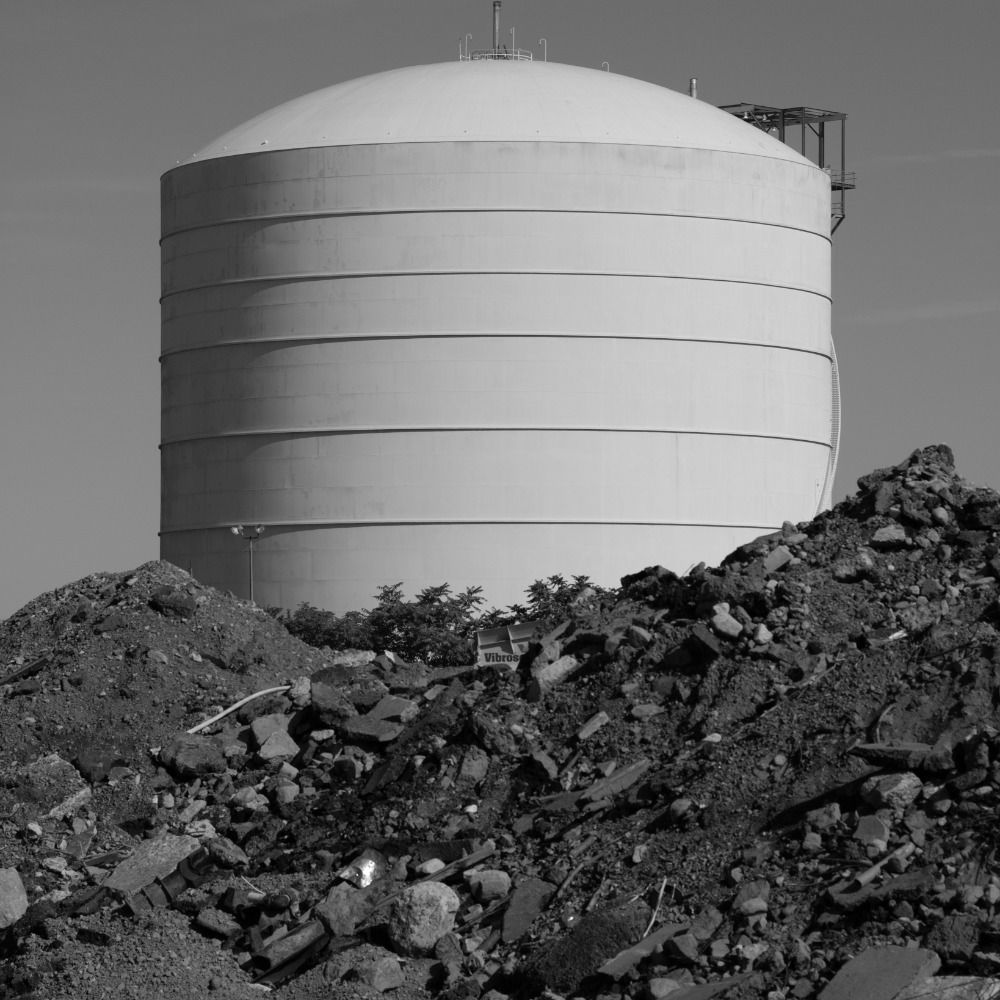
Back in spring, I made final images of some of the buildings slated for demolition along the path of the Red Line Extension.
These were captured over a monthlong span when demolition permits were getting greenlit, wrecking crews finally dispatching after asbestos remediation and utility shutoffs.
These were captured over a monthlong span when demolition permits were getting greenlit, wrecking crews finally dispatching after asbestos remediation and utility shutoffs.


November 26, 2025 at 4:30 AM
Back in spring, I made final images of some of the buildings slated for demolition along the path of the Red Line Extension.
These were captured over a monthlong span when demolition permits were getting greenlit, wrecking crews finally dispatching after asbestos remediation and utility shutoffs.
These were captured over a monthlong span when demolition permits were getting greenlit, wrecking crews finally dispatching after asbestos remediation and utility shutoffs.
Reposted by liam o’connell
The US Steel Edgar Thomson Works plant is a fantastic photo subject, and I was lucky enough to catch a Union Railroad movement with nice backlighting when I visited there recently. www.flickr.com/gp/traing33k...


October 20, 2025 at 6:45 PM
The US Steel Edgar Thomson Works plant is a fantastic photo subject, and I was lucky enough to catch a Union Railroad movement with nice backlighting when I visited there recently. www.flickr.com/gp/traing33k...
Reposted by liam o’connell
I've had zero to do with it other than watching as an Orange Line rider, but rapid implementation of dropbacks on the OL is one of the coolest things I've seen in my time at the MBTA. From a process improvement exploration project to full-bore implementation in just a few months.

The MBTA confronts an "unintended consequence" of all its recent Orange Line improvements: traffic www.wbur.org/news/2025/11... @wbur.org

The Orange Line has gotten so much better it has a new problem: Traffic
An "unintended consequence" of all the recent improvements, Orange Line trains are now running into delays due to congestion at the end of the line. However, the MBTA has a plan to ease the issue. Mee...
www.wbur.org
November 21, 2025 at 1:21 PM
I've had zero to do with it other than watching as an Orange Line rider, but rapid implementation of dropbacks on the OL is one of the coolest things I've seen in my time at the MBTA. From a process improvement exploration project to full-bore implementation in just a few months.
very cool system, but it’s always seemed a bizarre choice that the rem is not identified as part of the metro system, even moreso now that it’s expanded. i know that rem is legally, technically its own thing but come on: it’s really just more metro!

the biggest section of the REM (and imo the most important phase) opened today, basically extending a highway-median suburban branch into a full-fledged 50 km north-south metro across the montreal region
montreal now has a 119-kilometre metro system with 87 stations, by far the largest in canada!
montreal now has a 119-kilometre metro system with 87 stations, by far the largest in canada!

November 15, 2025 at 10:10 PM
very cool system, but it’s always seemed a bizarre choice that the rem is not identified as part of the metro system, even moreso now that it’s expanded. i know that rem is legally, technically its own thing but come on: it’s really just more metro!
Reposted by liam o’connell

I am continually impressed by Alissa's coverage of LA transportation and also how insane LA's transportation spending is.

LA is building a new $1.5 billion freeway into LAX.
The very same airport where we just spent $2 billion on the people mover — actually, more like $3 billion, plus another $900 million if you count Metro's investment in the LAX station; so let's just say $4 billion — to make cars go away
The very same airport where we just spent $2 billion on the people mover — actually, more like $3 billion, plus another $900 million if you count Metro's investment in the LAX station; so let's just say $4 billion — to make cars go away

Air traffic control
The LAX-pressway must be stopped
www.torched.la
October 24, 2025 at 5:27 PM
I am continually impressed by Alissa's coverage of LA transportation and also how insane LA's transportation spending is.
For decades, everyone has been wondering: would the Pittsburgh Skybus actually have worked? 50 years after the project was canceled, we have the tools* (Subway Builder) to find out.
(*This is, at best, half-serious.)
(*This is, at best, half-serious.)


October 20, 2025 at 4:30 AM
For decades, everyone has been wondering: would the Pittsburgh Skybus actually have worked? 50 years after the project was canceled, we have the tools* (Subway Builder) to find out.
(*This is, at best, half-serious.)
(*This is, at best, half-serious.)
Reposted by liam o’connell

New Haven’s fascinating parkitecture, part 2


September 15, 2025 at 9:36 PM
New Haven’s fascinating parkitecture, part 2
hakeem jeffries sees his highest political calling as sniping on brooklyn democratic factional battles and new yorkers should have the opportunity to vote to free up his calendar so he can devote more time to that
September 15, 2025 at 12:50 AM
hakeem jeffries sees his highest political calling as sniping on brooklyn democratic factional battles and new yorkers should have the opportunity to vote to free up his calendar so he can devote more time to that
Reposted by liam o’connell

RAN after this driver to take a picture of his incredible vest!!! I want one so bad but he said they’re only available for MTA workers 🏆🚍🏆

September 8, 2025 at 11:12 PM
RAN after this driver to take a picture of his incredible vest!!! I want one so bad but he said they’re only available for MTA workers 🏆🚍🏆
Reposted by liam o’connell

there was a time when Seoul Metro management and local politicians balked at the idea of installing platform screen doors because of its cost. they pointed to the New York City MTA as an example as to why NOT install platform screen doors
![Politicians were divided on feasibility. While some were supportive, many on the city council dismissed a system-wide PSD installation plan based on cost and lack of domestic expertise in installation. PSDs were initially estimated to cost between 2 billion and 3 billion won (approximately US$1.8 million to $2.6 million) per station – and more than 500 billion won for all 250+ Seoul Metro stations.8 If completed, this would increase Seoul Metro’s existing construction debt of 1.6 trillion won by nearly a third. For management, this was repellent. Besides, it was unclear if anyone could build it for that price. Once, the city council asked Seoul Metro staff how many firms in South Korea could even do the installation work; they said one – and a dubious company at that.9
Those against PSDs repeatedly said they were economically “impossible.” Internally, policymakers and bureaucrats in the Seoul Metropolitan Government echoed the sentiment:
Economists and experts ask if there is a need to install platform screen doors considering its huge expenses and lengthy construction periods. If there is an accident, [the Metro] can compensate. … Even in the United States, systems like the New York City subway have not installed one over its 100-year history.10](https://cdn.bsky.app/img/feed_thumbnail/plain/did:plc:njnk7mrdtdc66v7a7ur6af5k/bafkreie3k435v22hj742p2nwanlo7c2cyxuucaibdvl7l626smp5cgrutq@jpeg)
September 6, 2025 at 4:41 PM
there was a time when Seoul Metro management and local politicians balked at the idea of installing platform screen doors because of its cost. they pointed to the New York City MTA as an example as to why NOT install platform screen doors
Reposted by liam o’connell
Read this eloquent and pained thread from my good friend and colleague @zagush.bsky.social. The pain caused by short-sighted decisions about transit in our society is immense. And as he says, in many cases choices to weaken transit make achieving policy goals literally impossible.
I've watched every minute of the recorded oral comments & read the hundreds of written submissions to
@ripta.com in response to the painful service reductions and segment and outright eliminations on the table. This 🧵 is strictly my own and is not an official RIPTA statement.
@ripta.com in response to the painful service reductions and segment and outright eliminations on the table. This 🧵 is strictly my own and is not an official RIPTA statement.
August 7, 2025 at 12:40 AM
Read this eloquent and pained thread from my good friend and colleague @zagush.bsky.social. The pain caused by short-sighted decisions about transit in our society is immense. And as he says, in many cases choices to weaken transit make achieving policy goals literally impossible.
Reposted by liam o’connell
7) Pittsburgh: the second rail tunnel should connect the East and West Busways via Liberty Ave/former Wabash bridge alignment. Also capturing South Hills branch and a new one to Oakland/Hazelwood @struthious.bsky.social
www.google.com/maps/d/edit?...
www.google.com/maps/d/edit?...


August 4, 2025 at 2:43 PM
7) Pittsburgh: the second rail tunnel should connect the East and West Busways via Liberty Ave/former Wabash bridge alignment. Also capturing South Hills branch and a new one to Oakland/Hazelwood @struthious.bsky.social
www.google.com/maps/d/edit?...
www.google.com/maps/d/edit?...
Reposted by liam o’connell
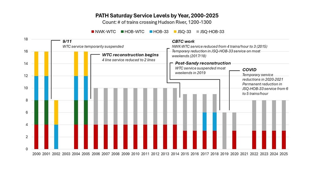
A lot has happened to PATH in the past 25 years -- 9/11, major construction work, COVID, etc. But consistent across all of these events have been ensuing reductions in off-pk service levels: since 2005, the number of PATH trips crossing the Hudson on Saturdays has fallen by *50%*
July 27, 2025 at 4:19 PM
A lot has happened to PATH in the past 25 years -- 9/11, major construction work, COVID, etc. But consistent across all of these events have been ensuing reductions in off-pk service levels: since 2005, the number of PATH trips crossing the Hudson on Saturdays has fallen by *50%*
Reposted by liam o’connell
Free bus proponents have this default resignation over any possible efficiencies from buses in subway deserts, stemming from a general distrust of the transit agency. A mentality driven from austerity and not abundance. As someone who works in transit to make it better, this is hugely depressing!
the MTA has a huge equity issue - the subway doesn't go everywhere - and free buses are one way to address that. transit nerd urbanists tend to skip the equity issue entirely and will tell you to increase bus service on high density routes - for efficiency
July 9, 2025 at 12:28 PM
Free bus proponents have this default resignation over any possible efficiencies from buses in subway deserts, stemming from a general distrust of the transit agency. A mentality driven from austerity and not abundance. As someone who works in transit to make it better, this is hugely depressing!
Reposted by liam o’connell

the republican party is a modern day Slave Power and the only way forward for this country is to sweep it into the ash heap of history
July 3, 2025 at 7:16 PM
the republican party is a modern day Slave Power and the only way forward for this country is to sweep it into the ash heap of history
Reposted by liam o’connell

Sigh. Transit advocates have been asking for *years* for more resources to make buses better: Countdown clocks, car cameras, more service, accessibility training, sheltered bus stops, TPS, and so on. Free fares was never it and we're no closer to getting what we've BEEN asking for w/ this attitude.
June 26, 2025 at 4:11 PM
Sigh. Transit advocates have been asking for *years* for more resources to make buses better: Countdown clocks, car cameras, more service, accessibility training, sheltered bus stops, TPS, and so on. Free fares was never it and we're no closer to getting what we've BEEN asking for w/ this attitude.
“A mayor who sucks shit” was a four-year sociological experiment conducted by CUNY. The study has now concluded. Thank you for your participation.
June 25, 2025 at 1:40 AM
“A mayor who sucks shit” was a four-year sociological experiment conducted by CUNY. The study has now concluded. Thank you for your participation.
Reposted by liam o’connell

We at the Daily News have been working without a contract for three years. Haven't had raises in more than five. We have no newsroom. No parental leave. We were issued laptops that can't hold a charge. All this while our owners at Alden Global Capital continue to turn a profit.

Over 120 former @nydailynews.com journalists have signed a new petition demanding that our bosses at New York’s Hometown Paper recognize our value and agree to a fair contract: nyguild.org/post/id-121-...


June 11, 2025 at 1:24 PM
We at the Daily News have been working without a contract for three years. Haven't had raises in more than five. We have no newsroom. No parental leave. We were issued laptops that can't hold a charge. All this while our owners at Alden Global Capital continue to turn a profit.
Reposted by liam o’connell

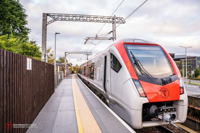
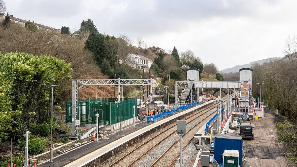
It's interesting to contrast South Wales Metro Project's priorities (electrification and basic stations accessibility) with Ottawa's Trillium line modernization (faregates and architectural features).
June 7, 2025 at 6:54 PM
It's interesting to contrast South Wales Metro Project's priorities (electrification and basic stations accessibility) with Ottawa's Trillium line modernization (faregates and architectural features).
Reposted by liam o’connell
new S(ubstack)-Bahn post: in the 1960s, Paris saw major ridership drops in its Metro and buses and rising deficits. so did every major French city. the head urban planner of Paris warned of a transit "catastrophe."
how did France rescue its public transit?
www.substack-bahn.net/p/how-france...
how did France rescue its public transit?
www.substack-bahn.net/p/how-france...
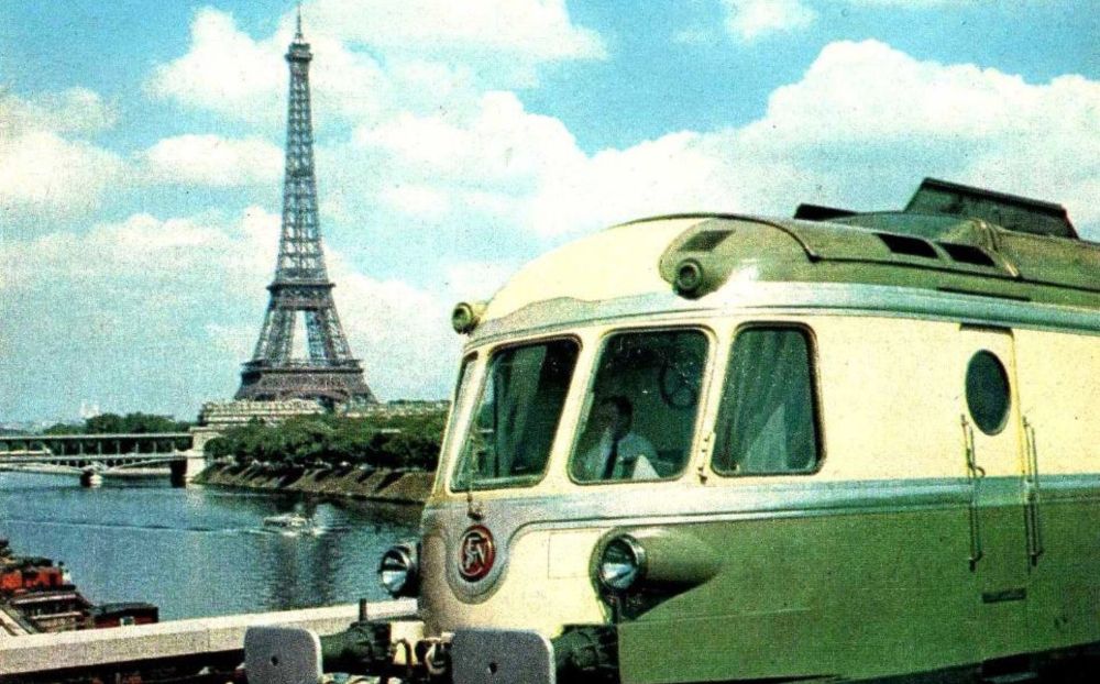
How France Saved its Public Transit from Catastrophe
One simple trick to revive a system in death spiral
www.substack-bahn.net
May 25, 2025 at 3:58 PM
new S(ubstack)-Bahn post: in the 1960s, Paris saw major ridership drops in its Metro and buses and rising deficits. so did every major French city. the head urban planner of Paris warned of a transit "catastrophe."
how did France rescue its public transit?
www.substack-bahn.net/p/how-france...
how did France rescue its public transit?
www.substack-bahn.net/p/how-france...
Reposted by liam o’connell
Did the Federal DOT just accidentally file a letter containing legal advice from the DOJ, instead of a letter addressed to the Judge, in the MTA v Duffy case?
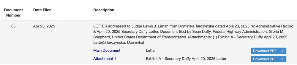
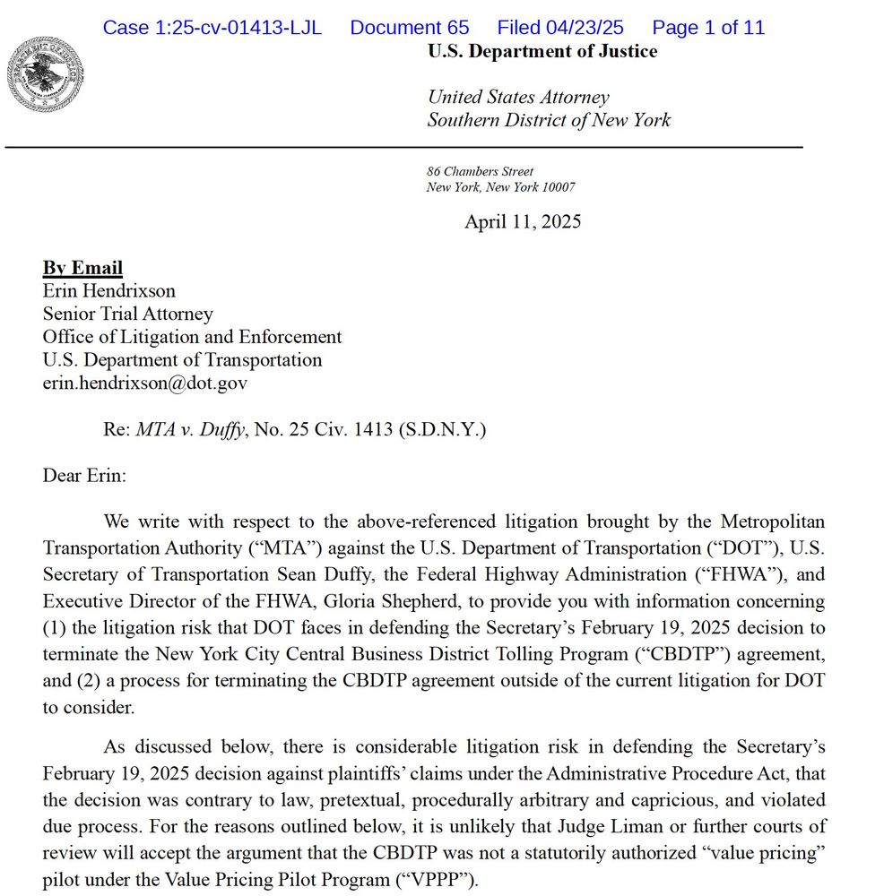
April 24, 2025 at 1:22 AM
Did the Federal DOT just accidentally file a letter containing legal advice from the DOJ, instead of a letter addressed to the Judge, in the MTA v Duffy case?