


Lichenstone Geo
@lichenstone.bsky.social
Robbie Austrums
#Geoscience - #GIS - #Archaeology
Anomaly GeoSurvey Software for #Geophysics
Worcester UK - www.lichenstone.com
#Geoscience - #GIS - #Archaeology
Anomaly GeoSurvey Software for #Geophysics
Worcester UK - www.lichenstone.com
This video by Flint Dibble provides a near optimal blend of the calm dispassionate analysis and righteous swearing that the topic deserves.
In an hour (6:30 UK/2:30 EDT), I'll go live and discuss the NEW viral claims for megastructures existing up to 2km deep under the pyramids at Giza
We'll look at interdisciplinary evidence and how this conspiracy spread so quickly
youtube.com/live/BQMfGuK...
We'll look at interdisciplinary evidence and how this conspiracy spread so quickly
youtube.com/live/BQMfGuK...
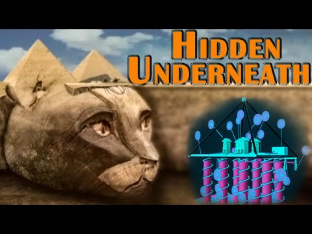
Megastructures under Giza Pyramids? ARCHAEOLOGY REWRITTEN or viral BS?
YouTube video by Archaeology with Flint Dibble
youtube.com
March 26, 2025 at 8:55 PM
This video by Flint Dibble provides a near optimal blend of the calm dispassionate analysis and righteous swearing that the topic deserves.
For anyone using Microsoft 365, and seeing what looks like a mandatory £25/yr price rise for AI tools, you can reject it by going to Account > Manage Subscriptions > Cancel Subscription > Then select Microsoft 365 Personal/Family *Classic*.
February 9, 2025 at 4:28 PM
For anyone using Microsoft 365, and seeing what looks like a mandatory £25/yr price rise for AI tools, you can reject it by going to Account > Manage Subscriptions > Cancel Subscription > Then select Microsoft 365 Personal/Family *Classic*.
Reposted by Lichenstone Geo
Happy "Microsoft trying to force CoPilot subs" day in the UK for all who celebrate.
(They just pinged me my renewal notice with it carefully worded to sound like a compulsory general price increase).
1) Go to your account page
2) Hit cancel
3) Change sub back.
(They just pinged me my renewal notice with it carefully worded to sound like a compulsory general price increase).
1) Go to your account page
2) Hit cancel
3) Change sub back.

February 6, 2025 at 9:55 AM
Happy "Microsoft trying to force CoPilot subs" day in the UK for all who celebrate.
(They just pinged me my renewal notice with it carefully worded to sound like a compulsory general price increase).
1) Go to your account page
2) Hit cancel
3) Change sub back.
(They just pinged me my renewal notice with it carefully worded to sound like a compulsory general price increase).
1) Go to your account page
2) Hit cancel
3) Change sub back.
Sad to see this beautiful #Worcester #canal -side weeping willow brought down by #stormdarragh. Still a lot of trunk remaining so I'll hope to see regrowth this spring.


December 8, 2024 at 2:53 PM
Sad to see this beautiful #Worcester #canal -side weeping willow brought down by #stormdarragh. Still a lot of trunk remaining so I'll hope to see regrowth this spring.
In London for @geolsoc.bsky.social NSGG Recent Advances in #Archaeology #Geophysics. Essential conference preparation in progress.

December 2, 2024 at 8:00 PM
In London for @geolsoc.bsky.social NSGG Recent Advances in #Archaeology #Geophysics. Essential conference preparation in progress.
Reposted by Lichenstone Geo

OK, here's my first starter pack. Honestly struggled a bit to find peeps! Pls let me know who's here that I'm missing so that I can grow this properly for drone mapping peeps! go.bsky.app/SXVsHzs
November 24, 2024 at 10:15 PM
OK, here's my first starter pack. Honestly struggled a bit to find peeps! Pls let me know who's here that I'm missing so that I can grow this properly for drone mapping peeps! go.bsky.app/SXVsHzs
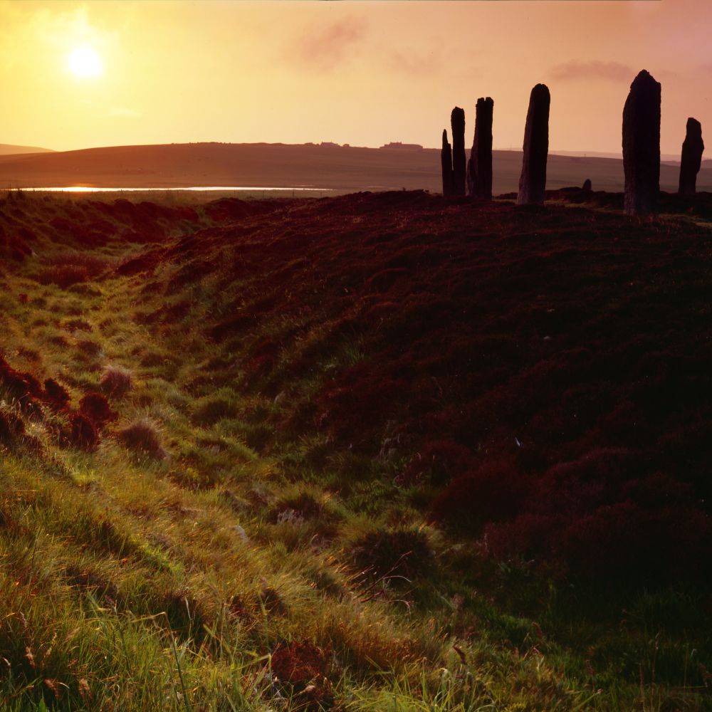
Ring of Brodgar, Orkney

November 25, 2024 at 12:11 AM
Ring of Brodgar, Orkney
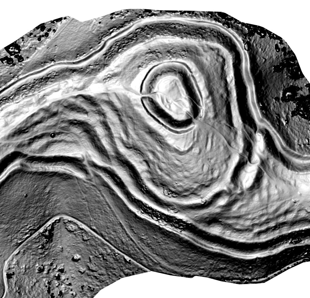
Visualizing terrain curvature can reveal and characterize subtle #archaeology features on steep ground.
This is a drone #photogrammetry survey of British Camp #hillfort on the #Malvern Hills. Red is convexity, blue is concavity, greyscale is steepness. Created using #QGIS and other #osgeo tools.
This is a drone #photogrammetry survey of British Camp #hillfort on the #Malvern Hills. Red is convexity, blue is concavity, greyscale is steepness. Created using #QGIS and other #osgeo tools.


November 21, 2024 at 6:53 PM
Visualizing terrain curvature can reveal and characterize subtle #archaeology features on steep ground.
This is a drone #photogrammetry survey of British Camp #hillfort on the #Malvern Hills. Red is convexity, blue is concavity, greyscale is steepness. Created using #QGIS and other #osgeo tools.
This is a drone #photogrammetry survey of British Camp #hillfort on the #Malvern Hills. Red is convexity, blue is concavity, greyscale is steepness. Created using #QGIS and other #osgeo tools.
Reposted by Lichenstone Geo
November 13, 2024 at 1:53 PM
Reposted by Lichenstone Geo

Hi Bluesky friends! If you're interested in digital archaeology, I've put together a list of folks in the field to follow. If you're an archaeologist who posts about digital tools, techniques, or projects and want to be included, just let me know, and I'll add you.
go.bsky.app/AHnKjhD
go.bsky.app/AHnKjhD
November 10, 2024 at 1:29 PM
Hi Bluesky friends! If you're interested in digital archaeology, I've put together a list of folks in the field to follow. If you're an archaeologist who posts about digital tools, techniques, or projects and want to be included, just let me know, and I'll add you.
go.bsky.app/AHnKjhD
go.bsky.app/AHnKjhD
Here's a little experiment on using data science to accentuate subtle colour differences between archaeological features.
Decorrelation stretch is a statistical method that aims to identify and remove covariance between colour components, increasing the visual separation of different deposits.
Decorrelation stretch is a statistical method that aims to identify and remove covariance between colour components, increasing the visual separation of different deposits.

November 21, 2024 at 12:10 PM
Here's a little experiment on using data science to accentuate subtle colour differences between archaeological features.
Decorrelation stretch is a statistical method that aims to identify and remove covariance between colour components, increasing the visual separation of different deposits.
Decorrelation stretch is a statistical method that aims to identify and remove covariance between colour components, increasing the visual separation of different deposits.