


Low Orbit Tourist 🌍📷
@loworbittourist.bsky.social
Google Earth is my copilot. Pictures of places I've never been. Hi-res / 4k on tumblr
@LowOrbitTourist on Instagram
@[email protected]
https://loworbittourist.tumblr.com/
@LowOrbitTourist on Instagram
@[email protected]
https://loworbittourist.tumblr.com/
Pinned
Since there are lots of new people on Bluesky, here's a reintroduction :
Low Orbit Tourist, since 2016 I'm looking for cool satellite imagery on Google Earth, both natural and human altered/made. All of them are available in 4K/HD
Here is a few example, thanks in advance for the reposts !
Low Orbit Tourist, since 2016 I'm looking for cool satellite imagery on Google Earth, both natural and human altered/made. All of them are available in 4K/HD
Here is a few example, thanks in advance for the reposts !
Reposted by Low Orbit Tourist 🌍📷
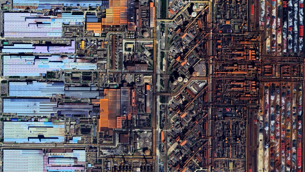
Cimetière Montparnasse - Paris - France
🌍 : maps.app.goo.gl/5JbkRtWM1DGA...
4K link : i.imgur.com/bUM8HhS.jpeg
🌍 : maps.app.goo.gl/5JbkRtWM1DGA...
4K link : i.imgur.com/bUM8HhS.jpeg

November 23, 2025 at 11:37 AM
Cimetière Montparnasse - Paris - France
🌍 : maps.app.goo.gl/5JbkRtWM1DGA...
4K link : i.imgur.com/bUM8HhS.jpeg
🌍 : maps.app.goo.gl/5JbkRtWM1DGA...
4K link : i.imgur.com/bUM8HhS.jpeg
Cimetière Montparnasse - Paris - France
🌍 : maps.app.goo.gl/5JbkRtWM1DGA...
4K link : i.imgur.com/bUM8HhS.jpeg
🌍 : maps.app.goo.gl/5JbkRtWM1DGA...
4K link : i.imgur.com/bUM8HhS.jpeg
November 23, 2025 at 11:37 AM
Cimetière Montparnasse - Paris - France
🌍 : maps.app.goo.gl/5JbkRtWM1DGA...
4K link : i.imgur.com/bUM8HhS.jpeg
🌍 : maps.app.goo.gl/5JbkRtWM1DGA...
4K link : i.imgur.com/bUM8HhS.jpeg
Reposted by Low Orbit Tourist 🌍📷

Naples, FL 🇺🇸

November 19, 2025 at 4:01 PM
Naples, FL 🇺🇸
Reposted by Low Orbit Tourist 🌍📷

November 15, 2025 at 11:06 AM
November 15, 2025 at 11:06 AM
Reposted by Low Orbit Tourist 🌍📷
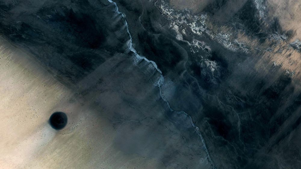
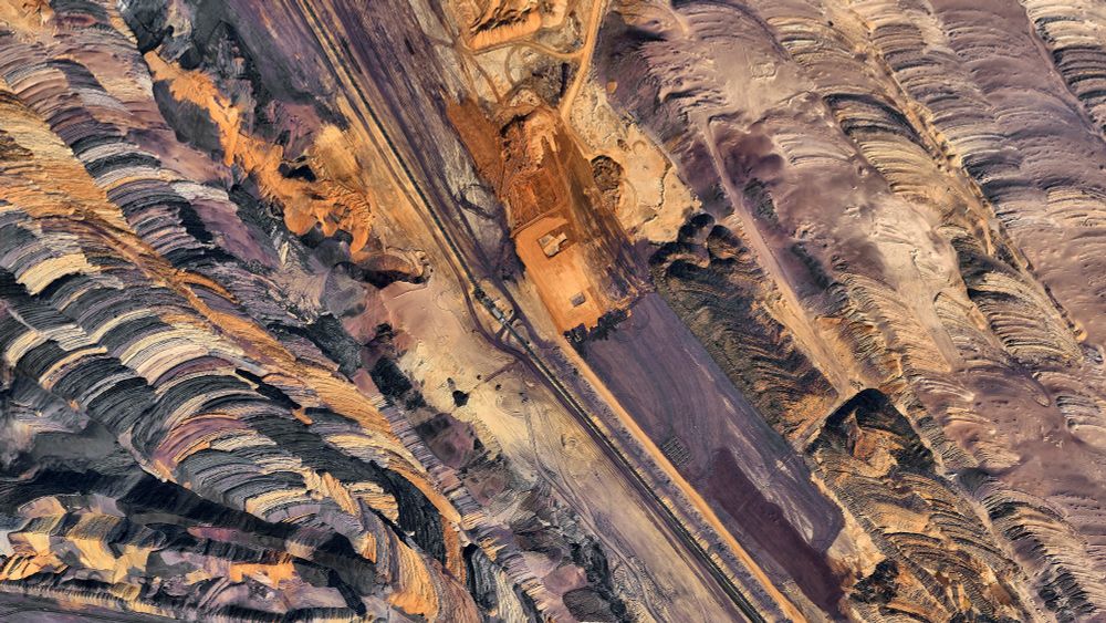
Details of the Garzweiler surface mine - Germany
🌍 : maps.app.goo.gl/JJbyiLQvkJ8R...
4K link : imgur.com/a/h5r35F5
🌍 : maps.app.goo.gl/JJbyiLQvkJ8R...
4K link : imgur.com/a/h5r35F5


November 6, 2025 at 8:09 PM
Details of the Garzweiler surface mine - Germany
🌍 : maps.app.goo.gl/JJbyiLQvkJ8R...
4K link : imgur.com/a/h5r35F5
🌍 : maps.app.goo.gl/JJbyiLQvkJ8R...
4K link : imgur.com/a/h5r35F5
and in 2025 even, are those people serious ?

November 9, 2025 at 11:04 PM
and in 2025 even, are those people serious ?
Details of the Garzweiler surface mine - Germany
🌍 : maps.app.goo.gl/JJbyiLQvkJ8R...
4K link : imgur.com/a/h5r35F5
🌍 : maps.app.goo.gl/JJbyiLQvkJ8R...
4K link : imgur.com/a/h5r35F5
November 6, 2025 at 8:09 PM
Details of the Garzweiler surface mine - Germany
🌍 : maps.app.goo.gl/JJbyiLQvkJ8R...
4K link : imgur.com/a/h5r35F5
🌍 : maps.app.goo.gl/JJbyiLQvkJ8R...
4K link : imgur.com/a/h5r35F5
Reposted by Low Orbit Tourist 🌍📷
Factory Butte - Utah - USA
🌎 : maps.app.goo.gl/G6YVCv5fE8pN...
4K link : i.imgur.com/08vSUM2.jpeg
This one is an experiment around processing, by combining satellite pictures from 2012 and 2025 and playing with fusion masks, the colors are very much artificial but the rest is not.
🌎 : maps.app.goo.gl/G6YVCv5fE8pN...
4K link : i.imgur.com/08vSUM2.jpeg
This one is an experiment around processing, by combining satellite pictures from 2012 and 2025 and playing with fusion masks, the colors are very much artificial but the rest is not.

October 31, 2025 at 12:13 PM
Factory Butte - Utah - USA
🌎 : maps.app.goo.gl/G6YVCv5fE8pN...
4K link : i.imgur.com/08vSUM2.jpeg
This one is an experiment around processing, by combining satellite pictures from 2012 and 2025 and playing with fusion masks, the colors are very much artificial but the rest is not.
🌎 : maps.app.goo.gl/G6YVCv5fE8pN...
4K link : i.imgur.com/08vSUM2.jpeg
This one is an experiment around processing, by combining satellite pictures from 2012 and 2025 and playing with fusion masks, the colors are very much artificial but the rest is not.
October 31, 2025 at 12:13 PM
Factory Butte - Utah - USA
🌎 : maps.app.goo.gl/G6YVCv5fE8pN...
4K link : i.imgur.com/08vSUM2.jpeg
This one is an experiment around processing, by combining satellite pictures from 2012 and 2025 and playing with fusion masks, the colors are very much artificial but the rest is not.
🌎 : maps.app.goo.gl/G6YVCv5fE8pN...
4K link : i.imgur.com/08vSUM2.jpeg
This one is an experiment around processing, by combining satellite pictures from 2012 and 2025 and playing with fusion masks, the colors are very much artificial but the rest is not.
Reposted by Low Orbit Tourist 🌍📷

Ganges Chasma Rim (natural color) - Mars Reconnaissance Orbiter - From Aster Cowart (terrasabaea.bsky.social) - https://flic.kr/p/2hFSFbW

October 30, 2025 at 3:00 AM
Ganges Chasma Rim (natural color) - Mars Reconnaissance Orbiter - From Aster Cowart (terrasabaea.bsky.social) - https://flic.kr/p/2hFSFbW
Reposted by Low Orbit Tourist 🌍📷

Hurricane #Melissa update: imagery from dawn until about 2:00 pm local time, when the eye was squarely over Jamaica. At landfall sustained winds were about 185 mph, making Melissa one of the strongest hurricanes ever.
October 28, 2025 at 8:00 PM
Hurricane #Melissa update: imagery from dawn until about 2:00 pm local time, when the eye was squarely over Jamaica. At landfall sustained winds were about 185 mph, making Melissa one of the strongest hurricanes ever.
Reposted by Low Orbit Tourist 🌍📷

Río Tapiche, une cartographie sonore des méandres d'un sous-affluent de l’Amazone dans la partie péruvienne du bassin amazonien, composée à partir d’enregistrements de terrain réalisés en 2019.
Le lien vers la carte sonore :
www.jeremiefaivre.eu/sonore/tapiche
#fieldrecording
Le lien vers la carte sonore :
www.jeremiefaivre.eu/sonore/tapiche
#fieldrecording

February 18, 2024 at 9:42 AM
Río Tapiche, une cartographie sonore des méandres d'un sous-affluent de l’Amazone dans la partie péruvienne du bassin amazonien, composée à partir d’enregistrements de terrain réalisés en 2019.
Le lien vers la carte sonore :
www.jeremiefaivre.eu/sonore/tapiche
#fieldrecording
Le lien vers la carte sonore :
www.jeremiefaivre.eu/sonore/tapiche
#fieldrecording
Reposted by Low Orbit Tourist 🌍📷
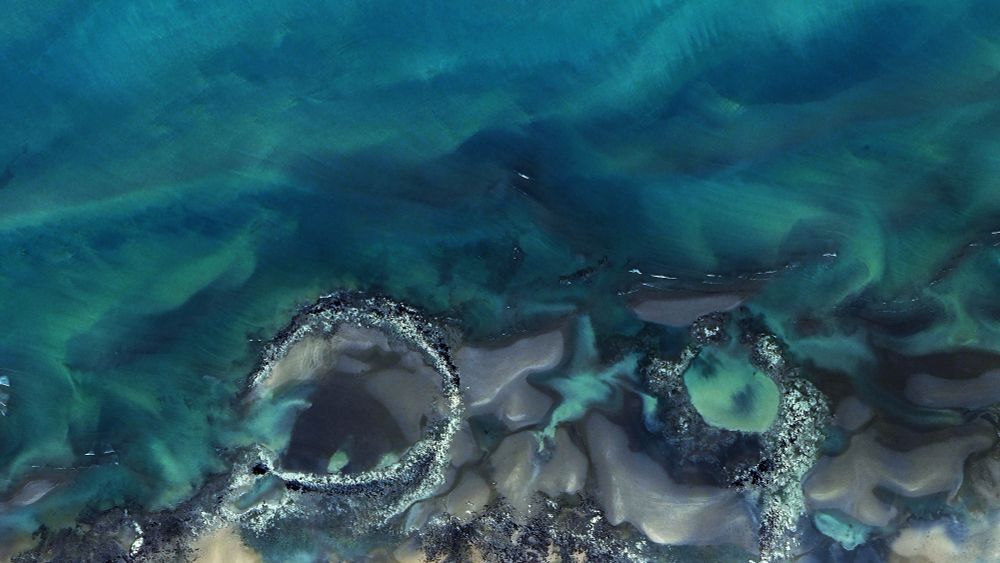
Details of the North Australian coast - Australia
🌏 : maps.app.goo.gl/g11PYgzqDXb2...
4k link : imgur.com/a/pyRPLft
🌏 : maps.app.goo.gl/g11PYgzqDXb2...
4k link : imgur.com/a/pyRPLft


October 24, 2025 at 6:16 PM
Details of the North Australian coast - Australia
🌏 : maps.app.goo.gl/g11PYgzqDXb2...
4k link : imgur.com/a/pyRPLft
🌏 : maps.app.goo.gl/g11PYgzqDXb2...
4k link : imgur.com/a/pyRPLft
Reposted by Low Orbit Tourist 🌍📷

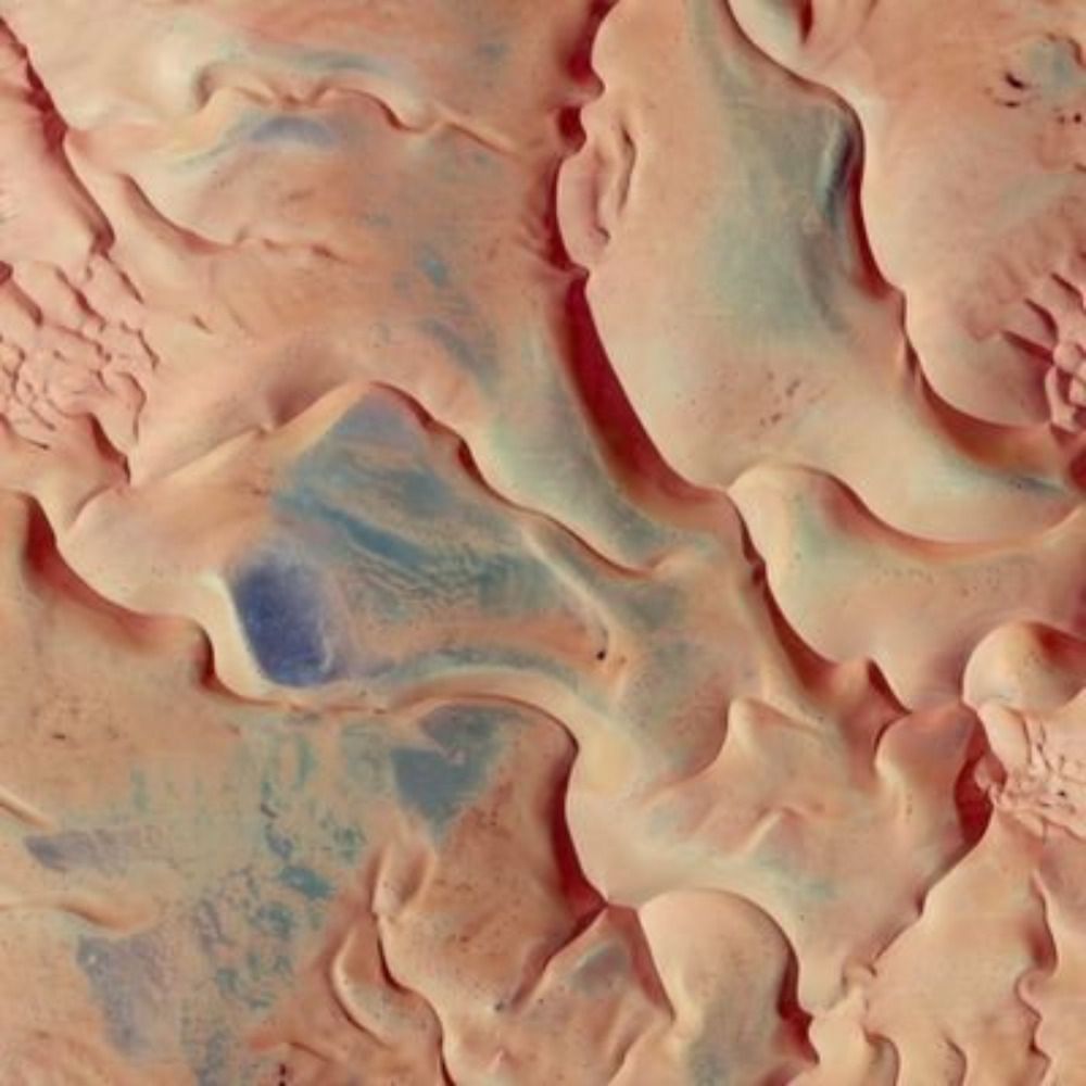
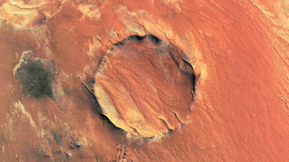
HiPOD: A Song of Ice and More Ice
This stunning image shows part of the South Polar residual ice cap, a term that refers to ice that lingers well past a seasonal change. Our science goal here is to look for any changes in the ice cap.
https://uahirise.org/hipod/ESP_076435_0940
#Mars #science #NASA
This stunning image shows part of the South Polar residual ice cap, a term that refers to ice that lingers well past a seasonal change. Our science goal here is to look for any changes in the ice cap.
https://uahirise.org/hipod/ESP_076435_0940
#Mars #science #NASA


October 24, 2025 at 6:19 PM
HiPOD: A Song of Ice and More Ice
This stunning image shows part of the South Polar residual ice cap, a term that refers to ice that lingers well past a seasonal change. Our science goal here is to look for any changes in the ice cap.
https://uahirise.org/hipod/ESP_076435_0940
#Mars #science #NASA
This stunning image shows part of the South Polar residual ice cap, a term that refers to ice that lingers well past a seasonal change. Our science goal here is to look for any changes in the ice cap.
https://uahirise.org/hipod/ESP_076435_0940
#Mars #science #NASA
Details of the North Australian coast - Australia
🌏 : maps.app.goo.gl/g11PYgzqDXb2...
4k link : imgur.com/a/pyRPLft
🌏 : maps.app.goo.gl/g11PYgzqDXb2...
4k link : imgur.com/a/pyRPLft
October 24, 2025 at 6:16 PM
Details of the North Australian coast - Australia
🌏 : maps.app.goo.gl/g11PYgzqDXb2...
4k link : imgur.com/a/pyRPLft
🌏 : maps.app.goo.gl/g11PYgzqDXb2...
4k link : imgur.com/a/pyRPLft
Reposted by Low Orbit Tourist 🌍📷

October 17, 2025 at 4:44 PM
October 17, 2025 at 4:44 PM
Reposted by Low Orbit Tourist 🌍📷

October 10, 2025 at 7:56 AM
Reposted by Low Orbit Tourist 🌍📷
✨One year ago, on the starry night 🌌 from October 10th to 11th, 2024, we had the chance to contemplate the magic of the Northern Lights from France✨
#nothernlights #aurora #auroraborealis #photography #astrophotography
@vincentledvina.bsky.social
@astropierre.com
@ericlagadec.bsky.social
#nothernlights #aurora #auroraborealis #photography #astrophotography
@vincentledvina.bsky.social
@astropierre.com
@ericlagadec.bsky.social


October 10, 2025 at 8:57 AM
✨One year ago, on the starry night 🌌 from October 10th to 11th, 2024, we had the chance to contemplate the magic of the Northern Lights from France✨
#nothernlights #aurora #auroraborealis #photography #astrophotography
@vincentledvina.bsky.social
@astropierre.com
@ericlagadec.bsky.social
#nothernlights #aurora #auroraborealis #photography #astrophotography
@vincentledvina.bsky.social
@astropierre.com
@ericlagadec.bsky.social
October 10, 2025 at 7:56 AM
Reposted by Low Orbit Tourist 🌍📷

Reposted by Low Orbit Tourist 🌍📷

September 28, 2025 at 1:04 PM
Reposted by Low Orbit Tourist 🌍📷
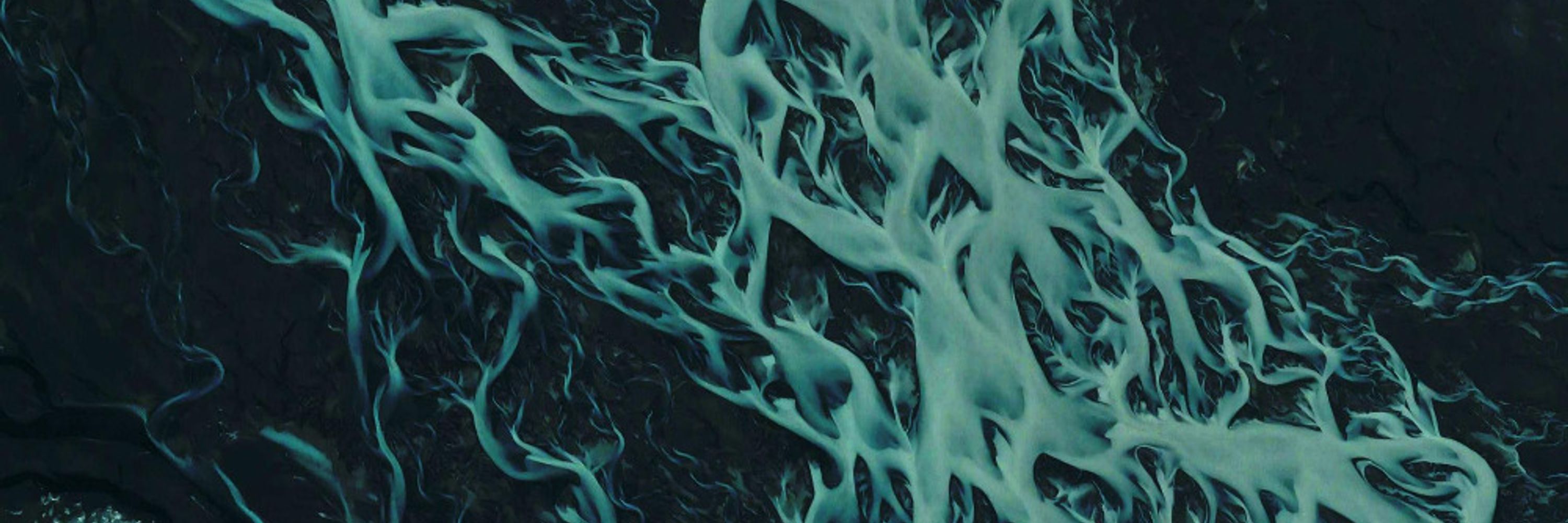
The amazingly astonishing Assiniboine River, Manitoba, Canada, again.

September 30, 2025 at 1:06 AM
The amazingly astonishing Assiniboine River, Manitoba, Canada, again.
Reposted by Low Orbit Tourist 🌍📷
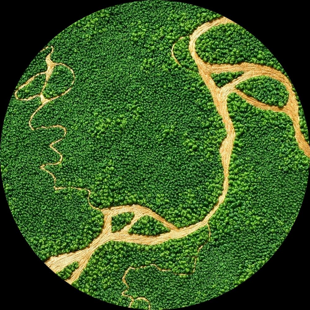
A past embroidery commission I forgot to share on here... an aerial view of an equestrian farm somewhere in America! This was such a lovely landscape is embroider: the horse fields and red farm houses are so pleasing :) such a soothing green landscape 💚

September 29, 2025 at 2:49 PM
A past embroidery commission I forgot to share on here... an aerial view of an equestrian farm somewhere in America! This was such a lovely landscape is embroider: the horse fields and red farm houses are so pleasing :) such a soothing green landscape 💚