


Eilat to Johannesburg via Nairobi on these two chartered flights: fr24.com/data/flights... and fr24.com/data/flights... www.theguardian.com/world/2025/n...


November 15, 2025 at 11:09 AM
Eilat to Johannesburg via Nairobi on these two chartered flights: fr24.com/data/flights... and fr24.com/data/flights... www.theguardian.com/world/2025/n...
playing basketball in Damascus google.com/maps?ll=33.5...


November 9, 2025 at 12:06 AM
playing basketball in Damascus google.com/maps?ll=33.5...
Israeli troops also took over the tower overlooking the area that once was a forest about 150m north of their base in Jubata al-Khashab google.com/maps?ll=33.2...


October 20, 2025 at 8:35 PM
Israeli troops also took over the tower overlooking the area that once was a forest about 150m north of their base in Jubata al-Khashab google.com/maps?ll=33.2...
Bashar's luxurious residence in exile in Moscow maps.app.goo.gl/Lzt6HADLALix... where "Assad's family owns around 20 apartments in the left tower" according to @zeit.de archive.is/fh5IX


October 11, 2025 at 7:41 PM
Bashar's luxurious residence in exile in Moscow maps.app.goo.gl/Lzt6HADLALix... where "Assad's family owns around 20 apartments in the left tower" according to @zeit.de archive.is/fh5IX
in addition to the pretty 3D animations this kind of textbook propaganda also applies to misleading maps, diligently labeled as "illustrations", which the IDF publishes with the same goal of making the public believe they were showing something real

NEW: Since October 2023, the IDF Spokesperson's Unit has released dozens of 3D animations illustrating alleged Hamas, Hezbollah, and Iranian sites
The style is now unmistakable: satellite zoom-ins, black & white wireframes, and red-textured houses - a new visual language of war
The style is now unmistakable: satellite zoom-ins, black & white wireframes, and red-textured houses - a new visual language of war
October 9, 2025 at 6:19 PM
in addition to the pretty 3D animations this kind of textbook propaganda also applies to misleading maps, diligently labeled as "illustrations", which the IDF publishes with the same goal of making the public believe they were showing something real
ten years ago today Russia started its campaign of airstrikes and lies in Syria in an attempt to save the Assad regime with a strike on Jaish Al-Izza in al-Lataminah google.com/maps?ll=35.3... claiming they had destroyed an ISIS HQ youtube.com/watch?v=hiA0...


September 30, 2025 at 5:29 PM
ten years ago today Russia started its campaign of airstrikes and lies in Syria in an attempt to save the Assad regime with a strike on Jaish Al-Izza in al-Lataminah google.com/maps?ll=35.3... claiming they had destroyed an ISIS HQ youtube.com/watch?v=hiA0...
"Tel Kurdi" chemical weapons production facility (CWPF) as declared by the Aassad regime and destroyed on 23 Jun 2018, reported by the OPCW ("all declared buildings had been razed to ground level and all debris removed") opcw.org/sites/defaul... [pdf] google.com/maps?ll=33.5...


September 26, 2025 at 4:38 PM
"Tel Kurdi" chemical weapons production facility (CWPF) as declared by the Aassad regime and destroyed on 23 Jun 2018, reported by the OPCW ("all declared buildings had been razed to ground level and all debris removed") opcw.org/sites/defaul... [pdf] google.com/maps?ll=33.5...
it seems the Israeli govt is free to support the humanitarian corridors that are already established by WFP/ICRC if it cared about the Druze in Syria www.reuters.com/world/middle...

Exclusive: Israel-Syria talks hit snag over humanitarian corridor, sources say
Efforts to reach a security pact between Syria and Israel have hit a last-minute snag over Israel's demand that it be allowed to open a "humanitarian corridor" to Syria's southern province of Sweida, four sources familiar with the talks said.
www.reuters.com
September 26, 2025 at 2:08 PM
it seems the Israeli govt is free to support the humanitarian corridors that are already established by WFP/ICRC if it cared about the Druze in Syria www.reuters.com/world/middle...
Russian field hospital in Homs since 2021 google.com/maps?ll=34.7... disappeared around 20 May 2025

September 23, 2025 at 8:04 PM
Russian field hospital in Homs since 2021 google.com/maps?ll=34.7... disappeared around 20 May 2025
Reposted by Samir

“In a quote that was not on the recording but was cited by Ynet, Halevi appeared to suggest that the main importance of Israel’s military lawyers was to convince the outside world of the legality of the IDF’s actions.” www.theguardian.com/world/2025/s...

‘We took the gloves off’: ex-IDF chief confirms Gaza casualties over 200,000
Retired general Herzi Halevi says ‘not once’ had legal advice constrained Israel’s military decisions in the strip
www.theguardian.com
September 12, 2025 at 8:53 PM
“In a quote that was not on the recording but was cited by Ynet, Halevi appeared to suggest that the main importance of Israel’s military lawyers was to convince the outside world of the legality of the IDF’s actions.” www.theguardian.com/world/2025/s...
Aframax tanker "Nissos Christiana" anchored near the oil terminal in Tartus link.dataspace.copernicus.eu/p46j to load the first cargo of Syrian crude oil since the lifting of sanctions (~0.5mbbl) archive.is/kBtVB

August 30, 2025 at 2:44 PM
Aframax tanker "Nissos Christiana" anchored near the oil terminal in Tartus link.dataspace.copernicus.eu/p46j to load the first cargo of Syrian crude oil since the lifting of sanctions (~0.5mbbl) archive.is/kBtVB
Israeli airstrikes on the military base east of al-Kiswah last night google.com/maps?ll=33.3... aimed to close off the area by targeting roads and access points to the base and the hilltop

August 28, 2025 at 7:29 PM
Israeli airstrikes on the military base east of al-Kiswah last night google.com/maps?ll=33.3... aimed to close off the area by targeting roads and access points to the base and the hilltop
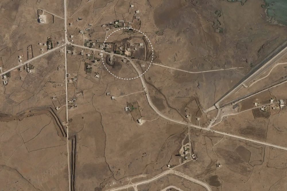
geolocation of the building in Tarnaja village google.com/maps?ll=33.2... that was shelled by the IDF today killing a civilian sana.sy/locals/22716...

August 26, 2025 at 6:50 PM
geolocation of the building in Tarnaja village google.com/maps?ll=33.2... that was shelled by the IDF today killing a civilian sana.sy/locals/22716...
geolocation of the building that was raided last night google.com/maps?ll=36.3... in Atmeh


August 20, 2025 at 9:31 PM
geolocation of the building that was raided last night google.com/maps?ll=36.3... in Atmeh
human remains were found among the rubble geolocated in the Karam Zaytun neighborhood of Homs google.com/maps?ll=34.7...


August 10, 2025 at 5:02 PM
human remains were found among the rubble geolocated in the Karam Zaytun neighborhood of Homs google.com/maps?ll=34.7...
Zaiter's burning Cadillac geolocated in Baalbek google.com/maps?ll=34.0...


August 6, 2025 at 5:34 PM
Zaiter's burning Cadillac geolocated in Baalbek google.com/maps?ll=34.0...
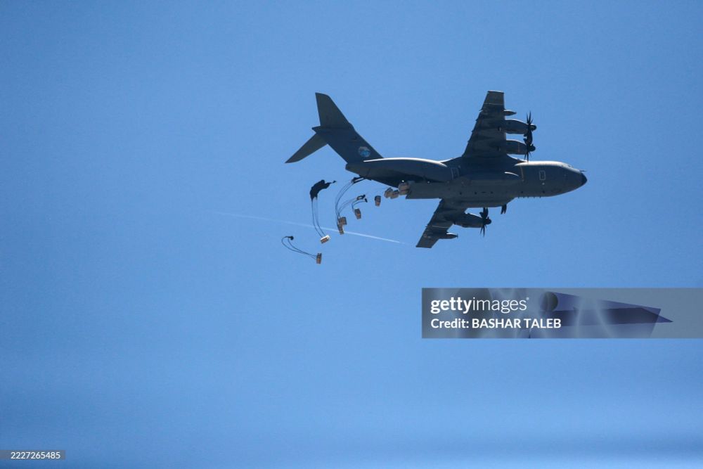
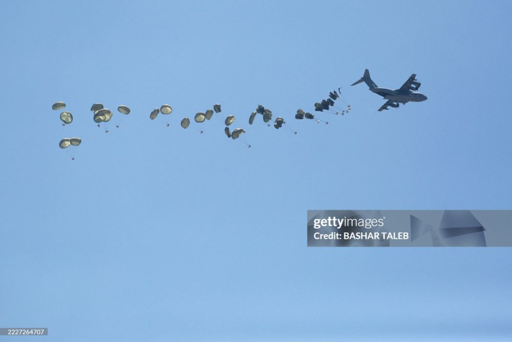
German Air Force A400M conducting an airdrop of humanitarian aid over northern Gaza today gettyimages.com/detail/22272...
August 1, 2025 at 7:57 PM
German Air Force A400M conducting an airdrop of humanitarian aid over northern Gaza today gettyimages.com/detail/22272...
remains of a tank destroyed between 27 and 29 Oct 2017 on the side of the road halfway between Damascus and Palmyra www.google.com/maps?ll=33.9...


July 28, 2025 at 6:37 PM
remains of a tank destroyed between 27 and 29 Oct 2017 on the side of the road halfway between Damascus and Palmyra www.google.com/maps?ll=33.9...
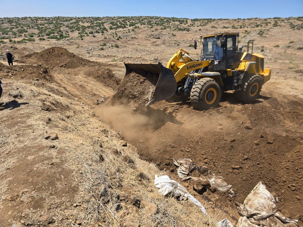
geolocation of a mass grave google.com/maps?ll=32.6... southeast of Suwayda
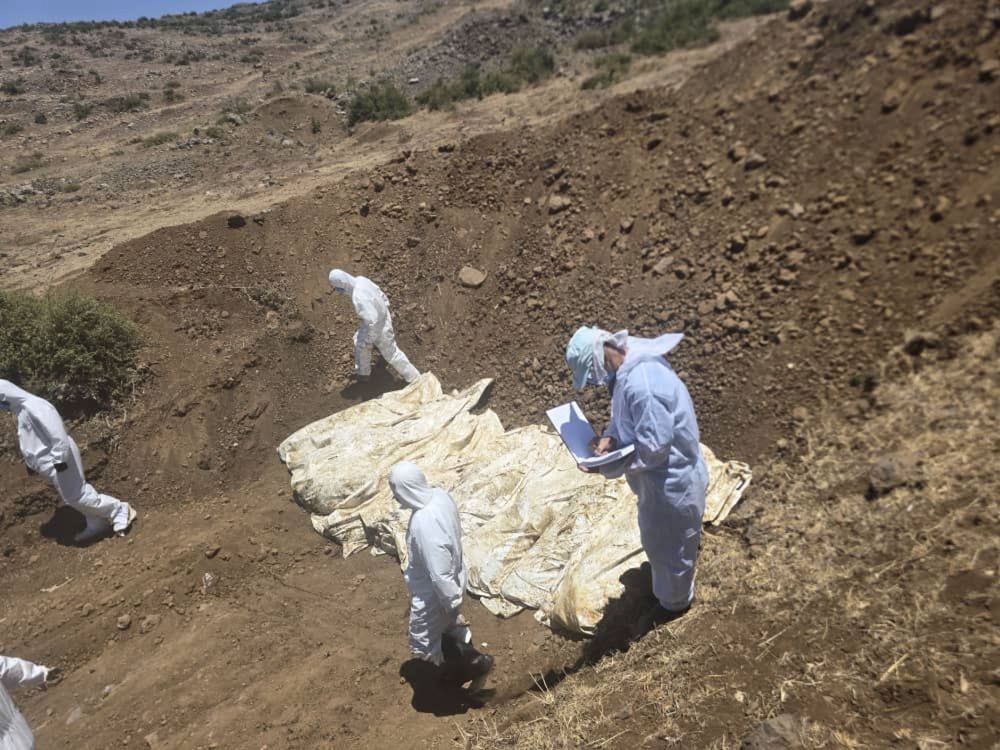
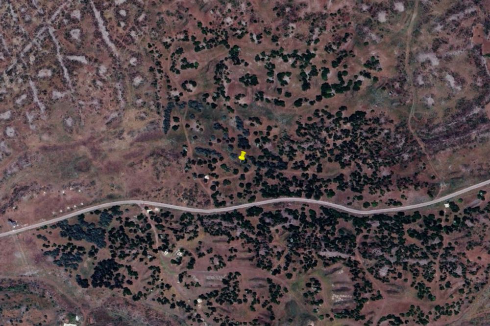
July 25, 2025 at 6:34 PM
geolocation of a mass grave google.com/maps?ll=32.6... southeast of Suwayda
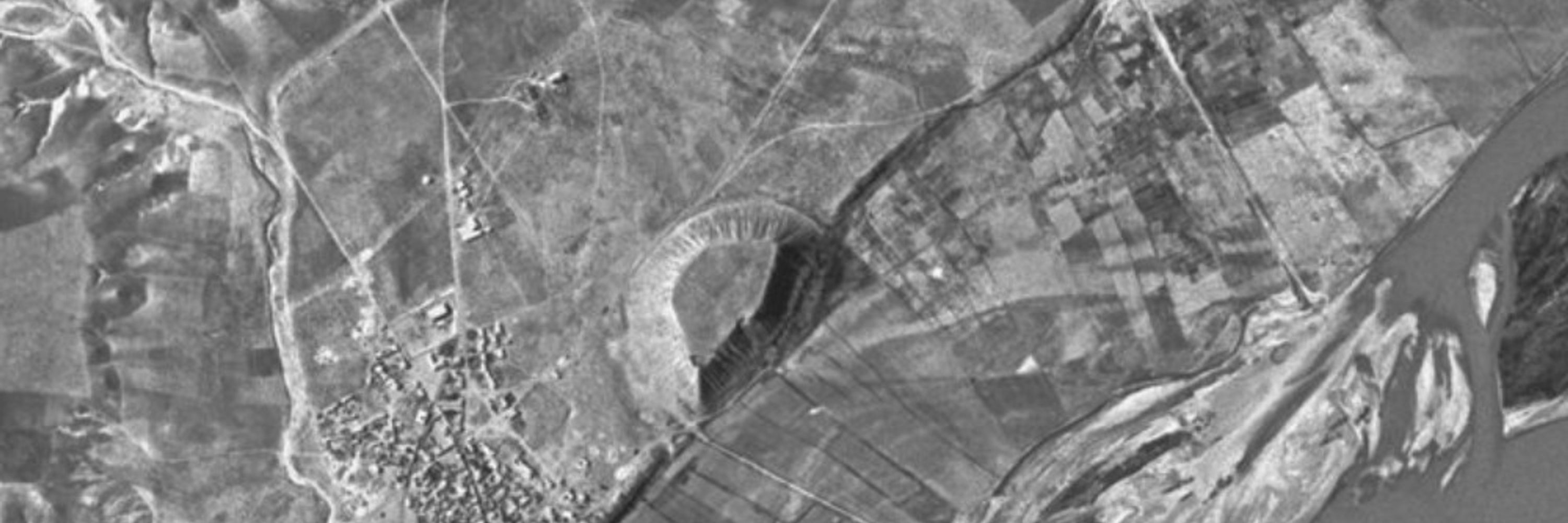
scorched-earth policy of complete and total destruction visible from space (unpaywalled archive.is/rvmJb)
July 23, 2025 at 7:01 PM
scorched-earth policy of complete and total destruction visible from space (unpaywalled archive.is/rvmJb)
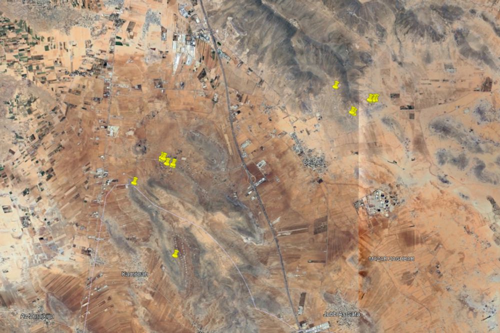
Israeli airstrikes in southern Syria between 14 and 17 Jul 2025 mapped from Sentinel-2 satellite images and geolocated footage (h/t @elkangoo.bsky.social)
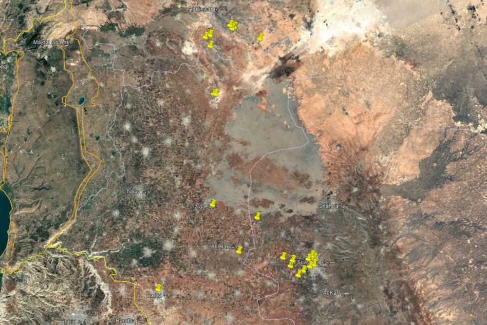
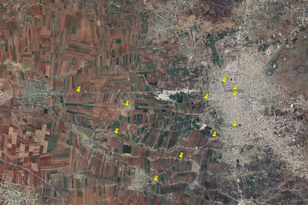
July 20, 2025 at 10:54 PM
Israeli airstrikes in southern Syria between 14 and 17 Jul 2025 mapped from Sentinel-2 satellite images and geolocated footage (h/t @elkangoo.bsky.social)
Israeli troops geolocated near the archaeological site of Burqush google.com/maps?ll=33.4... ~25km west of Damascus idf.il/302272
July 13, 2025 at 6:32 PM
Israeli troops geolocated near the archaeological site of Burqush google.com/maps?ll=33.4... ~25km west of Damascus idf.il/302272
IDF fortifications and roadblocks next to al-Mantara dam in Quneitra google.com/maps?ll=33.1... newlinesmag.com/spotlight/is...
July 13, 2025 at 12:27 PM
IDF fortifications and roadblocks next to al-Mantara dam in Quneitra google.com/maps?ll=33.1... newlinesmag.com/spotlight/is...
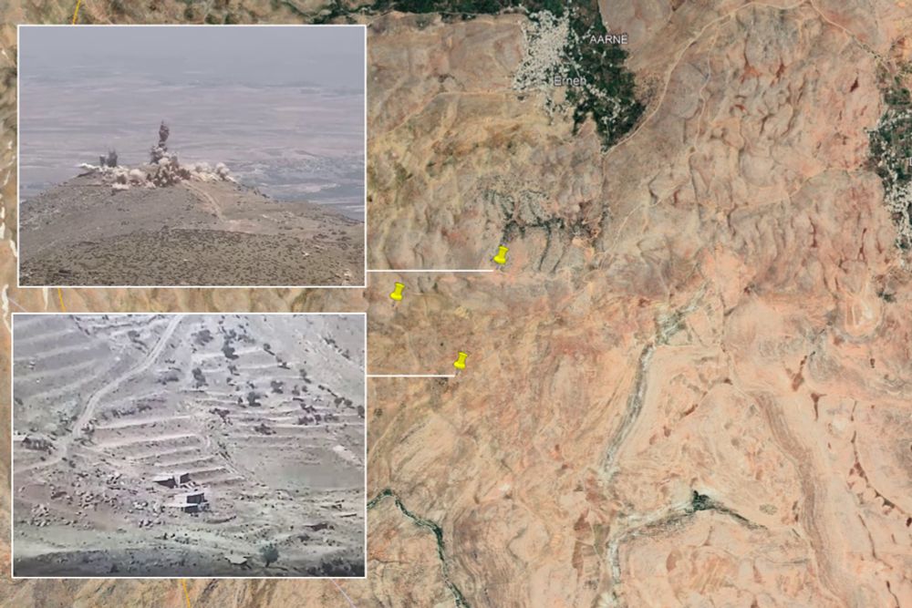
IDF demolished some farms google.com/maps?ll=33.3... and Assad regime military outposts in Syria which they deemed a threat to Israel on 10/11 June 2025 youtube.com/watch?v=kX_E... www.idf.il/301235
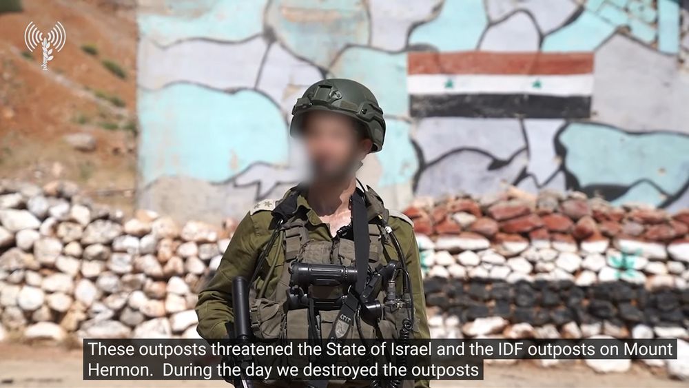
July 6, 2025 at 4:12 PM
IDF demolished some farms google.com/maps?ll=33.3... and Assad regime military outposts in Syria which they deemed a threat to Israel on 10/11 June 2025 youtube.com/watch?v=kX_E... www.idf.il/301235
geolocation of the Israeli drone strike on a car on the highway just south of Beirut airport google.com/maps?ll=33.7...

July 3, 2025 at 6:38 PM
geolocation of the Israeli drone strike on a car on the highway just south of Beirut airport google.com/maps?ll=33.7...