


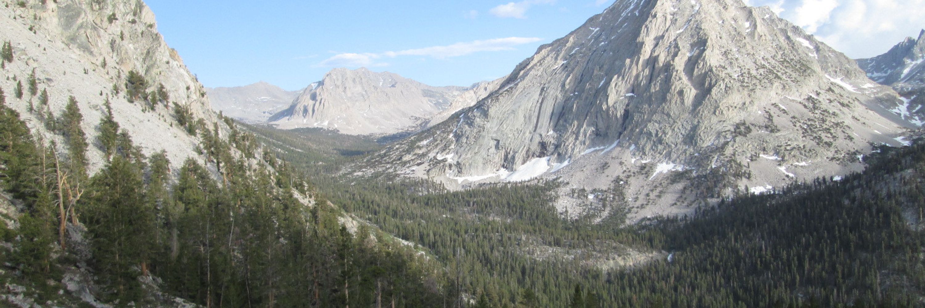

Postholer - Hiking & GIS
@postholer.com
GIS, Interactive & Printed Trail Maps, Data Books, Trip Planners, Snow, Wildfires, Gear Lists, Open Source, GDAL Evangelist. https://www.postholer.com, https://cloudnativemaps.com, https://femafhz.com
Anyone notice a massive increase of bad internet traffic coming from South America over the last few months?
Here's looking at you #Brazil:
www.femafhz.com/map/-17.9518...
#gis #osint
Here's looking at you #Brazil:
www.femafhz.com/map/-17.9518...
#gis #osint


November 18, 2025 at 9:46 PM
Anyone notice a massive increase of bad internet traffic coming from South America over the last few months?
Here's looking at you #Brazil:
www.femafhz.com/map/-17.9518...
#gis #osint
Here's looking at you #Brazil:
www.femafhz.com/map/-17.9518...
#gis #osint


November 12, 2025 at 4:50 AM
Comparison of NBM QPF (precipitation) forecast model vs actual QPF amounts, for 2 events, Oct 24-27 and Nov 04-06 2025 along the California north coast. Consistency is an issue. @nws.noaa.gov #weather #california


November 7, 2025 at 7:07 PM
Comparison of NBM QPF (precipitation) forecast model vs actual QPF amounts, for 2 events, Oct 24-27 and Nov 04-06 2025 along the California north coast. Consistency is an issue. @nws.noaa.gov #weather #california
National Risk Index, Riverine Flooding - Expected Annual Loss Rate - National Percentile shown. Choose category by state, county or census tract #polygons.
www.femafhz.com/map/35.13787...
#30DayMapChallenge
www.femafhz.com/map/35.13787...
#30DayMapChallenge


November 3, 2025 at 7:49 PM
National Risk Index, Riverine Flooding - Expected Annual Loss Rate - National Percentile shown. Choose category by state, county or census tract #polygons.
www.femafhz.com/map/35.13787...
#30DayMapChallenge
www.femafhz.com/map/35.13787...
#30DayMapChallenge
Reposted by Postholer - Hiking & GIS
a century of glaciers melting 🧪🌐
November 3, 2025 at 5:21 PM
a century of glaciers melting 🧪🌐
Using PostGIS ST_LineInterpolatePoints to evenly get points from line features (roads) and ST_ClusterDBScan to get (mostly) non-overlapping points for road shields on interactive map.
Using only st_clusterdbscan for non-overlaping GNIS place names.
#30DayMapChallenge #points #postgis #leafletjs
Using only st_clusterdbscan for non-overlaping GNIS place names.
#30DayMapChallenge #points #postgis #leafletjs

November 1, 2025 at 3:52 AM
Using PostGIS ST_LineInterpolatePoints to evenly get points from line features (roads) and ST_ClusterDBScan to get (mostly) non-overlapping points for road shields on interactive map.
Using only st_clusterdbscan for non-overlaping GNIS place names.
#30DayMapChallenge #points #postgis #leafletjs
Using only st_clusterdbscan for non-overlaping GNIS place names.
#30DayMapChallenge #points #postgis #leafletjs

Reposted by Postholer - Hiking & GIS

The authors say it's a sign that renewables can keep up the pace with the growing appetite for electricity worldwide.

Renewables overtake coal as biggest global source of electricity
The authors say it's a sign that renewables can keep up the pace with the growing appetite for electricity worldwide.
l.euronews.com
October 8, 2025 at 12:40 AM
The authors say it's a sign that renewables can keep up the pace with the growing appetite for electricity worldwide.
State of California: 4th largest GDP in the *world*.
71% of the U.S. economy originates from blue states.
Red states are being *subsidized* by blue states.
What a complete embarrassment.
71% of the U.S. economy originates from blue states.
Red states are being *subsidized* by blue states.
What a complete embarrassment.
October 6, 2025 at 10:09 PM
State of California: 4th largest GDP in the *world*.
71% of the U.S. economy originates from blue states.
Red states are being *subsidized* by blue states.
What a complete embarrassment.
71% of the U.S. economy originates from blue states.
Red states are being *subsidized* by blue states.
What a complete embarrassment.

September 26, 2025 at 10:06 PM
Per the #PCTA:
"The Trump Administration this week formally announced its intention to roll back longstanding protections for Inventoried Roadless Areas in National Forests..."
www.pcta.org/2025/scrappi...
Map for all trails, layers->Protected Areas->Roadless Areas:
www.postholer.com/trail-maps
"The Trump Administration this week formally announced its intention to roll back longstanding protections for Inventoried Roadless Areas in National Forests..."
www.pcta.org/2025/scrappi...
Map for all trails, layers->Protected Areas->Roadless Areas:
www.postholer.com/trail-maps

September 5, 2025 at 5:37 PM
Per the #PCTA:
"The Trump Administration this week formally announced its intention to roll back longstanding protections for Inventoried Roadless Areas in National Forests..."
www.pcta.org/2025/scrappi...
Map for all trails, layers->Protected Areas->Roadless Areas:
www.postholer.com/trail-maps
"The Trump Administration this week formally announced its intention to roll back longstanding protections for Inventoried Roadless Areas in National Forests..."
www.pcta.org/2025/scrappi...
Map for all trails, layers->Protected Areas->Roadless Areas:
www.postholer.com/trail-maps

August 28, 2025 at 8:38 PM

August 20, 2025 at 4:43 PM
California, the 4th largest economy in the world, has a balanced budget, *without a deficit*.
Maybe the state isn't just a bunch of idiots after all?
x.com/GovPressOffi...
Maybe the state isn't just a bunch of idiots after all?
x.com/GovPressOffi...
August 17, 2025 at 7:27 PM
California, the 4th largest economy in the world, has a balanced budget, *without a deficit*.
Maybe the state isn't just a bunch of idiots after all?
x.com/GovPressOffi...
Maybe the state isn't just a bunch of idiots after all?
x.com/GovPressOffi...

August 16, 2025 at 6:24 PM
The northern 3rd of the #PacificCrestTrail is gonna see some significant rain. Get a current forecast and tread carefully!
www.postholer.com/map/Pacific-...
www.postholer.com/map/Pacific-...

August 15, 2025 at 3:24 AM
The northern 3rd of the #PacificCrestTrail is gonna see some significant rain. Get a current forecast and tread carefully!
www.postholer.com/map/Pacific-...
www.postholer.com/map/Pacific-...
Reposted by Postholer - Hiking & GIS

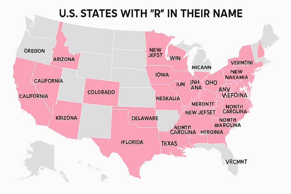
My goto is to ask LLMs how many states have R in their name. They always fail. GPT 5 included Indiana, Illinois, and Texas in its list. It then asked me if I wanted an alphabetical highlighted map. Sure, why not.
August 8, 2025 at 12:40 AM
My goto is to ask LLMs how many states have R in their name. They always fail. GPT 5 included Indiana, Illinois, and Texas in its list. It then asked me if I wanted an alphabetical highlighted map. Sure, why not.
Air quality over the U.S. right now is marginalized at best over CONUS. Here's a 'surface smoke' interactive map that updates hourly:
www.femafhz.com/map/40.94671...
www.femafhz.com/map/40.94671...

August 4, 2025 at 3:35 PM
Air quality over the U.S. right now is marginalized at best over CONUS. Here's a 'surface smoke' interactive map that updates hourly:
www.femafhz.com/map/40.94671...
www.femafhz.com/map/40.94671...
Reposted by Postholer - Hiking & GIS

Our #livestream runs 24/7. But when the microfiche scanning team takes a well-earned break, the feed keeps rolling, with #lofi music accompanying home movies, silent films & other gems from the Internet Archive.
Here's a sample.
Tune in ➡️ www.youtube.com/live/aPg2V5R...
Here's a sample.
Tune in ➡️ www.youtube.com/live/aPg2V5R...
August 2, 2025 at 1:02 PM
Our #livestream runs 24/7. But when the microfiche scanning team takes a well-earned break, the feed keeps rolling, with #lofi music accompanying home movies, silent films & other gems from the Internet Archive.
Here's a sample.
Tune in ➡️ www.youtube.com/live/aPg2V5R...
Here's a sample.
Tune in ➡️ www.youtube.com/live/aPg2V5R...
Since everyone is getting all worked up for no reason regarding a west-coast #tsunami, I'll post an image of Crescent City, CA tsunami evac zones. Being a CC resident, I'll predict this #earthquake will be a non-event. Click the 'evac zones' in the interactive map layers:
www.delnorteresort.com
www.delnorteresort.com

July 30, 2025 at 4:05 AM
Since everyone is getting all worked up for no reason regarding a west-coast #tsunami, I'll post an image of Crescent City, CA tsunami evac zones. Being a CC resident, I'll predict this #earthquake will be a non-event. Click the 'evac zones' in the interactive map layers:
www.delnorteresort.com
www.delnorteresort.com
Sleeping bag temperature rating: An interactive map
What 'season' bag do I need? This map shows 5 ranges: 1,2,3,4 season and extreme, for every month of the year. Here's the @pacificcresttrail.bsky.social for May:
www.postholer.com/map/Pacific-...
Available for anywhere in the lower 48 states.
What 'season' bag do I need? This map shows 5 ranges: 1,2,3,4 season and extreme, for every month of the year. Here's the @pacificcresttrail.bsky.social for May:
www.postholer.com/map/Pacific-...
Available for anywhere in the lower 48 states.

July 20, 2025 at 8:32 PM
Sleeping bag temperature rating: An interactive map
What 'season' bag do I need? This map shows 5 ranges: 1,2,3,4 season and extreme, for every month of the year. Here's the @pacificcresttrail.bsky.social for May:
www.postholer.com/map/Pacific-...
Available for anywhere in the lower 48 states.
What 'season' bag do I need? This map shows 5 ranges: 1,2,3,4 season and extreme, for every month of the year. Here's the @pacificcresttrail.bsky.social for May:
www.postholer.com/map/Pacific-...
Available for anywhere in the lower 48 states.
Camp Mystic building footprints and their placement in FEMA flood zones. Kerr County flood data was last revised on Aug 4, 2022. The vast majority of buildings are in a 'High, Insurance Required' zone, the highest level.
www.femafhz.com/map/30.00863...
www.femafhz.com/map/30.00863...

July 12, 2025 at 4:17 PM
Camp Mystic building footprints and their placement in FEMA flood zones. Kerr County flood data was last revised on Aug 4, 2022. The vast majority of buildings are in a 'High, Insurance Required' zone, the highest level.
www.femafhz.com/map/30.00863...
www.femafhz.com/map/30.00863...
Tropical storm Chantal @noaa.gov, and #FEMA National Risk Index Score, for hurricane, at state level (zoom in for county or tract).
www.femafhz.com/map/38.77121...
www.femafhz.com/map/38.77121...

July 5, 2025 at 4:57 PM
Tropical storm Chantal @noaa.gov, and #FEMA National Risk Index Score, for hurricane, at state level (zoom in for county or tract).
www.femafhz.com/map/38.77121...
www.femafhz.com/map/38.77121...