


Robin Wilson
@robintw.bsky.social
Freelance geospatial software engineer and data scientist. PhD in satellite imaging.
Blogger (https://blog.rtwilson.com/) author of the FreeGISData site (https://freegisdata.rtwilson.com/) & the British Placename Mapper (https://placenames.rtwilson.com/)
Blogger (https://blog.rtwilson.com/) author of the FreeGISData site (https://freegisdata.rtwilson.com/) & the British Placename Mapper (https://placenames.rtwilson.com/)
Reposted by Robin Wilson

2025 GDAL User Survey is now active for the entire month of December! Visit gdal.org/survey/ & tell the project how you use it, where you get help, what it should do in the future, & how/if it should use LLMs going forward. (optionally) give us your email, we'll even enter you to win a GDAL t-shirt!

2025 GDAL User Survey
In 2024, the GDAL User Survey solicited feedback to help focus GDAL Sponsorship Program activities. Your contribution mattered. Last years' results triggered the project to embark on the GDAL CLI Mode...
gdal.org
December 1, 2025 at 3:32 PM
2025 GDAL User Survey is now active for the entire month of December! Visit gdal.org/survey/ & tell the project how you use it, where you get help, what it should do in the future, & how/if it should use LLMs going forward. (optionally) give us your email, we'll even enter you to win a GDAL t-shirt!
Reposted by Robin Wilson

We have now uploaded all the recorded sessions from #FOSS4GUK 2025 in Leeds. 📹🦉
We would now invite everyone else to our youtube channel if you would like to catch up on the 35 recorded session.
www.youtube.com/watch?v=qCKv...
We would now invite everyone else to our youtube channel if you would like to catch up on the 35 recorded session.
www.youtube.com/watch?v=qCKv...

Welcome to FOSS4G:UK 2025
YouTube video by FOSS4G:UK
www.youtube.com
October 17, 2025 at 4:05 PM
We have now uploaded all the recorded sessions from #FOSS4GUK 2025 in Leeds. 📹🦉
We would now invite everyone else to our youtube channel if you would like to catch up on the 35 recorded session.
www.youtube.com/watch?v=qCKv...
We would now invite everyone else to our youtube channel if you would like to catch up on the 35 recorded session.
www.youtube.com/watch?v=qCKv...
Very proud of my former student (now colleague!), Gabi, who just gave her first conference presentation at #foss4guk in Leeds.
#geospatial #gis #osgeo #postgis
#geospatial #gis #osgeo #postgis

October 1, 2025 at 10:44 AM
Very proud of my former student (now colleague!), Gabi, who just gave her first conference presentation at #foss4guk in Leeds.
#geospatial #gis #osgeo #postgis
#geospatial #gis #osgeo #postgis
The new 'gdal raster neighbours' function is pretty cool - it does convolution across a raster, with configurable kernels and other options. Not yet released, but available in dev builds. See gdal.org/en/latest/pr... for details.
gdal raster neighbors — GDAL documentation
gdal.org
September 30, 2025 at 4:27 PM
The new 'gdal raster neighbours' function is pretty cool - it does convolution across a raster, with configurable kernels and other options. Not yet released, but available in dev builds. See gdal.org/en/latest/pr... for details.
Looking forward to #foss4guk this week in Leeds.
I'll be attending with a colleague, running a workshop on producing live vector tiles from PostGIS and my colleague will be giving a talk.
Now just to hope that the trains work better than last year: I got stuck in Bristol TM because the lift broke!
I'll be attending with a colleague, running a workshop on producing live vector tiles from PostGIS and my colleague will be giving a talk.
Now just to hope that the trains work better than last year: I got stuck in Bristol TM because the lift broke!
September 28, 2025 at 6:51 PM
Looking forward to #foss4guk this week in Leeds.
I'll be attending with a colleague, running a workshop on producing live vector tiles from PostGIS and my colleague will be giving a talk.
Now just to hope that the trains work better than last year: I got stuck in Bristol TM because the lift broke!
I'll be attending with a colleague, running a workshop on producing live vector tiles from PostGIS and my colleague will be giving a talk.
Now just to hope that the trains work better than last year: I got stuck in Bristol TM because the lift broke!
Debated about buying some heavy water today...for my #emfcamp talk/demo but a) it's very expensive and b) it'd probably get me put on a list. I'm consoling myself by buying high wattage halogen lamps instead.
September 27, 2025 at 10:11 PM
Debated about buying some heavy water today...for my #emfcamp talk/demo but a) it's very expensive and b) it'd probably get me put on a list. I'm consoling myself by buying high wattage halogen lamps instead.
Reposted by Robin Wilson

@pwramsey.bsky.social and I are hosting PostGIS Day again this year! The call for papers and registration is open now. Join us!
www.snowflake.com/postgis-day-...
www.snowflake.com/postgis-day-...

PostGIS Day | November 20
Learn how others are making use of PostGIS, pick up some tips and tricks, and share stories about bringing this excellent tool into your organizations.
www.snowflake.com
September 17, 2025 at 2:07 PM
@pwramsey.bsky.social and I are hosting PostGIS Day again this year! The call for papers and registration is open now. Join us!
www.snowflake.com/postgis-day-...
www.snowflake.com/postgis-day-...
Does anyone know any good books about the UK telephone network? Ideally I'd be interested in a history of the network, exchange development, memories of working on the network, big events (eg. phONEday etc) - but I can't seem to find anything like this
August 23, 2025 at 5:34 PM
Does anyone know any good books about the UK telephone network? Ideally I'd be interested in a history of the network, exchange development, memories of working on the network, big events (eg. phONEday etc) - but I can't seem to find anything like this
Reposted by Robin Wilson
Orbio Earth just open-sourced their full methane detection pipeline—models, tools, synthetic-plume engine & validation notebooks—for Sentinel-2, Landsat 8/9, and EMIT. #Methane #ClimateTech #OpenSource - orbio-earth.github.io/Project-Euca...

August 8, 2025 at 3:46 PM
Orbio Earth just open-sourced their full methane detection pipeline—models, tools, synthetic-plume engine & validation notebooks—for Sentinel-2, Landsat 8/9, and EMIT. #Methane #ClimateTech #OpenSource - orbio-earth.github.io/Project-Euca...
So, TIL that a MultiPolygon is invalid if any of its polygon parts touch at more than a single point. Eg. a MultiPolygon where two 'polygon parts' share an edge is invalid.
I can see why this is the case - those two polygon parts should be merged, but it's a bit annoying.
#gis
I can see why this is the case - those two polygon parts should be merged, but it's a bit annoying.
#gis

August 7, 2025 at 3:22 PM
So, TIL that a MultiPolygon is invalid if any of its polygon parts touch at more than a single point. Eg. a MultiPolygon where two 'polygon parts' share an edge is invalid.
I can see why this is the case - those two polygon parts should be merged, but it's a bit annoying.
#gis
I can see why this is the case - those two polygon parts should be merged, but it's a bit annoying.
#gis
I won't be able to make this as my wife is in the US at the time and so I'm needed at home - but I've had a great time at PyCon UK in the past, and I'm already looking forward to watching the videos of some of these talks.

📣📣 Announcement: full PyCon UK 2025 programme is now LIVE! 📣📣
It’s here, folks! The full schedule is up, and it’s chock-full of talks, workshops & more! 🎉🐍🌟
Schedule is over here 👉 buff.ly/9UtKEOl
Tickets this way 👉 buff.ly/83NpL2R
#Python #TechEvents #development #manchester #PythonProgramming
It’s here, folks! The full schedule is up, and it’s chock-full of talks, workshops & more! 🎉🐍🌟
Schedule is over here 👉 buff.ly/9UtKEOl
Tickets this way 👉 buff.ly/83NpL2R
#Python #TechEvents #development #manchester #PythonProgramming

Schedule – PyCon UK 2025
PyCon UK Friday 19th September to Monday 22nd September 2025, Contact Theatre, Manchester
2025.pyconuk.org
August 5, 2025 at 6:57 PM
I won't be able to make this as my wife is in the US at the time and so I'm needed at home - but I've had a great time at PyCon UK in the past, and I'm already looking forward to watching the videos of some of these talks.
Pleased to announce that I'll be giving a workshop at #foss4guk entitled 'Live Vector Tiles from PostGIS with pg_tileserv: A Hands-on Workshop' - I'll take you through the full process of using pg_tileserv to serve vector tiles to web maps (using MapLibre, Leaflet etc) and QGIS. Come along!
August 5, 2025 at 6:32 PM
Pleased to announce that I'll be giving a workshop at #foss4guk entitled 'Live Vector Tiles from PostGIS with pg_tileserv: A Hands-on Workshop' - I'll take you through the full process of using pg_tileserv to serve vector tiles to web maps (using MapLibre, Leaflet etc) and QGIS. Come along!
The Placing Technology blog (placing.technology) is utterly fascinating - someone blogging parts of their PhD research about the history of GIS and geospatial technologies in general.
Placing Technologies
The latest entries posted on Placing Technologies
placing.technology
August 4, 2025 at 8:56 PM
The Placing Technology blog (placing.technology) is utterly fascinating - someone blogging parts of their PhD research about the history of GIS and geospatial technologies in general.
The bubble mixture recipe for big bubbles on this blog is awesome - easy to make and works far better than others I've tried in the past!
juliawise.net/misc-parenti...
Thanks @juliawise.bsky.social
juliawise.net/misc-parenti...
Thanks @juliawise.bsky.social

Misc parenting ideas for summer • Otherwise
Assorted tips and activities I've used lately
juliawise.net
July 25, 2025 at 2:04 PM
The bubble mixture recipe for big bubbles on this blog is awesome - easy to make and works far better than others I've tried in the past!
juliawise.net/misc-parenti...
Thanks @juliawise.bsky.social
juliawise.net/misc-parenti...
Thanks @juliawise.bsky.social
Just reviewed the list of talks/workshops for #foss4g2025 in Auckland - there are loads of really cool submissions. Such a shame I won't be able to be there, but I'll look forward to the videos. You can review them too at 2025.foss4g.org/attend/call-...
Very simple to review, just 4 options!
Very simple to review, just 4 options!

FOSS4G Auckland 2025
FOSS4G stands for Free and Open Source Software for Geospatial, a conference hosted in partnership with OSGeo.
2025.foss4g.org
July 22, 2025 at 10:26 AM
Just reviewed the list of talks/workshops for #foss4g2025 in Auckland - there are loads of really cool submissions. Such a shame I won't be able to be there, but I'll look forward to the videos. You can review them too at 2025.foss4g.org/attend/call-...
Very simple to review, just 4 options!
Very simple to review, just 4 options!
Reposted by Robin Wilson

We are finally ready to announce that EMF 2026 will happen on July 16-19, 2026, at Eastnor Castle Deer Park, Herefordshire.
Expect more updates soon as we start spinning up the organisation again.
Expect more updates soon as we start spinning up the organisation again.
July 20, 2025 at 6:31 PM
We are finally ready to announce that EMF 2026 will happen on July 16-19, 2026, at Eastnor Castle Deer Park, Herefordshire.
Expect more updates soon as we start spinning up the organisation again.
Expect more updates soon as we start spinning up the organisation again.
Surprised to find out today that my talk on UK railway signalling at #emfcamp from a few years ago has now had over 3,500 views! It's at www.youtube.com/watch?v=cryU... if you'd like to watch it.

Robin Wilson: Learning from accidents: an introduction to railway signalling in the UK
YouTube video by Electromagnetic Field
www.youtube.com
July 14, 2025 at 1:09 PM
Surprised to find out today that my talk on UK railway signalling at #emfcamp from a few years ago has now had over 3,500 views! It's at www.youtube.com/watch?v=cryU... if you'd like to watch it.
Reposted by Robin Wilson

🚨 Alert. Alert.
The closing date for presentation submissions for #FOSS4GUK is rapidly approaching.
Submit your talks here: uk.osgeo.org/foss4guk2025...
It can be opinions, about projects, new ideas, breaking down technical concepts. Whatever topic you want, just involve open geospatial!
The closing date for presentation submissions for #FOSS4GUK is rapidly approaching.
Submit your talks here: uk.osgeo.org/foss4guk2025...
It can be opinions, about projects, new ideas, breaking down technical concepts. Whatever topic you want, just involve open geospatial!
FOSS4G:UK 2025 Leeds Call for Talks
OSGeo:UK
uk.osgeo.org
July 8, 2025 at 4:15 PM
🚨 Alert. Alert.
The closing date for presentation submissions for #FOSS4GUK is rapidly approaching.
Submit your talks here: uk.osgeo.org/foss4guk2025...
It can be opinions, about projects, new ideas, breaking down technical concepts. Whatever topic you want, just involve open geospatial!
The closing date for presentation submissions for #FOSS4GUK is rapidly approaching.
Submit your talks here: uk.osgeo.org/foss4guk2025...
It can be opinions, about projects, new ideas, breaking down technical concepts. Whatever topic you want, just involve open geospatial!
Found a cool feature of ogr2ogr: you can use SQL like 'SELECT * EXCEPT (col1, col2) FROM table' with the -sql parameter to exclude a few fields from the conversion process. Handy when you've got lots of fields and don't want to list them all out in the SELECT.
See gdal.org/en/stable/us...
#gis #gdal
See gdal.org/en/stable/us...
#gis #gdal
OGR SQL dialect — GDAL documentation
gdal.org
June 30, 2025 at 10:12 AM
Found a cool feature of ogr2ogr: you can use SQL like 'SELECT * EXCEPT (col1, col2) FROM table' with the -sql parameter to exclude a few fields from the conversion process. Handy when you've got lots of fields and don't want to list them all out in the SELECT.
See gdal.org/en/stable/us...
#gis #gdal
See gdal.org/en/stable/us...
#gis #gdal
Thinking of proposing a workshop at FOSS4G UK 2025 on on-the-fly tile generation for webmaps. Could cover MVT generation using PostGIS and pg_tileserv, raster tile generation using Titiler etc, or both?
Any preferences? Or particular things I should cover?
#foss4g #foss4guk #osgeo #gis
Any preferences? Or particular things I should cover?
#foss4g #foss4guk #osgeo #gis
June 21, 2025 at 4:14 PM
Just bought my ticket for @uk.osgeo.org's FOSS4G UK conference in October. Excited to attend on behalf of Rebalance Earth, and with some colleagues. Now just to write my workshop proposal...
#gis #foss4g
#gis #foss4g
June 18, 2025 at 12:56 PM
Just bought my ticket for @uk.osgeo.org's FOSS4G UK conference in October. Excited to attend on behalf of Rebalance Earth, and with some colleagues. Now just to write my workshop proposal...
#gis #foss4g
#gis #foss4g
New-ish post on my blog: it's another links post - that's all I seem to be able to get round to writing at the moment.
Anyway blog.rtwilson.com/more-links-j... has links on a range of topics including #python #geospatial #gis #stac #postgres and #3dprinting. Enjoy!
Anyway blog.rtwilson.com/more-links-j... has links on a range of topics including #python #geospatial #gis #stac #postgres and #3dprinting. Enjoy!
More links – June 2025 « Robin's Blog
blog.rtwilson.com
June 14, 2025 at 12:06 PM
New-ish post on my blog: it's another links post - that's all I seem to be able to get round to writing at the moment.
Anyway blog.rtwilson.com/more-links-j... has links on a range of topics including #python #geospatial #gis #stac #postgres and #3dprinting. Enjoy!
Anyway blog.rtwilson.com/more-links-j... has links on a range of topics including #python #geospatial #gis #stac #postgres and #3dprinting. Enjoy!
This new functionality for seasonal grouping in xarray is nice: xarray.dev/blog/season-... - In one of the talks I gave about xarray years ago (at @ajgwords.bsky.social's Rasters Revealed, I think) I was asked a question about the season grouping being N Hemisphere focused - now I have a solution!
Ergonomic seasonal grouping and resampling
Introducing new SeasonalGrouper and SeasonResampler objects
xarray.dev
June 13, 2025 at 8:19 AM
This new functionality for seasonal grouping in xarray is nice: xarray.dev/blog/season-... - In one of the talks I gave about xarray years ago (at @ajgwords.bsky.social's Rasters Revealed, I think) I was asked a question about the season grouping being N Hemisphere focused - now I have a solution!
Reposted by Robin Wilson
USGS, which operates the Landsat satellites, just announced that Landsat 7 was officially decommissioned today. Landsat 8 and 9 continue operations.
www.usgs.gov/news/nationa...
www.usgs.gov/news/nationa...
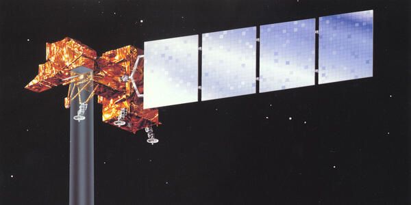
End of an Era: Landsat 7 Decommissioned After 25 Years of Earth Observation
After 25 years of capturing Earth's changing landscape, the Landsat 7 satellite received its final transmission from the U.S. Geological Survey and was officially decommissioned June 4, closing a rema...
www.usgs.gov
June 4, 2025 at 5:35 PM
USGS, which operates the Landsat satellites, just announced that Landsat 7 was officially decommissioned today. Landsat 8 and 9 continue operations.
www.usgs.gov/news/nationa...
www.usgs.gov/news/nationa...
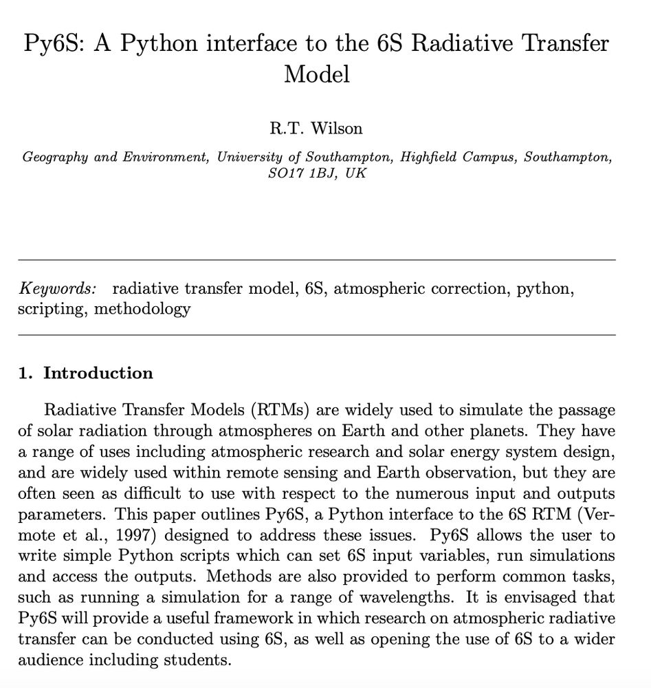
Quite chuffed that my paper on Py6S - a Python interface I developed to the 6S Atmospheric Radiative Transfer model has now got to 200 citations. Not bad for a "software paper that will never get cited" as some people told me at the time!
#python #science #remotesensing
#python #science #remotesensing
May 30, 2025 at 5:39 PM
Quite chuffed that my paper on Py6S - a Python interface I developed to the 6S Atmospheric Radiative Transfer model has now got to 200 citations. Not bad for a "software paper that will never get cited" as some people told me at the time!
#python #science #remotesensing
#python #science #remotesensing