


Eric Ness
@eric.ness.net
Dad, husband, programmer, popcorn enthusiast.
Computer Science PhD candidate @AngliaRuskin (Machine Learning, Remote Sensing, Env. Data). Day job: prog. tools to analyze environmental data. Website: https://eric.ness.net/ Posting stuff l am looking at.
Computer Science PhD candidate @AngliaRuskin (Machine Learning, Remote Sensing, Env. Data). Day job: prog. tools to analyze environmental data. Website: https://eric.ness.net/ Posting stuff l am looking at.
I built a GitHub issue–centric workflow framework for Claude Code. A GitHub issue # drives everything: plan → audit → execute → review. Fully configurable (TDD, ADR, etc.). At this point, my 9-year-old could probably do most of my job. github.com/Eric-Ness/Tiki

GitHub - Eric-Ness/Tiki
Contribute to Eric-Ness/Tiki development by creating an account on GitHub.
github.com
January 12, 2026 at 5:41 PM
I built a GitHub issue–centric workflow framework for Claude Code. A GitHub issue # drives everything: plan → audit → execute → review. Fully configurable (TDD, ADR, etc.). At this point, my 9-year-old could probably do most of my job. github.com/Eric-Ness/Tiki
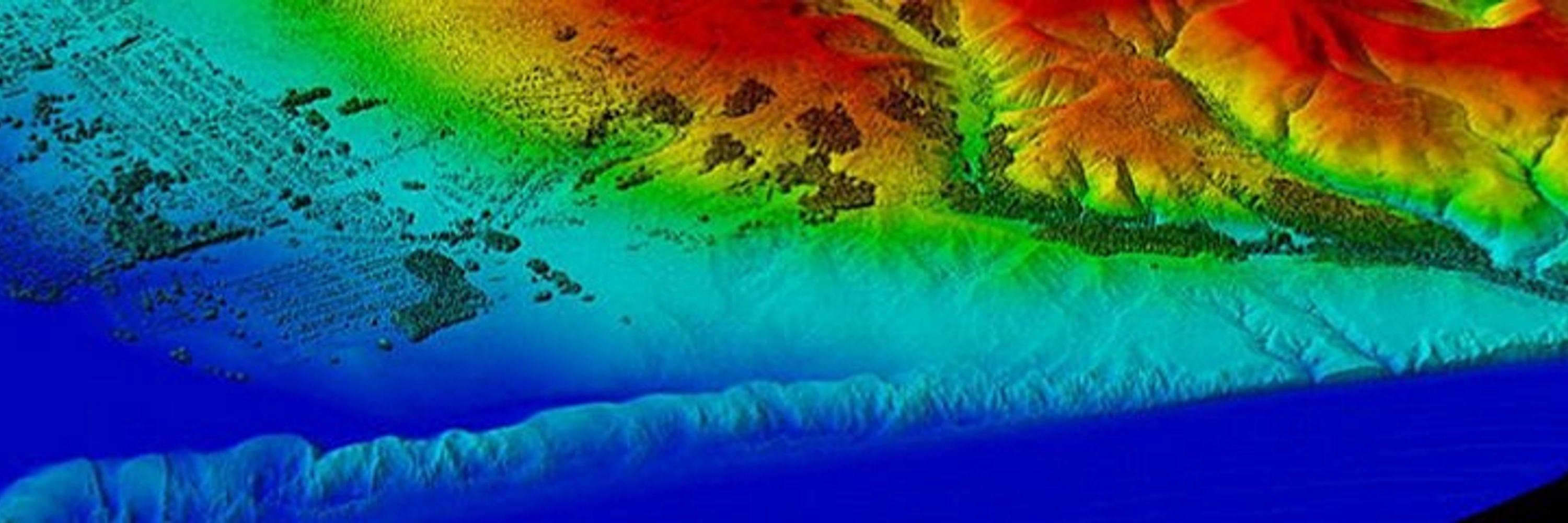
Big milestone today: I integrated my satellite-based water quality models into the web app I built. I can now view and interact with the models in one place. Shown here: chlorophyll-a in the Potomac and Anacostia Rivers.
#RemoteSensing #WaterQuality #GIS #Landsat #EarthObservation #DataScience
#RemoteSensing #WaterQuality #GIS #Landsat #EarthObservation #DataScience

January 2, 2026 at 7:53 PM
Big milestone today: I integrated my satellite-based water quality models into the web app I built. I can now view and interact with the models in one place. Shown here: chlorophyll-a in the Potomac and Anacostia Rivers.
#RemoteSensing #WaterQuality #GIS #Landsat #EarthObservation #DataScience
#RemoteSensing #WaterQuality #GIS #Landsat #EarthObservation #DataScience
Tired of firing up QGIS just to peek at a raster?
viewtif lets you:
• View single-band + RGB GeoTIFFs
• Overlay shapefiles
• Browse NetCDF time steps
• Open HDF/HDF5 + FileGDB rasters
All from the command line.
#GeoSpatial #Python - github.com/nkeikon/tifv...
viewtif lets you:
• View single-band + RGB GeoTIFFs
• Overlay shapefiles
• Browse NetCDF time steps
• Open HDF/HDF5 + FileGDB rasters
All from the command line.
#GeoSpatial #Python - github.com/nkeikon/tifv...
December 3, 2025 at 12:35 AM
Tired of firing up QGIS just to peek at a raster?
viewtif lets you:
• View single-band + RGB GeoTIFFs
• Overlay shapefiles
• Browse NetCDF time steps
• Open HDF/HDF5 + FileGDB rasters
All from the command line.
#GeoSpatial #Python - github.com/nkeikon/tifv...
viewtif lets you:
• View single-band + RGB GeoTIFFs
• Overlay shapefiles
• Browse NetCDF time steps
• Open HDF/HDF5 + FileGDB rasters
All from the command line.
#GeoSpatial #Python - github.com/nkeikon/tifv...
SWOT captured 65-ft waves during Storm Eddie, the tallest ever measured from orbit. These waves traveled 15,000 miles, carrying the storm’s power across entire oceans. #SWOT #EarthObservation #RemoteSensing #ClimateScience www.space.com/space-explor...

November 25, 2025 at 6:38 PM
SWOT captured 65-ft waves during Storm Eddie, the tallest ever measured from orbit. These waves traveled 15,000 miles, carrying the storm’s power across entire oceans. #SWOT #EarthObservation #RemoteSensing #ClimateScience www.space.com/space-explor...
The World Bank just released updated high-resolution official boundaries (Admin 0–2) across GeoJSON, Shapefile & GeoPackage. Includes NDLSA areas, ocean masks, and full data dictionary + attribute tables. #GIS #RemoteSensing #Geospatial datacatalog.worldbank.org/search/datas...
World Bank Official Boundaries | Data Catalog
High resolution, World Bank-approved administrative boundaries. Each download option (shapefile, GeoPackage, or GeoJSON format) includes Admin 0, 1, 2, Non-Determined Legal Status Areas (NDLSA), and a...
datacatalog.worldbank.org
November 24, 2025 at 8:59 PM
The World Bank just released updated high-resolution official boundaries (Admin 0–2) across GeoJSON, Shapefile & GeoPackage. Includes NDLSA areas, ocean masks, and full data dictionary + attribute tables. #GIS #RemoteSensing #Geospatial datacatalog.worldbank.org/search/datas...
Burnscar Detection Pipeline: NASA FIRMS + Sentinel-2 + Google Earth Engine + SQLMesh + DuckDB = open-source system to spot suspicious burn scars & potential arson events. #OSINT #RemoteSensing #FIRMS
Library: github.com/Centre-for-I...
Writeup: bigdatarepublic.nl/articles/det...
Library: github.com/Centre-for-I...
Writeup: bigdatarepublic.nl/articles/det...

November 21, 2025 at 7:44 PM
Burnscar Detection Pipeline: NASA FIRMS + Sentinel-2 + Google Earth Engine + SQLMesh + DuckDB = open-source system to spot suspicious burn scars & potential arson events. #OSINT #RemoteSensing #FIRMS
Library: github.com/Centre-for-I...
Writeup: bigdatarepublic.nl/articles/det...
Library: github.com/Centre-for-I...
Writeup: bigdatarepublic.nl/articles/det...
So I just implemented a major update to the news clustering algorithm on newsmap.org. If anyone is interested, I am also currently supporting a number of new languages.

November 21, 2025 at 4:10 PM
So I just implemented a major update to the news clustering algorithm on newsmap.org. If anyone is interested, I am also currently supporting a number of new languages.
Wildfire modeling just got faster. PROPAGATOR uses stochastic cellular automata + rate-of-spread physics to simulate fire behavior in minutes — helping emergency teams make real-time decisions. #GIS #EmergencyManagement #RemoteSensing www.mdpi.com/2571-6255/3/...

November 20, 2025 at 5:37 PM
Wildfire modeling just got faster. PROPAGATOR uses stochastic cellular automata + rate-of-spread physics to simulate fire behavior in minutes — helping emergency teams make real-time decisions. #GIS #EmergencyManagement #RemoteSensing www.mdpi.com/2571-6255/3/...
My cat's litter box is connected to the Internet. Surely this is a sign of the end of days.
November 20, 2025 at 1:20 AM
My cat's litter box is connected to the Internet. Surely this is a sign of the end of days.
This looks interesting — Lonboard 0.13 just dropped and now supports H3, S2, Geohash, and even A5 layers. Lots of new ways to explore geospatial grids in Python.
#GIS #GeoPython #Lonboard - github.com/developments...
#GIS #GeoPython #Lonboard - github.com/developments...

GitHub - developmentseed/lonboard: A Python library for fast, interactive geospatial vector data visualization in Jupyter.
A Python library for fast, interactive geospatial vector data visualization in Jupyter. - developmentseed/lonboard
github.com
November 19, 2025 at 8:13 PM
This looks interesting — Lonboard 0.13 just dropped and now supports H3, S2, Geohash, and even A5 layers. Lots of new ways to explore geospatial grids in Python.
#GIS #GeoPython #Lonboard - github.com/developments...
#GIS #GeoPython #Lonboard - github.com/developments...
SAR satellites don’t need daylight — they image Earth day, night, rain, or clouds. Different radar bands (P, L, S, C, X, Ku, K, Ka) reveal everything from subsurface rivers to cars in a parking lot. Wild tech. #SAR #RemoteSensing #EarthObservation #Radar #Geospatial - www.youtube.com/watch?v=TT6c...

Why does Synthetic Aperture Radar use different wavelengths? | SAR bands explained
YouTube video by sigma nought
www.youtube.com
November 18, 2025 at 10:06 PM
SAR satellites don’t need daylight — they image Earth day, night, rain, or clouds. Different radar bands (P, L, S, C, X, Ku, K, Ka) reveal everything from subsurface rivers to cars in a parking lot. Wild tech. #SAR #RemoteSensing #EarthObservation #Radar #Geospatial - www.youtube.com/watch?v=TT6c...
Reposted by Eric Ness

Analysis finds China's CO2 emissions have been flat or falling for 18 months due to increased solar & wind power. Sector emissions remained flat despite rising electricity demand. #ClimateChange #News

China’s CO2 emissions have been flat or falling for past 18 months, analysis finds
Analysis finds China's CO2 emissions have been flat or falling for 18 months due to increased solar ...
www.theguardian.com
November 11, 2025 at 11:30 AM
Analysis finds China's CO2 emissions have been flat or falling for 18 months due to increased solar & wind power. Sector emissions remained flat despite rising electricity demand. #ClimateChange #News
Tired of hunting down shapefiles? The new wkls Python library gives you instant access to 625K global administrative boundaries with clean, chainable syntax — no downloading, no parsing. Just wkls.us.nyc.cityofnewyork.wkt()
#GIS #Python #GeoSpatial #Wherobots - github.com/wherobots/wk...
#GIS #Python #GeoSpatial #Wherobots - github.com/wherobots/wk...

November 18, 2025 at 6:48 PM
Tired of hunting down shapefiles? The new wkls Python library gives you instant access to 625K global administrative boundaries with clean, chainable syntax — no downloading, no parsing. Just wkls.us.nyc.cityofnewyork.wkt()
#GIS #Python #GeoSpatial #Wherobots - github.com/wherobots/wk...
#GIS #Python #GeoSpatial #Wherobots - github.com/wherobots/wk...
With a $600 satellite dish and open-source software, UCSD & UMD researchers intercepted cleartext IP traffic from 50% of GEO satellite links — voice calls, grid data, in-flight WiFi, retail systems, even military assets. - satcom.sysnet.ucsd.edu/docs/dontloo...

October 23, 2025 at 11:45 PM
With a $600 satellite dish and open-source software, UCSD & UMD researchers intercepted cleartext IP traffic from 50% of GEO satellite links — voice calls, grid data, in-flight WiFi, retail systems, even military assets. - satcom.sysnet.ucsd.edu/docs/dontloo...
If you’ve ever wondered where endless scam calls come from… SIM farms. USSS just shut a few down. That’s good news. But no, they weren’t going to knock out every phone in New York. - www.youtube.com/watch?v=TBZj...

Did The Secret Service Really Foil A Plot To Destroy New York's Cellphone Infrastructure?
YouTube video by Marcus Hutchins
www.youtube.com
September 25, 2025 at 7:10 PM
If you’ve ever wondered where endless scam calls come from… SIM farms. USSS just shut a few down. That’s good news. But no, they weren’t going to knock out every phone in New York. - www.youtube.com/watch?v=TBZj...
Orbio Earth just open-sourced their full methane detection pipeline—models, tools, synthetic-plume engine & validation notebooks—for Sentinel-2, Landsat 8/9, and EMIT. #Methane #ClimateTech #OpenSource - orbio-earth.github.io/Project-Euca...

August 8, 2025 at 3:46 PM
Orbio Earth just open-sourced their full methane detection pipeline—models, tools, synthetic-plume engine & validation notebooks—for Sentinel-2, Landsat 8/9, and EMIT. #Methane #ClimateTech #OpenSource - orbio-earth.github.io/Project-Euca...
How do we track water flowing through rivers from space? This major review says: 1–3 day revisit. Resolution down to 30–100 m widths. Must include width, slope, & velocity. Flood forecasting + water management depend on it. #EarthObservation #RemoteSensing #WaterResources doi.org/10.1029/2024...

August 7, 2025 at 1:18 PM
How do we track water flowing through rivers from space? This major review says: 1–3 day revisit. Resolution down to 30–100 m widths. Must include width, slope, & velocity. Flood forecasting + water management depend on it. #EarthObservation #RemoteSensing #WaterResources doi.org/10.1029/2024...
The Trump administration is pushing NASA to kill two critical climate satellites. The Orbiting Carbon Observatories track CO₂ globally — data vital to scientists, farmers, and even oil companies. Cost? Just $15M/year. #ClimateScience #EarthObservation futurism.com/white-house-...
White House Orders NASA to Destroy Important Satellite
The White House has instructed NASA employees to destroy two major, climate change-focused satellite missions.
futurism.com
August 6, 2025 at 12:43 PM
The Trump administration is pushing NASA to kill two critical climate satellites. The Orbiting Carbon Observatories track CO₂ globally — data vital to scientists, farmers, and even oil companies. Cost? Just $15M/year. #ClimateScience #EarthObservation futurism.com/white-house-...
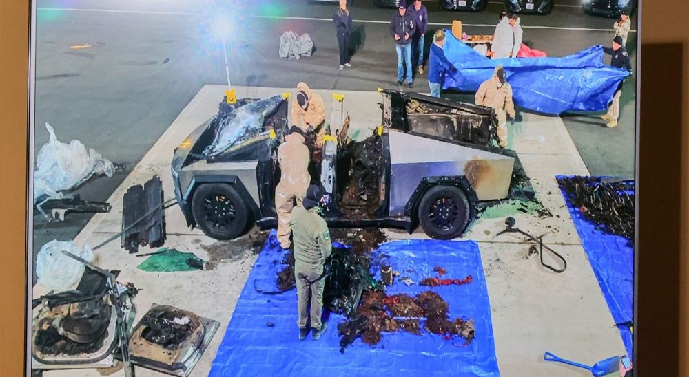
"At the current rate of horrible fiery deaths, FuelArc projects the Cybertruck will have 14.52 fatalities per 100,000 units — far eclipsing the Pinto's 0.85. " - futurism.com/the-byte/cyb...
The Cybertruck Appears to Be More Deadly Than the Infamous Ford Pinto, According to a New Analysis
A new analysis suggests that the Cybertruck might lead to 17 times more fatalities than the infamous Ford Pinto.
futurism.com
August 4, 2025 at 6:27 PM
"At the current rate of horrible fiery deaths, FuelArc projects the Cybertruck will have 14.52 fatalities per 100,000 units — far eclipsing the Pinto's 0.85. " - futurism.com/the-byte/cyb...
Want to overlay a heatmap on a real map using Python? This guide walks through visualizing EF3–EF5 tornado trends across the U.S. with NOAA data, grid-based bins, and Matplotlib. Bonus: how to include tornado endpoints too!
#geospatial #Python towardsdatascience.com/how-to-overl...
#geospatial #Python towardsdatascience.com/how-to-overl...
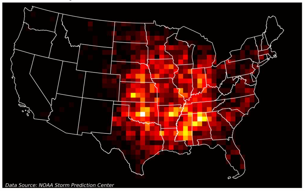
How to Overlay a Heatmap on a Real Map with Python | Towards Data Science
Visualizing historical tornado trends
towardsdatascience.com
July 17, 2025 at 5:55 PM
Want to overlay a heatmap on a real map using Python? This guide walks through visualizing EF3–EF5 tornado trends across the U.S. with NOAA data, grid-based bins, and Matplotlib. Bonus: how to include tornado endpoints too!
#geospatial #Python towardsdatascience.com/how-to-overl...
#geospatial #Python towardsdatascience.com/how-to-overl...
Just launched: SMAP salinity data V5.0 + V5.3 with ice/ocean flags — available now via NASA’s SNWG Earthdata Portal. Track salinity near the sea ice edge like never before. #SeaSurfaceSalinity #NASAData www.earthdata.nasa.gov/news/sea-sur...

Sea Surface Salinity Datasets Now Available on the SNWG Earthdata Search Portal | NASA Earthdata
Access Sea Surface Salinity with Sea Ice Mask, a NASA Satellite Needs Working Group solution, to discern salinity values close to the sea ice edge.
www.earthdata.nasa.gov
July 10, 2025 at 2:08 PM
Just launched: SMAP salinity data V5.0 + V5.3 with ice/ocean flags — available now via NASA’s SNWG Earthdata Portal. Track salinity near the sea ice edge like never before. #SeaSurfaceSalinity #NASAData www.earthdata.nasa.gov/news/sea-sur...
A record-breaking heatwave is sweeping across southern Europe and North Africa. Copernicus Sentinel-3 reveals land surface temps far above normal – and the Mediterranean Sea isn't spared either. #ClimateCrisis #EarthObservation www.esa.int/ESA_Multimed...

Southern Europe’s land and sea sizzles
A powerful heatwave has been gripping large parts of southern Europe. This image, captured by the Copernicus Sentinel-3 mission’s Sea and Land Surface Temperature Radiometer on 29 June 2025, reveals t...
www.esa.int
July 8, 2025 at 8:40 PM
A record-breaking heatwave is sweeping across southern Europe and North Africa. Copernicus Sentinel-3 reveals land surface temps far above normal – and the Mediterranean Sea isn't spared either. #ClimateCrisis #EarthObservation www.esa.int/ESA_Multimed...
NASA’s PACE satellite just dropped a year of stunning hyperspectral data—mapping chlorophyll, carotenoids & anthocyanins globally, every 1–2 days. It's the first time we’re seeing land plants in full spectral color from space. #RemoteSensing #EarthObservation - svs.gsfc.nasa.gov/5548/
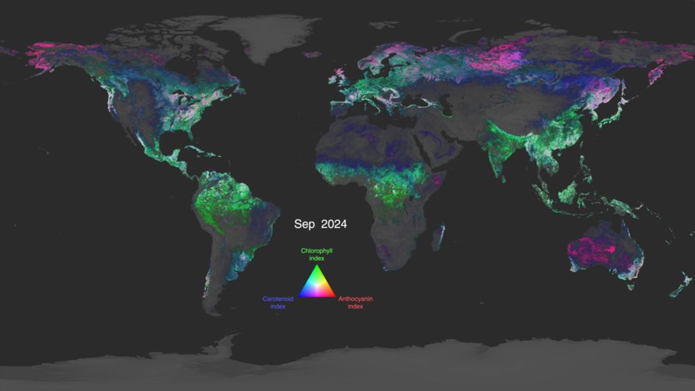
NASA Scientific Visualization Studio | Global Views of PACE Land Vegetation Data
Global view of three major classes of plant pigments observed by the PACE satellite: chlorophylls, carotenoids, and anthocyanins.
svs.gsfc.nasa.gov
July 3, 2025 at 3:04 PM
NASA’s PACE satellite just dropped a year of stunning hyperspectral data—mapping chlorophyll, carotenoids & anthocyanins globally, every 1–2 days. It's the first time we’re seeing land plants in full spectral color from space. #RemoteSensing #EarthObservation - svs.gsfc.nasa.gov/5548/
It appears that MethaneSAT is gone. Launched in March 2024 to track powerful methane leaks, the Bezos-backed satellite veered off course over Norway and lost power. #MethaneLeaks #ClimateChange #MethaneSAT www.reuters.com/business/ene...

Exclusive: Bezos-backed methane tracking satellite is lost in space
An $88 million satellite backed by billionaire Jeff Bezos that detected oil and gas industry's emissions of the powerful greenhouse gas methane has been lost in space, the group that operates it told Reuters on Tuesday.
www.reuters.com
July 2, 2025 at 4:07 PM
It appears that MethaneSAT is gone. Launched in March 2024 to track powerful methane leaks, the Bezos-backed satellite veered off course over Norway and lost power. #MethaneLeaks #ClimateChange #MethaneSAT www.reuters.com/business/ene...