


Eric Ness
@eric.ness.net
Dad, husband, programmer, popcorn enthusiast.
Computer Science PhD candidate @AngliaRuskin (Machine Learning, Remote Sensing, Env. Data). Day job: prog. tools to analyze environmental data. Website: https://eric.ness.net/ Posting stuff l am looking at.
Computer Science PhD candidate @AngliaRuskin (Machine Learning, Remote Sensing, Env. Data). Day job: prog. tools to analyze environmental data. Website: https://eric.ness.net/ Posting stuff l am looking at.
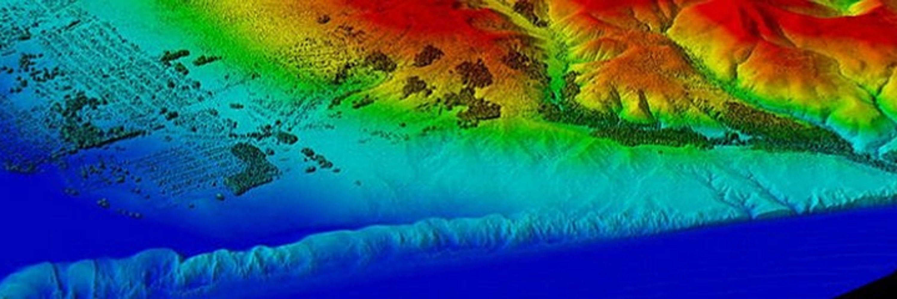
Big milestone today: I integrated my satellite-based water quality models into the web app I built. I can now view and interact with the models in one place. Shown here: chlorophyll-a in the Potomac and Anacostia Rivers.
#RemoteSensing #WaterQuality #GIS #Landsat #EarthObservation #DataScience
#RemoteSensing #WaterQuality #GIS #Landsat #EarthObservation #DataScience

January 2, 2026 at 7:53 PM
Big milestone today: I integrated my satellite-based water quality models into the web app I built. I can now view and interact with the models in one place. Shown here: chlorophyll-a in the Potomac and Anacostia Rivers.
#RemoteSensing #WaterQuality #GIS #Landsat #EarthObservation #DataScience
#RemoteSensing #WaterQuality #GIS #Landsat #EarthObservation #DataScience
Tired of firing up QGIS just to peek at a raster?
viewtif lets you:
• View single-band + RGB GeoTIFFs
• Overlay shapefiles
• Browse NetCDF time steps
• Open HDF/HDF5 + FileGDB rasters
All from the command line.
#GeoSpatial #Python - github.com/nkeikon/tifv...
viewtif lets you:
• View single-band + RGB GeoTIFFs
• Overlay shapefiles
• Browse NetCDF time steps
• Open HDF/HDF5 + FileGDB rasters
All from the command line.
#GeoSpatial #Python - github.com/nkeikon/tifv...
December 3, 2025 at 12:35 AM
Tired of firing up QGIS just to peek at a raster?
viewtif lets you:
• View single-band + RGB GeoTIFFs
• Overlay shapefiles
• Browse NetCDF time steps
• Open HDF/HDF5 + FileGDB rasters
All from the command line.
#GeoSpatial #Python - github.com/nkeikon/tifv...
viewtif lets you:
• View single-band + RGB GeoTIFFs
• Overlay shapefiles
• Browse NetCDF time steps
• Open HDF/HDF5 + FileGDB rasters
All from the command line.
#GeoSpatial #Python - github.com/nkeikon/tifv...
SWOT captured 65-ft waves during Storm Eddie, the tallest ever measured from orbit. These waves traveled 15,000 miles, carrying the storm’s power across entire oceans. #SWOT #EarthObservation #RemoteSensing #ClimateScience www.space.com/space-explor...

November 25, 2025 at 6:38 PM
SWOT captured 65-ft waves during Storm Eddie, the tallest ever measured from orbit. These waves traveled 15,000 miles, carrying the storm’s power across entire oceans. #SWOT #EarthObservation #RemoteSensing #ClimateScience www.space.com/space-explor...
Burnscar Detection Pipeline: NASA FIRMS + Sentinel-2 + Google Earth Engine + SQLMesh + DuckDB = open-source system to spot suspicious burn scars & potential arson events. #OSINT #RemoteSensing #FIRMS
Library: github.com/Centre-for-I...
Writeup: bigdatarepublic.nl/articles/det...
Library: github.com/Centre-for-I...
Writeup: bigdatarepublic.nl/articles/det...

November 21, 2025 at 7:44 PM
Burnscar Detection Pipeline: NASA FIRMS + Sentinel-2 + Google Earth Engine + SQLMesh + DuckDB = open-source system to spot suspicious burn scars & potential arson events. #OSINT #RemoteSensing #FIRMS
Library: github.com/Centre-for-I...
Writeup: bigdatarepublic.nl/articles/det...
Library: github.com/Centre-for-I...
Writeup: bigdatarepublic.nl/articles/det...
So I just implemented a major update to the news clustering algorithm on newsmap.org. If anyone is interested, I am also currently supporting a number of new languages.

November 21, 2025 at 4:10 PM
So I just implemented a major update to the news clustering algorithm on newsmap.org. If anyone is interested, I am also currently supporting a number of new languages.
Wildfire modeling just got faster. PROPAGATOR uses stochastic cellular automata + rate-of-spread physics to simulate fire behavior in minutes — helping emergency teams make real-time decisions. #GIS #EmergencyManagement #RemoteSensing www.mdpi.com/2571-6255/3/...

November 20, 2025 at 5:37 PM
Wildfire modeling just got faster. PROPAGATOR uses stochastic cellular automata + rate-of-spread physics to simulate fire behavior in minutes — helping emergency teams make real-time decisions. #GIS #EmergencyManagement #RemoteSensing www.mdpi.com/2571-6255/3/...
Tired of hunting down shapefiles? The new wkls Python library gives you instant access to 625K global administrative boundaries with clean, chainable syntax — no downloading, no parsing. Just wkls.us.nyc.cityofnewyork.wkt()
#GIS #Python #GeoSpatial #Wherobots - github.com/wherobots/wk...
#GIS #Python #GeoSpatial #Wherobots - github.com/wherobots/wk...

November 18, 2025 at 6:48 PM
Tired of hunting down shapefiles? The new wkls Python library gives you instant access to 625K global administrative boundaries with clean, chainable syntax — no downloading, no parsing. Just wkls.us.nyc.cityofnewyork.wkt()
#GIS #Python #GeoSpatial #Wherobots - github.com/wherobots/wk...
#GIS #Python #GeoSpatial #Wherobots - github.com/wherobots/wk...
With a $600 satellite dish and open-source software, UCSD & UMD researchers intercepted cleartext IP traffic from 50% of GEO satellite links — voice calls, grid data, in-flight WiFi, retail systems, even military assets. - satcom.sysnet.ucsd.edu/docs/dontloo...

October 23, 2025 at 11:45 PM
With a $600 satellite dish and open-source software, UCSD & UMD researchers intercepted cleartext IP traffic from 50% of GEO satellite links — voice calls, grid data, in-flight WiFi, retail systems, even military assets. - satcom.sysnet.ucsd.edu/docs/dontloo...
Orbio Earth just open-sourced their full methane detection pipeline—models, tools, synthetic-plume engine & validation notebooks—for Sentinel-2, Landsat 8/9, and EMIT. #Methane #ClimateTech #OpenSource - orbio-earth.github.io/Project-Euca...

August 8, 2025 at 3:46 PM
Orbio Earth just open-sourced their full methane detection pipeline—models, tools, synthetic-plume engine & validation notebooks—for Sentinel-2, Landsat 8/9, and EMIT. #Methane #ClimateTech #OpenSource - orbio-earth.github.io/Project-Euca...
How do we track water flowing through rivers from space? This major review says: 1–3 day revisit. Resolution down to 30–100 m widths. Must include width, slope, & velocity. Flood forecasting + water management depend on it. #EarthObservation #RemoteSensing #WaterResources doi.org/10.1029/2024...

August 7, 2025 at 1:18 PM
How do we track water flowing through rivers from space? This major review says: 1–3 day revisit. Resolution down to 30–100 m widths. Must include width, slope, & velocity. Flood forecasting + water management depend on it. #EarthObservation #RemoteSensing #WaterResources doi.org/10.1029/2024...
ChatGPT just released Codex. You can connect to a GitHub repository, and it will explain the codebase to newcomers, suggest codebase improvements, and identify and fix critical bugs. Then do a pull/merge request! Kind of awesome. chatgpt.com/codex/ #vibecoding #chatgpt #codex

June 6, 2025 at 1:33 PM
ChatGPT just released Codex. You can connect to a GitHub repository, and it will explain the codebase to newcomers, suggest codebase improvements, and identify and fix critical bugs. Then do a pull/merge request! Kind of awesome. chatgpt.com/codex/ #vibecoding #chatgpt #codex
Check out creative ways to export your maps from QGIS to Illustrator — then bring them to life with animations in Premiere!
#QGIS #Illustrator #PremierePro #MapDesign - www.chiaraphillips.com/post/make-th...
#QGIS #Illustrator #PremierePro #MapDesign - www.chiaraphillips.com/post/make-th...
May 11, 2025 at 12:15 PM
Check out creative ways to export your maps from QGIS to Illustrator — then bring them to life with animations in Premiere!
#QGIS #Illustrator #PremierePro #MapDesign - www.chiaraphillips.com/post/make-th...
#QGIS #Illustrator #PremierePro #MapDesign - www.chiaraphillips.com/post/make-th...
Over 90 technician vacancies threaten Doppler radar & surface station upkeep, risking prolonged outages when storms hit. Since Trump’s second term began, @noaa.gov has lost 550+ employees—the same number lost in the previous 15 years combined. #Meteorology - edition.cnn.com/2025/05/02/w...

May 9, 2025 at 1:32 PM
Over 90 technician vacancies threaten Doppler radar & surface station upkeep, risking prolonged outages when storms hit. Since Trump’s second term began, @noaa.gov has lost 550+ employees—the same number lost in the previous 15 years combined. #Meteorology - edition.cnn.com/2025/05/02/w...
So I have been busy working on this as of late. It's been a lot of fun.

May 8, 2025 at 2:00 PM
So I have been busy working on this as of late. It's been a lot of fun.
I like Mark Litwintschik's write-up/review of 'GeoDeep's AI Detection on Maxar's Satellite Imagery'. GeoDeep is a Python package that can detect objects in satellite imagery. In the walk, he detects cars, trees, buildings, roads, and planes. #AI #EO #remotesensing tech.marksblogg.com/geodeep-maxa...

May 1, 2025 at 2:41 PM
I like Mark Litwintschik's write-up/review of 'GeoDeep's AI Detection on Maxar's Satellite Imagery'. GeoDeep is a Python package that can detect objects in satellite imagery. In the walk, he detects cars, trees, buildings, roads, and planes. #AI #EO #remotesensing tech.marksblogg.com/geodeep-maxa...
A stark east-west split in 2024: Spain through northern Fennoscandia recorded record-wet conditions, while eastern Ukraine and parts of southwestern Russia endured their driest year since 1979. #WeatherExtremes climate.copernicus.eu/esotc/2024/p...

May 1, 2025 at 2:30 PM
A stark east-west split in 2024: Spain through northern Fennoscandia recorded record-wet conditions, while eastern Ukraine and parts of southwestern Russia endured their driest year since 1979. #WeatherExtremes climate.copernicus.eu/esotc/2024/p...
This is one of the better write-ups on @esaearth.esa.int #EarthCARE satellite data, which captures clouds, aerosols, and radiation. Early results show better forecasts and insights into storm dynamics, snowfall speeds, and global cloud behavior. #ESA #EO www.ecmwf.int/en/newslette...

April 30, 2025 at 11:47 PM
This is one of the better write-ups on @esaearth.esa.int #EarthCARE satellite data, which captures clouds, aerosols, and radiation. Early results show better forecasts and insights into storm dynamics, snowfall speeds, and global cloud behavior. #ESA #EO www.ecmwf.int/en/newslette...
This looks like a cool and quick tutorial on training a model for detecting solar panels using aerial imagery and GeoAI. Video: www.youtube.com/watch?v=_Omk... Code: geoai.gishub.org/examples/tra...

April 21, 2025 at 5:10 PM
This looks like a cool and quick tutorial on training a model for detecting solar panels using aerial imagery and GeoAI. Video: www.youtube.com/watch?v=_Omk... Code: geoai.gishub.org/examples/tra...
Introducing the Earth Observation Training Data Lab (EOTDL) by ESA! Learn how to create your own EO training datasets with EOTDL tutorials. Dive into STAC metadata, dataset ingestion, and model building. #RemoteSensing #OpenData #EO #MachineLearning www.eotdl.com
April 10, 2025 at 4:04 PM
Introducing the Earth Observation Training Data Lab (EOTDL) by ESA! Learn how to create your own EO training datasets with EOTDL tutorials. Dive into STAC metadata, dataset ingestion, and model building. #RemoteSensing #OpenData #EO #MachineLearning www.eotdl.com
2025 Antarctic sea ice stats are in:
• 7th lowest extent on record
• Volume down 56% from the long-term average
• 2nd year in a row below 2M km²
The melt is not uniform, but the trend is clear. #ClimateChange #Antarctica - marine.copernicus.eu/news/antarct...
• 7th lowest extent on record
• Volume down 56% from the long-term average
• 2nd year in a row below 2M km²
The melt is not uniform, but the trend is clear. #ClimateChange #Antarctica - marine.copernicus.eu/news/antarct...
April 1, 2025 at 2:14 PM
2025 Antarctic sea ice stats are in:
• 7th lowest extent on record
• Volume down 56% from the long-term average
• 2nd year in a row below 2M km²
The melt is not uniform, but the trend is clear. #ClimateChange #Antarctica - marine.copernicus.eu/news/antarct...
• 7th lowest extent on record
• Volume down 56% from the long-term average
• 2nd year in a row below 2M km²
The melt is not uniform, but the trend is clear. #ClimateChange #Antarctica - marine.copernicus.eu/news/antarct...
The Hitchcock/Truffaut audio tapes/interviews on YouTube. www.youtube.com/watch?v=Jq51...

March 27, 2025 at 6:40 PM
The Hitchcock/Truffaut audio tapes/interviews on YouTube. www.youtube.com/watch?v=Jq51...
Say hello to better climate models. EarthCARE’s new Level-2 products fuse radar, lidar, and imaging to reveal the atmosphere in 3D. Full data portfolio landing by Dec 2025. #EarthCARE #RemoteSensing #EarthObservation #ESA earth.esa.int/eogateway/ne...

March 27, 2025 at 5:39 PM
Say hello to better climate models. EarthCARE’s new Level-2 products fuse radar, lidar, and imaging to reveal the atmosphere in 3D. Full data portfolio landing by Dec 2025. #EarthCARE #RemoteSensing #EarthObservation #ESA earth.esa.int/eogateway/ne...
A great set of GIS font icons. github.com/Viglino/font...

March 24, 2025 at 2:23 PM
A great set of GIS font icons. github.com/Viglino/font...
By combining Ray-Ban Meta smart glasses I-XRAY proves a terrifying point: AI glasses today can expose your personal details—name, address, relatives—instantly. Opt-out guides for reverse face search and data brokers included. #privacy docs.google.com/document/d/1... github.com/yaelwrites/B...

March 18, 2025 at 8:38 PM
By combining Ray-Ban Meta smart glasses I-XRAY proves a terrifying point: AI glasses today can expose your personal details—name, address, relatives—instantly. Opt-out guides for reverse face search and data brokers included. #privacy docs.google.com/document/d/1... github.com/yaelwrites/B...
Sea levels rose faster than expected in 2024 — 0.23 inches vs. the projected 0.17 inches. Why? Record-breaking heat led to more ocean warming (thermal expansion) than ice melt. NASA: “The rate of rise is getting faster and faster.” - www.nasa.gov/missions/jas...

March 17, 2025 at 3:49 PM
Sea levels rose faster than expected in 2024 — 0.23 inches vs. the projected 0.17 inches. Why? Record-breaking heat led to more ocean warming (thermal expansion) than ice melt. NASA: “The rate of rise is getting faster and faster.” - www.nasa.gov/missions/jas...