


Tomasz Nycz
@sq9nit.bsky.social
Train manager at Koleje Śląskie
open-source GIS specialist and evangelist, cartographer
SQ9NIT
open-source GIS specialist and evangelist, cartographer
SQ9NIT
"Cztery sztandary, jeden adres" Ludwiki Włodek to najlepsza metafora na losy mojego zawodu. Kierownik pociągu życzy przyjemnej podróży i dobrego dnia 😀

March 19, 2025 at 7:00 AM
"Cztery sztandary, jeden adres" Ludwiki Włodek to najlepsza metafora na losy mojego zawodu. Kierownik pociągu życzy przyjemnej podróży i dobrego dnia 😀
Spokojnej podróży i dobrego dnia!

January 14, 2025 at 6:09 AM
Spokojnej podróży i dobrego dnia!
Zamek Ścibora ze Ściborzyc.W Beckovie, nad Wagiem. Spory.


December 28, 2024 at 2:55 PM
Zamek Ścibora ze Ściborzyc.W Beckovie, nad Wagiem. Spory.
W Istebnej gmina większa 🤪


December 28, 2024 at 12:20 PM
W Istebnej gmina większa 🤪
Godzina 4.50. Chcesz porozmawiać o pracy w niedziele i święta? Myślę, że wiem coś o tym. A teraz Dobranoc i Wesołych Świąt Narodzenia Pańskiego.

December 26, 2024 at 4:47 AM
Godzina 4.50. Chcesz porozmawiać o pracy w niedziele i święta? Myślę, że wiem coś o tym. A teraz Dobranoc i Wesołych Świąt Narodzenia Pańskiego.
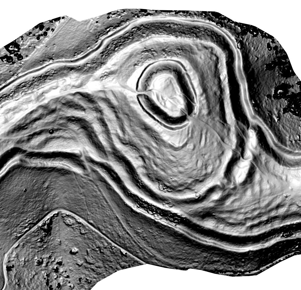
Mały Szaniec (Little Fort) - Jablunkov pass fortification system, XVI c. This fort was located at Wien-Cracow route on Silesia-Hungary border.
#HillfortsWednesday
#HillfortsWednesday

November 27, 2024 at 2:54 PM
Mały Szaniec (Little Fort) - Jablunkov pass fortification system, XVI c. This fort was located at Wien-Cracow route on Silesia-Hungary border.
#HillfortsWednesday
#HillfortsWednesday
Niech każdego dnia Św. Katarzyna Aleksandryjska prowadzi was przez życie, jak po stalowych szynach. Kolejarzom i tym za biurkiem i tym za nastawnikiem, jak i tym którzy trzymają w ręce gwizdek i chorągiewkę życzenia powodzenia w życiu zawodowym i prywatnym. I nie łamcie się!

November 25, 2024 at 5:55 AM
Niech każdego dnia Św. Katarzyna Aleksandryjska prowadzi was przez życie, jak po stalowych szynach. Kolejarzom i tym za biurkiem i tym za nastawnikiem, jak i tym którzy trzymają w ręce gwizdek i chorągiewkę życzenia powodzenia w życiu zawodowym i prywatnym. I nie łamcie się!
Reposted by Tomasz Nycz

Some of the posts we found in Spycimierz were about 5 metres long, 4 metres driven into the ground. You cannot do that with a hammer. You need a pile driver. You need specialised engineers. The construction of an early medieval wooden fortress wasn't the work of unskilled peasants.


November 21, 2024 at 1:39 PM
Some of the posts we found in Spycimierz were about 5 metres long, 4 metres driven into the ground. You cannot do that with a hammer. You need a pile driver. You need specialised engineers. The construction of an early medieval wooden fortress wasn't the work of unskilled peasants.
Reposted by Tomasz Nycz
Some of you were surprised by the state of preservation of the wooden structures of the Spycimierz fortress. Its location at the bottom of the Warta River valley, in a wetland, helped to preserve the organic matter. But it wasn't easy for the medieval builders. They had to drive piles. Long piles.
November 21, 2024 at 1:39 PM
Some of you were surprised by the state of preservation of the wooden structures of the Spycimierz fortress. Its location at the bottom of the Warta River valley, in a wetland, helped to preserve the organic matter. But it wasn't easy for the medieval builders. They had to drive piles. Long piles.
Reposted by Tomasz Nycz

Visualizing terrain curvature can reveal and characterize subtle #archaeology features on steep ground.
This is a drone #photogrammetry survey of British Camp #hillfort on the #Malvern Hills. Red is convexity, blue is concavity, greyscale is steepness. Created using #QGIS and other #osgeo tools.
This is a drone #photogrammetry survey of British Camp #hillfort on the #Malvern Hills. Red is convexity, blue is concavity, greyscale is steepness. Created using #QGIS and other #osgeo tools.


November 21, 2024 at 6:53 PM
Visualizing terrain curvature can reveal and characterize subtle #archaeology features on steep ground.
This is a drone #photogrammetry survey of British Camp #hillfort on the #Malvern Hills. Red is convexity, blue is concavity, greyscale is steepness. Created using #QGIS and other #osgeo tools.
This is a drone #photogrammetry survey of British Camp #hillfort on the #Malvern Hills. Red is convexity, blue is concavity, greyscale is steepness. Created using #QGIS and other #osgeo tools.
Hook structure - first Piast's trademark 😉
The use of wooden hooks to strengthen the wall is typical of early Polish defensive structures in the 10th and 11th centuries.


November 22, 2024 at 7:11 AM
Hook structure - first Piast's trademark 😉
History is happening before our eyes. Better understanding of history too.
We still have #HillfortsWednesday. I've been extremely busy with teaching today, but at least I'm home to post some pictures of the 11th century fortress at Spycimierz in central Poland. We excavated it last year and were able to see a fantastic preservation of the wooden ramparts.


November 22, 2024 at 7:08 AM
History is happening before our eyes. Better understanding of history too.
Reposted by Tomasz Nycz
We still have #HillfortsWednesday. I've been extremely busy with teaching today, but at least I'm home to post some pictures of the 11th century fortress at Spycimierz in central Poland. We excavated it last year and were able to see a fantastic preservation of the wooden ramparts.
November 20, 2024 at 4:45 PM
We still have #HillfortsWednesday. I've been extremely busy with teaching today, but at least I'm home to post some pictures of the 11th century fortress at Spycimierz in central Poland. We excavated it last year and were able to see a fantastic preservation of the wooden ramparts.
Reposted by Tomasz Nycz

Pod koniec XIX w. zegarmistrz Jan Franke kupił bilet na loterii. Niespodziewanie los uśmiechnął się do niego i wygrał sporą sumę pieniędzy. Przybył do Cieszyna i nabył pomieszczenia po upadającej wytwórni waty, a w 1890 r. otworzył w ich miejsce fabrykę zegarów.


November 21, 2024 at 7:08 AM
Pod koniec XIX w. zegarmistrz Jan Franke kupił bilet na loterii. Niespodziewanie los uśmiechnął się do niego i wygrał sporą sumę pieniędzy. Przybył do Cieszyna i nabył pomieszczenia po upadającej wytwórni waty, a w 1890 r. otworzył w ich miejsce fabrykę zegarów.
Dziś do północy z Elfami. To będzie magia czy thriller? Kierownik pociągu życzy przyjemnej podróży i dobrego dnia

November 20, 2024 at 4:14 PM
Dziś do północy z Elfami. To będzie magia czy thriller? Kierownik pociągu życzy przyjemnej podróży i dobrego dnia
No to w końcu Bielsko czy Cieszyn? @aszebeskidy.bsky.social

November 20, 2024 at 10:20 AM
No to w końcu Bielsko czy Cieszyn? @aszebeskidy.bsky.social
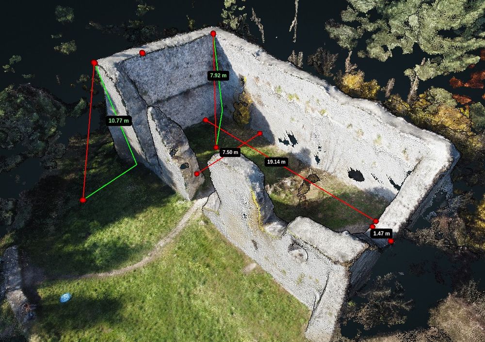
Bydliński zamek to wdzięczny obiekt do ćwiczeń z obsługi #OpenDroneMap #WebODM - obsługa wirtualnej taśmy mierniczej to cenna umiejętność. Ilustracji do podręcznika ciąg dalszy ;)
November 20, 2024 at 9:22 AM
Bydliński zamek to wdzięczny obiekt do ćwiczeń z obsługi #OpenDroneMap #WebODM - obsługa wirtualnej taśmy mierniczej to cenna umiejętność. Ilustracji do podręcznika ciąg dalszy ;)
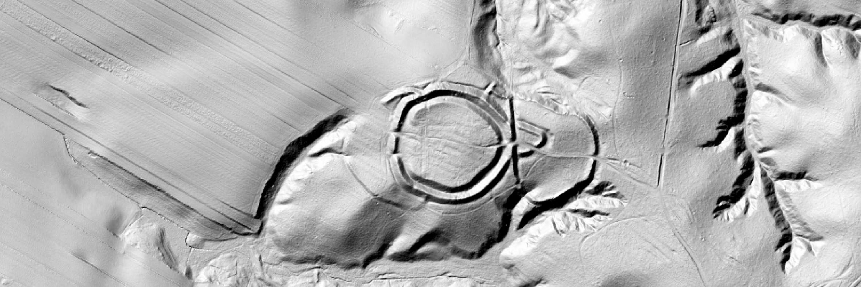
Mosty u Jablunkova - Wielki Szaniec. XVI c. #HillfortsWednesday

November 20, 2024 at 5:31 AM
Mosty u Jablunkova - Wielki Szaniec. XVI c. #HillfortsWednesday
Dziś taka wizualizacja krajów europejskich krąży po X. Polska na tle większości z nich jest archipelagiem powiatowych wysepek.
Wiecie co jest fajne? QGIS i dane GUS dotyczące NSP2021, 2 minuty i mamy grafikę. Żadnej magii, tylko widok 3D.
Wiecie co jest fajne? QGIS i dane GUS dotyczące NSP2021, 2 minuty i mamy grafikę. Żadnej magii, tylko widok 3D.

November 19, 2024 at 8:41 PM
Dziś taka wizualizacja krajów europejskich krąży po X. Polska na tle większości z nich jest archipelagiem powiatowych wysepek.
Wiecie co jest fajne? QGIS i dane GUS dotyczące NSP2021, 2 minuty i mamy grafikę. Żadnej magii, tylko widok 3D.
Wiecie co jest fajne? QGIS i dane GUS dotyczące NSP2021, 2 minuty i mamy grafikę. Żadnej magii, tylko widok 3D.
Jeden z zachowanych reliktów zamków bastionowych. A wcześniej miejsce kilku ważnych wydarzeń z okresu piastowskiego. #Swampfort #Danków

November 19, 2024 at 5:33 PM
Jeden z zachowanych reliktów zamków bastionowych. A wcześniej miejsce kilku ważnych wydarzeń z okresu piastowskiego. #Swampfort #Danków
Reposted by Tomasz Nycz
Efektowne naczynia, produkty prowincjonalnorzymskich warsztatów, zwane terra sigilata, docierały także do klientów znad Wisły. Znajdowane bywają u nas na stanowiskach z okresu rzymskiego.
Thread 1/4 Samian ware, or Terra Sigillata is often billed as high status roman pottery but the vast majority of it was made on an industrial scale using mass production methods that would not be out of place in a modern factory. youtu.be/B5hcIA8Sv6c?...

Chippenham zoom in
YouTube video by PottedHistory
youtu.be
November 19, 2024 at 4:22 PM
Efektowne naczynia, produkty prowincjonalnorzymskich warsztatów, zwane terra sigilata, docierały także do klientów znad Wisły. Znajdowane bywają u nas na stanowiskach z okresu rzymskiego.

W Wilkowicach-Bystrej takie znalezisko. W podcieniach dworca kolejowego, kilkanaście takich płyt


November 17, 2024 at 2:18 PM
W Wilkowicach-Bystrej takie znalezisko. W podcieniach dworca kolejowego, kilkanaście takich płyt