webberweather.com
Almost a perfect match overall.
The westerly low-level wind anomalies deep in the Warm Pool are doing a lot of damage already to our current La Nina state


Almost a perfect match overall.
The westerly low-level wind anomalies deep in the Warm Pool are doing a lot of damage already to our current La Nina state
The Warm Pool is plenty strong enough for El Niño later this year
Note that 30C SSTs are centered ~160E & extend to nearly the dateline below the equator


The Warm Pool is plenty strong enough for El Niño later this year
Note that 30C SSTs are centered ~160E & extend to nearly the dateline below the equator
Note the Eq. Rossby Wave ~150-160E in the Eq. Pacific in both images, where 2 anomalous centers of convective heating straddle the equator. That’s usually how you get -EPO in winter


Note the Eq. Rossby Wave ~150-160E in the Eq. Pacific in both images, where 2 anomalous centers of convective heating straddle the equator. That’s usually how you get -EPO in winter
This year has a classic negative N Pacific Oscillation (-NPO) pattern that often precedes El Nino events in the following calendar year
See Vimont et al (2003):
journals.ametsoc.org/view/journal...


This year has a classic negative N Pacific Oscillation (-NPO) pattern that often precedes El Nino events in the following calendar year
See Vimont et al (2003):
journals.ametsoc.org/view/journal...

Notice the thermocline is quickly deepening and the subsurface anomalies are beginning to advance eastward over the West-Central Equatorial Pacific.
Notice the thermocline is quickly deepening and the subsurface anomalies are beginning to advance eastward over the West-Central Equatorial Pacific.
A downwelling Kelvin Wave is forming over the West Pacific & will help eventually destroy La Nina in a few months or so.


A downwelling Kelvin Wave is forming over the West Pacific & will help eventually destroy La Nina in a few months or so.
Results came back negative fortunately & I feel better this morning w/ the occasional palpitation still
Hopefully when I see the cardiologist they can diagnose the issue 🙏
Results came back negative fortunately & I feel better this morning w/ the occasional palpitation still
Hopefully when I see the cardiologist they can diagnose the issue 🙏
Surely, this must be a trap.


Surely, this must be a trap.
That to me is a very telling of how hard the atmosphere is pushing the ocean away from La Niña & possibly towards an El Niño state this coming spring or summer


That to me is a very telling of how hard the atmosphere is pushing the ocean away from La Niña & possibly towards an El Niño state this coming spring or summer
This will trigger a downwelling oceanic kelvin wave that should destroy La Niña ~3 months from now & begin moving the ocean towards El Niño conditions

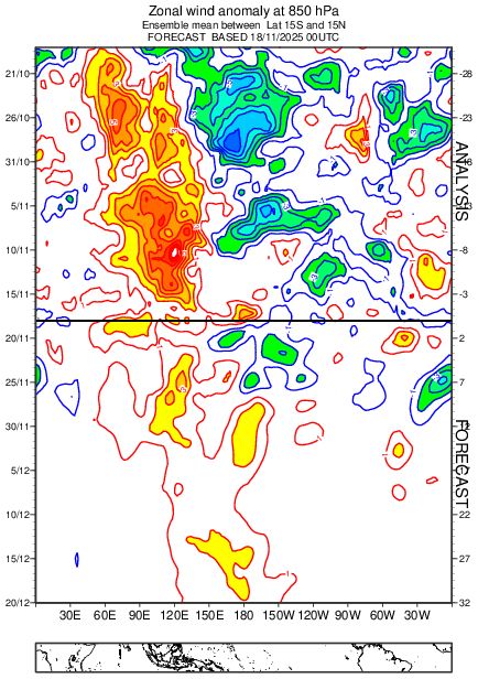
This will trigger a downwelling oceanic kelvin wave that should destroy La Niña ~3 months from now & begin moving the ocean towards El Niño conditions
In the grand scheme of things, El Nino is likely knocking on the door 🚪


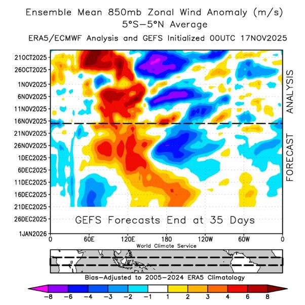
In the grand scheme of things, El Nino is likely knocking on the door 🚪
An annual archive of polar cap geopotential height anomalies going back to 1940 using ERA-5 & a 30-year sliding climatology
👀
hebweather.net/prod/gph_arc...

An annual archive of polar cap geopotential height anomalies going back to 1940 using ERA-5 & a 30-year sliding climatology
👀
hebweather.net/prod/gph_arc...
They concluded that the warm Tropical Atlantic was the primary culprit
The partial regression analysis (left) & AGCM forcing (right) are pretty telling
www.nature.com/articles/s41...


They concluded that the warm Tropical Atlantic was the primary culprit
The partial regression analysis (left) & AGCM forcing (right) are pretty telling
www.nature.com/articles/s41...


A large build-up of westerly momentum (+U) in the tropics is being supplanted by a West Pac MJO orbit & repeated bouts of positive E Asia Mtn Torque (+EAMT) fluxing/squeezing +U equatorward


A large build-up of westerly momentum (+U) in the tropics is being supplanted by a West Pac MJO orbit & repeated bouts of positive E Asia Mtn Torque (+EAMT) fluxing/squeezing +U equatorward
Note how this yr & 1981 have a big & slow westerly wind burst over the Indian Ocean & Maritime Continent in Oct-Nov that moved into the Pacific in Dec

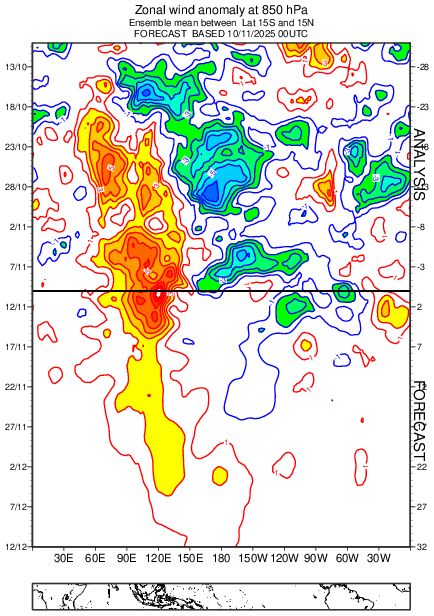
Note how this yr & 1981 have a big & slow westerly wind burst over the Indian Ocean & Maritime Continent in Oct-Nov that moved into the Pacific in Dec


A faster-than-usual start to winter over the East-Central US with plenty of high-latitude blocking


A faster-than-usual start to winter over the East-Central US with plenty of high-latitude blocking
The extreme -IOD we're currently seeing (right) is about to collapse because the warm water in the Equatorial Indian Ocean will get flushed into the tropical West Pac at depth over the next month in this MJO event's westerly wind burst (left)


The extreme -IOD we're currently seeing (right) is about to collapse because the warm water in the Equatorial Indian Ocean will get flushed into the tropical West Pac at depth over the next month in this MJO event's westerly wind burst (left)
I replicated Gray et al (2004)'s analysis except used SLPa from 20CR & isolated -ENSO (left), which is close to the latest Euro weekly forecast (right) journals.ametsoc.org/view/journal...


I replicated Gray et al (2004)'s analysis except used SLPa from 20CR & isolated -ENSO (left), which is close to the latest Euro weekly forecast (right) journals.ametsoc.org/view/journal...
Namely, a warmer-than-normal Maritime Continent & West Pac as well as a Eurasian Snow Cover Dipole.
journals.ametsoc.org/view/journal...


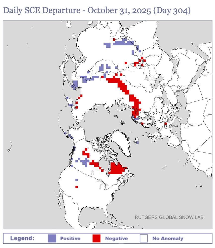

Namely, a warmer-than-normal Maritime Continent & West Pac as well as a Eurasian Snow Cover Dipole.
journals.ametsoc.org/view/journal...
Compare the current global mean SSTa (left) to the Oct-Nov Warm Pool SST [20S-20N, 90-150E] difference for east QBO/cool ENSO winters only (right)


Compare the current global mean SSTa (left) to the Oct-Nov Warm Pool SST [20S-20N, 90-150E] difference for east QBO/cool ENSO winters only (right)
↖️ GOES-19 infrared brightness temp
↗️ GOES-19 visible satellite
↙️ Hurricane hunter planes & flight paths
↘️ Recon-derived flight level wind swath
⬇️ Estimated minimum pressure from recon dropsondes
↖️ GOES-19 infrared brightness temp
↗️ GOES-19 visible satellite
↙️ Hurricane hunter planes & flight paths
↘️ Recon-derived flight level wind swath
⬇️ Estimated minimum pressure from recon dropsondes
I honestly can't help but think the environmental +SRH was a factor for that, as this modeling study from earlier this yr showed:
journals.ametsoc.org/view/journal...

I honestly can't help but think the environmental +SRH was a factor for that, as this modeling study from earlier this yr showed:
journals.ametsoc.org/view/journal...

