


World Historical Gazetteer
@whgazetteer.org
WHG is a platform for linking records about historical places, allowing people to make spatial connections across time and language.
Project Director: @rmostern.bsky.social
Technical Director: @docuracy.co.uk
#DH #LOD #DigitalHumanities #GIS #GIStory
Project Director: @rmostern.bsky.social
Technical Director: @docuracy.co.uk
#DH #LOD #DigitalHumanities #GIS #GIStory
Reposted by World Historical Gazetteer

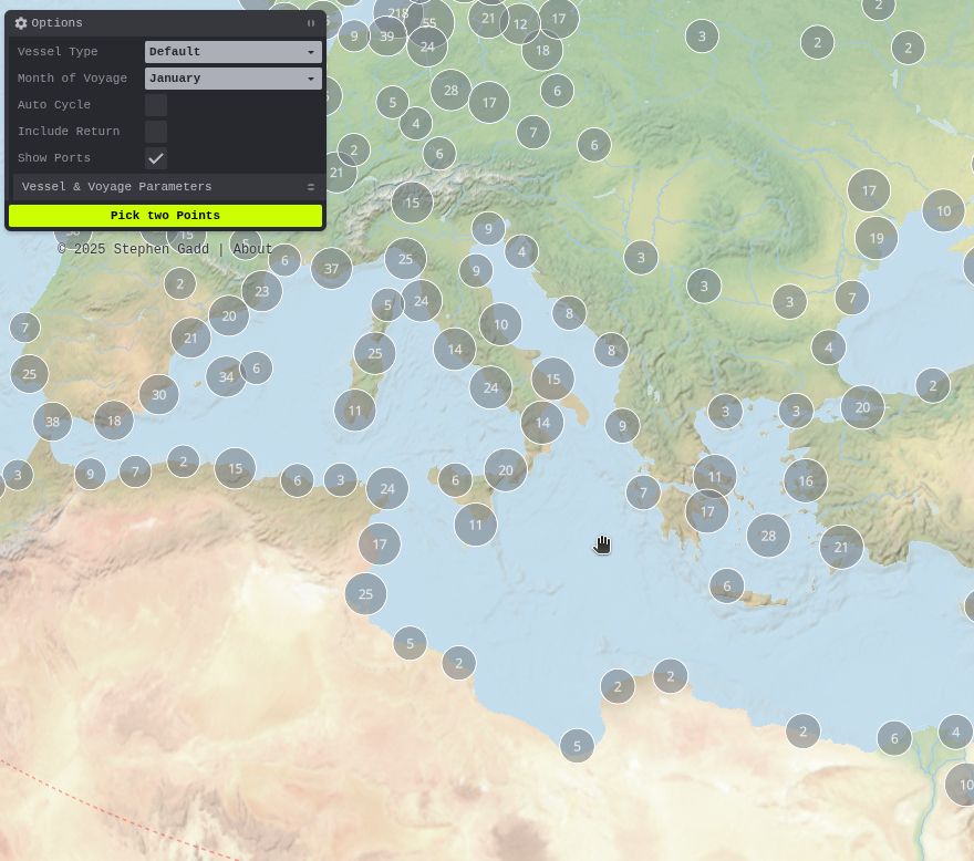
🌍 Ports are now (optionally) shown on the eRutter to help with route picking.
🤔 They're currently fetched from @wikidatacommunity.bsky.social, but this would be a great use case for a @whgazetteer.org temporal API to filter out modern ports and highlight ancient ones.
🤔 They're currently fetched from @wikidatacommunity.bsky.social, but this would be a great use case for a @whgazetteer.org temporal API to filter out modern ports and highlight ancient ones.

July 5, 2025 at 9:57 AM
🌍 Ports are now (optionally) shown on the eRutter to help with route picking.
🤔 They're currently fetched from @wikidatacommunity.bsky.social, but this would be a great use case for a @whgazetteer.org temporal API to filter out modern ports and highlight ancient ones.
🤔 They're currently fetched from @wikidatacommunity.bsky.social, but this would be a great use case for a @whgazetteer.org temporal API to filter out modern ports and highlight ancient ones.
Reposted by World Historical Gazetteer
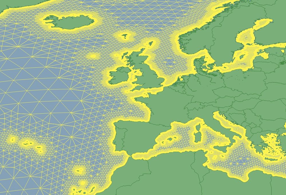
🧭 Building a lightweight sea-routing graph for historical GIS & DH use cases beyond simple port-to-port hops. Edges are weighted for ~5km coastal preference. Aiming for serverless exploration of connectivity in historical maritime trade. ⚓️ #MaritimeHistory #HistoricalGIS #DigitalHumanities

June 16, 2025 at 7:26 PM
🧭 Building a lightweight sea-routing graph for historical GIS & DH use cases beyond simple port-to-port hops. Edges are weighted for ~5km coastal preference. Aiming for serverless exploration of connectivity in historical maritime trade. ⚓️ #MaritimeHistory #HistoricalGIS #DigitalHumanities
Want to work with the WHG team? The Institute for Spatial History Innovation @ Pitt is hiring a full-time Research Associate to be the Digital Data Specialist & Managing Editor of World Historical Gazetteer!
Learn more & apply by July 11: bit.ly/4kAknki
@rmostern.bsky.social @docuracy.co.uk
Learn more & apply by July 11: bit.ly/4kAknki
@rmostern.bsky.social @docuracy.co.uk
Job Opportunity - Research Associate at Institute for Spatial History Innovation | World History Center | University of Pittsburgh
The University of Pittsburgh's Institute for Spatial History Innovation (ISHI) is currently accepting applications for a full-time Research Associate to act as the Digital Data Specialist. The selecte...
bit.ly
June 11, 2025 at 3:05 PM
Want to work with the WHG team? The Institute for Spatial History Innovation @ Pitt is hiring a full-time Research Associate to be the Digital Data Specialist & Managing Editor of World Historical Gazetteer!
Learn more & apply by July 11: bit.ly/4kAknki
@rmostern.bsky.social @docuracy.co.uk
Learn more & apply by July 11: bit.ly/4kAknki
@rmostern.bsky.social @docuracy.co.uk
Reposted by World Historical Gazetteer

This week on my blog I wrote about my methodology in discerning modern placenames from the 16th century counterparts in Thevet’s “Singularitez.” Part of the translation I’m preparing for publication. #earlymodern #frhistory wednesdayblog.org/2025/05/21/o...

On Toponymy
This week, the first in several scribblings about my research: how I connect historic places in my sources with their modern names.
wednesdayblog.org
May 21, 2025 at 1:55 PM
This week on my blog I wrote about my methodology in discerning modern placenames from the 16th century counterparts in Thevet’s “Singularitez.” Part of the translation I’m preparing for publication. #earlymodern #frhistory wednesdayblog.org/2025/05/21/o...
🌍 Recent updates to the WHG user interface give faster loading and globe visualisations.
Image: Indigenous Place Names in North America, a WHG Place Collection at doi.org/10.60681/whg...
Explore more at: whgazetteer.org !
#DigitalHumanities #HistoricalGIS #GeoHumanities #HistoricalGeography
Image: Indigenous Place Names in North America, a WHG Place Collection at doi.org/10.60681/whg...
Explore more at: whgazetteer.org !
#DigitalHumanities #HistoricalGIS #GeoHumanities #HistoricalGeography
![Globe visualisation of Indigenous Place Names in North America, a WHG Place Collection [https://doi.org/10.60681/whg-collection-172]](https://cdn.bsky.app/img/feed_thumbnail/plain/did:plc:stvreqk6efv5wt63rntqmjfk/bafkreiaebejl3mn4riukay5petx7qj773xcgxsnfr46dkfzrouaoyadwwi@jpeg)
April 30, 2025 at 1:38 PM
🌍 Recent updates to the WHG user interface give faster loading and globe visualisations.
Image: Indigenous Place Names in North America, a WHG Place Collection at doi.org/10.60681/whg...
Explore more at: whgazetteer.org !
#DigitalHumanities #HistoricalGIS #GeoHumanities #HistoricalGeography
Image: Indigenous Place Names in North America, a WHG Place Collection at doi.org/10.60681/whg...
Explore more at: whgazetteer.org !
#DigitalHumanities #HistoricalGIS #GeoHumanities #HistoricalGeography
📍What's the Point? Usually (on our maps) a proxy for a place, but we could be more precise, with ... approximation! Might points have a ‘tolerance’ circle? Should polygons show when they contain something more vague? #LinkedPlaces #SpatialData #HistGIS #LinkedPasts github.com/WorldHistori...
Geometry Approximation in LPF · Issue #411 · WorldHistoricalGazetteer/whg3
Proposal for Geometry Approximation Extension to Linked Places Format We propose introducing a new (optional) approximation property in the geometry object to reflect the intended precision of geom...
github.com
November 11, 2024 at 9:29 PM
📍What's the Point? Usually (on our maps) a proxy for a place, but we could be more precise, with ... approximation! Might points have a ‘tolerance’ circle? Should polygons show when they contain something more vague? #LinkedPlaces #SpatialData #HistGIS #LinkedPasts github.com/WorldHistori...