


Stephen Gadd
@docuracy.co.uk
Technical Director & Lead Software Developer, World Historical Gazetteer @whgazetteer.org
Research Associate, Unlocking Upcycled Medieval Data @ihr.bsky.social
GIS Consultant, Layers of London @layersoflondon.bsky.social
Research Associate, Unlocking Upcycled Medieval Data @ihr.bsky.social
GIS Consultant, Layers of London @layersoflondon.bsky.social
Pinned
Stephen Gadd
@docuracy.co.uk
· Jul 4
🪄Historical Sea Routing is now much quicker to load, reload, and compute seasonally-plausible sailing routes, thanks to some behind-the-scenes browser magic. Find a 6500-mile return trip in under 1 second!
🛟 Do you have historical voyage data which might help with calibration? [1/3]
🛟 Do you have historical voyage data which might help with calibration? [1/3]
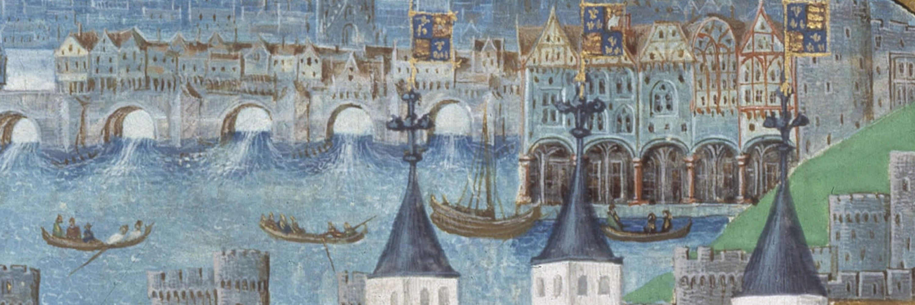
Astonishing. The development of ship design and capacity is something our analysis of London's medieval customs accounts may illuminate. @justincolson.bsky.social @ebenbow.bsky.social @histgrove.bsky.social

December 29, 2025 at 10:38 AM
Astonishing. The development of ship design and capacity is something our analysis of London's medieval customs accounts may illuminate. @justincolson.bsky.social @ebenbow.bsky.social @histgrove.bsky.social
Fun piece by @justincolson.bsky.social and Werner Scheltjens.
My job on this project is to turn messy medieval records into a tidy database so that my colleagues can more easily spot trends in fashion, industry, and commercial networks.
theconversation.com/medieval-lon...
My job on this project is to turn messy medieval records into a tidy database so that my colleagues can more easily spot trends in fashion, industry, and commercial networks.
theconversation.com/medieval-lon...

Medieval Londoners’ cheaply imported mass-produced Christmas gifts look surprisingly familiar
We often imagine medieval life as dull, dirty and short, with little in the way of material comfort or decoration. However, medieval Londoners were importing toys, treats and trinkets by the boatload ...
theconversation.com
December 19, 2025 at 5:34 PM
Fun piece by @justincolson.bsky.social and Werner Scheltjens.
My job on this project is to turn messy medieval records into a tidy database so that my colleagues can more easily spot trends in fashion, industry, and commercial networks.
theconversation.com/medieval-lon...
My job on this project is to turn messy medieval records into a tidy database so that my colleagues can more easily spot trends in fashion, industry, and commercial networks.
theconversation.com/medieval-lon...
Reposted by Stephen Gadd

(4) Linking Knowledge Through Place: ISHI, WHG, and the Future of Gazetteer Collaboration, with @rmostern.bsky.social @docuracy.co.uk, Alexandra Loranna, Palak Vashist. Look at Institute for Spatial History Innovation & World Historical Gazetteer. Register to participate at forms.gle/dzSq2GibT17n...

Linking Knowledge Through Place: ISHI, WHG, and the Future of Gazetteer Collaboration
Description: This activity focuses on advancing collaborative methods for historical place alignment across gazetteers and related datasets within the Pelagios community. It brings together members of...
forms.gle
November 11, 2025 at 4:21 PM
(4) Linking Knowledge Through Place: ISHI, WHG, and the Future of Gazetteer Collaboration, with @rmostern.bsky.social @docuracy.co.uk, Alexandra Loranna, Palak Vashist. Look at Institute for Spatial History Innovation & World Historical Gazetteer. Register to participate at forms.gle/dzSq2GibT17n...
Reposted by Stephen Gadd
Reposted by Stephen Gadd


Reposted by Stephen Gadd

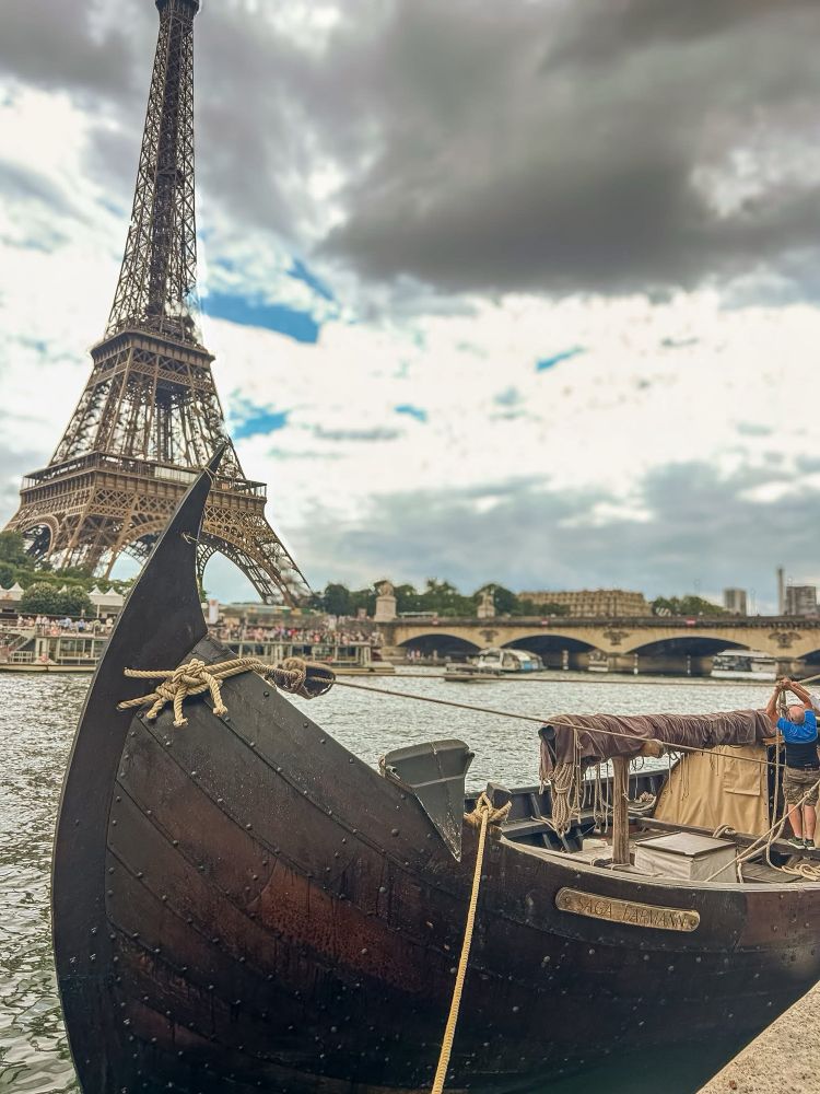
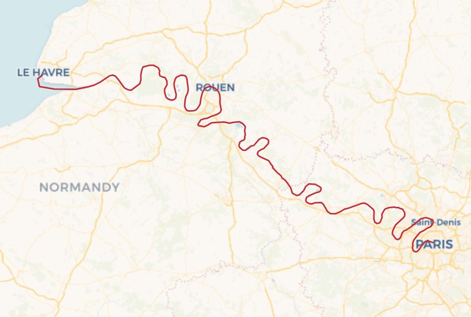
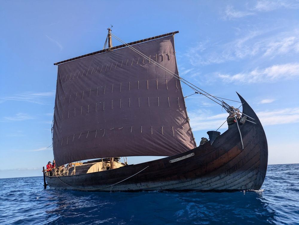
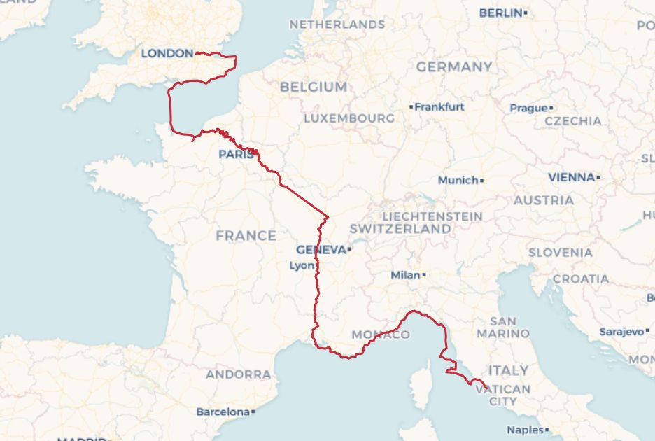
Today I start my research trip sailing down the River Seine from Paris to Honfleur (via a few stops) in a reconstruction of the Klåstad cargo ship built in 998. It’s the penultimate stage in the ship’s journey from Rome to London throughout the summer. I’ll post updates as we go #Saga25 #MedievalSky
August 2, 2025 at 5:19 AM
Today I start my research trip sailing down the River Seine from Paris to Honfleur (via a few stops) in a reconstruction of the Klåstad cargo ship built in 998. It’s the penultimate stage in the ship’s journey from Rome to London throughout the summer. I’ll post updates as we go #Saga25 #MedievalSky
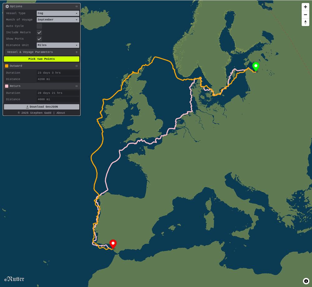
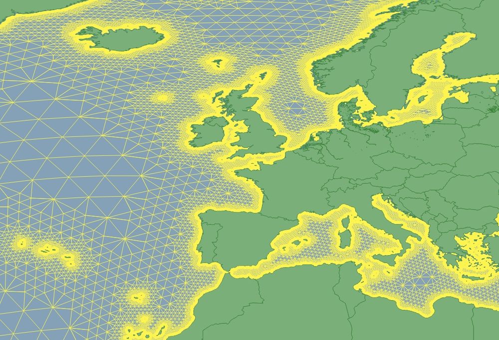
Hours of fun spent realigning my foolishly London-centric assumptions about medieval European trading networks. Shetland, for example, was far from peripheral: a non-Mercator map-projection helps.
I've rebuilt the journey-timed, square-rigged sailing algorithm for docuracy.github.io/Historical_S...
I've rebuilt the journey-timed, square-rigged sailing algorithm for docuracy.github.io/Historical_S...
July 19, 2025 at 7:01 AM
Hours of fun spent realigning my foolishly London-centric assumptions about medieval European trading networks. Shetland, for example, was far from peripheral: a non-Mercator map-projection helps.
I've rebuilt the journey-timed, square-rigged sailing algorithm for docuracy.github.io/Historical_S...
I've rebuilt the journey-timed, square-rigged sailing algorithm for docuracy.github.io/Historical_S...
Thanks, @drpda.bsky.social, this looks like a really useful source, as it includes dates and waypoints for a number of long-distance voyages. 👏
I'd love to get hold of Paula Martin's transcript, though: any suggestions of how I might do that?
I'd love to get hold of Paula Martin's transcript, though: any suggestions of how I might do that?

This is impressive work, I wish I had a use case for it!
For a paleography course I took a decade ago we looked briefly at a journal of a 17th century Scots mariner. It's been digitised at collections.st-andrews.ac.uk/item/journal... Paula Martin made a transcription, but I don't know if it's online
For a paleography course I took a decade ago we looked briefly at a journal of a 17th century Scots mariner. It's been digitised at collections.st-andrews.ac.uk/item/journal... Paula Martin made a transcription, but I don't know if it's online
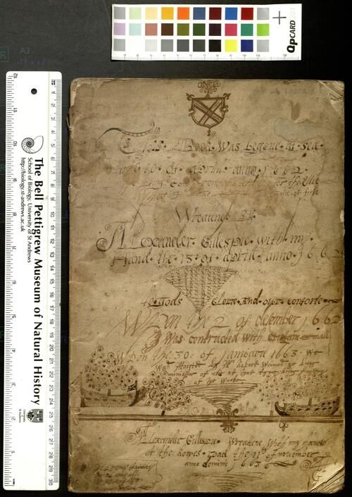
Journal of Alexander Gillespie, skipper in Elie
Manuscript sailing journal of Alexander Gillespie, skipper in Elie, Fife, recording details of his trading voyages between 1662 and 1685.<br/> <br/> <br/>This journal records voyages undertaken by Ale...
collections.st-andrews.ac.uk
July 5, 2025 at 10:13 AM
Thanks, @drpda.bsky.social, this looks like a really useful source, as it includes dates and waypoints for a number of long-distance voyages. 👏
I'd love to get hold of Paula Martin's transcript, though: any suggestions of how I might do that?
I'd love to get hold of Paula Martin's transcript, though: any suggestions of how I might do that?
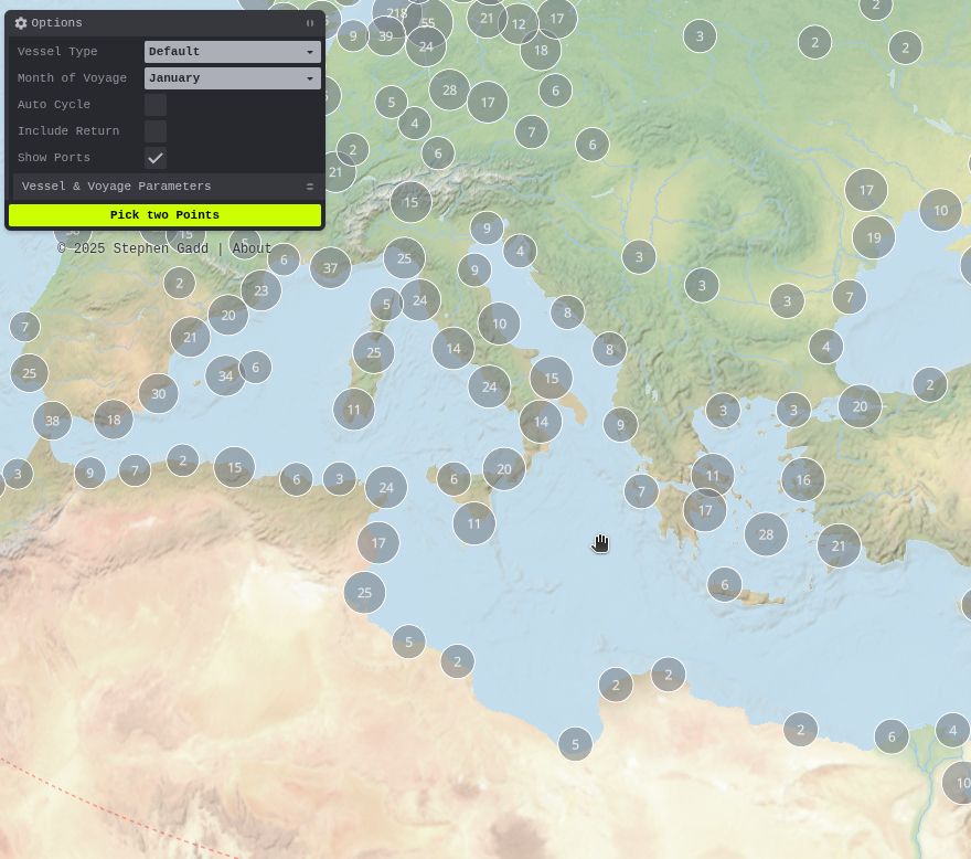
🌍 Ports are now (optionally) shown on the eRutter to help with route picking.
🤔 They're currently fetched from @wikidatacommunity.bsky.social, but this would be a great use case for a @whgazetteer.org temporal API to filter out modern ports and highlight ancient ones.
🤔 They're currently fetched from @wikidatacommunity.bsky.social, but this would be a great use case for a @whgazetteer.org temporal API to filter out modern ports and highlight ancient ones.

July 5, 2025 at 9:57 AM
🌍 Ports are now (optionally) shown on the eRutter to help with route picking.
🤔 They're currently fetched from @wikidatacommunity.bsky.social, but this would be a great use case for a @whgazetteer.org temporal API to filter out modern ports and highlight ancient ones.
🤔 They're currently fetched from @wikidatacommunity.bsky.social, but this would be a great use case for a @whgazetteer.org temporal API to filter out modern ports and highlight ancient ones.
🪄Historical Sea Routing is now much quicker to load, reload, and compute seasonally-plausible sailing routes, thanks to some behind-the-scenes browser magic. Find a 6500-mile return trip in under 1 second!
🛟 Do you have historical voyage data which might help with calibration? [1/3]
🛟 Do you have historical voyage data which might help with calibration? [1/3]
July 4, 2025 at 9:07 PM
🪄Historical Sea Routing is now much quicker to load, reload, and compute seasonally-plausible sailing routes, thanks to some behind-the-scenes browser magic. Find a 6500-mile return trip in under 1 second!
🛟 Do you have historical voyage data which might help with calibration? [1/3]
🛟 Do you have historical voyage data which might help with calibration? [1/3]
🌍 I've just published this here docuracy.github.io/Historical_S... for anyone to play with.
Screenshots, code, and caveats at github.com/docuracy/His....
Screenshots, code, and caveats at github.com/docuracy/His....
July 2, 2025 at 6:46 PM
🌍 I've just published this here docuracy.github.io/Historical_S... for anyone to play with.
Screenshots, code, and caveats at github.com/docuracy/His....
Screenshots, code, and caveats at github.com/docuracy/His....
🧭 Building a lightweight sea-routing graph for historical GIS & DH use cases beyond simple port-to-port hops. Edges are weighted for ~5km coastal preference. Aiming for serverless exploration of connectivity in historical maritime trade. ⚓️ #MaritimeHistory #HistoricalGIS #DigitalHumanities

June 16, 2025 at 7:26 PM
🧭 Building a lightweight sea-routing graph for historical GIS & DH use cases beyond simple port-to-port hops. Edges are weighted for ~5km coastal preference. Aiming for serverless exploration of connectivity in historical maritime trade. ⚓️ #MaritimeHistory #HistoricalGIS #DigitalHumanities
Reposted by Stephen Gadd

Want to work with the WHG team? The Institute for Spatial History Innovation @ Pitt is hiring a full-time Research Associate to be the Digital Data Specialist & Managing Editor of World Historical Gazetteer!
Learn more & apply by July 11: bit.ly/4kAknki
@rmostern.bsky.social @docuracy.co.uk
Learn more & apply by July 11: bit.ly/4kAknki
@rmostern.bsky.social @docuracy.co.uk
Job Opportunity - Research Associate at Institute for Spatial History Innovation | World History Center | University of Pittsburgh
The University of Pittsburgh's Institute for Spatial History Innovation (ISHI) is currently accepting applications for a full-time Research Associate to act as the Digital Data Specialist. The selecte...
bit.ly
June 11, 2025 at 3:05 PM
Want to work with the WHG team? The Institute for Spatial History Innovation @ Pitt is hiring a full-time Research Associate to be the Digital Data Specialist & Managing Editor of World Historical Gazetteer!
Learn more & apply by July 11: bit.ly/4kAknki
@rmostern.bsky.social @docuracy.co.uk
Learn more & apply by July 11: bit.ly/4kAknki
@rmostern.bsky.social @docuracy.co.uk
Reposted by Stephen Gadd
Medieval England’s Road Network Mapped Using the Gough Map.
www.medievalists.net/2025/05/medi...
www.medievalists.net/2025/05/medi...

Medieval England’s Road Network Mapped Using the Gough Map - Medievalists.net
A new study uses the Gough Map to reconstruct medieval England’s road network, revealing how Roman routes shaped travel for centuries.
www.medievalists.net
May 11, 2025 at 8:19 AM
Medieval England’s Road Network Mapped Using the Gough Map.
www.medievalists.net/2025/05/medi...
www.medievalists.net/2025/05/medi...
Reposted by Stephen Gadd
🌍 Recent updates to the WHG user interface give faster loading and globe visualisations.
Image: Indigenous Place Names in North America, a WHG Place Collection at doi.org/10.60681/whg...
Explore more at: whgazetteer.org !
#DigitalHumanities #HistoricalGIS #GeoHumanities #HistoricalGeography
Image: Indigenous Place Names in North America, a WHG Place Collection at doi.org/10.60681/whg...
Explore more at: whgazetteer.org !
#DigitalHumanities #HistoricalGIS #GeoHumanities #HistoricalGeography
![Globe visualisation of Indigenous Place Names in North America, a WHG Place Collection [https://doi.org/10.60681/whg-collection-172]](https://cdn.bsky.app/img/feed_thumbnail/plain/did:plc:stvreqk6efv5wt63rntqmjfk/bafkreiaebejl3mn4riukay5petx7qj773xcgxsnfr46dkfzrouaoyadwwi@jpeg)
April 30, 2025 at 1:38 PM
🌍 Recent updates to the WHG user interface give faster loading and globe visualisations.
Image: Indigenous Place Names in North America, a WHG Place Collection at doi.org/10.60681/whg...
Explore more at: whgazetteer.org !
#DigitalHumanities #HistoricalGIS #GeoHumanities #HistoricalGeography
Image: Indigenous Place Names in North America, a WHG Place Collection at doi.org/10.60681/whg...
Explore more at: whgazetteer.org !
#DigitalHumanities #HistoricalGIS #GeoHumanities #HistoricalGeography
Reposted by Stephen Gadd

Discover 17th century travel through the eyes of John Walker in our new release. Edited by Anthea Jones.
www.hobnobpress.co.uk/books/p/john...
www.hobnobpress.co.uk/books/p/john...
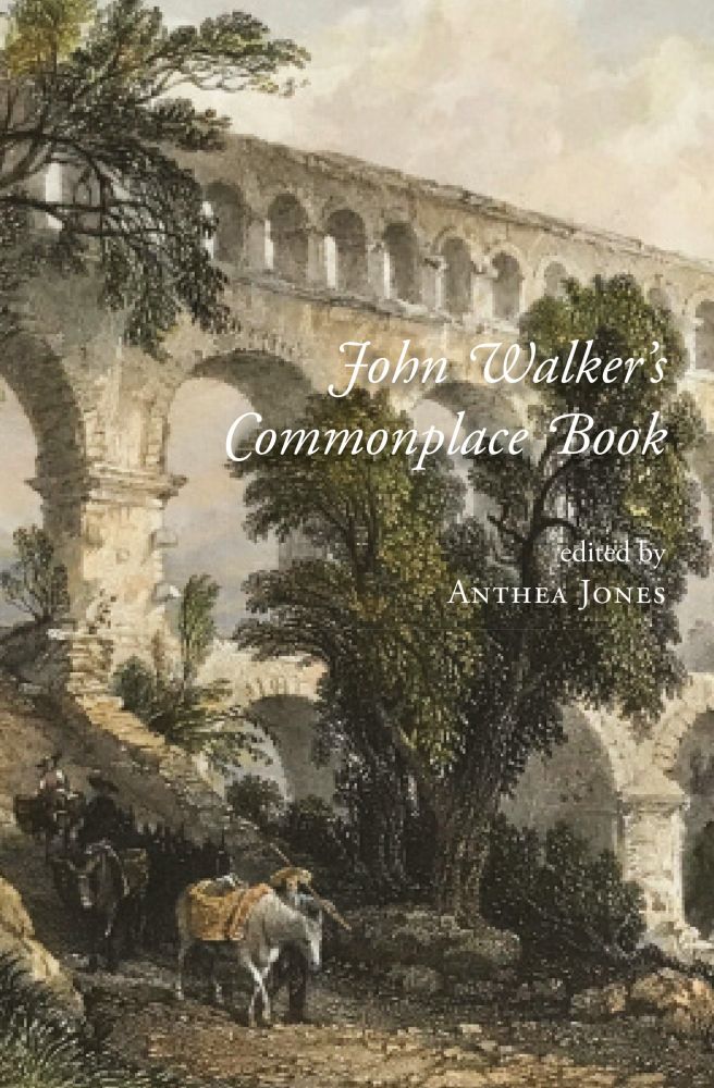
John Walker's Commonplace Book: A Traveller in the 1670s, edited by Anthea Jones — Hobnob Press
Travelling for pleasure in the 1670s required plenty of stamina. John Walker, a well-to-do country gentleman in his early thirties, rode many miles on horseback through England, Wales and Scotland, an...
www.hobnobpress.co.uk
March 31, 2025 at 9:12 PM
Discover 17th century travel through the eyes of John Walker in our new release. Edited by Anthea Jones.
www.hobnobpress.co.uk/books/p/john...
www.hobnobpress.co.uk/books/p/john...
👇Results from my latest version of desCartes, a hybrid machine learning system for detecting roads on old maps. Its 0.76 IoU score for roads is 31% better than the closest benchmark. 🤯
Preprint forthcoming on arXiv.
Preprint forthcoming on arXiv.


March 30, 2025 at 8:32 PM
👇Results from my latest version of desCartes, a hybrid machine learning system for detecting roads on old maps. Its 0.76 IoU score for roads is 31% better than the closest benchmark. 🤯
Preprint forthcoming on arXiv.
Preprint forthcoming on arXiv.
Reposted by Stephen Gadd

The 2025 Richard Deswarte Prize in Digital History celebrates the best of digital history internationally. You have until 30 May to nominate your work or work you love. Please consider doing so. ihrdighist.blogs.sas.ac.uk/2021/12/the-... #dhist

The 2025 Richard Deswarte Prize in Digital History - Digital History Seminar
**SUBMIT HERE BY 30 MAY** Richard Deswarte (1965-2021) was one of the founding convenors of the Digital History seminar at the Institute of Historical Research (IHR), University of London, an advocate...
ihrdighist.blogs.sas.ac.uk
March 14, 2025 at 8:07 AM
The 2025 Richard Deswarte Prize in Digital History celebrates the best of digital history internationally. You have until 30 May to nominate your work or work you love. Please consider doing so. ihrdighist.blogs.sas.ac.uk/2021/12/the-... #dhist
Reposted by Stephen Gadd

Really enjoyed working on this with Stan Hinton and would love to get some feedback on methods and findings from anyone out there. All criticicsm welcome, this is what WPs are for!

❕New WP from @alexislitvine.bsky.social and Stan Hinton❕
𝐁𝐞𝐲𝐨𝐧𝐝 𝐬𝐞𝐜𝐭𝐨𝐫𝐬. 𝐀 𝐬𝐮𝐛𝐬𝐞𝐜𝐭𝐨𝐫𝐚𝐥 𝐚𝐧𝐚𝐥𝐲𝐬𝐢𝐬 𝐨𝐟 𝐡𝐢𝐬𝐭𝐨𝐫𝐢𝐜𝐚𝐥 𝐨𝐜𝐜𝐮𝐩𝐚𝐭𝐢𝐨𝐧𝐚𝐥 𝐝𝐚𝐭𝐚 𝐚𝐧𝐝 𝐭𝐡𝐞𝐢𝐫 𝐫𝐞𝐥𝐚𝐭𝐢𝐨𝐧 𝐭𝐨 𝐞𝐜𝐨𝐧𝐨𝐦𝐢𝐜 𝐠𝐫𝐨𝐰𝐭𝐡
𝐁𝐞𝐲𝐨𝐧𝐝 𝐬𝐞𝐜𝐭𝐨𝐫𝐬. 𝐀 𝐬𝐮𝐛𝐬𝐞𝐜𝐭𝐨𝐫𝐚𝐥 𝐚𝐧𝐚𝐥𝐲𝐬𝐢𝐬 𝐨𝐟 𝐡𝐢𝐬𝐭𝐨𝐫𝐢𝐜𝐚𝐥 𝐨𝐜𝐜𝐮𝐩𝐚𝐭𝐢𝐨𝐧𝐚𝐥 𝐝𝐚𝐭𝐚 𝐚𝐧𝐝 𝐭𝐡𝐞𝐢𝐫 𝐫𝐞𝐥𝐚𝐭𝐢𝐨𝐧 𝐭𝐨 𝐞𝐜𝐨𝐧𝐨𝐦𝐢𝐜 𝐠𝐫𝐨𝐰𝐭𝐡
March 3, 2025 at 4:07 PM
Really enjoyed working on this with Stan Hinton and would love to get some feedback on methods and findings from anyone out there. All criticicsm welcome, this is what WPs are for!
Reposted by Stephen Gadd

📣New blog post alert! 📣
Who had access to common land in the past, and how extensive were common rights?
Our latest blog post by Leigh Shaw-Taylor demonstrates that it was not such an open system as we might assume, even before enclosure...
www.campop.geog.cam.ac.uk/blog
#skystorians
Who had access to common land in the past, and how extensive were common rights?
Our latest blog post by Leigh Shaw-Taylor demonstrates that it was not such an open system as we might assume, even before enclosure...
www.campop.geog.cam.ac.uk/blog
#skystorians
The Cambridge Group for the History of Population and Social Structure, Cambridge Top of the Campops: 60 things you didn't know about family, marriage, work, and death since the middle ages
www.campop.geog.cam.ac.uk
February 6, 2025 at 9:42 AM
📣New blog post alert! 📣
Who had access to common land in the past, and how extensive were common rights?
Our latest blog post by Leigh Shaw-Taylor demonstrates that it was not such an open system as we might assume, even before enclosure...
www.campop.geog.cam.ac.uk/blog
#skystorians
Who had access to common land in the past, and how extensive were common rights?
Our latest blog post by Leigh Shaw-Taylor demonstrates that it was not such an open system as we might assume, even before enclosure...
www.campop.geog.cam.ac.uk/blog
#skystorians

Just clocked @Londonist 's rather wonderful coloured-in version of the area around Clerkenwell, from Rocques' 1746 plan of London. open.substack.com/pub/londonis...

In Colour: A Map of Clerkenwell in 1746
My ongoing mission: to colour in one of the great maps of London.
open.substack.com
January 22, 2025 at 10:44 AM
Inventor Alexander Lagerman's beautiful machines in the Matchstick Museum (Tändstickmuseet), Jönköping, including a fairly early (1892) industrial example of non-circular gears. 👌🏻
sv.m.wikipedia.org/wiki/Alexand...
sv.m.wikipedia.org/wiki/Alexand...


January 4, 2025 at 2:42 PM
Inventor Alexander Lagerman's beautiful machines in the Matchstick Museum (Tändstickmuseet), Jönköping, including a fairly early (1892) industrial example of non-circular gears. 👌🏻
sv.m.wikipedia.org/wiki/Alexand...
sv.m.wikipedia.org/wiki/Alexand...
Reposted by Stephen Gadd

Even when the Bayeux Museum closes for renovations in September, you can access the Tapestry online here. A treat for #Skystorians

December 29, 2024 at 3:56 PM
Even when the Bayeux Museum closes for renovations in September, you can access the Tapestry online here. A treat for #Skystorians
Reposted by Stephen Gadd

Today I'm launching #liiive: a new IIIF viewer that puts real-time collaboration front and center. View, annotate, and discuss together as if you're in the same room. Just paste a manifest URL and go! liiive.now 🎄 #DigitalHumanities #IIIF #DH #ArtHistory #Museums
liiive.now
December 23, 2024 at 12:36 PM
Today I'm launching #liiive: a new IIIF viewer that puts real-time collaboration front and center. View, annotate, and discuss together as if you're in the same room. Just paste a manifest URL and go! liiive.now 🎄 #DigitalHumanities #IIIF #DH #ArtHistory #Museums