


Kaitlyn Jesmonth
@wxkaitlynj.bsky.social
Meteorologist 🌦| Graduate Research Assistant ❄️| M.S. University of Illinois Urbana-Champaign ‘25 ⚡️| B.S. SUNY Oswego ‘23 🌊| AMS WAF ☀️| NY🏡| CT🐚| IL ⛈️|
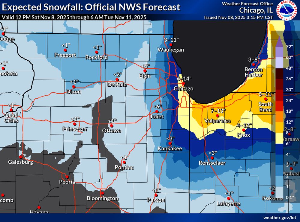
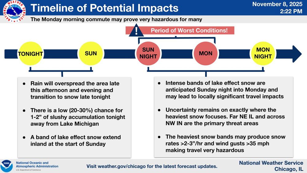
First evidence of thundersnow this evening is on the western periphery of the mesolow, likely over the steel plant near Indiana Dunes National Park. No shortage of tall objects there…more ⚡️ possible as the night goes on near #Chicago


November 10, 2025 at 5:38 AM
First evidence of thundersnow this evening is on the western periphery of the mesolow, likely over the steel plant near Indiana Dunes National Park. No shortage of tall objects there…more ⚡️ possible as the night goes on near #Chicago


(1/4) Lots of talk about the potential for anomalously cold temps and lake-effect precip (snow?) next week.
Details remain uncertain at this lead time, however EOF analysis can provide some insight. Right now, the largest upper-level pattern differences in the models lie in the trough amplitude...
Details remain uncertain at this lead time, however EOF analysis can provide some insight. Right now, the largest upper-level pattern differences in the models lie in the trough amplitude...

November 4, 2025 at 3:17 AM
(1/4) Lots of talk about the potential for anomalously cold temps and lake-effect precip (snow?) next week.
Details remain uncertain at this lead time, however EOF analysis can provide some insight. Right now, the largest upper-level pattern differences in the models lie in the trough amplitude...
Details remain uncertain at this lead time, however EOF analysis can provide some insight. Right now, the largest upper-level pattern differences in the models lie in the trough amplitude...
Before and after #HurricaneMelissa …ocean upwelling viewed from NOAA-21


October 29, 2025 at 9:43 PM
Before and after #HurricaneMelissa …ocean upwelling viewed from NOAA-21
Whoa 63 dBZ showing up in the lake-effect rain band north of Cleveland, OH this evening!! Likely graupel in there and checkout that lightning #ohwx

October 23, 2025 at 1:07 AM
Whoa 63 dBZ showing up in the lake-effect rain band north of Cleveland, OH this evening!! Likely graupel in there and checkout that lightning #ohwx
First snow of the season for the high peaks of New England tonight? ❄️ @professorpowder.bsky.social


October 15, 2025 at 3:00 PM
First snow of the season for the high peaks of New England tonight? ❄️ @professorpowder.bsky.social
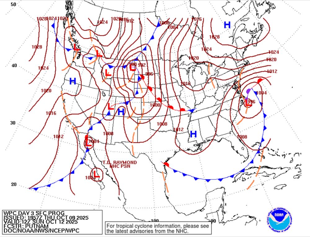
This may be one of the first true tests of the Euro AIFS with a warm-core Nor’easter.
Interestingly, the latest 12z run of the deterministic Euro is very different than the AI version. With such a complex meteorology setup it will be interesting to see how this pans out.
Interestingly, the latest 12z run of the deterministic Euro is very different than the AI version. With such a complex meteorology setup it will be interesting to see how this pans out.


October 10, 2025 at 7:47 PM
This may be one of the first true tests of the Euro AIFS with a warm-core Nor’easter.
Interestingly, the latest 12z run of the deterministic Euro is very different than the AI version. With such a complex meteorology setup it will be interesting to see how this pans out.
Interestingly, the latest 12z run of the deterministic Euro is very different than the AI version. With such a complex meteorology setup it will be interesting to see how this pans out.
Reposted by Kaitlyn Jesmonth

Read the latest key messages regarding the development of a strong coastal low this weekend. Significant coastal impacts are expected along much of the U.S. East Coast through early next week.
Find your local forecast office to keep up with the latest at weather.gov.
Find your local forecast office to keep up with the latest at weather.gov.

October 10, 2025 at 2:43 PM
Read the latest key messages regarding the development of a strong coastal low this weekend. Significant coastal impacts are expected along much of the U.S. East Coast through early next week.
Find your local forecast office to keep up with the latest at weather.gov.
Find your local forecast office to keep up with the latest at weather.gov.
October 🤝 warm-core Nor’easters


October 10, 2025 at 2:55 AM
October 🤝 warm-core Nor’easters
Ah that time of year when you can see lake-effect snow 300+ hours on the GFS is back 🙌

October 6, 2025 at 5:54 PM
Ah that time of year when you can see lake-effect snow 300+ hours on the GFS is back 🙌

Reposted by Kaitlyn Jesmonth

Greetings from the CliMAS Fall 2025 Welcome BBQ!

August 28, 2025 at 11:58 PM
Greetings from the CliMAS Fall 2025 Welcome BBQ!
And we’re back! Day 1 of PhD classes ✅
Ready to start this journey and all that’s to come!
Ready to start this journey and all that’s to come!

August 26, 2025 at 12:54 AM
And we’re back! Day 1 of PhD classes ✅
Ready to start this journey and all that’s to come!
Ready to start this journey and all that’s to come!
More footage of the incredible lightning in Champaign last night. This is in slow motion.
Lasted like this for almost a full hour after the passage of a line of thunderstorms!! #ilwx
Lasted like this for almost a full hour after the passage of a line of thunderstorms!! #ilwx
August 17, 2025 at 1:31 PM
More footage of the incredible lightning in Champaign last night. This is in slow motion.
Lasted like this for almost a full hour after the passage of a line of thunderstorms!! #ilwx
Lasted like this for almost a full hour after the passage of a line of thunderstorms!! #ilwx
Reposted by Kaitlyn Jesmonth

Incredible +CG flash!! Negative leaders propagate right to left incloud, then a positive leader develops downward from the decaying negative leader causing a +CG return stroke. Positive leaders with recoil leaders visible below cloud base following the return stroke.
Tonight featured some of the most incredible lightning I’ve ever captured. Taken from Champaign, IL after thunderstorms departed the area!!⚡️ #ilwx @deeplycloudy.bsky.social @stephanieway.bsky.social @frqltg.bsky.social
August 17, 2025 at 7:03 AM
Incredible +CG flash!! Negative leaders propagate right to left incloud, then a positive leader develops downward from the decaying negative leader causing a +CG return stroke. Positive leaders with recoil leaders visible below cloud base following the return stroke.
Tonight featured some of the most incredible lightning I’ve ever captured. Taken from Champaign, IL after thunderstorms departed the area!!⚡️ #ilwx @deeplycloudy.bsky.social @stephanieway.bsky.social @frqltg.bsky.social
August 17, 2025 at 5:13 AM
Tonight featured some of the most incredible lightning I’ve ever captured. Taken from Champaign, IL after thunderstorms departed the area!!⚡️ #ilwx @deeplycloudy.bsky.social @stephanieway.bsky.social @frqltg.bsky.social
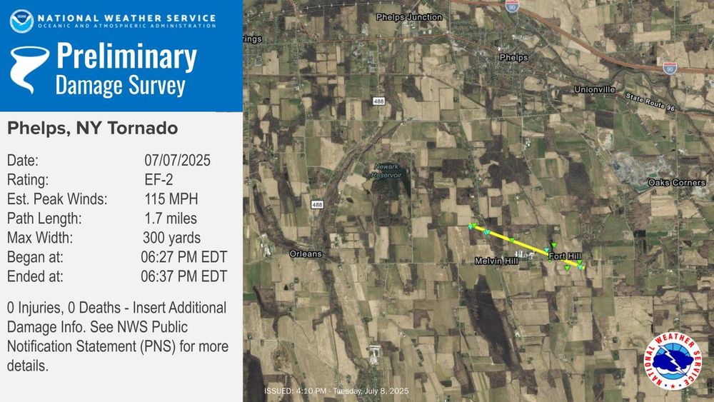
EF-2 tornado confirmed in the Finger Lakes Region of New York yesterday.
Very glad no one was injured here. This storm popped up so quickly and in an area of poor radar coverage! #nywx
Very glad no one was injured here. This storm popped up so quickly and in an area of poor radar coverage! #nywx
July 8, 2025 at 8:47 PM
EF-2 tornado confirmed in the Finger Lakes Region of New York yesterday.
Very glad no one was injured here. This storm popped up so quickly and in an area of poor radar coverage! #nywx
Very glad no one was injured here. This storm popped up so quickly and in an area of poor radar coverage! #nywx
Trace of snow officially goes down in the climate report for Binghamton, NY today from hail accumulation #nywx
BINGHAMTON NY Jul 3
Climate Report:
High: 78
Low: 52
Precip: 0.65"
Snow: Trace Snow Depth: 0"
at Fri, 04 Jul 2025 01:33:22 +0000 via IEMbot
Additional Details Here.
Climate Report:
High: 78
Low: 52
Precip: 0.65"
Snow: Trace Snow Depth: 0"
at Fri, 04 Jul 2025 01:33:22 +0000 via IEMbot
Additional Details Here.
July 4, 2025 at 3:09 AM
Trace of snow officially goes down in the climate report for Binghamton, NY today from hail accumulation #nywx
Honored to have won a student oral presentation award! Thanks #AMS21Meso for a great conference

June 28, 2025 at 12:04 AM
Honored to have won a student oral presentation award! Thanks #AMS21Meso for a great conference
Reposted by Kaitlyn Jesmonth

Join the Committee on Weather Analysis and Forecasting for a free webinar that highlights the important work that NOAA meteorologists throughout the agency do to keep the public safe during severe weather events.
Register here: bit.ly/43RIUvq
Register here: bit.ly/43RIUvq

June 26, 2025 at 6:13 PM
Join the Committee on Weather Analysis and Forecasting for a free webinar that highlights the important work that NOAA meteorologists throughout the agency do to keep the public safe during severe weather events.
Register here: bit.ly/43RIUvq
Register here: bit.ly/43RIUvq
Excited to head to Boise, ID for #AMS21Meso this coming week. I’ll be presenting results from my M.S. work on Thursday. Hope to see you there!
Looking forward to attending @ams-meso.bsky.social for the first time this summer!

June 21, 2025 at 5:32 PM
Excited to head to Boise, ID for #AMS21Meso this coming week. I’ll be presenting results from my M.S. work on Thursday. Hope to see you there!
📍Beehive Trail, Acadia National Park
7:25 am | June 13, 2025
7:25 am | June 13, 2025

June 18, 2025 at 2:30 AM
📍Beehive Trail, Acadia National Park
7:25 am | June 13, 2025
7:25 am | June 13, 2025
Wild weather day here at the Connecticut shoreline!
First it was heavy downpours, then we dried out and had gusty winds, then more rain, now…slight haze from smoke in the upper levels of the atmosphere! #ctwx
First it was heavy downpours, then we dried out and had gusty winds, then more rain, now…slight haze from smoke in the upper levels of the atmosphere! #ctwx


May 31, 2025 at 10:30 PM
Wild weather day here at the Connecticut shoreline!
First it was heavy downpours, then we dried out and had gusty winds, then more rain, now…slight haze from smoke in the upper levels of the atmosphere! #ctwx
First it was heavy downpours, then we dried out and had gusty winds, then more rain, now…slight haze from smoke in the upper levels of the atmosphere! #ctwx