


WX Overlord
@wxoverlord.bsky.social
Air Quality Meteorologist in SE'ern Arizona High Country; Fmr Army Civ & USAF Meteorologist SWO & Sr Met @ FedEx; #NCwx #AZwx #VAwx #AirPower Train BJJ with my kids. Ft. Huachuca, AZ. NC Farm-boy.


Reposted by WX Overlord

New Paper Alert! @climas-ua.bsky.social "The Role of Seasonal Precipitation Sequences in Shaping the Climate of the United States Southwest" - Read about it in their blog here: climas.arizona.edu/news/seasona... #SWClimate @mikecrimmins.bsky.social

October 22, 2025 at 9:00 PM
New Paper Alert! @climas-ua.bsky.social "The Role of Seasonal Precipitation Sequences in Shaping the Climate of the United States Southwest" - Read about it in their blog here: climas.arizona.edu/news/seasona... #SWClimate @mikecrimmins.bsky.social
Reposted by WX Overlord

Imelda and Humberto are churning only about 580 miles from each other tonight. Only 9 other named storms have ever come as close or closer in the Atlantic in the satellite era (since 1966). The last occurrence was Philippe and Rina around this time in 2023.


September 29, 2025 at 11:33 PM
Imelda and Humberto are churning only about 580 miles from each other tonight. Only 9 other named storms have ever come as close or closer in the Atlantic in the satellite era (since 1966). The last occurrence was Philippe and Rina around this time in 2023.
Quick loop & 360-deg of Severe Thunderstorm northeast of Ft. Huachuca - Sierra Vista, Arizona. #severethunderstorm #AZwx #blowingdust #haboob #bldu despite stabilized soils from recent rainfall, outflow winds are still lofting particulates/dust! #TUSwx #PHXwx
September 25, 2025 at 9:01 PM
Quick loop & 360-deg of Severe Thunderstorm northeast of Ft. Huachuca - Sierra Vista, Arizona. #severethunderstorm #AZwx #blowingdust #haboob #bldu despite stabilized soils from recent rainfall, outflow winds are still lofting particulates/dust! #TUSwx #PHXwx
Severe Thunderstorm northeast of Ft. Huachuca - Sierra Vista, Arizona. #severethunderstorm #AZwx #blowingdust #haboob #bldu despite stabilized soils from recent rainfall, outflow winds are still lofting particulates/dust! #TUSwx #PHXwx


September 25, 2025 at 8:58 PM
Severe Thunderstorm northeast of Ft. Huachuca - Sierra Vista, Arizona. #severethunderstorm #AZwx #blowingdust #haboob #bldu despite stabilized soils from recent rainfall, outflow winds are still lofting particulates/dust! #TUSwx #PHXwx
September 1, 2025 at 12:16 AM

Reposted by WX Overlord

An unusually strong summertime #AtmosphericRiver brought AR 3 conditions and heavy rainfall to portions of western Washington last week. #WAwx
See our latest quick summary for a brief synopsis of this event: cw3e.ucsd.edu/wp-content/u....
See our latest quick summary for a brief synopsis of this event: cw3e.ucsd.edu/wp-content/u....

August 19, 2025 at 11:33 PM
An unusually strong summertime #AtmosphericRiver brought AR 3 conditions and heavy rainfall to portions of western Washington last week. #WAwx
See our latest quick summary for a brief synopsis of this event: cw3e.ucsd.edu/wp-content/u....
See our latest quick summary for a brief synopsis of this event: cw3e.ucsd.edu/wp-content/u....


August 19, 2025 at 10:50 PM
Reposted by WX Overlord
This wind field is nuts. Maximum flight-level winds in Hurricane Erin a mere 110 miles from its center. Paging H*Wind, we're about to see some serious IKE 📈


August 19, 2025 at 5:24 PM
This wind field is nuts. Maximum flight-level winds in Hurricane Erin a mere 110 miles from its center. Paging H*Wind, we're about to see some serious IKE 📈
Here’s a good one folks! Blowing dust inbound to Ft. Huachuca, Sierra Vista, AZ, off to the northeast. large #thunderstorms moved down from the Rim, to points south. #AZwx #TUSwx #BLDU #Haboob #Duststorm #monsoon2025
August 13, 2025 at 3:29 AM
Here’s a good one folks! Blowing dust inbound to Ft. Huachuca, Sierra Vista, AZ, off to the northeast. large #thunderstorms moved down from the Rim, to points south. #AZwx #TUSwx #BLDU #Haboob #Duststorm #monsoon2025
August 12, 2025 at 3:55 AM


August 10, 2025 at 4:02 AM
I don't recall seeing this much instability all season - coupled with these theataE & PWAT numbers. Subsidence & CINH diminishing now as well! #AZwx #Monsoon2025


August 9, 2025 at 8:16 PM
I don't recall seeing this much instability all season - coupled with these theataE & PWAT numbers. Subsidence & CINH diminishing now as well! #AZwx #Monsoon2025
Time lapse of the #thunderstorm that sparked the blowing dust warning for Fort Huachuca / Sierra Vista, AZ from TUS WFO. Big cell inbound from northeast; kicked up hella dust! #AZwx #TUSwx #Monsoon2025 #haboob #blowingdust
July 14, 2025 at 2:15 AM
Time lapse of the #thunderstorm that sparked the blowing dust warning for Fort Huachuca / Sierra Vista, AZ from TUS WFO. Big cell inbound from northeast; kicked up hella dust! #AZwx #TUSwx #Monsoon2025 #haboob #blowingdust
#mammatus - Monday's thunderstorm activity. Was too tired to drone it, really should have, though.
#thunderstorm #monsoon #Monsoon2025 #TUSwx #AZwx
#thunderstorm #monsoon #Monsoon2025 #TUSwx #AZwx


July 8, 2025 at 7:15 PM
#mammatus - Monday's thunderstorm activity. Was too tired to drone it, really should have, though.
#thunderstorm #monsoon #Monsoon2025 #TUSwx #AZwx
#thunderstorm #monsoon #Monsoon2025 #TUSwx #AZwx
Reposted by WX Overlord


July 3, 2025 at 10:30 AM
I was sad the past few days b/c I could not find this delightful profile on X anymore. Behold - they are alive and well here on Blue Sky. #ID4 #independenceday
Top of the hour and we have a MAJOR story developing out of Area 51. The order from President Whitmore is clear and intently to the point:
"Nuke 'em, let's nuke the bastards."
"Nuke 'em, let's nuke the bastards."
July 4, 2025 at 1:19 AM
I was sad the past few days b/c I could not find this delightful profile on X anymore. Behold - they are alive and well here on Blue Sky. #ID4 #independenceday
July 2, 2025 at 10:41 PM
Quick time lapse of nearby downburst & outflow. East of Canyon Vista Hosp; kicking up some dust. Got the drone in the hangar just in time to avoid the gusts. #BLDU #AZwx #Monsoon2025 #TUSwx
July 1, 2025 at 12:04 AM
Quick time lapse of nearby downburst & outflow. East of Canyon Vista Hosp; kicking up some dust. Got the drone in the hangar just in time to avoid the gusts. #BLDU #AZwx #Monsoon2025 #TUSwx
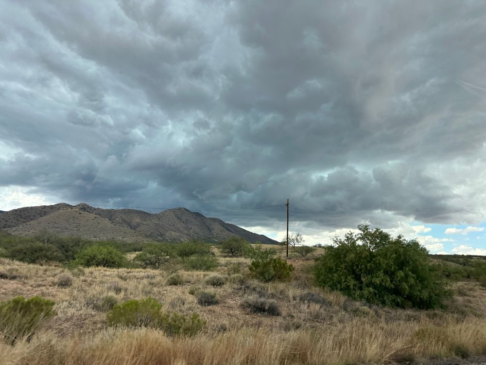
Broke out the drone for some pics of the moisture axis finally shifting a bit west & north. #AZwx #TUSwx #Arizona #Monsoon2025 #ArizonaWeather


June 24, 2025 at 10:38 PM
Broke out the drone for some pics of the moisture axis finally shifting a bit west & north. #AZwx #TUSwx #Arizona #Monsoon2025 #ArizonaWeather
Reposted by WX Overlord

Yesterday afternoon, a severe thunderstorm in northern Colorado dropped a swath of hail that could be seen by GOES-18.
Hail is in the darker red color.
Hail is in the darker red color.
June 5, 2025 at 6:38 PM
Yesterday afternoon, a severe thunderstorm in northern Colorado dropped a swath of hail that could be seen by GOES-18.
Hail is in the darker red color.
Hail is in the darker red color.
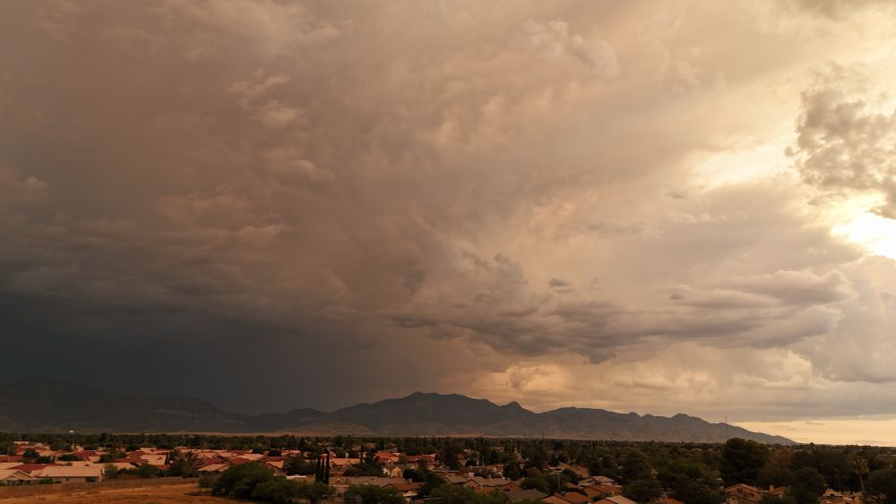
Another round of scary dark clouds 🤠#AZwx

June 2, 2025 at 10:10 PM
Another round of scary dark clouds 🤠#AZwx
First drone storm loiter of the warm season. Trying to stay on target with 25-30kt winds. 16x. Southeastern AZ High Country. Sierra Vista, Arizona. #AZwx #thunderstorm #Arizona #Arizonaweather #TUSwx
June 2, 2025 at 2:06 AM
First drone storm loiter of the warm season. Trying to stay on target with 25-30kt winds. 16x. Southeastern AZ High Country. Sierra Vista, Arizona. #AZwx #thunderstorm #Arizona #Arizonaweather #TUSwx
Reposted by WX Overlord

For hurricane nerds only: my annual roundup of which models did the best. The European and GFS models were the top track models in 2024, with the GFS making better four- and five-day forecasts. The official NHC forecast was tough to beat. yaleclimateconnections.org/2025/05/whic...
Which hurricane models should you trust in 2025? » Yale Climate Connections
How the models did last year, and why you should pay the most heed to the National Hurricane Center forecast.
yaleclimateconnections.org
May 26, 2025 at 11:26 PM
For hurricane nerds only: my annual roundup of which models did the best. The European and GFS models were the top track models in 2024, with the GFS making better four- and five-day forecasts. The official NHC forecast was tough to beat. yaleclimateconnections.org/2025/05/whic...