


48 Contours
@48contours.com
I make 3D maps of mountains and places I love. Handmade in the PNW, and supporting conservation causes.
Reposted by 48 Contours

New post: Comparing LiDAR data from before and after the January 2025 fires in Los Angeles reveals the scale of devastation in ways satellite imagery can’t match.
www.beautifulpublicdata.com/how-lidar-me...
www.beautifulpublicdata.com/how-lidar-me...

How LiDAR measures the toll of climate disasters
Comparing LiDAR data from before and after the January 2025 fires in Los Angeles reveals the scale of devastation in ways satellite imagery can’t match.
www.beautifulpublicdata.com
August 25, 2025 at 2:03 PM
New post: Comparing LiDAR data from before and after the January 2025 fires in Los Angeles reveals the scale of devastation in ways satellite imagery can’t match.
www.beautifulpublicdata.com/how-lidar-me...
www.beautifulpublicdata.com/how-lidar-me...
Reposted by 48 Contours

The Hand-Painted Storefront Signs of Detroit by Ron Miller. “He loves adding color to the neighborhood with his work. He has no website, no email and works all by word of mouth in Detroit.” [kottke.org]
The Hand-Painted Storefront Signs of Detroit by Ron Miller
Ron Miller is one of the most prolific sign painters in Detroit. Photographer Andrew Anderson has collected dozens of images of Miller’s signs from Google Street View.
Ron Miller has been painting signs since 1978. He
kottke.org
August 22, 2025 at 2:42 PM
The Hand-Painted Storefront Signs of Detroit by Ron Miller. “He loves adding color to the neighborhood with his work. He has no website, no email and works all by word of mouth in Detroit.” [kottke.org]
Reposted by 48 Contours
A map of the best places to see the Northern Lights. “Kuril’s analysis culminated in a map highlighting the locations with the best potential to see the northern lights.” [maps.com]

Using Maps to Pinpoint an Aurora
Seeing an aurora is often considered a bucket list experience. Learn how a cartographer used maps to improve his chances.
www.maps.com
July 16, 2025 at 2:08 PM
A map of the best places to see the Northern Lights. “Kuril’s analysis culminated in a map highlighting the locations with the best potential to see the northern lights.” [maps.com]
Long overdue for a summer newsletter. Featured: Seattle maps, upcoming events, and a few thoughts on framing 48contours.com/blogs/news/s...

Summer Maps and Events
Hey friends! I’ve got a few updates to share - new Seattle maps, some upcoming events, and some thoughts on framing. Seattle Last weekend was my first ever Seattle show with Renegade Craft, and it’s w...
48contours.com
June 24, 2025 at 11:35 PM
Long overdue for a summer newsletter. Featured: Seattle maps, upcoming events, and a few thoughts on framing 48contours.com/blogs/news/s...
New maps of Seattle in 10x8 and 20x15 framed options. Seattle was home for a big part of my life, so I really stressed the details on this one. Will debut this weekend. Then will be available on the site at 10am on Monday. Got a few ideas in the hopper - but what do you think I should make next?


June 20, 2025 at 5:58 PM
New maps of Seattle in 10x8 and 20x15 framed options. Seattle was home for a big part of my life, so I really stressed the details on this one. Will debut this weekend. Then will be available on the site at 10am on Monday. Got a few ideas in the hopper - but what do you think I should make next?
Just dropped new maps of the San Juan Islands, Bellingham Bay, and updates to Crater Lake and Mt. St. Helens 48contours.com/blogs/news/n...

March 17, 2025 at 11:37 PM
Just dropped new maps of the San Juan Islands, Bellingham Bay, and updates to Crater Lake and Mt. St. Helens 48contours.com/blogs/news/n...
If it looks like it took forever to assemble…you’d be correct. Really happy with how my San Juan Islands map is turning out. This will be available on the shop and at my upcoming markets soon! #woodart #pnw #sanjuanislands
March 7, 2025 at 11:45 PM
If it looks like it took forever to assemble…you’d be correct. Really happy with how my San Juan Islands map is turning out. This will be available on the shop and at my upcoming markets soon! #woodart #pnw #sanjuanislands
Awesome news. The samish crest open space is a hidden gem in Bellingham @cascadiadaily.com

City of Bellingham to expand Samish Crest Open Space with $4M purchase | Cascadia Daily News
66-acre property acquisition funded by Greenways Levy
www.cascadiadaily.com
February 17, 2025 at 8:13 PM
Awesome news. The samish crest open space is a hidden gem in Bellingham @cascadiadaily.com
Here's how Orcas Island is looking - both at full size (8") and the smaller variant (~4"). Definitely need to ditch the roads in the latter - just too busy and small for it to work.. These will both have several layers of elevation, but just getting a sense of the engraving for now.

February 13, 2025 at 4:58 PM
Here's how Orcas Island is looking - both at full size (8") and the smaller variant (~4"). Definitely need to ditch the roads in the latter - just too busy and small for it to work.. These will both have several layers of elevation, but just getting a sense of the engraving for now.
Starting to model the San Juan Islands too for one of my 3D wood maps. But not sure if I like the look of the roads or not (Red lines). WDYT?

February 5, 2025 at 9:22 PM
Starting to model the San Juan Islands too for one of my 3D wood maps. But not sure if I like the look of the roads or not (Red lines). WDYT?
Getting the GIS work for a Bellingham, WA map done today. Hope to have these produced for some spring markets soon!

February 4, 2025 at 8:14 PM
Getting the GIS work for a Bellingham, WA map done today. Hope to have these produced for some spring markets soon!
Spending a little time on GIS workflow & revisiting an early model of crater lake w/ both topo and bathymetric contours. Lot of steps to this process - and the more I do in GIS, the easier it is in Illustrator and the laser later.

January 27, 2025 at 10:12 PM
Spending a little time on GIS workflow & revisiting an early model of crater lake w/ both topo and bathymetric contours. Lot of steps to this process - and the more I do in GIS, the easier it is in Illustrator and the laser later.
Reposted by 48 Contours

The awe inspiring Grundtvigskirken towers 2 km above icebergs at its base. Sailing through East Greenland's O-fjord, we were blessed with one breathtaking view after another. A privilege to witness!
#bluesky #photography #landscape #travel #nature
#landscapephotography #naturephotography #greenland
#bluesky #photography #landscape #travel #nature
#landscapephotography #naturephotography #greenland
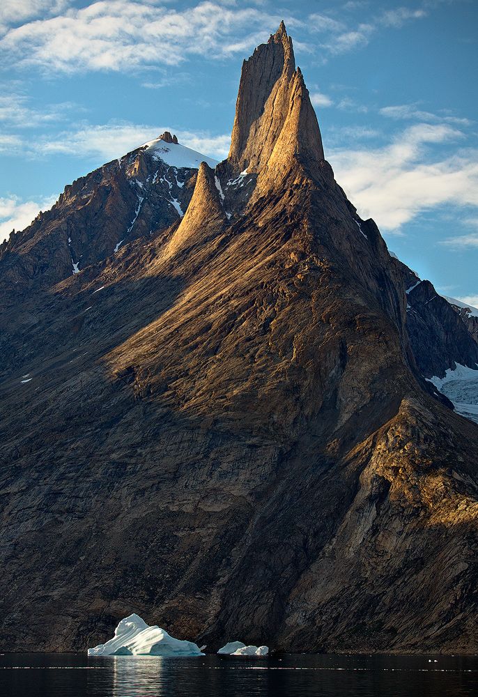
January 26, 2025 at 2:42 PM
The awe inspiring Grundtvigskirken towers 2 km above icebergs at its base. Sailing through East Greenland's O-fjord, we were blessed with one breathtaking view after another. A privilege to witness!
#bluesky #photography #landscape #travel #nature
#landscapephotography #naturephotography #greenland
#bluesky #photography #landscape #travel #nature
#landscapephotography #naturephotography #greenland
New trail runners. Gonna break these in on the chuckanuts tomorrow. Thanks Bbay running!

January 24, 2025 at 9:40 PM
New trail runners. Gonna break these in on the chuckanuts tomorrow. Thanks Bbay running!
Reposted by 48 Contours
A gobsmacking photo of Comet C/2024 G3 (ATLAS) stretched out over the Paranal Observatory in Chile, just after sunset. This comet has since disintegrated after flying too close to the Sun (relatable tbh) and is now a “headless wonder”. [kottke.org]

Comets Are Cool
From astronomer Yuri Beletsky, a photo of Comet C/2024 G3 (ATLAS) arching over ESO’s Paranal Observatory in Chile.
Unfortunately, it seems like the comet disintegrated as it swooped around the Sun, always a danger.
T
kottke.org
January 24, 2025 at 4:36 PM
A gobsmacking photo of Comet C/2024 G3 (ATLAS) stretched out over the Paranal Observatory in Chile, just after sunset. This comet has since disintegrated after flying too close to the Sun (relatable tbh) and is now a “headless wonder”. [kottke.org]
And assembled. About 16 layers in this one, each scaled to 600’ of vertical elevation.

January 23, 2025 at 2:05 AM
And assembled. About 16 layers in this one, each scaled to 600’ of vertical elevation.
Went to add Bluesky to my site footer. RIP. Guess it's going in twitter's slot temporarily until I can figure out how to add it manually.

January 22, 2025 at 7:14 PM
Went to add Bluesky to my site footer. RIP. Guess it's going in twitter's slot temporarily until I can figure out how to add it manually.
Chain lakes loop trail near Mt. Baker from a few months back. Relatively haze free views of Shuksan & Baker, a rarity in our lengthy summer wildfire season.


January 22, 2025 at 4:55 PM
Chain lakes loop trail near Mt. Baker from a few months back. Relatively haze free views of Shuksan & Baker, a rarity in our lengthy summer wildfire season.
Reposted by 48 Contours
Explore an Incredibly Detailed Topographical Map of the Moon. “This is a visualization of the nearly six billion measurement points of the NASA LOLA mission. LOLA was launched to capture high fidelity topographic modeling of the moon’s surface…” [kottke.org]

Explore an Incredibly Detailed Topographical Map of the Moon
Moon Lidar is a visualization of the data collected by NASA’s Lunar Orbiter Laser Altimeter (LOLA) mission. According to this factsheet, the visualization includes nearly six billion measurements.
LOLA data was captur
kottke.org
January 22, 2025 at 4:12 PM
Explore an Incredibly Detailed Topographical Map of the Moon. “This is a visualization of the nearly six billion measurement points of the NASA LOLA mission. LOLA was launched to capture high fidelity topographic modeling of the moon’s surface…” [kottke.org]
Getting started on assembly of my first order of 2025- Mt Baker. My maps cut out flat and I puzzle piece them together. This one will be 20x15”

January 22, 2025 at 1:14 AM
Getting started on assembly of my first order of 2025- Mt Baker. My maps cut out flat and I puzzle piece them together. This one will be 20x15”
Wish the same could be said for my vector software. I started out just using Inkscape for cost reasons - but I eventually hit a wall there and had to jump to Illustrator. Maybe sometime I'll circle back and see if I get Inkscape working well for me again.
January 21, 2025 at 11:51 PM
Wish the same could be said for my vector software. I started out just using Inkscape for cost reasons - but I eventually hit a wall there and had to jump to Illustrator. Maybe sometime I'll circle back and see if I get Inkscape working well for me again.
Planned to switch to ArcGIS Pro this year for my GIS software (was using QGIS which is powerful but a little buggy). But so far I've not been impressed. Super sluggish and UI constantly gets in the way I think I may just double down on QGIS. Bonus points for being open source!
January 21, 2025 at 11:49 PM
Planned to switch to ArcGIS Pro this year for my GIS software (was using QGIS which is powerful but a little buggy). But so far I've not been impressed. Super sluggish and UI constantly gets in the way I think I may just double down on QGIS. Bonus points for being open source!
Recent custom order I made of Lake Tahoe with 1000' contours and depth layers of the lake. This one is 8x10" in a cherry frame. Cheers to USGS for the bathymetric data - not always easy to find for lakes. #topographicmap #woodart

January 21, 2025 at 11:46 PM
Recent custom order I made of Lake Tahoe with 1000' contours and depth layers of the lake. This one is 8x10" in a cherry frame. Cheers to USGS for the bathymetric data - not always easy to find for lakes. #topographicmap #woodart