Anne Goldgar
@annegoldgar.bsky.social
3.6K followers 1.9K following 380 posts
Early modern historian at USC. Cultural history, Netherlands, tulipmania, arctic, history of art, history of science, history of the book, etc. Opinions expressed are mine, not USC’s.
Posts Media Videos Starter Packs
annegoldgar.bsky.social
I tell my students that their humanities degrees qualify them to detect bullshit when they see it. I am putting this skill in practice at the moment.
annegoldgar.bsky.social
I know. Personally I am more invested in bewailing the disappearance of adverbs and the pluperfect.
annegoldgar.bsky.social
Please continue living in this world. You can bear this.
annegoldgar.bsky.social
I think this is correct. When Elena Kagan was Solicitor General, her title was General Kagan. I know it sounds wrong.
Reposted by Anne Goldgar
markhailwood.bsky.social
As you dig out your chunky knitwear from the back of the draw, I know you are wondering: 'How did people prepare for winter 400 years ago?'

Read today's post to find out (and whet your appetite for our new book The Experience of Work in Early Modern England)

manyheadedmonster.com/2025/10/07/t...
The Experience of Work in Early Modern England I: Winter is Coming
This post is part of a series that marks the publication of The Experience of Work in Early Modern England. The book is co-authored by monster head Mark Hailwood, along with Jane Whittle, Hannah Ro…
manyheadedmonster.com
annegoldgar.bsky.social
Why won’t they take an e-ticket?
Reposted by Anne Goldgar
eicathomefinn.bsky.social
'A nationwide survey commissioned by Henry VIII on the property and wealth of 16th century England and Wales is to be made publicly accessible for the first time.

The survey, known as the Valor Ecclesiasticus, set out to discover the financial state of the Church'.
National project launched to rediscover Henry VIII’s long-forgotten ‘Tudor Domesday Book’
A nationwide survey commissioned by Henry VIII on the property and wealth of 16th century England and Wales is to be made publicly accessible for the first time. The survey, known as the Valor Ecclesi...
news.exeter.ac.uk
Reposted by Anne Goldgar
annegoldgar.bsky.social
Interesting — what was the company? I am working on heroism and arctic disaster (though not this disaster) and am curious.
Reposted by Anne Goldgar
greenleejw.bsky.social
Friends, with the world on fire, it feels useless to be here selling my services. But I do need to keep the lights on, and the #maps pay the bills.

So...if you need a map(s) for a book project, let me know! I have space for new commissions.

Here are a few of my favorite maps I've done lately:
1/2
Grayscale map of the Atlantic showing most of the Americas, Europe, and Africa. There are arrows showing the direction of trade, and each arrow has at least one number attached to it. The numbers match a key on the side that lists the products being traded and their place of origin. There are 15 different sets of commodities listed:
1:Midlands & Birmingham: Guns, Gunpowder, Metalware, Silks
2: Liverpool & Lancashire: Cotton-linens
3: Lancashire: Linens, Cottons, Cotton-linens
4: India: Cottons Cowries
5: Midlands & London: Metalware, Silks, Ceramics, Glassware, Guns
6: London & Glasgow: Credit, Shipping Insurance
7: New England: Beef & Pork, Fish, Rum, Wood, Whale products
8: Mid-Atlantic: Grain
9: Chesapeake Colonies: Tobacco
10: Carolinas, Rice, Indigo
11: Caribbean: Sugar, Molasses
12: Brazil: Coffee
13: Brazil: Gold
14: Mexico / Peru: Silver
15: Britain: Grain, Manufactures

The map has a set of grey arrows going from West Africa to the Americas showing the number of enslaved workers transported. The arrows are sized relative to the numbers. The largest arrow shows 6 million enslaved workers going to the Caribbean. 3.5 million went to Africa, 650,000 to the Spanish colonies in Central and South America, and 400,000 to North America.

A key in the bottom right lists a set of African kingdoms that participated in the selling of enslaved workers, including Benin, the Oyo Empire, Dahomey, the Ashanti Confederacy, the Kingdom of Allada, the Kingdom of Whydah, and the Nupe people. These kingdoms are outlined on the map. Greyscale drawing of a floor plan of what looks like the first floor of a house, with ten rooms and a flight of stairs. The title at the bottom reads: "The Magic Bookshop." There are two exterior doors: a front door and a back door. The floor plan is on a tattered piece of paper that looks as if it is being unrolled from the top, so there is a curl of paper, or a scroll, at the bottom. Around the floor plan are four animals. A cat, labeled Angel, is resting on top of floor plan, dangling a paw down. To her left is a huntsman spider named Drusilla. At the bottom of the page on the left is a golden retriever named Willow, sitting behind the scroll like a good boy. On the right side is a cat named Spike, who is sitting on top of the scroll and crushing it like an jerk. Typical dog and cat stuff. There are four piles of books around the outside of the floor plan: two large, and two small

From top left down in a switchback pattern, the rooms are labeled:
Yellow: Books with gold covers
Possibility: Mystery, Crime (where they do the spell)
Exeunt Omnes: Older books (where Kennedy finds the magic book)
The Office (where hazel makes tea)
Bathroom
Gurgler: Sci-fi, Fantasy (where Hazel goes to hide out)
The Scriptorium: More modern books (where Hazel sends Luke to find a book for his niece)
Taboo
The Fishbowl: Romance (where Luke makes a pink and purple bookcase)
Pooh Corner: Children, Young adult (where Bob has his armchair and the silent book club happens)

A label in the central hallway reads: "(where they put a bookcase for Today's Donations). Another label on the stairs reads "Hazel's loft apartment" and there is an arrow pointing up the stairs. Art. A greyscale map of southern Africa showing different biomes. The map map key indicates 7 different biomes: Succulent Karoo; Fynbos; Albany Thicket; India Ocean Coastal Belt; Mixed Woodland; Grassland; Nama-Karoo; and Kalahari Savanna. Each is represented on the may by a different shade of grey, with areas of more rainfall being darker, and areas of less rainfall being lighter. Several of the rivers are labeled, as is the Indian Ocean. Art. Colored map showing the locations of Alderely Edge, done in a fantasy style. The map is drawn to look like an old map done on parchment, with torn edges curling up. Two bars with ribbons wrapped around them form a frame at the top and right sides of the map. The ribbon on top is blue, the one on the right is a dusty red. On the right side of the map, between the frame and the edge, the map is colored turquoise and does not show any land forms. Written in large vertical letters in this space is the maps' title: "The Edge".

The main part of the map is cut with forests and cliffs, and has 13 locations noted. Each location name is in a small frame that looks like a torn piece of parchment. Two roads cut across the map, one labeled Macclesfield Road and the other labeled Artists Lane. They meet in the bottom 3rd of the map by a location called "The Wizard Tearoom."  An arrow at the top left points up one of the roads and has a label reading "to Alderely Edge (village). An arrow a the other end of the road, at the bottom of th emap, reads: "To Macclesfield."
Reposted by Anne Goldgar
speccoll-kuleuven.bsky.social
Exceptionnaly a #asiteoftheweek in Dutch. The Folktale Database of the Low Countries at the Meertens Institute contains over 100,000 stories from the past and present. All genres are represented: fairy tales, sagas, legends, riddles, jokes, urban myths and the like.
Volksverhalenbank van de Lage Landen
De Volksverhalenbank van de Lage Landen van het Meertens Instituut bevat ruim 100.000 verhalen uit heden en verleden. Alle genres zijn vertegenwoordigd: sprookje, sage, legende, raadsel, mop, broodjea...
www.verhalenbank.nl
Reposted by Anne Goldgar
hsmurphy.bsky.social
First post of the new academic year and it's a good one: JOBS! There are THREE fixed-term research jobs in @kingshistory.bsky.social attached to my colleague Francisco Bethencourt's new ERC project on the Visual and Material Culture of New Christians. Please circulate!

#EarlyModern 🗃️
annegoldgar.bsky.social
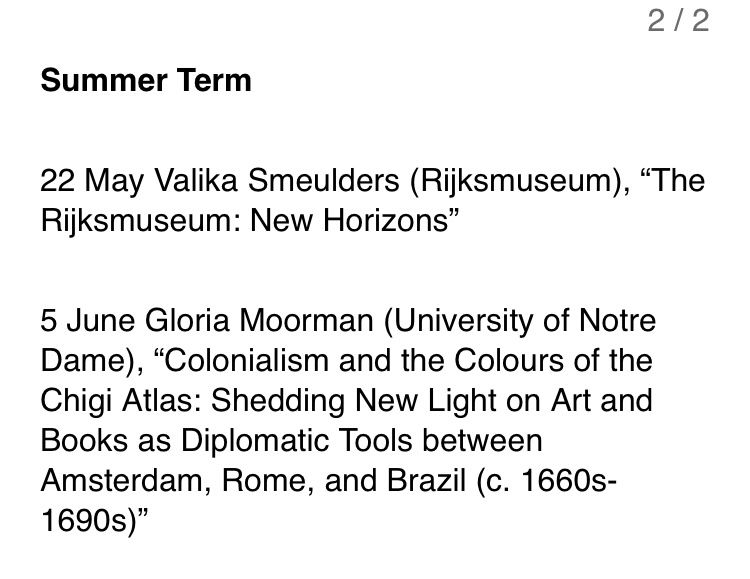
Full program for 2025-6 for the IHR Low Countries Seminar. All meetings both in person and online. To register for any session, go to www.history.ac.uk/seminars/low...
annegoldgar.bsky.social
I get that you like the idea of dead Jews.
annegoldgar.bsky.social
And you clearly are excited by the chance for retribution against Jews. I am sorry for you. You are an antisemite who does not even dare to use your own name while making your bloodthirsty arguments.
annegoldgar.bsky.social
It is hard to tell the difference when so many Palestinians who are not Hamas took part on October 7th, held hostages, and didn’t do a thing to help any hostages.

All figures implying genocide buy into Hamas figures and Hamas propaganda. Most were male combatants. It’s a war, not genocide.
annegoldgar.bsky.social
So you think it’s ok for Jews worldwide to be murdered because of a war a continent away? I mean, I know that’s what globalize the intifada means, and Hamas has certainly put it into practice (eg in Argentina), but most non-Hamas people aren’t so open about their desire to kill Jews.
annegoldgar.bsky.social
There is no genocide. And even if there were, it dies not justify murdering two people who have nothing to do with the conflict. If you can’t tell the difference between British Jews and the Israeli government, you have a serious conceptual problem.
annegoldgar.bsky.social
Also, there is a war going on in Gaza. There is not a war in Manchester, as far as I know.
annegoldgar.bsky.social
a) plenty of Palestinians support Hamas and took part in October 7th. None has helped a hostage.

b) Israel warns Palestinians to get out of the way of its attacks. No one was warned in Manchester.

c) Jews in Manchester have nothing to do with Israeli wars.

Not analogous.