


April Allen-Kirschenman
@aprilmaywx.bsky.social
Meteorologist OU 2023 | Wife | Cat Mom | Opinions my own

( #NWSNorman ) SIGNIFICANT FLOODING RISK - Recent heavy rainfall and an additional 2-4" (isolated 6+") of rain will lead to flooding concerns today and tonight, especially for portions of central and southern Oklahoma. If you encounter flooded roads, turn around don't drown! #okwx #texomawx

April 29, 2025 at 4:28 PM
( #NWSNorman ) SIGNIFICANT FLOODING RISK - Recent heavy rainfall and an additional 2-4" (isolated 6+") of rain will lead to flooding concerns today and tonight, especially for portions of central and southern Oklahoma. If you encounter flooded roads, turn around don't drown! #okwx #texomawx
( #NWSNorman) Here is an update to the flooding potential through the weekend. Multiple rounds of showers and thunderstorms are expected to move through the area, especially across southern and central Oklahoma. Heavy rainfall from these storms could cause flooding. #okwx #txwx

April 3, 2025 at 2:35 AM
( #NWSNorman) Here is an update to the flooding potential through the weekend. Multiple rounds of showers and thunderstorms are expected to move through the area, especially across southern and central Oklahoma. Heavy rainfall from these storms could cause flooding. #okwx #txwx
( #NWSNorman) “4 PM - Here is the latest regarding the severe thunderstorm risk tonight into Wednesday morning.
Make sure you have a way to receive warning information!”
#okwx #texomawx
Make sure you have a way to receive warning information!”
#okwx #texomawx


April 1, 2025 at 9:10 PM
( #NWSNorman) “4 PM - Here is the latest regarding the severe thunderstorm risk tonight into Wednesday morning.
Make sure you have a way to receive warning information!”
#okwx #texomawx
Make sure you have a way to receive warning information!”
#okwx #texomawx
(#NWSNorman) “With the exception of gusty winds, it may not feel like a severe weather day, as it still feels cool outside. However, moisture will continue to increase during the day which is one of the ingredients necessary for severe storms. Stay weather aware today!” #okwx #texomawx
April 1, 2025 at 6:01 PM
(#NWSNorman) “We see the comments after every severe weather event, things like "we were in an enhanced risk and we didn't even get a storm." Here's some reminders about what those outlooks mean (and don't mean) hopefully to help everyone understand their purpose a little better.”

April 1, 2025 at 5:57 PM
(#NWSNorman) “We see the comments after every severe weather event, things like "we were in an enhanced risk and we didn't even get a storm." Here's some reminders about what those outlooks mean (and don't mean) hopefully to help everyone understand their purpose a little better.”
(@NWSNorman) “Severe weather update for this afternoon and tonight. A few thunderstorms may develop along a dryline by mid to late afternoon. If storms develop, large hail, damaging winds and perhaps tornadoes will be possible. Other storms are expected overnight.” #okwx #texomawx


April 1, 2025 at 5:48 PM
Reposted by April Allen-Kirschenman

Oh no, a dreaded *CLICK FOR EMBIGGENATION* day! 2 rounds of storms, the first (and less likely) will be this afternoon and evening along the dryline. Scattered strong supercells may form and have a substantial risk of all severe hazards. ticker.mesonet.org #okwx #okmesonet

April 1, 2025 at 2:32 PM
Oh no, a dreaded *CLICK FOR EMBIGGENATION* day! 2 rounds of storms, the first (and less likely) will be this afternoon and evening along the dryline. Scattered strong supercells may form and have a substantial risk of all severe hazards. ticker.mesonet.org #okwx #okmesonet
Reposted by April Allen-Kirschenman

A reminder of NOAA’s Effect on the National Economy
Their contributions impact all sorts of economic sectors, in addition to providing informative and life-saving information to the public
Their contributions impact all sorts of economic sectors, in addition to providing informative and life-saving information to the public
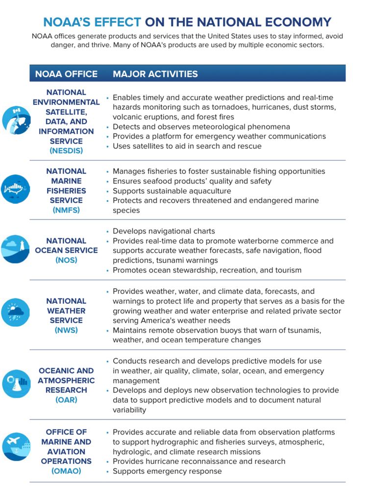
February 7, 2025 at 5:59 PM
A reminder of NOAA’s Effect on the National Economy
Their contributions impact all sorts of economic sectors, in addition to providing informative and life-saving information to the public
Their contributions impact all sorts of economic sectors, in addition to providing informative and life-saving information to the public
Reposted by April Allen-Kirschenman

January 22, 2025 at 1:28 AM

Reposted by April Allen-Kirschenman

Some perspective for people who are saying they hope there is a government shutdown. Government workers are real people. Your friends, your neighbors, even maybe your family. Some of us are still required to work during a shutdown, and guess what? We do not get paid for that work until…(1/2)
December 19, 2024 at 12:50 AM
Some perspective for people who are saying they hope there is a government shutdown. Government workers are real people. Your friends, your neighbors, even maybe your family. Some of us are still required to work during a shutdown, and guess what? We do not get paid for that work until…(1/2)
Reposted by April Allen-Kirschenman
2024 Oklahoma weather in a single graph.
I tell ya, we're saving something up for the last week of the year. It's been too quiet. Be afraid, be very afraid. ticker.mesonet.org #okwx #okmesonet

December 12, 2024 at 4:16 PM
2024 Oklahoma weather in a single graph.
Reposted by April Allen-Kirschenman
So Cal Fire Weather🧵: Portions of Southern CA are under an Extremely Critical (Level 3 of 3) fire weather risk area today due to strong Santa Ana/offshore winds. How does this type of weather event happen? (1/x)

December 10, 2024 at 5:19 PM
So Cal Fire Weather🧵: Portions of Southern CA are under an Extremely Critical (Level 3 of 3) fire weather risk area today due to strong Santa Ana/offshore winds. How does this type of weather event happen? (1/x)
Reposted by April Allen-Kirschenman

Sunset timelapse in Erie confirmed.
November 23, 2024 at 12:27 AM
Sunset timelapse in Erie confirmed.
Reposted by April Allen-Kirschenman

Buoy 46005 is probably the closest to the bomb cyclone this morning and its surface pressure is dropping fast -- 1013mb to 978mb in about the last 24 hours. The main low is still about 100-200 miles south of this buoy, so the central pressure of the system is likely somewhat lower than this.


November 19, 2024 at 7:00 PM
Buoy 46005 is probably the closest to the bomb cyclone this morning and its surface pressure is dropping fast -- 1013mb to 978mb in about the last 24 hours. The main low is still about 100-200 miles south of this buoy, so the central pressure of the system is likely somewhat lower than this.
Reposted by April Allen-Kirschenman

To all my broadcaster friends who are joining up now…don’t forget Alt Text on your images!
Just like broadcast weather coverage can have closed captioning, Alt Text is captioning for your images.
You can even set your profile to require Alt Text before posting so you don’t forget it.
Just like broadcast weather coverage can have closed captioning, Alt Text is captioning for your images.
You can even set your profile to require Alt Text before posting so you don’t forget it.

November 18, 2024 at 12:28 PM
To all my broadcaster friends who are joining up now…don’t forget Alt Text on your images!
Just like broadcast weather coverage can have closed captioning, Alt Text is captioning for your images.
You can even set your profile to require Alt Text before posting so you don’t forget it.
Just like broadcast weather coverage can have closed captioning, Alt Text is captioning for your images.
You can even set your profile to require Alt Text before posting so you don’t forget it.