

Atmospheric Chaos
@atmosphericchaos.bsky.social
Documenting 🌪️🌩️weather, OU Meteorologists & and an MPA: severe weather education & resilience
https://www.atmosphericchaos.com
https://www.atmosphericchaos.com
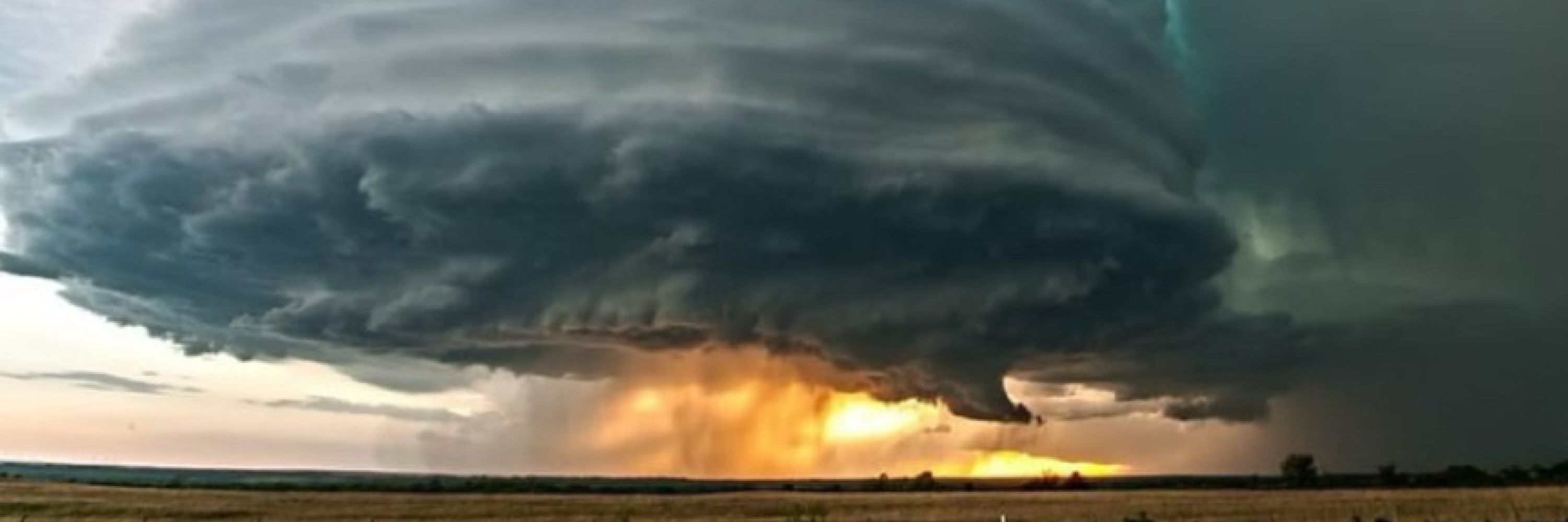
Happy Quake-nado day! 14 years ago already...epic tornadoes in southwest Oklahoma, then a 4.9 magnitude earthquake to finish it off. Just 2 days prior, Oklahoma had it's largest earthquake ever, at 5.7 mag. Fun few days. #okwx
Link to video: youtu.be/SiDyPJcmFCs?...
Link to video: youtu.be/SiDyPJcmFCs?...


November 8, 2025 at 6:25 PM
Happy Quake-nado day! 14 years ago already...epic tornadoes in southwest Oklahoma, then a 4.9 magnitude earthquake to finish it off. Just 2 days prior, Oklahoma had it's largest earthquake ever, at 5.7 mag. Fun few days. #okwx
Link to video: youtu.be/SiDyPJcmFCs?...
Link to video: youtu.be/SiDyPJcmFCs?...
June 26, 2018 - Douglass, KS
Stack-o-pancakes. Last shot I took of this supercell as it was starting weaken at sunset.
Stack-o-pancakes. Last shot I took of this supercell as it was starting weaken at sunset.

November 5, 2025 at 11:26 PM
June 26, 2018 - Douglass, KS
Stack-o-pancakes. Last shot I took of this supercell as it was starting weaken at sunset.
Stack-o-pancakes. Last shot I took of this supercell as it was starting weaken at sunset.
In honor of Halloween, here is the creepiest tornado 🌪️ siren 🚨 sound EVER!! See below in the comments 👇

October 31, 2025 at 7:28 PM
In honor of Halloween, here is the creepiest tornado 🌪️ siren 🚨 sound EVER!! See below in the comments 👇
June 23, 2018 - Hollister, OK
LP supercell at sunset.
LP supercell at sunset.

October 30, 2025 at 9:49 PM
June 23, 2018 - Hollister, OK
LP supercell at sunset.
LP supercell at sunset.
Dropsonde from the NE eyewall at 12:55z from hurricane hunter aircraft currently in the storm has 210 kt winds (241 mph) only maybe 100 meters or so off the surface. 925 mb was at 44m so 907 mb isn’t much higher. That’s just insane. #Melissa #hurricane

October 27, 2025 at 2:41 PM
Dropsonde from the NE eyewall at 12:55z from hurricane hunter aircraft currently in the storm has 210 kt winds (241 mph) only maybe 100 meters or so off the surface. 925 mb was at 44m so 907 mb isn’t much higher. That’s just insane. #Melissa #hurricane

October 26, 2025 at 8:17 PM

October 23, 2025 at 8:59 PM

Launching our severe weather education series! Let us know what you’d be interested in learning more about! Thanks! www.youtube.com/watch?v=f1Dw...

Weathering The Storm
YouTube video by Atmospheric Chaos Storm Chasing
www.youtube.com
October 18, 2025 at 2:20 AM
Launching our severe weather education series! Let us know what you’d be interested in learning more about! Thanks! www.youtube.com/watch?v=f1Dw...
Reposted by Atmospheric Chaos

A severe storm threat is in place for more than 45 million people from northeast Texas to the Ohio River Valley on Saturday.
💨 Damaging winds
🌪️ A few tornadoes &
🧊 Hail are all possible
There is time today to make sure you are prepared. Visit weather.gov/safety for more.
💨 Damaging winds
🌪️ A few tornadoes &
🧊 Hail are all possible
There is time today to make sure you are prepared. Visit weather.gov/safety for more.


October 17, 2025 at 5:53 PM
A severe storm threat is in place for more than 45 million people from northeast Texas to the Ohio River Valley on Saturday.
💨 Damaging winds
🌪️ A few tornadoes &
🧊 Hail are all possible
There is time today to make sure you are prepared. Visit weather.gov/safety for more.
💨 Damaging winds
🌪️ A few tornadoes &
🧊 Hail are all possible
There is time today to make sure you are prepared. Visit weather.gov/safety for more.
Finishing up our severe weather safety & radar training course! What do you guys think we should add? Comment below 👇


September 26, 2025 at 8:44 PM
Finishing up our severe weather safety & radar training course! What do you guys think we should add? Comment below 👇
Reposted by Atmospheric Chaos
A first-of-its-kind Integrated Warning Team forum in collaboration with digital meteorologists will take place the Sunday of #NWAS25 at 3 PM Central!
Watch a livestream of the forum on our YouTube channel: youtube.com/live/UNbXlL6...
Looking forward to this important discussion!
Watch a livestream of the forum on our YouTube channel: youtube.com/live/UNbXlL6...
Looking forward to this important discussion!

August 28, 2025 at 1:23 AM
A first-of-its-kind Integrated Warning Team forum in collaboration with digital meteorologists will take place the Sunday of #NWAS25 at 3 PM Central!
Watch a livestream of the forum on our YouTube channel: youtube.com/live/UNbXlL6...
Looking forward to this important discussion!
Watch a livestream of the forum on our YouTube channel: youtube.com/live/UNbXlL6...
Looking forward to this important discussion!

August 26, 2025 at 1:47 AM


This supercell went on to produce the nighttime Bismarck, North Dakota #supercelk #sunset #photography
July 16, 2025 at 8:43 PM
This supercell went on to produce the nighttime Bismarck, North Dakota #supercelk #sunset #photography
Anvil debris & a bit of mammatus at sunset this weekend! #sunset #photograghy

July 14, 2025 at 10:11 PM
Anvil debris & a bit of mammatus at sunset this weekend! #sunset #photograghy
Just had an epic mammatus sunset north of Rapid City, SD! #sunset #photography

June 26, 2025 at 3:28 AM
Just had an epic mammatus sunset north of Rapid City, SD! #sunset #photography
In Kearney, Nebraska a bit ago! #severethunderstorm #newx

June 25, 2025 at 9:37 PM
In Kearney, Nebraska a bit ago! #severethunderstorm #newx


Played western OK and busted 🙁. But got a beautiful sunset and some local wildlife.


May 18, 2025 at 2:19 AM
Played western OK and busted 🙁. But got a beautiful sunset and some local wildlife.
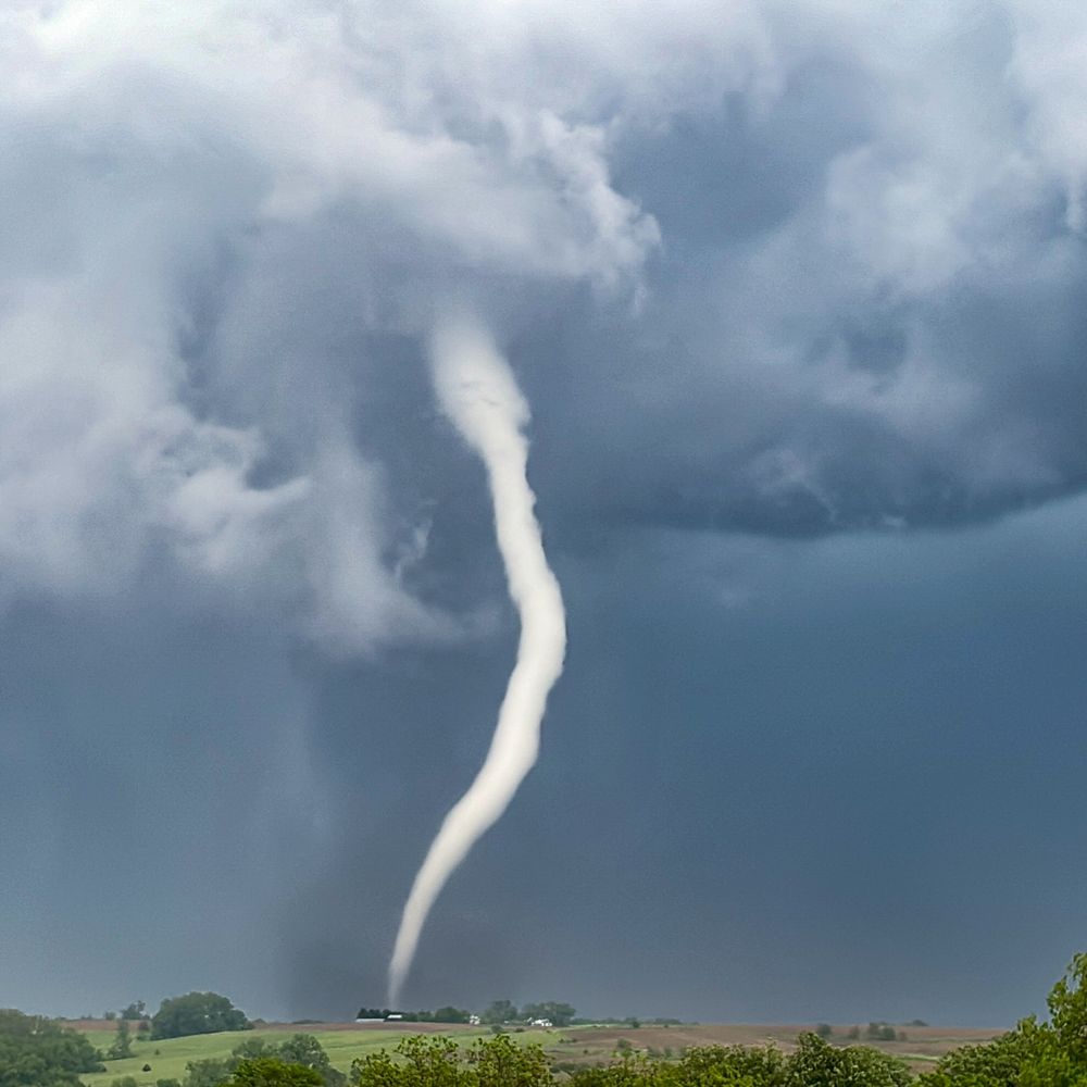
Chasing just west of the same area as the infamous tornado outbreak! #okwx #tornadoes


May 17, 2025 at 8:05 PM
Chasing just west of the same area as the infamous tornado outbreak! #okwx #tornadoes
For many of us in the storm chasing community, May 3rd 1999 was a pivotal moment. (Much more so for the residents of Moore as the F5 tore through the community). Meteorologically this multi -dryline setup was unique and a fascinating case study. #tornadoes

May 4, 2025 at 3:06 AM
For many of us in the storm chasing community, May 3rd 1999 was a pivotal moment. (Much more so for the residents of Moore as the F5 tore through the community). Meteorologically this multi -dryline setup was unique and a fascinating case study. #tornadoes
April 15, 2017 - Protection, KS
Beautiful sunset LP supercell!
Beautiful sunset LP supercell!

April 22, 2025 at 12:16 AM
April 15, 2017 - Protection, KS
Beautiful sunset LP supercell!
Beautiful sunset LP supercell!

April 18, 2025 at 3:00 AM
July 23, 2017 - Slaughterville, OK
Close CG with a summertime severe storm. This would produce an intense microburst a bit later, snapping off a half mile of power poles.
Close CG with a summertime severe storm. This would produce an intense microburst a bit later, snapping off a half mile of power poles.

April 17, 2025 at 3:36 AM
July 23, 2017 - Slaughterville, OK
Close CG with a summertime severe storm. This would produce an intense microburst a bit later, snapping off a half mile of power poles.
Close CG with a summertime severe storm. This would produce an intense microburst a bit later, snapping off a half mile of power poles.