


David Biggar
@davidbiggar.com
Meteorologist at NBC Los Angeles || Races cars occasionally 🏎️ || Private Pilot + IR + AGI/IGI #AvGeek ✈️|| Loves pasta 🍝
Axiom-4 will be returning to Earth, with splashdown ~2:31AM. It will be approaching on a similar reentry path to the CRS-32 mission that generated a sonic boom on 5/24.
We are looking at low clouds and fog around the area at the time, so view of the reentry plasma trail might limited.
We are looking at low clouds and fog around the area at the time, so view of the reentry plasma trail might limited.

July 15, 2025 at 1:05 AM
Axiom-4 will be returning to Earth, with splashdown ~2:31AM. It will be approaching on a similar reentry path to the CRS-32 mission that generated a sonic boom on 5/24.
We are looking at low clouds and fog around the area at the time, so view of the reentry plasma trail might limited.
We are looking at low clouds and fog around the area at the time, so view of the reentry plasma trail might limited.
Reposted by David Biggar

Even very small quakes can be felt if you are nearby (and a shallow quake is closer to people on the surface). But there is not much to be said about an M2.7 except that it happened
earthquake.usgs.gov/earthquakes/...
earthquake.usgs.gov/earthquakes/...
June 24, 2025 at 7:32 PM
Even very small quakes can be felt if you are nearby (and a shallow quake is closer to people on the surface). But there is not much to be said about an M2.7 except that it happened
earthquake.usgs.gov/earthquakes/...
earthquake.usgs.gov/earthquakes/...
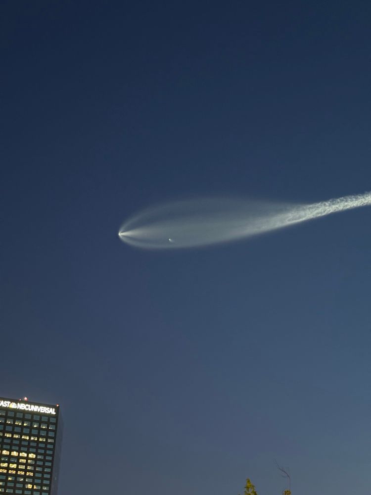
Some pics from tonight’s SpaceX launch out of Vandenberg SFB. @nbcla.com


June 17, 2025 at 3:46 AM
Some pics from tonight’s SpaceX launch out of Vandenberg SFB. @nbcla.com
It took some time, but we managed to get to clearing across most (but not all) Inland areas. Ventura County is still hanging onto the clouds right now.
Deeper marine layer today meant the clouds/fog pushed farther inland. Here's a clearing comparison between yesterday and today. @nbcla.com
Deeper marine layer today meant the clouds/fog pushed farther inland. Here's a clearing comparison between yesterday and today. @nbcla.com

April 30, 2025 at 10:44 PM
It took some time, but we managed to get to clearing across most (but not all) Inland areas. Ventura County is still hanging onto the clouds right now.
Deeper marine layer today meant the clouds/fog pushed farther inland. Here's a clearing comparison between yesterday and today. @nbcla.com
Deeper marine layer today meant the clouds/fog pushed farther inland. Here's a clearing comparison between yesterday and today. @nbcla.com
Felt that quake in the NoHo area. Got the alert and took cover, took some time for the shaking to arrive.
April 14, 2025 at 5:16 PM
Felt that quake in the NoHo area. Got the alert and took cover, took some time for the shaking to arrive.
California Snowpack Update ❄️
Apr 1 is considered to be the "peak" of the state's snowpack, which acts as a water bank account through the next several months. As snow melts, the runoff is captured by a network of reservoirs.
This year we are at 96% of average, still considered a healthy snowpack.
Apr 1 is considered to be the "peak" of the state's snowpack, which acts as a water bank account through the next several months. As snow melts, the runoff is captured by a network of reservoirs.
This year we are at 96% of average, still considered a healthy snowpack.


April 1, 2025 at 11:08 PM
California Snowpack Update ❄️
Apr 1 is considered to be the "peak" of the state's snowpack, which acts as a water bank account through the next several months. As snow melts, the runoff is captured by a network of reservoirs.
This year we are at 96% of average, still considered a healthy snowpack.
Apr 1 is considered to be the "peak" of the state's snowpack, which acts as a water bank account through the next several months. As snow melts, the runoff is captured by a network of reservoirs.
This year we are at 96% of average, still considered a healthy snowpack.
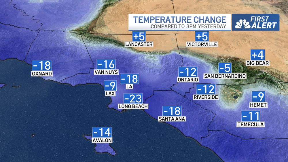
What a difference 1 day makes...
We are much cooler across the region today compared to yesterday at this time. Cooling continues into the weekend, along with drizzle and light rain chances.
Next week looks cool as well. @nbcla.com #LosAngeles #CAwx #SouthernCalifornia
We are much cooler across the region today compared to yesterday at this time. Cooling continues into the weekend, along with drizzle and light rain chances.
Next week looks cool as well. @nbcla.com #LosAngeles #CAwx #SouthernCalifornia

February 28, 2025 at 11:11 PM
What a difference 1 day makes...
We are much cooler across the region today compared to yesterday at this time. Cooling continues into the weekend, along with drizzle and light rain chances.
Next week looks cool as well. @nbcla.com #LosAngeles #CAwx #SouthernCalifornia
We are much cooler across the region today compared to yesterday at this time. Cooling continues into the weekend, along with drizzle and light rain chances.
Next week looks cool as well. @nbcla.com #LosAngeles #CAwx #SouthernCalifornia
Santa Ana Winds helped to push coastal temperatures up today...while inland areas stayed level or cooled a few degrees compared to yesterday.
Everyone will get much cooler tomorrow as the pattern starts to shift back to more of what we would see during winter.
Everyone will get much cooler tomorrow as the pattern starts to shift back to more of what we would see during winter.


February 27, 2025 at 11:07 PM
Santa Ana Winds helped to push coastal temperatures up today...while inland areas stayed level or cooled a few degrees compared to yesterday.
Everyone will get much cooler tomorrow as the pattern starts to shift back to more of what we would see during winter.
Everyone will get much cooler tomorrow as the pattern starts to shift back to more of what we would see during winter.
Reposted by David Biggar

The National Hurricane Center’s track forecasts for the 2024 season featured record accuracy, and intensity forecasts were at near-record accuracy, per a report released this week. The NHC is part of the National Weather Service, which is part of NOAA.
Full report: www.nhc.noaa.gov/pdf/NHC_Veri...
Full report: www.nhc.noaa.gov/pdf/NHC_Veri...

February 27, 2025 at 12:23 AM
The National Hurricane Center’s track forecasts for the 2024 season featured record accuracy, and intensity forecasts were at near-record accuracy, per a report released this week. The NHC is part of the National Weather Service, which is part of NOAA.
Full report: www.nhc.noaa.gov/pdf/NHC_Veri...
Full report: www.nhc.noaa.gov/pdf/NHC_Veri...


February 18, 2025 at 1:57 AM
We have multiple Flash Flood Warnings and a Severe Thunderstorm Warning. Details on @nbcla.com

February 14, 2025 at 12:22 AM
We have multiple Flash Flood Warnings and a Severe Thunderstorm Warning. Details on @nbcla.com
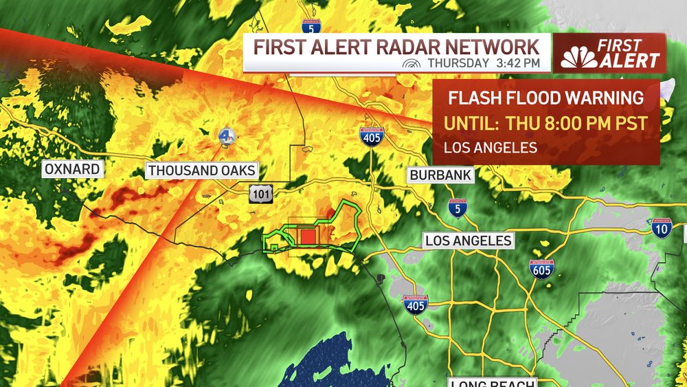
FLASH FLOOD WARNING - FRANKLIN AND PALISADES FIRE BURN SCARS UNTIL 8PM.
Life threatening debris flows are imminent or occurring.
Life threatening debris flows are imminent or occurring.
February 13, 2025 at 11:44 PM
FLASH FLOOD WARNING - FRANKLIN AND PALISADES FIRE BURN SCARS UNTIL 8PM.
Life threatening debris flows are imminent or occurring.
Life threatening debris flows are imminent or occurring.
The next round of heavier rainfall is about to move into LA County. This is the cold front sweeping across the region from west to east.
This will likely bring the heaviest rainfall of the day, and our concern for possible flooding problems as well as mudslides/debris flows near the burn scars.
This will likely bring the heaviest rainfall of the day, and our concern for possible flooding problems as well as mudslides/debris flows near the burn scars.

February 13, 2025 at 11:34 PM
The next round of heavier rainfall is about to move into LA County. This is the cold front sweeping across the region from west to east.
This will likely bring the heaviest rainfall of the day, and our concern for possible flooding problems as well as mudslides/debris flows near the burn scars.
This will likely bring the heaviest rainfall of the day, and our concern for possible flooding problems as well as mudslides/debris flows near the burn scars.
Reposted by David Biggar

National Weatherpersons Day, celebrated annually on February 5th, honors the professionals who work tirelessly to provide accurate weather forecasts and warnings, ensuring public safety and preparedness in the face of weather-related hazards.

February 5, 2025 at 5:10 PM
National Weatherpersons Day, celebrated annually on February 5th, honors the professionals who work tirelessly to provide accurate weather forecasts and warnings, ensuring public safety and preparedness in the face of weather-related hazards.

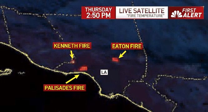
GOES "Fire Temperature" showing more activity with #EatonFire & #PalisadesFire compared to last night...you can also see the new #KennethFire pop onto the map. @nbcla.bsky.social
January 9, 2025 at 11:40 PM
GOES "Fire Temperature" showing more activity with #EatonFire & #PalisadesFire compared to last night...you can also see the new #KennethFire pop onto the map. @nbcla.bsky.social
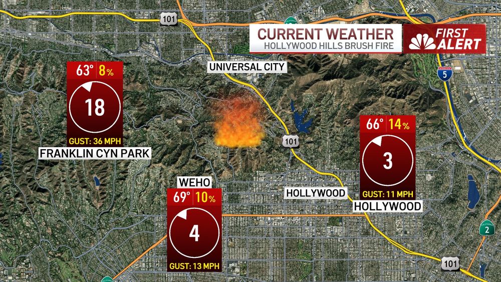
Conditions near a new fire in the Hollywood Hills, west of the Hollywood Bowl and Cahuenga Pass. @nbcla.bsky.social
January 9, 2025 at 1:49 AM
Conditions near a new fire in the Hollywood Hills, west of the Hollywood Bowl and Cahuenga Pass. @nbcla.bsky.social

January 8, 2025 at 3:07 AM
Current conditions near the #PalisadesFire, gusts are pushing the fire along fast, leading to long range spotting.
Stay out of the area and listen to all official evacuation orders. Have your go bag ready!
If you see fire approaching or don't feel safe, LEAVE!
@nbcla.bsky.social
Stay out of the area and listen to all official evacuation orders. Have your go bag ready!
If you see fire approaching or don't feel safe, LEAVE!
@nbcla.bsky.social

January 7, 2025 at 10:36 PM
Current conditions near the #PalisadesFire, gusts are pushing the fire along fast, leading to long range spotting.
Stay out of the area and listen to all official evacuation orders. Have your go bag ready!
If you see fire approaching or don't feel safe, LEAVE!
@nbcla.bsky.social
Stay out of the area and listen to all official evacuation orders. Have your go bag ready!
If you see fire approaching or don't feel safe, LEAVE!
@nbcla.bsky.social
The #PalisadesFire is moving rapidly with the strong winds. There is possibility for long range spotting.
If you feel unsafe, leave! Do not wait to be told to evacuate.
Do not try to defend your property with a garden hose, it won’t do anything in a situation like this. @nbcla.bsky.social
If you feel unsafe, leave! Do not wait to be told to evacuate.
Do not try to defend your property with a garden hose, it won’t do anything in a situation like this. @nbcla.bsky.social
January 7, 2025 at 7:28 PM
The #PalisadesFire is moving rapidly with the strong winds. There is possibility for long range spotting.
If you feel unsafe, leave! Do not wait to be told to evacuate.
Do not try to defend your property with a garden hose, it won’t do anything in a situation like this. @nbcla.bsky.social
If you feel unsafe, leave! Do not wait to be told to evacuate.
Do not try to defend your property with a garden hose, it won’t do anything in a situation like this. @nbcla.bsky.social
I've also got a wind impacts explanation on my IG: www.instagram.com/reel/DEguVwg...
January 7, 2025 at 6:01 AM
I've also got a wind impacts explanation on my IG: www.instagram.com/reel/DEguVwg...
Tomorrow will see the start of a damaging Santa Ana wind across portions of Southern California...more in this thread... @nbcla.bsky.social
January 7, 2025 at 5:28 AM
Tomorrow will see the start of a damaging Santa Ana wind across portions of Southern California...more in this thread... @nbcla.bsky.social
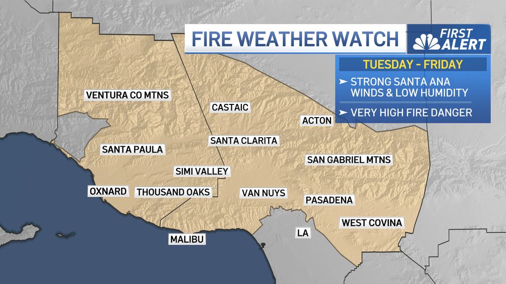
We are looking at the potential for moderate to strong Santa Ana Winds and very high fire danger for the middle of next week. Please monitor the forecast over the weekend for more details on the wind speeds and impacts.
A Fire Weather Watch has been issued for TUE-FRI. @NBCLA
A Fire Weather Watch has been issued for TUE-FRI. @NBCLA
January 3, 2025 at 10:46 PM
We are looking at the potential for moderate to strong Santa Ana Winds and very high fire danger for the middle of next week. Please monitor the forecast over the weekend for more details on the wind speeds and impacts.
A Fire Weather Watch has been issued for TUE-FRI. @NBCLA
A Fire Weather Watch has been issued for TUE-FRI. @NBCLA
Happy Festivus! Here's the forecast for this evening... @nbcla.bsky.social

December 23, 2024 at 11:09 PM
Happy Festivus! Here's the forecast for this evening... @nbcla.bsky.social
This image from Mt Wilson shows the haze trapped in the Basin thanks to a shallow inversion.
South Coast AQMD has issued a No-Burn Day for tomorrow since smoke would end up trapped in this layer. @nbcla.bsky.social
South Coast AQMD has issued a No-Burn Day for tomorrow since smoke would end up trapped in this layer. @nbcla.bsky.social


December 21, 2024 at 1:02 AM
This image from Mt Wilson shows the haze trapped in the Basin thanks to a shallow inversion.
South Coast AQMD has issued a No-Burn Day for tomorrow since smoke would end up trapped in this layer. @nbcla.bsky.social
South Coast AQMD has issued a No-Burn Day for tomorrow since smoke would end up trapped in this layer. @nbcla.bsky.social