David Roth
@drmetwatch.bsky.social
2.3K followers 1.5K following 940 posts
Meteorologist. Into weather records. Soft spot for subtropical 🌀. 😻 and nature imagery, too.
Posts Media Videos Starter Packs
Pinned
drmetwatch.bsky.social
Another week, another exposed category 2 hurricane. This time, it’s Priscilla.

Jerry isn’t ideal either. So long as Jerry remains this sheared, it can track more west, which would increase rain for the Leewards, Virgin Islands, & maybe Puerto Rico. Its future as a TC is more in doubt, too.
drmetwatch.bsky.social
Post-T.C. Imelda persists, much like the rest of us
drmetwatch.bsky.social
The video I took was at 15x on the 16pro, and you can see how that turned out with a squirrel significantly up a tall tree. I don’t doubt that the 17pro is great at 8-9x. I need the distance for the nature vids, so I chose 16pro.
drmetwatch.bsky.social
Post-T.C. Imelda continue to persist. Just like Ms. Marcos. ;)
Reposted by David Roth
wisconet.bsky.social
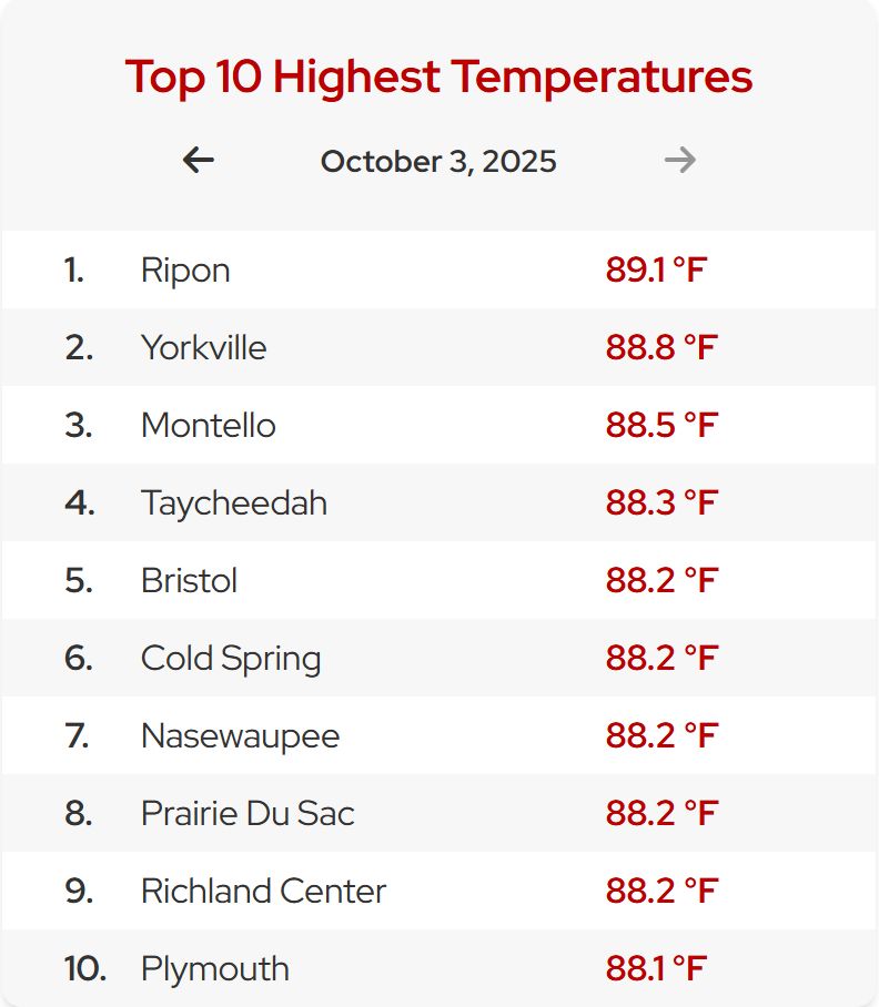
The 10 highest temperatures this afternoon across the state are all above 88°F...We event hit 88 in Door County!
10 highest temperatures in Wisconsin for October 3 range between 88 and 89.
drmetwatch.bsky.social
16 is clearly better than 14, thus far. The higher zoom-in vids look sharp, and it looks like the software continues to correct for any sharp movements/shaking.
drmetwatch.bsky.social
Yeah. The video/camera zoom-in specs are the same as the 14. At the store, they double checked. Not sure why. ¯\_(ツ)_/¯
drmetwatch.bsky.social
Upgraded from an iPhone 14 Pro Max to an iPhone 16 Pro Max recently. The zoom-in on the 17 was the same as the 14 (with the 16 having higher zoom-in) so it wasn’t worth it.

For a longer version of the squirrel video: #Squirrel with a #nut — early #October2025
youtu.be/nru7KdxIvwA
drmetwatch.bsky.social
Post-tropical cyclone Imelda presently
drmetwatch.bsky.social
Imelda, in its post-tropical/extratropical cyclone stage
Reposted by David Roth
drmetwatch.bsky.social
Imelda & Humberto, indecently exposed. Humberto to the east is a category two hurricane — our second exposed category 2 hurricane this season. 🔥
Reposted by David Roth
wildweatherdan.bsky.social
Got last nights sunset from the drone.
drmetwatch.bsky.social
Some dusk imagery.

A more complete slideshow is located here: Late #September2025 #dusk
youtu.be/EWhgpobqXL4
Reposted by David Roth
drmetwatch.bsky.social
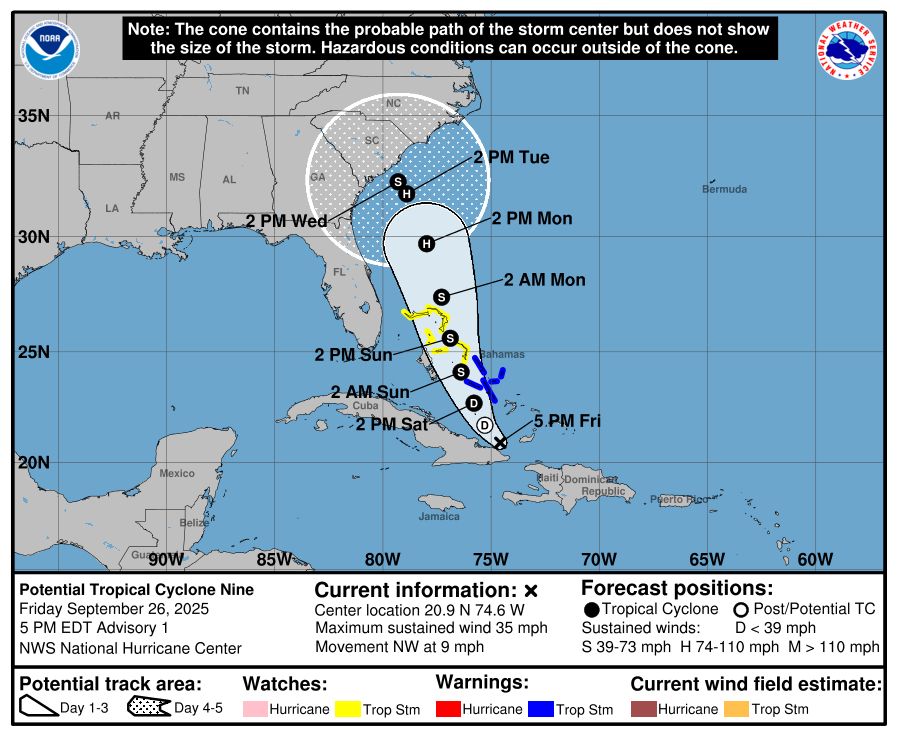
Imelda & Humberto. Without Imelda, Humberto would be more of a threat to the Southeast. Without Humberto, Imelda wouldn’t be expected to turn sharply out to sea and would be a greater rain threat to the Southeast. It might be more of a hybrid cyclone, too.
drmetwatch.bsky.social
The expectation is for, not it’s expect. :/
drmetwatch.bsky.social
Thank you, important upper level trough
drmetwatch.bsky.social
Not really. Landfalling solutions lack tropical characteristics since it crosses the upper level jet and crosses 1000-500 hPa thickness lines/isotherms on its way to the coast. ¯\_(ツ)_/¯
drmetwatch.bsky.social
Whether or not it makes landfall, heavy rain across the Carolinas and Virginia is expected over the next 3-5 days. The WPC forecast explicitly shows 7-10”, with locally higher amounts likely.
drmetwatch.bsky.social
NHC doesn’t make landfall within five days, which is the smart play. I’d expect some east-northeast shifts to the end of the forecast with time, as is the typical model/NHC track bias.
drmetwatch.bsky.social
So what’s the realistic expectation? Nine missing a US landfall and following Humberto out to sea, so long as it remains convectively coupled. Given the strength of the upper low to its west, it’s expect Joaquin 2015 over Sandy 2012, with 70% confidence.
drmetwatch.bsky.social
Matthew 2016 was the worst example of guidance making TCs too shallow & making unmeteorological forecasts. Remember Matthew’s turn into FL and the Yucatán after it moved offshore the Southeast?

Neither do I. Models all fcst’d that days 2-5, causing wild errors. Days 6-7 fcst into Nova Scotia? ✅
drmetwatch.bsky.social
This is why. Guidance that allows Nine to make landfall brings it as a shallow system, coupling/occluding it to the upper low near the Southern Appalachians.

Remember Sandy 2012 & Joaquin 2015 model problems? Anomalous prolonged stalling of Gustav & Ike 2008, Harvey 2017? This.
drmetwatch.bsky.social
NHC is calling for Nine to become a tropical cyclone. While its development had been very slow for many days, this appears to be a safe assumption. This is one piece of the model uncertainty issue/puzzle.