


Richard Heatwave Berler
@heatwavekgns.bsky.social
I love weather! CBS Duluth, MN May 23, 1976-80, KGNS Laredo, TX Feb 14, 1980-now. NCEI/NWS coop site 415060 June 10, 1985 to December 31, 2023. NWS Jefferson Award. AMS CBM#18
Wednesday 12:17 am: A bit breezy in Aberdeen, South Dakota, gusts >70 mph ~10 pm.


December 10, 2025 at 6:17 AM
Wednesday 12:17 am: A bit breezy in Aberdeen, South Dakota, gusts >70 mph ~10 pm.
Tuesday 4:10 pm: Big Picture Weathermap: Warm air is moving in from the west. We have been to at least 73F today. High thin cirrus will arrive in our skies tonight, milky white skies at times Wednesday morning to early afternoon. Upper 40's to ~50 dawn, ~80 Wednesday afternoon.

December 9, 2025 at 10:12 PM
Tuesday 4:10 pm: Big Picture Weathermap: Warm air is moving in from the west. We have been to at least 73F today. High thin cirrus will arrive in our skies tonight, milky white skies at times Wednesday morning to early afternoon. Upper 40's to ~50 dawn, ~80 Wednesday afternoon.
Tuesday 8:17 am: Warm Pacific air has crossed the Rockies into the Great Plains. We are on the south edge of the warmth as cool air over the gulf exits to the east. Increasing influence also from warm western Mexico. 38F at dawn at the airport, low/mid 70’s pm, bright sunshine.

December 9, 2025 at 2:19 PM
Tuesday 8:17 am: Warm Pacific air has crossed the Rockies into the Great Plains. We are on the south edge of the warmth as cool air over the gulf exits to the east. Increasing influence also from warm western Mexico. 38F at dawn at the airport, low/mid 70’s pm, bright sunshine.
Monday 4:21 pm: Big Picture Weathermap: The southern part of a cool airmass will bve close enough to our area for a chilly night, low 40's, colder on low lying ground. As the cool air exits to our east, low 70's Tuesday, 80F warmth Wednesday.

December 8, 2025 at 10:22 PM
Monday 4:21 pm: Big Picture Weathermap: The southern part of a cool airmass will bve close enough to our area for a chilly night, low 40's, colder on low lying ground. As the cool air exits to our east, low 70's Tuesday, 80F warmth Wednesday.
Monday 3:06 pm: Just Because Department: Cold in Arctic Canada/Alaska with some <-40F/C readings in interior Alaska/Yukon. Compare with Russia with large expanse of -40F/C, Kerbo at -62F/-52C


December 8, 2025 at 9:09 PM
Monday 3:06 pm: Just Because Department: Cold in Arctic Canada/Alaska with some <-40F/C readings in interior Alaska/Yukon. Compare with Russia with large expanse of -40F/C, Kerbo at -62F/-52C
Monday 8:56 am: A cool airmass will bring high 60’s with bright sunshine as much colder air passes far to our north. Warmer air moves in from the west, 70F Tuesday after low 40’s dawn, 80F warmth Wednesday.

December 8, 2025 at 2:58 PM
Monday 8:56 am: A cool airmass will bring high 60’s with bright sunshine as much colder air passes far to our north. Warmer air moves in from the west, 70F Tuesday after low 40’s dawn, 80F warmth Wednesday.
Sunday 4:16 pm: Big Picture Weathermap: The southern edge of a cold airmass centered over Minnesota will bring cooler high 60's Monday after a mid/high 40's dawn. North wind picks up ~ 7 or 8 pm, gusts ~25 mph.

December 7, 2025 at 10:17 PM
Sunday 4:16 pm: Big Picture Weathermap: The southern edge of a cold airmass centered over Minnesota will bring cooler high 60's Monday after a mid/high 40's dawn. North wind picks up ~ 7 or 8 pm, gusts ~25 mph.
The graph was for 7 am CST Sunday of temperature/dewpoint/wind vs altitude above Laredo. Not only was the lower atmosphere way too warm for snow reach the surface without melting, but the dgz (dendritic growth zone) was quite dry (No clouds in that layer)!

December 7, 2025 at 6:42 PM
The graph was for 7 am CST Sunday of temperature/dewpoint/wind vs altitude above Laredo. Not only was the lower atmosphere way too warm for snow reach the surface without melting, but the dgz (dendritic growth zone) was quite dry (No clouds in that layer)!
Sunday 8:44 am: Warm drier air is moving in from the west. Clearing skies, low 80’s this afternoon. Cooler dry air follows from the southern Great Plains as a cold airmass tracks by (missing us) further to the north, upper 60’s Monday.

December 7, 2025 at 2:58 PM
Sunday 8:44 am: Warm drier air is moving in from the west. Clearing skies, low 80’s this afternoon. Cooler dry air follows from the southern Great Plains as a cold airmass tracks by (missing us) further to the north, upper 60’s Monday.
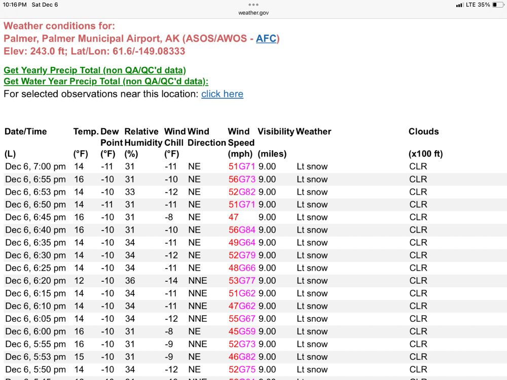
Palmer, a little east of Wasilla even with more wind. Not show is a brief gust to 94 mph at ~3:45 pm CST!
December 7, 2025 at 4:21 AM
Palmer, a little east of Wasilla even with more wind. Not show is a brief gust to 94 mph at ~3:45 pm CST!
Saturday 9:36 pm: By dawn, a razor thin layer of moist, saturated air may produce patches of fog. Warm dry air just above will stir in with daytime heating, becoming sunny with 80F afternoon warmth.

December 7, 2025 at 3:38 AM
Saturday 9:36 pm: By dawn, a razor thin layer of moist, saturated air may produce patches of fog. Warm dry air just above will stir in with daytime heating, becoming sunny with 80F afternoon warmth.

Saturday 3:53 pm: Just Because Department: Very tight pressure gradient (large change in air pressure over small distance) producing 60-70 mph gusts in Wasilla, a little northeast of Anchorage.

December 6, 2025 at 9:54 PM
Saturday 3:53 pm: Just Because Department: Very tight pressure gradient (large change in air pressure over small distance) producing 60-70 mph gusts in Wasilla, a little northeast of Anchorage.
Added a couple of boundaries to my analysis:

December 6, 2025 at 9:31 PM
Added a couple of boundaries to my analysis:
Saturday 2:53 pm: Warmer air is flowing in from the southwest with clearing and west, 70’s feat of afternoon, 80F warmth Sunday.

December 6, 2025 at 8:52 PM
Saturday 2:53 pm: Warmer air is flowing in from the southwest with clearing and west, 70’s feat of afternoon, 80F warmth Sunday.
Saturday 9:59 am: The cool airmass is moving away to our east, warmer drier air is moving in from the west. Mostly sunny, mid 70’s this afternoon.

December 6, 2025 at 4:00 PM
Saturday 9:59 am: The cool airmass is moving away to our east, warmer drier air is moving in from the west. Mostly sunny, mid 70’s this afternoon.
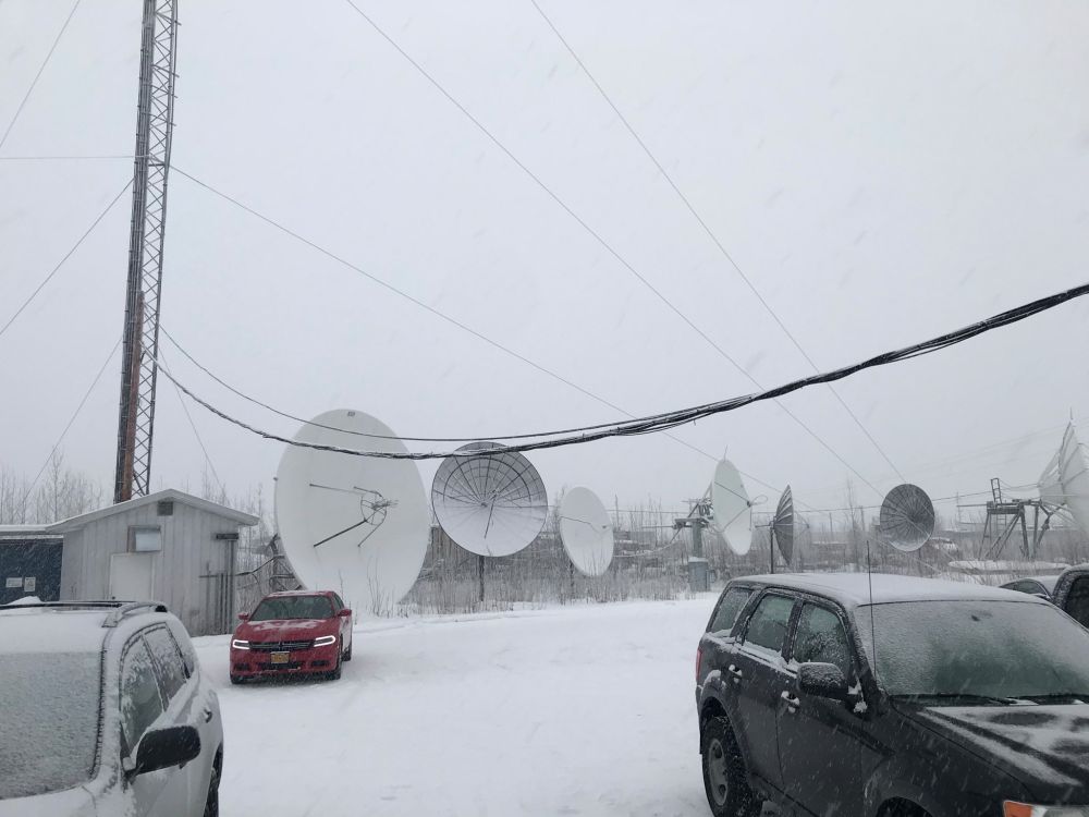
Angle of satellite dishes pointing to geosynchronous satellite in Fairbanks vs Laredo:

December 6, 2025 at 4:30 AM
Angle of satellite dishes pointing to geosynchronous satellite in Fairbanks vs Laredo:
Friday 10:18 pm: Still a few patches of showers, chance ends around dawn. Warmer drier air moves in from the southwest with clearing skies, will clear early enough to reach the 70’s Saturday, 80F warmth Sunday.


December 6, 2025 at 4:19 AM
Friday 10:18 pm: Still a few patches of showers, chance ends around dawn. Warmer drier air moves in from the southwest with clearing skies, will clear early enough to reach the 70’s Saturday, 80F warmth Sunday.
Friday 3:01 pm: Big Picture Weathermap: A cool airmass will begin to exit our area Saturday. Still a few sprinkles around, most of the time, simply cloudy through Saturday morning. Clearing Saturday afternoon with upper 60’s, low 70’s if it clears early.

December 5, 2025 at 9:02 PM
Friday 3:01 pm: Big Picture Weathermap: A cool airmass will begin to exit our area Saturday. Still a few sprinkles around, most of the time, simply cloudy through Saturday morning. Clearing Saturday afternoon with upper 60’s, low 70’s if it clears early.
Friday 2:28 pm: Fine and larger scale waves in mid/high level cloud flowing from WSW to ENE above Texas.

December 5, 2025 at 8:29 PM
Friday 2:28 pm: Fine and larger scale waves in mid/high level cloud flowing from WSW to ENE above Texas.
Friday 1:28 pm: A bit windy on Saint Pierre and Miquelon. Winds gusting >60 mph (>52 knots) for a number of hours, most recent observation with 59 knot/68 mph gust.


December 5, 2025 at 7:29 PM
Friday 1:28 pm: A bit windy on Saint Pierre and Miquelon. Winds gusting >60 mph (>52 knots) for a number of hours, most recent observation with 59 knot/68 mph gust.


Friday 8:18 am: A cool airmass remains as our weather control. Moist air flowing above our cool air is bringing cloudy skies and a few patches of sprinkles/light showers. Upper 50’s (low 60’s if we see breaks in clouds) late afternoon.


December 5, 2025 at 2:19 PM
Friday 8:18 am: A cool airmass remains as our weather control. Moist air flowing above our cool air is bringing cloudy skies and a few patches of sprinkles/light showers. Upper 50’s (low 60’s if we see breaks in clouds) late afternoon.
Thursday 9:57 pm: Just Because Department: During the winter season, cool airmasses can reach pretty far to the south, even beyond 20N latitude in North Africa. 850 mb map shows this well, very warm air to the south of the front.


December 5, 2025 at 3:58 AM
Thursday 9:57 pm: Just Because Department: During the winter season, cool airmasses can reach pretty far to the south, even beyond 20N latitude in North Africa. 850 mb map shows this well, very warm air to the south of the front.
Thursday 4:13 pm: Big Picture Weathermap: A cool airmass extends south through south Texas. Rising air ahead of a wave in the upper level wind flow may bring patches of light rain in a layer of moist air above our north wind tonight and Friday, high 40's dawn, upper 50's Friday.

December 4, 2025 at 10:24 PM
Thursday 4:13 pm: Big Picture Weathermap: A cool airmass extends south through south Texas. Rising air ahead of a wave in the upper level wind flow may bring patches of light rain in a layer of moist air above our north wind tonight and Friday, high 40's dawn, upper 50's Friday.