


Richard Heatwave Berler
@heatwavekgns.bsky.social
I love weather! CBS Duluth, MN May 23, 1976-80, KGNS Laredo, TX Feb 14, 1980-now. NCEI/NWS coop site 415060 June 10, 1985 to December 31, 2023. NWS Jefferson Award. AMS CBM#18
Sunday 4:26 pm: Big Picture Weathermap: A shallow layer of moist air remains over our area, will bring a return of low cloud late tonight. Drier air above will mix the cloud away midday/early afternoon Monday, high 70's to ~80.

December 21, 2025 at 10:27 PM
Sunday 4:26 pm: Big Picture Weathermap: A shallow layer of moist air remains over our area, will bring a return of low cloud late tonight. Drier air above will mix the cloud away midday/early afternoon Monday, high 70's to ~80.
Sunday 1:53 pm: High noon on the winter solstice in Laredo at solar noon (12:35:53 CST). Sun 39 degrees above the horizon. Compare summer solstice, sun 86 degrees above the horizon, my shadow is mostly under me:


December 21, 2025 at 7:55 PM
Sunday 1:53 pm: High noon on the winter solstice in Laredo at solar noon (12:35:53 CST). Sun 39 degrees above the horizon. Compare summer solstice, sun 86 degrees above the horizon, my shadow is mostly under me:
Sunday 1:41 pm: Front is north of us, low cloud mixed away, leaving us in sunshine with our 285th day 80F or higher this year. McAllen with 301st 80F+ day. Cotulla is under low cloud with 67F.

December 21, 2025 at 7:45 PM
Sunday 1:41 pm: Front is north of us, low cloud mixed away, leaving us in sunshine with our 285th day 80F or higher this year. McAllen with 301st 80F+ day. Cotulla is under low cloud with 67F.
Winter Solstice just happened at 9:03 am CST. A shallow layer of moist air may take too long to be mixed away by drier air above as front stalls nearby. Mostly cloudy, perhaps sunnier mid or late afternoon, how high above 70F depends on how much sun we get.

December 21, 2025 at 3:10 PM
Winter Solstice just happened at 9:03 am CST. A shallow layer of moist air may take too long to be mixed away by drier air above as front stalls nearby. Mostly cloudy, perhaps sunnier mid or late afternoon, how high above 70F depends on how much sun we get.
Saturday 11:29 pm: Pretty good, consistent handling of the main North American weather systems for Santa’s ride to Laredo 6,5, now 4 days out:


December 21, 2025 at 5:29 AM
Saturday 11:29 pm: Pretty good, consistent handling of the main North American weather systems for Santa’s ride to Laredo 6,5, now 4 days out:
Saturday 11:09 pm: 4 days out, still looking like a warm arrival for Santa!
December 21, 2025 at 5:10 AM
Saturday 11:09 pm: 4 days out, still looking like a warm arrival for Santa!
Saturday 6:21 pm: Rio Grande Village along the Rio Grande in southeastmost part of Big Bend raised the U.S. record for days at or above 90F in a year to 242. McAllen reached 90F for their 227th time. Laredo stayed at 224 days (a Laredo recor) with a high of 85F. Rio Grade Village from today:

December 21, 2025 at 3:56 AM
Saturday 6:21 pm: Rio Grande Village along the Rio Grande in southeastmost part of Big Bend raised the U.S. record for days at or above 90F in a year to 242. McAllen reached 90F for their 227th time. Laredo stayed at 224 days (a Laredo recor) with a high of 85F. Rio Grade Village from today:
December 21, 2025 at 12:24 AM
Saturday 6:21 pm: Rio Grande Village along the Rio Grande in southeastmost part of Big Bend raised the U.S. record for days at or above 90F in a year to 242. McAllen reached 90F for their 227th time. Laredo stayed at 224 days (a Laredo recor) with a high of 85F. Rio Grade Village from today:
Fantastic article on the possibility of 500-1,000 megaton bombs. This must have prompted Teller’s comment on delivery system for this sort of device: backyard thebulletin.org/2021/11/the-...

The untold story of the world’s biggest nuclear bomb
The secret history of the world’s largest nuclear detonation is coming to light after 60 years. The United States dismissed the gigantic Tsar Bomba as a stunt, but behind the scenes was working to bui...
thebulletin.org
December 21, 2025 at 12:09 AM
Fantastic article on the possibility of 500-1,000 megaton bombs. This must have prompted Teller’s comment on delivery system for this sort of device: backyard thebulletin.org/2021/11/the-...
Added weak warm front Alabama to Texas/Oklahoma border.

December 20, 2025 at 9:08 PM
Added weak warm front Alabama to Texas/Oklahoma border.
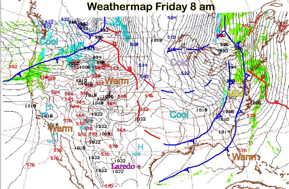
Saturday 3:04 pm: Big Picture Weathermap: The southern edge of a cool airmass over the central Great Plains may shift our wind into the north Sunday pm. Low cloud/possible fog early Sunday, partly cloudy, high 70’s to near 80F in the afternoon.

December 20, 2025 at 9:05 PM
Saturday 3:04 pm: Big Picture Weathermap: The southern edge of a cool airmass over the central Great Plains may shift our wind into the north Sunday pm. Low cloud/possible fog early Sunday, partly cloudy, high 70’s to near 80F in the afternoon.
Saturday 2:16 pm: Just wrote to both of my Texas U.S. Senators…this is important, shine the light on NCAR’s importance!
Important to reach out to your congressman on this. I was brief in my remarks, Dr Shepherd‘s article linked in my reach out:
December 20, 2025 at 8:17 PM
Saturday 2:16 pm: Just wrote to both of my Texas U.S. Senators…this is important, shine the light on NCAR’s importance!
I contacted my congressman, now onto the senate!

From @AGU.org: Senators are working on legislation to save NCAR, but we need extra support for these 8 states. Your Senators in Alabama, Alaska, Florida, Louisiana, Mississippi, North Carolina, Texas, and Wyoming need to hear from you.
December 20, 2025 at 7:22 PM
I contacted my congressman, now onto the senate!
Saturday 10:06 am: Dry air just above our shallow layer of moist gulf air is stirring in, mixing away the low cloud/fog. A sunny warm afternoon, high into the 80’s.

December 20, 2025 at 4:06 PM
Saturday 10:06 am: Dry air just above our shallow layer of moist gulf air is stirring in, mixing away the low cloud/fog. A sunny warm afternoon, high into the 80’s.
Friday 10:58 pm: One day closer, now a 6 day out forecast model for Santa’s route to Laredo!
December 20, 2025 at 5:00 AM
Friday 10:58 pm: One day closer, now a 6 day out forecast model for Santa’s route to Laredo!
Friday from the American Meteorological Society concerning the government announcement of the closing of the National Center for Atmospheric Research (NCAR):

December 19, 2025 at 9:37 PM
Friday from the American Meteorological Society concerning the government announcement of the closing of the National Center for Atmospheric Research (NCAR):
Friday 3:04 pm: Big Picture Weathermap: A mild Rocky Mountain airmass is exiting to our east. Very warm air is expanding north and east from northern Mexico. After possible patches of fog at dawn, low/mid 50’s, high 80’s, sunny Saturday afternoon.

December 19, 2025 at 9:06 PM
Friday 3:04 pm: Big Picture Weathermap: A mild Rocky Mountain airmass is exiting to our east. Very warm air is expanding north and east from northern Mexico. After possible patches of fog at dawn, low/mid 50’s, high 80’s, sunny Saturday afternoon.
More excellent perspective on the importance and real world impact of NCAR in many disciplines, informed human endeavors and understanding.

"Attempting to erase a country’s scientific heritage, as the Trump administration is now trying to do, should be of concern to every US citizen. Because if climate science is viewed with disfavor today, other fields of scientific inquiry might be next in line for the chopping block."—Ben Santer.

Threatening NCAR, Trump administration seeks to extinguish a beacon of climate science
The Trump administration’s world view is that the US doesn’t need a climate science brain trust because it doesn’t like what the brains say.
thebulletin.org
December 19, 2025 at 6:27 PM
More excellent perspective on the importance and real world impact of NCAR in many disciplines, informed human endeavors and understanding.
Important to reach out to your congressman on this. I was brief in my remarks, Dr Shepherd‘s article linked in my reach out:
December 19, 2025 at 6:02 PM
Important to reach out to your congressman on this. I was brief in my remarks, Dr Shepherd‘s article linked in my reach out:


December 19, 2025 at 5:50 PM
Important to reach out to your congressman on this. I was brief in my remarks, Dr Shepherd‘s article linked in my reach out:
Friday 8:30 am: Dry mild/warm afternoon with low humidity. Cannot rule out patches of fog dawn Saturday and Sunday, but increasingly warm as warmth expands east and northeast from northern Mexico. Mid/high 80’s Saturday pm, low/mid 80’s Sunday pm.
December 19, 2025 at 2:32 PM
Friday 8:30 am: Dry mild/warm afternoon with low humidity. Cannot rule out patches of fog dawn Saturday and Sunday, but increasingly warm as warmth expands east and northeast from northern Mexico. Mid/high 80’s Saturday pm, low/mid 80’s Sunday pm.
Friday 12:40 am: An early look at the weather that Santa will experience as he travels to Laredo:
December 19, 2025 at 6:41 AM
Friday 12:40 am: An early look at the weather that Santa will experience as he travels to Laredo:
Friday 12:04 am: Great detail in this summary of the breadth of what NCAR does. Way too important to our nation to be caught up in politics:


December 19, 2025 at 6:04 AM
Friday 12:04 am: Great detail in this summary of the breadth of what NCAR does. Way too important to our nation to be caught up in politics:
Not going down, not down for the count…

"A Democratic senator involved in the negotiations...said that Trump’s attempt to break up a premier weather and climate center based in Boulder, Colo., was like a “stick of dynamite” that exploded any chance of a bipartisan breakthrough on spending."
thehill.com/homenews/sen...
thehill.com/homenews/sen...

Trump move to dismantle climate agency blows up Senate funding deal
A potential deal to fund large swaths of the federal government, including the Departments of Defense and Health and Human Services, collapsed on Thursday night after Colorado senators demanded tha…
thehill.com
December 19, 2025 at 5:25 AM
Not going down, not down for the count…
Thursday 9:21 pm: A brief appearance of desert air today, reached 89F, equaling record set at Laredo Airport in 2012. Our 283rd 80F+ day, McAllen with their 299th day. 70’s in Rocky Mountain air Friday, then an extended period of mostly 80F+ days to beyond Christmas Day.


December 19, 2025 at 3:23 AM
Thursday 9:21 pm: A brief appearance of desert air today, reached 89F, equaling record set at Laredo Airport in 2012. Our 283rd 80F+ day, McAllen with their 299th day. 70’s in Rocky Mountain air Friday, then an extended period of mostly 80F+ days to beyond Christmas Day.