


James Aydelott
@jamesaydelott.bsky.social
He/Him/His
-😍Daddy to 2
-4th Gen Okie
-BS OU Meteorology -MS OkState Emergency Mngmnt
-PhD student OkState Emergency Mngmnt
-Pilot
-Raconteur
-Antagonist
‘Gram: @jamesaydelottwx
Threads: @jamesaydelottwx
-😍Daddy to 2
-4th Gen Okie
-BS OU Meteorology -MS OkState Emergency Mngmnt
-PhD student OkState Emergency Mngmnt
-Pilot
-Raconteur
-Antagonist
‘Gram: @jamesaydelottwx
Threads: @jamesaydelottwx
743am—Radar update
Light wintry mix continues to push east. We will still see chances of light sleet, rain or snowflakes into the afternoon, but road conditions will slowly improve through 10am. #okwx
Light wintry mix continues to push east. We will still see chances of light sleet, rain or snowflakes into the afternoon, but road conditions will slowly improve through 10am. #okwx
December 1, 2025 at 1:46 PM
743am—Radar update
Light wintry mix continues to push east. We will still see chances of light sleet, rain or snowflakes into the afternoon, but road conditions will slowly improve through 10am. #okwx
Light wintry mix continues to push east. We will still see chances of light sleet, rain or snowflakes into the afternoon, but road conditions will slowly improve through 10am. #okwx
629am—Radar update
wintry mix of light sleet and freezing rain continues across Eastern Oklahoma. Be alert for icy spots, especially untreated bridges and overpasses. #okwx
wintry mix of light sleet and freezing rain continues across Eastern Oklahoma. Be alert for icy spots, especially untreated bridges and overpasses. #okwx
December 1, 2025 at 12:31 PM
629am—Radar update
wintry mix of light sleet and freezing rain continues across Eastern Oklahoma. Be alert for icy spots, especially untreated bridges and overpasses. #okwx
wintry mix of light sleet and freezing rain continues across Eastern Oklahoma. Be alert for icy spots, especially untreated bridges and overpasses. #okwx
November 20, 2025 at 5:27 AM
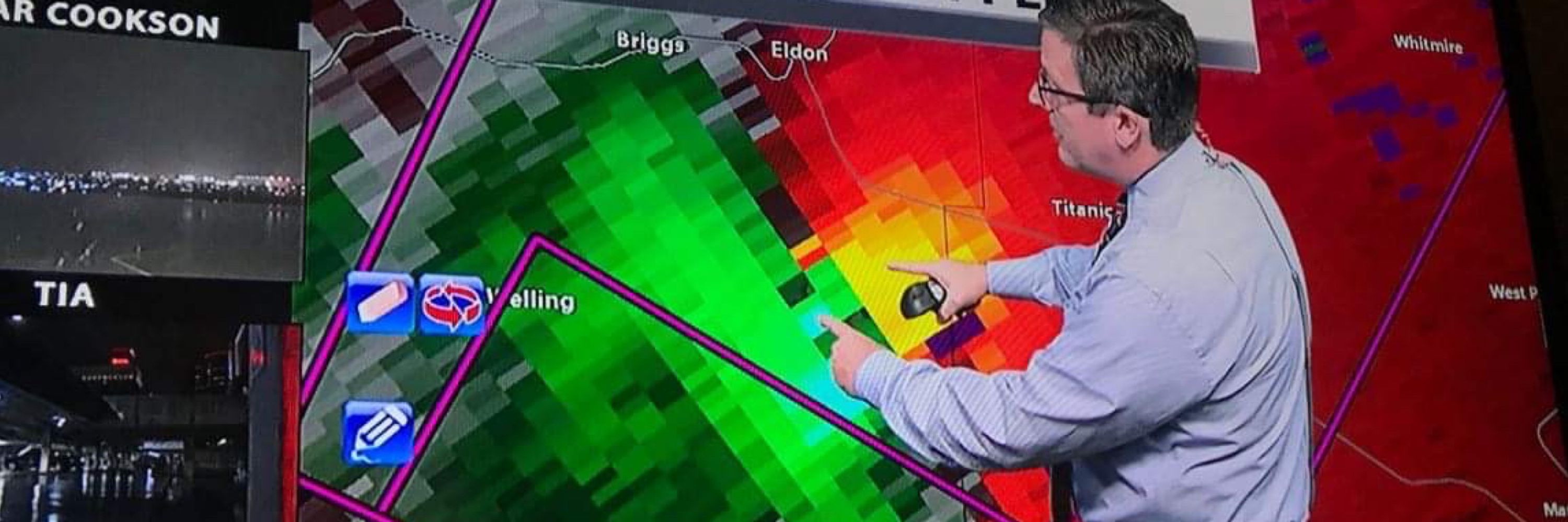
1045pm-Radar update
Severe Storm in SE Washington County, moving NE toward Nowata. Slow weakening trend noted, but still capable of quarter sized hail. No rotation. #okwx
Severe Storm in SE Washington County, moving NE toward Nowata. Slow weakening trend noted, but still capable of quarter sized hail. No rotation. #okwx
November 20, 2025 at 4:46 AM
1045pm-Radar update
Severe Storm in SE Washington County, moving NE toward Nowata. Slow weakening trend noted, but still capable of quarter sized hail. No rotation. #okwx
Severe Storm in SE Washington County, moving NE toward Nowata. Slow weakening trend noted, but still capable of quarter sized hail. No rotation. #okwx
936pm-Radar update
Severe storm moving over Mannford now. Hail up to half-dollar size possible. Post pics of the hail in replies if you can. #okwx
Severe storm moving over Mannford now. Hail up to half-dollar size possible. Post pics of the hail in replies if you can. #okwx
November 20, 2025 at 3:38 AM
936pm-Radar update
Severe storm moving over Mannford now. Hail up to half-dollar size possible. Post pics of the hail in replies if you can. #okwx
Severe storm moving over Mannford now. Hail up to half-dollar size possible. Post pics of the hail in replies if you can. #okwx