LCC municipal
@lccmunicipal.bsky.social
3.3K followers 2.5K following 750 posts
London County Council, Greater London Council, pre- and post-1965 boroughs in London (+ occasional forays outside of the capital). Municipal stuff from the past that lives on today. Oh, and new towns, shopping centres, infrastructure etc. lccmunicipal.com
Posts Media Videos Starter Packs
lccmunicipal.bsky.social
Some pre-1965 Municipal Borough of Beddington & Wallington sign action for you: a Surrey Borough replaced in 1965 by the London Borough of Sutton.
A rectangular metal sign with the text “Borough of Beddington and Wallington” embossed in black on a white background.  The sign also includes the former Borough’s coat of arms.
Reposted by LCC municipal
mikeyashworth.bsky.social
A fine pre-1974 County boundary sign for the old East Riding of Yorkshire County Council - seen in Hull’s wonderful Streetlife Museum. @lccmunicipal.bsky.social @showmeasign.online #yorkshire #hull
An old cast metal boundary sign for the pre-1974 East Riding of Yorkshire seen in Hull’s great Streetlife Museum. White with black cast lettering and to the left the old County coat of arms
lccmunicipal.bsky.social
Camden workers against rate capping. A 1980s protest badge against the Thatcher government’s restrictions on local government revenue raising and expenditure:
A round badge. It has a white background with the words “Camden Workers” in red. The word “against” is written below in a mock-graffiti style (black and white). Finally, the words “Rate Capping” are written in red.
lccmunicipal.bsky.social
Municipal guide cover of the day: Halesowen (1969) with a perfect 60’s sketch of the shopping centre. The guide was published by Burrows.
The cover contains a black and white sketch of a 1960s shopping precinct with a brick-encircled flower bed in the middle distance and some “1960s architecture” shops in the background. Superimposed on this are three wedges of colour - blue at the top, tan in the middle and brown at the bottom.  The title is Halesowen Official guide.
lccmunicipal.bsky.social
Let’s not forget that the former Metropolitan Borough of Wandsworth found some of its eastern flank (mainly Streatham) taken into the new LB Lambeth in 1965!
Reposted by LCC municipal
jolloyds.bsky.social
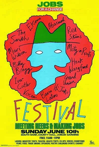
This very GLC Festival appears in the story Adrian Duncan & I wrote for @scratchbooks.bsky.social's "Duets" collection - lovely to see the posters here from @michael954.bsky.social and @lccmunicipal.bsky.social :
A paragraph "The Girl Chewing Gum" in "Duets":
In the summer of 1984, not long after they met, Jackie went with Rosa to one of the GLC’s free festivals on the South Bank. The Smiths were playing, Billy Bragg, Black Uhuru. Every single person there was in agreement about everything: reclaiming the night and freeing Nelson Mandela and ending Cruise missiles. It was like visiting the future, where everyone would know what was good and how to achieve it, and the music would be glorious.
Reposted by LCC municipal
michael954.bsky.social
This was the poster for the second Jobs For A Change festival - here is the poster for the first one.
lccmunicipal.bsky.social
GLC “jobs for a change” festival poster for the event held at Battersea Park:
The poster is purple with the word Festival in yellow. The F of Festival is enlarged and the following is written over it:
JOBS FOR A CHANGE
MUSIC
THE JOBS MAZE
CABARET
EXHIBITIONS
THEATRE
STALLS
KIDS AREA
VIDEOS
GAMES
CO-OPS
TRADE UNIONS
GLC JOBS
YEAR '85
in conjunction with
Batterses and Wandsworth Trades Union Council
SUNDAY JULY 7th| BATTERSEA PARK
lccmunicipal.bsky.social
GLC flood risk materials were plentiful in the 1970s given the Authority’s responsibilities in this regard. However, the volume of public facing communications reduced somewhat when the Thames Barrier - that great GLC project - became operational in the 1980s. Two examples here:
London Flooding Would YOU be affected?
Flood Risk
In certain weather conditions between August and April a high tide could cause flooding in London. The area at risk is shown on the map.
Public Warnings
Radio and TV will broadcast EARLY WARNING about 4 hours before flooding seems
likely.
If the risk continues, a SIREN WARNING will sound in the risk area
(six 30 second blasts at 15 second intervals) about 1 hour before expected flooding.
Public Transport
Bus, Underground and BR Services through the risk area will be reduced about 2 hours after Early Warning and will cease after the sirens sound.
What YOU should do
At the early warning
If you work in the risk area, or have to travel through it set off for home as soon as you can.
If you live in the area stay tuned to the radio, listen for the sirens and be ready to follow advice given by your local council.
At the siren warning
Stay tuned to the radio and follow local advice. Do not attempt to travel.
After any warning, stay tuned to the radio A map of Inner London showing flood risk areas. An arrow is pointing at the map with the following text: This map shows the risk area. If you are an employer in or around this area, read the advice overleaf.

Also included as a mocked up view of traffic under flood water at Lambeth Bridge - an image much used in GLC flood communications and in materials promoting the Thames Barrier.
lccmunicipal.bsky.social
Municipal guide cover(s) of the day: brutalist public buildings special edition. Featuring Preston Guild Hall and Slough’s Fulcrum Centre.
Two guides. On the left is a Borough of Preston official guide featuring a colour photo of the Guild Hall by RMJM which opened in 1973. On the right is a Borough of Slough official guide - on the cover is a black and white sketch of the Fulcrum Centre.
lccmunicipal.bsky.social
I love this one and have always been a fan of those funky tiled columns below. In return, I offer you this example at Fisherton Street!
An early 20th Century block of flats built by St Marylebone Metropolitan Borough. It features a large tiled version of the former Borough’s coat of arms on the side.
Reposted by LCC municipal
blitzwalker.bsky.social
@lccmunicipal.bsky.social One for you, just off Praed Street, a fine Metropolitan Borough of St. Marylebone crest inset into the wall of an apartment block currently undergoing renovation work.
Metropolitan Borough of St. Marylebone crest on the side of a building in Transept Street/Praed Street, London NW1.
Reposted by LCC municipal
mikeyashworth.bsky.social
Central Bradford and Church Bank in 1966 with the HQ of the once mighty Bradford Dyers Association amidst a changing landscape that's changed again. Lots of street lighting & road sign action. @showmeasign.online @sabre-roads.org.uk @lccmunicipal.bsky.social @roads.org.uk

(found photo: likey T&A)
Central Bradford in 1966 with the HQ of the once mighty Bradford Dyers Association amidst a changing landscape. Lots of street lighting & road sign action. The view is looking across a section of roundabout towards Church Bank with a large blackened stone building on the right showing lettering "Bradford Dyers Association". On the roundabout are a number of vehicles, all UK made, headed up by a Mini van.
lccmunicipal.bsky.social
Which reminds me of this badge that I picked up at the Ideal Home Exhibition a long time ago…
A black badge which is square, but rotated to a diamond shape. The wording, in white, says IT'S SMART TO BE SQUARE BSB
lccmunicipal.bsky.social
I had never noticed this before, but Cheam station still boasts an original BSB “squarial”. I felt the need to share this important discovery.
A photo of a square satellite dish produced for British Satellite Broadcasting c.1989/90. It is affixed to a wooden pole.
lccmunicipal.bsky.social
As the Kingsbury boundary continued the line of the southern bit of the incursion, it looks less pronounced. What is probably more unusual is having such a straight Roman road form a boundary for so long - rarely are Borough boundaries so orderly. So perhaps that is the anomaly!
lccmunicipal.bsky.social
I don’t know, although it probably relates to old parishes. On this 1928 map Kingsbury UDC (moved into Wembley in 1934) and Willesden UDC (not a borough until 1933) clearly have the A5 as their boundary. The former Hendon UDC crosses the A5 and its legacy is that very same incursion.
lccmunicipal.bsky.social
Municipal guide cover of the day: no nonsense from the London Borough of Brent, c.1969
The cover is brownish/olive green in colour and has the title “London Borough of Brent” on the top half. On the bottom half is a blue outline box containing a map of the Borough in a bold and contrasting yellow. On the map are marked major roads and civic buildings.
lccmunicipal.bsky.social
That would be a wonderful thing to do, but tracking down the copyright holders and getting the permissions has always felt like a bit of an obstacle. But there might be a way?
lccmunicipal.bsky.social
The artist is William Whatley (I have struggled deciphering the signature on previous artworks of his as it reads as IV Hatley, but the guide gives a specific printed credit inside). He also produced this lively Hillingdon cover and this rather more tame effort for Harrow:
lccmunicipal.bsky.social
Municipal guide cover of the day (possibly an all time great!): Croydon, 1971. Countdown typeface klaxon!
The cover is a watercolour painting of Croydon Town Centre looking across from Duppas Hill with the flyover in the foreground. The title says “Croydon Guide” in the futuristic Countdown typeface.
lccmunicipal.bsky.social
Junction 10 of the M1 has the plaque that was unveiled at the motorway’s inauguration in 1958. It was relocated in the late noughties when the junction was rebuilt and the first photo is from Google Street View in 2010 - the second is more recent. I’m surprised it hasn’t been better cared for…
A plaque at junction 10 of the M1 it is standing among newly laid turf with some new tree planting behind. The view is from 2010 This view from 2021, 11 years later, shows the area to be completely overgrown and the plaque barely visible