


Meghan Gulledge
@meggulledgewx.bsky.social
Meteorologist | Mississippi State '22 | WxComm | BoyMom | Lover of condensation ☁️, convection 🌩, coffee ☕️, and cats 🐈
I sometimes write about weather here: https://meteorologicalmeg.substack.com/
I sometimes write about weather here: https://meteorologicalmeg.substack.com/
Pinned

Quick intro for a new platform:
MSU BOMP grad '22. Former writer WeatherUs/Weathermodels.
Current "freelancer" while my main focus is being the mom my young son needs at this stage.
Passionate about forecast/impact communication and wx education.
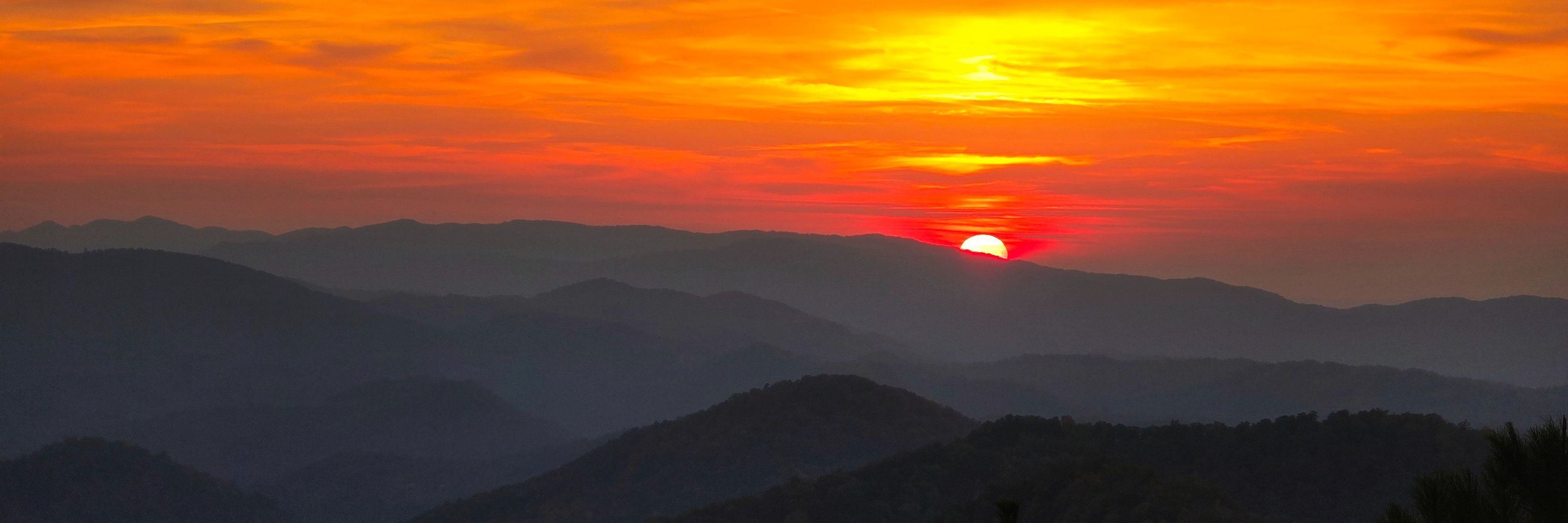
Please enjoy a photo from where I call home:
MSU BOMP grad '22. Former writer WeatherUs/Weathermodels.
Current "freelancer" while my main focus is being the mom my young son needs at this stage.
Passionate about forecast/impact communication and wx education.
Please enjoy a photo from where I call home:
Reposted by Meghan Gulledge

🔥Let's check in and see how much December temperatures have changed (trend) over the last 75 years. 🔥

December 1, 2025 at 8:17 PM
🔥Let's check in and see how much December temperatures have changed (trend) over the last 75 years. 🔥
Reposted by Meghan Gulledge

Hurricane Melissa produced the fastest hurricane winds to be recorded by a dropsonde, verified by reviewing data at NSF NCAR! Hurricane Melissa’s 252 mph wind gust surpassed the previous record from Typhoon Megi over the Western Pacific in 2010, where a dropsonde measured wind gusts of 248 mph.

November 19, 2025 at 5:37 PM
Hurricane Melissa produced the fastest hurricane winds to be recorded by a dropsonde, verified by reviewing data at NSF NCAR! Hurricane Melissa’s 252 mph wind gust surpassed the previous record from Typhoon Megi over the Western Pacific in 2010, where a dropsonde measured wind gusts of 248 mph.
Reposted by Meghan Gulledge

NEW: Epstein survivors release the most powerful PSA I have ever seen.
Make this go viral so every member of the House of Representatives sees it.
Make this go viral so every member of the House of Representatives sees it.
November 16, 2025 at 11:43 PM
NEW: Epstein survivors release the most powerful PSA I have ever seen.
Make this go viral so every member of the House of Representatives sees it.
Make this go viral so every member of the House of Representatives sees it.
Reposted by Meghan Gulledge

The 2025 Atlantic Hurricane Season officially ends on November 30, but the outlook is very quiet out there, so it very likely ended on October 31 this year. Overall, it was a slightly above-average season with some strange characteristics.

Summary of the Unusual 2025 Hurricane Season
Updates and summaries on tropical Atlantic activity... including easterly waves, tropical storms, subtropical storms, and hurricanes.
bmcnoldy.blogspot.com
November 14, 2025 at 4:58 PM
The 2025 Atlantic Hurricane Season officially ends on November 30, but the outlook is very quiet out there, so it very likely ended on October 31 this year. Overall, it was a slightly above-average season with some strange characteristics.
Reposted by Meghan Gulledge

Temperatures have warmed across the contiguous United States over the last five decades or so during the months of December through February (a rapidly warming season)...
Check out @climatecentral.org's winter package for more information and graphics: www.climatecentral.org/climate-matt... ❄️🥵
Check out @climatecentral.org's winter package for more information and graphics: www.climatecentral.org/climate-matt... ❄️🥵

November 15, 2025 at 5:41 PM
Temperatures have warmed across the contiguous United States over the last five decades or so during the months of December through February (a rapidly warming season)...
Check out @climatecentral.org's winter package for more information and graphics: www.climatecentral.org/climate-matt... ❄️🥵
Check out @climatecentral.org's winter package for more information and graphics: www.climatecentral.org/climate-matt... ❄️🥵
Super vivid colors and now visible to the naked eye.
Knoxville, TN.
Knoxville, TN.

November 12, 2025 at 3:24 AM
Super vivid colors and now visible to the naked eye.
Knoxville, TN.
Knoxville, TN.
Faint aurora visible with a long exposure in Knoxville, TN!

November 12, 2025 at 2:00 AM
Faint aurora visible with a long exposure in Knoxville, TN!
Reposted by Meghan Gulledge

Snow blankets the Great Smoky Mountains from the recent intrusion of winter weather into the southern US.
Above freezing temperatures today are slowly melting away the snow cover.
Above freezing temperatures today are slowly melting away the snow cover.
November 11, 2025 at 7:24 PM
Snow blankets the Great Smoky Mountains from the recent intrusion of winter weather into the southern US.
Above freezing temperatures today are slowly melting away the snow cover.
Above freezing temperatures today are slowly melting away the snow cover.
Season's first snow showers (with leaves still on the trees!) in the foothills of the Smokies outside of Knoxville today.
Pardon the really awful video quality. Compression, etc.
Pardon the really awful video quality. Compression, etc.
November 10, 2025 at 10:21 PM
Season's first snow showers (with leaves still on the trees!) in the foothills of the Smokies outside of Knoxville today.
Pardon the really awful video quality. Compression, etc.
Pardon the really awful video quality. Compression, etc.
Reposted by Meghan Gulledge

I first wrote and cron’d the script that makes these @NWSSPC upper air maps in November 1998. It’s been running and making the twice-daily UA maps for the past 27 years at this URL: www.spc.noaa.gov/obswx/maps/. That’s over 138,000 maps online and it’s still going!
November 10, 2025 at 9:18 PM
I first wrote and cron’d the script that makes these @NWSSPC upper air maps in November 1998. It’s been running and making the twice-daily UA maps for the past 27 years at this URL: www.spc.noaa.gov/obswx/maps/. That’s over 138,000 maps online and it’s still going!
Reposted by Meghan Gulledge

This is a wild forecast discussion from NWS Chicago this morning.
mesonet.agron.iastate.edu/wx/afos/p.ph...
mesonet.agron.iastate.edu/wx/afos/p.ph...
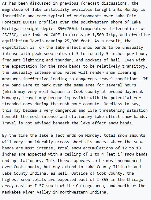
November 9, 2025 at 6:12 PM
This is a wild forecast discussion from NWS Chicago this morning.
mesonet.agron.iastate.edu/wx/afos/p.ph...
mesonet.agron.iastate.edu/wx/afos/p.ph...
Reposted by Meghan Gulledge

8 months ago I had a vision: what if we had a unified, track-based dataset of all severe events?
Still a lot of improvements I can make to the algorithm itself, but otherwise, looks like we have one now. I can't wait to see what we can do with this 👀
Still a lot of improvements I can make to the algorithm itself, but otherwise, looks like we have one now. I can't wait to see what we can do with this 👀
November 7, 2025 at 7:42 PM
8 months ago I had a vision: what if we had a unified, track-based dataset of all severe events?
Still a lot of improvements I can make to the algorithm itself, but otherwise, looks like we have one now. I can't wait to see what we can do with this 👀
Still a lot of improvements I can make to the algorithm itself, but otherwise, looks like we have one now. I can't wait to see what we can do with this 👀
Reposted by Meghan Gulledge

Out of all the stats that will be in history books from Melissa, this is the most astounding to me.
GLM data was recording a peak flash rate of 700 strikes per minute — nearly 12 per second — as it made landfall on Jamaica. That’s rewriting our understanding flash density in tropical cyclones.
GLM data was recording a peak flash rate of 700 strikes per minute — nearly 12 per second — as it made landfall on Jamaica. That’s rewriting our understanding flash density in tropical cyclones.

November 6, 2025 at 11:47 PM
Out of all the stats that will be in history books from Melissa, this is the most astounding to me.
GLM data was recording a peak flash rate of 700 strikes per minute — nearly 12 per second — as it made landfall on Jamaica. That’s rewriting our understanding flash density in tropical cyclones.
GLM data was recording a peak flash rate of 700 strikes per minute — nearly 12 per second — as it made landfall on Jamaica. That’s rewriting our understanding flash density in tropical cyclones.
Reposted by Meghan Gulledge

Multi-panel view of the last few days of Hurricane Melissa:
↖️ GOES-19 infrared brightness temp
↗️ GOES-19 visible satellite
↙️ Hurricane hunter planes & flight paths
↘️ Recon-derived flight level wind swath
⬇️ Estimated minimum pressure from recon dropsondes
↖️ GOES-19 infrared brightness temp
↗️ GOES-19 visible satellite
↙️ Hurricane hunter planes & flight paths
↘️ Recon-derived flight level wind swath
⬇️ Estimated minimum pressure from recon dropsondes
October 29, 2025 at 10:14 PM
Multi-panel view of the last few days of Hurricane Melissa:
↖️ GOES-19 infrared brightness temp
↗️ GOES-19 visible satellite
↙️ Hurricane hunter planes & flight paths
↘️ Recon-derived flight level wind swath
⬇️ Estimated minimum pressure from recon dropsondes
↖️ GOES-19 infrared brightness temp
↗️ GOES-19 visible satellite
↙️ Hurricane hunter planes & flight paths
↘️ Recon-derived flight level wind swath
⬇️ Estimated minimum pressure from recon dropsondes
Reposted by Meghan Gulledge
Thanks to some vigilant friends out there, I have a nearly-complete 87-hour radar loop of #Melissa 's approach to #Jamaica. The loop abruptly ends when the radar is lost (either loss of communication with it or loss of the actual structure).
bmcnoldy.earth.miami.edu/tropics/radar/
bmcnoldy.earth.miami.edu/tropics/radar/
October 29, 2025 at 12:03 PM
Thanks to some vigilant friends out there, I have a nearly-complete 87-hour radar loop of #Melissa 's approach to #Jamaica. The loop abruptly ends when the radar is lost (either loss of communication with it or loss of the actual structure).
bmcnoldy.earth.miami.edu/tropics/radar/
bmcnoldy.earth.miami.edu/tropics/radar/
Reposted by Meghan Gulledge

Time-lapse of #Melissa becoming one of the strongest cyclones ever recorded in the Atlantic basin.
#hurricanemelissa #wx
#hurricanemelissa #wx
October 29, 2025 at 1:46 AM
Time-lapse of #Melissa becoming one of the strongest cyclones ever recorded in the Atlantic basin.
#hurricanemelissa #wx
#hurricanemelissa #wx
Reposted by Meghan Gulledge

Hurricane Melissa this morning up until landfall.
Just incredible imagery of an historic storm.
Just incredible imagery of an historic storm.
October 28, 2025 at 6:11 PM
Hurricane Melissa this morning up until landfall.
Just incredible imagery of an historic storm.
Just incredible imagery of an historic storm.
Reposted by Meghan Gulledge

#Melissa's landfall intensity of 185 mph/892 mb ties it with the Florida Key's Labor Day Hurricane of 1935 as the record minimum pressure of any TC making landfall *anywhere* the NATL basin. I feel for the residents of #Jamaica 😞
Zoomed in G19 visible meso loop courtesy of @cyclonicwx.bsky.social
Zoomed in G19 visible meso loop courtesy of @cyclonicwx.bsky.social
October 28, 2025 at 5:14 PM
#Melissa's landfall intensity of 185 mph/892 mb ties it with the Florida Key's Labor Day Hurricane of 1935 as the record minimum pressure of any TC making landfall *anywhere* the NATL basin. I feel for the residents of #Jamaica 😞
Zoomed in G19 visible meso loop courtesy of @cyclonicwx.bsky.social
Zoomed in G19 visible meso loop courtesy of @cyclonicwx.bsky.social
Reposted by Meghan Gulledge

12:24 PM EDT, 10/28: Infrared satellite imagery as #HurricaneMelissa skirts the Jamaican shore. The large feeder outer band, and symmetry of the core of the storm, is a classic example of a strong tropical cyclone.

October 28, 2025 at 4:25 PM
12:24 PM EDT, 10/28: Infrared satellite imagery as #HurricaneMelissa skirts the Jamaican shore. The large feeder outer band, and symmetry of the core of the storm, is a classic example of a strong tropical cyclone.
Reposted by Meghan Gulledge
Echoing colleagues: Think before you (re)post. #Melissa is about to impact a relatively poor part of Jamaica. I doubt we will know the true extent of the devastation for days or weeks.
Information vacuums fill with disinformation. Expect a lot of “breaking wind” on SM.
Map source: World Bank
Information vacuums fill with disinformation. Expect a lot of “breaking wind” on SM.
Map source: World Bank

October 28, 2025 at 3:12 PM
Echoing colleagues: Think before you (re)post. #Melissa is about to impact a relatively poor part of Jamaica. I doubt we will know the true extent of the devastation for days or weeks.
Information vacuums fill with disinformation. Expect a lot of “breaking wind” on SM.
Map source: World Bank
Information vacuums fill with disinformation. Expect a lot of “breaking wind” on SM.
Map source: World Bank
Reposted by Meghan Gulledge
Looking back at the rapid intensification of #Melissa, two things really stand out to me:
1) there were *5* consecutive six-hourly periods of RI
2) an RI period began when the storm was already at Category 4 intensity
The red entries here highlight when an RI period began (30+ kt in 24 hr).
1) there were *5* consecutive six-hourly periods of RI
2) an RI period began when the storm was already at Category 4 intensity
The red entries here highlight when an RI period began (30+ kt in 24 hr).

October 28, 2025 at 12:21 PM
Looking back at the rapid intensification of #Melissa, two things really stand out to me:
1) there were *5* consecutive six-hourly periods of RI
2) an RI period began when the storm was already at Category 4 intensity
The red entries here highlight when an RI period began (30+ kt in 24 hr).
1) there were *5* consecutive six-hourly periods of RI
2) an RI period began when the storm was already at Category 4 intensity
The red entries here highlight when an RI period began (30+ kt in 24 hr).
Reposted by Meghan Gulledge

1-minute #GOES19/#GOESEast Visible and Infrared images with plots of GLM Flash Points showed prolific lightning activity within the inner eyewall of Category 5 Hurricane #Melissa as it approaches the SW coast of Jamaica. Low-altitude mesovortices persist within the eye.
October 28, 2025 at 2:32 PM
1-minute #GOES19/#GOESEast Visible and Infrared images with plots of GLM Flash Points showed prolific lightning activity within the inner eyewall of Category 5 Hurricane #Melissa as it approaches the SW coast of Jamaica. Low-altitude mesovortices persist within the eye.
Reposted by Meghan Gulledge
10:25 AM EDT, 10/28: #HurricaneMelissa dropsonde finds surface winds of 198 MPH in southern eyewall.

October 28, 2025 at 2:26 PM
10:25 AM EDT, 10/28: #HurricaneMelissa dropsonde finds surface winds of 198 MPH in southern eyewall.