Mike Wulder
@mikewulder.bsky.social
1.3K followers
650 following
62 posts
Senior Research Scientist with the Canadian Forest Service. 🍁
#Landsat super-fan. #Lidar. #Forests. #Remotesensing. 🌲🛰
Member of the #OrderOfCanada. 🎖
📎https://www.researchgate.net/profile/Michael-Wulder
Posts
Media
Videos
Starter Packs
Pinned

Reposted by Mike Wulder


Reposted by Mike Wulder


Reposted by Mike Wulder


Reposted by Mike Wulder
Mike Wulder
@mikewulder.bsky.social
· Aug 29

Ramon MELSER | Postdoctoral Research Fellow | PhD in Forestry (Remote Sensing) | University of British Columbia, Vancouver | UBC | Research profile
Ramon MELSER, Postdoctoral Research Fellow | Cited by 13 | of University of British Columbia, Vancouver (UBC) | Read 4 publications | Contact Ramon MELSER
www.researchgate.net
Reposted by Mike Wulder
Reposted by Mike Wulder
Mike Wulder
@mikewulder.bsky.social
· Aug 27
Mike Wulder
@mikewulder.bsky.social
· Aug 27
Reposted by Mike Wulder


Reposted by Mike Wulder
Nikola Besic
@nikobesic.bsky.social
· Aug 24

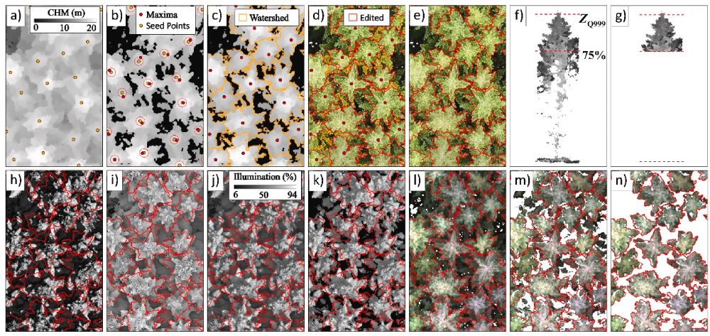
Retrieving yearly forest growth from satellite data: A deep learning based approach
High-resolution mapping of forest attributes is crucial for ecosystem monitoring and carbon budget assessments. Recent advancements have leveraged sat…
www.sciencedirect.com
Reposted by Mike Wulder
Mike Wulder
@mikewulder.bsky.social
· Aug 22
Reposted by Mike Wulder

Reposted by Mike Wulder


Reposted by Mike Wulder

Ramon Melser
@ramonmelser.bsky.social
· Aug 18
Reposted by Mike Wulder


Reposted by Mike Wulder


Reposted by Mike Wulder


Reposted by Mike Wulder