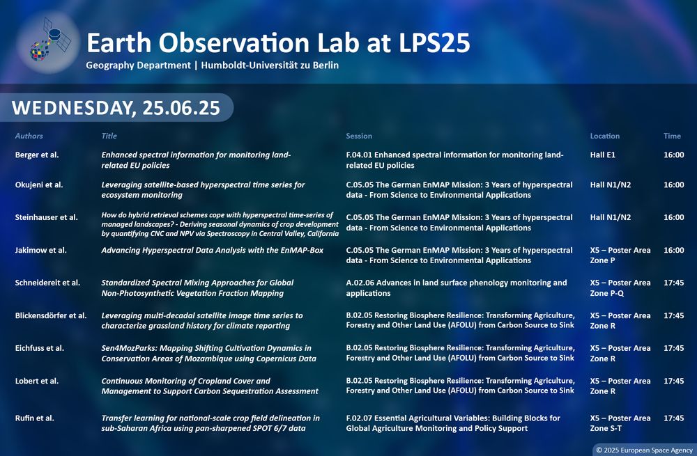
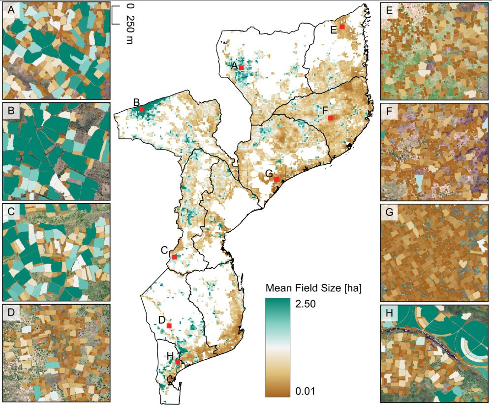
Philippe Rufin
@philrufin.bsky.social
350 followers 510 following 130 posts
Geographer interested in 🛰️ EarthObservation for 🌿agriculture, 💧water resources, and 🌍 sustainable land management. F.R.S. FNRS Postdoctoral Fellow 🇪🇺 Earth & Life Institute - UCLouvain 🇧🇪 Earth Observation Lab - HUBerlin 🇩🇪
Posts Media Videos Starter Packs
Pinned
philrufin.bsky.social
🌍 🛰️ 🌱 🌽👨🏿‍🌾🛖💻⚙️
Preprint on national-scale satellite-based crop field delineation in smallholder landscapes is out:
doi.org/10.48550/arX...
🌍 🛰️ 🌱 🌽👨🏿‍🌾🛖💻⚙️
National-scale map of mean field size across Mozambique. Selected zoom ins provide details on individual fields.
Reposted by Philippe Rufin
philrufin.bsky.social
Great to see this out - Shupel is a true role model, paving the way for female researchers from northern Nigeria!
humboldteolab.bsky.social
Using Remote Sensing and Agro-Ecosystem Modelling 🛰️🌽📈, Esther Shupel Ibrahim analyzes impacts of climate change and diseases on smallholder agriculture in Nigeria and develops strategies to support and empower smallholder farmers.
Find out more about her PhD research in this StoryMap:
arcg.is/1bG48K
Header Image of Maize field with a picture of Esther Shupel Ibrahim and text: Research for Smallholder Farmers' Food Security in Nigeria
Reposted by Philippe Rufin
stim3on.bsky.social
On July 3rd, astronaut Nichole Ayers photographed a rare Gigantic jet from the ISS. These upward directed electrical discharges extend 90-100 km high into the atmosphere.

I processed this image from the RAW file, adjusting the white balance, contrast and noise reduction.
Full res: flic.kr/p/2rhxqcK
Photograph taken from the International Space Station by astronaut Nichole Ayers, capturing a rare gigantic jet — an upward lightning discharge shooting from a thunderstorm about 90-100 km high into the upper atmosphere. The jet appears as a vivid purple and blue column of light that finely branches out toward the top where it turns into a vivid red color. It's rising from a brightly illuminated cloud top, surrounded by diffuse city lights from Northern Mexico and South Texas. Behind it is the curved limb of Earth with a green band from the airglow layer indicating the edge of the atmosphere. A portion of the space station’s robotic arm is visible in the foreground.
Reposted by Philippe Rufin
thirstygecko.bsky.social
Fascinating ... and a hopeful sign
philrufin.bsky.social
Joint effort by Pauline Hammer, Leon-Friedrich Thomas, Sá Nogueira Lisboa, Natasha Ribeiro, Almeida Sitoe, @hostertp.bsky.social & Patrick Meyfroidt! Thanks to Descartes Labs and @esa.int for providing access to SPOT6/7 data, and the F.R.S.-FNRS for funding the research!
philrufin.bsky.social
Our team had the opportunity to access SPOT6/7 data (1.5 m resolution) for Mozambique! We produced ~21 million individual field delineations for 2023, which allow unique insights into the spatial distribution of agriculture, field size and the linkages between agriculture and forest cover change!
philrufin.bsky.social
The reason behind it is oftentimes constrained access to satellite imagery at very high spatial resolution needed in these systems (also see bsky.app/profile/phil...).
philrufin.bsky.social
Commercial very-high-resolution satellite imagery is crucial for monitoring smallholder farming systems (SDG 2), but paywalls block innovation and progress.

We call for open access to these data for sustainability-centered research in @pnas.org!

Read the full text here: doi.org/10.1073/pnas...
Photograph of smallholder farmer presenting seeds in her hand.
philrufin.bsky.social
The literature on field delineation in smallholder systems remains relatively scarce and progress is slow overall (although cudos to the colleagues working on it). Therefore we don´t have field delineations at policy-relevant scales (e.g. national) where they are most needed.
philrufin.bsky.social
Smallholder-dominated landscapes are entirely different from the mechanized and consolidated landscapes (which are oftentimes considered for benchmarking AI models).
philrufin.bsky.social
Despite free access to petabytes of satellite data, cloud computing platforms, and a wealth of high-performing computer vision models, satellite-based field delineation simply doesn´t work in landscapes dominated by smallholders (fragmented, heterogeneous, and dynamic)!
Drone capture from Mozambique illustrating the landscape complexity in smallholder landscapes.
philrufin.bsky.social
🌍 🛰️ 🌱 🌽👨🏿‍🌾🛖💻⚙️
Preprint on national-scale satellite-based crop field delineation in smallholder landscapes is out:
doi.org/10.48550/arX...
🌍 🛰️ 🌱 🌽👨🏿‍🌾🛖💻⚙️
National-scale map of mean field size across Mozambique. Selected zoom ins provide details on individual fields.
Reposted by Philippe Rufin
globalecoguy.bsky.social
We have decided to ban the use of GenAI for research, writing & creative work at our organization.

In fact, we make people sign an agreement saying that their research, analysis, writing, and creative work are *theirs* and not done by GenAI.
Reposted by Philippe Rufin
carlbergstrom.com
Peer review meltdown in one diagram.

Greater emphasis on glamour journals leads people to try their luck with mediocre papers. This drains the review pool (they often have to be re-reviewed elsewhere). That drops the accuracy of peer review, creating more incentive to submit mediocre papers…
carlbergstrom.com
7. We show that this setup leads to a pernicious positive feedback loop. When submissions increase, more peer reviewers are required. Either current reviewers have to spread their effort thinner, or less qualified reviewers must be recruited. Either way, review accuracy drops.
Flow diagram. At the center is the key cycle: Authors reduce self-screening --> Reviewer pool becomes depleted --> Accuracy of review declines --> [back to] Authors reduce self-screening. 

Outside arrows lead to this central cycle.

Greater emphasis on elite journals --> authors reduce self-screening
More journals create more opportunities for fresh review --> reviewer pool becomes depleted
Common pool dilemma reduces desk rejection rates --> reviewer pool becomes depleted.

There is an additional cycle:

Accuracy of review declines --> Authors learn less from reviews --> Authors reduce self-screening
Reposted by Philippe Rufin
danielmu11er.bsky.social
The data cover 19 EU countries with up to 17 years of annual data. It includes detailed crop codes, farm identifiers, and organic cultivation status—crucial for analysing land-use changes and farming practices
danielmu11er.bsky.social
A comprehensive field- and farm-level land-use dataset from the Integrated Administration and Control System (IACS) is now available: doi.org/10.1038/s415... #OpenData #EUAgri #LandUse #SustainableFarming
Field and farm-level data on agricultural land use for the European Union - Scientific Data
Scientific Data - Field and farm-level data on agricultural land use for the European Union
doi.org
Reposted by Philippe Rufin
danielmu11er.bsky.social
A comprehensive field- and farm-level land-use dataset from the Integrated Administration and Control System (IACS) is now available: doi.org/10.1038/s415... #OpenData #EUAgri #LandUse #SustainableFarming
Field and farm-level data on agricultural land use for the European Union - Scientific Data
Scientific Data - Field and farm-level data on agricultural land use for the European Union
doi.org
philrufin.bsky.social
#LPS25 was a fantastic experience but let´s take a step back and reflect on the potential (and the role) of commercial EO data providers in contributing to pressing #sustainability challenges. Here´s a short recap of arguments from the scientific community: doi.org/10.1073/pnas...
To enhance sustainable development goal research, open up commercial satellite image archives | PNAS
To enhance sustainable development goal research, open up commercial satellite image archives
doi.org
Reposted by Philippe Rufin
humboldteolab.bsky.social
#LPS25 wildE presentation on High resolution reconstructions of Pan-European woody cover timeseries from 1990-2024 by Shawn Schneidereit upcoming in Hall F2 at 11:30h!
Announcement for upcoming Earth Observation Lab contribution at living planet symposium 2025:
Schneidereit et al.: High resolution reconstructions of Pan-European woody cover timeseries from 1990-2024
Session: A.02.04 Advances in Monitoring and Management of
Forest Ecosystems - PART 6
Where: Hall F2
When: Friday 27.06.25 / 11:30 h
Reposted by Philippe Rufin
giswqs.bsky.social
🎉 Happy to see that my "Introduction to GIS Programming" book has reached #1 in the Top Books category on Leanpub! 🚀 I've sold 200 copies in just 2 days! Huge thanks to the incredible #geospatial community for your amazing support! 🙏

Check it out: leanpub.com/gispro
Reposted by Philippe Rufin
humboldteolab.bsky.social
Don’t miss EOLab’s contributions to #LPS25 Session A.02.07 - Monitoring Grasslands and Rangelands from Space

Part 1 with Dr. Marcel Schwieder at 8:30
Part 2 with @lasseharkort.bsky.social at 11:30

See you at Room 1.34!
Announcement for upcoming Earth Observation Lab contribution at living planet symposium 2025:
Schwieder et al.:Evaluating Grassland Mowing Detection Algorithms Across Europe - Results of the Mowing Detection Intercomparison
Exercise (MODCiX)
Session: A.02.07 Monitoring grasslands and rangelands from space - PART 1
Where: Room 1.34
When: Friday 27.06.25 / 08:30 h Announcement for upcoming Earth Observation Lab contribution at living planet symposium 2025:
Harkort et al.: Mapping Fractional Vegetation Cover in Sub-Saharan
Rangelands Using Phenological Feature Spaces
Session: A.02.07 Monitoring grasslands and rangelands from space - PART 2
Where: Room 1.34
When: Friday 27.06.25 / 11:30 h
Reposted by Philippe Rufin
humboldteolab.bsky.social
SEN4MOZ - @eoafrica-rd.org collaboration between @humboldteolab.bsky.social and Universidade Eduardo Mondlane!
Poster presentation by @lennarteichfuss.bsky.social and João Chibue Domingos upcoming at X5 – Poster Area – Zone R.
More info: eolab.geographie.hu-berlin.de/research_pro...
Announcement for upcoming Earth Observation Lab contribution at living planet symposium 2025: 
Eichfuss et al.: Sen4MozParks: Mapping Shifting Cultivation Dynamics in Conservation Areas of Mozambique using Copernicus Data
Session: B.02.05 Restoring Biosphere Resilience: Transforming Agriculture, Forestry and Other Land Use (AFOLU) from Carbon Source to Sink
Where: X5 - Poster Area / Zone R
When: Wednesday 25.06.25 / 17:45 h
SEN4MOZ Poster and Author João Chibue Domingos
philrufin.bsky.social
Great in-person meeting of the entire SEN4MOZ @eoafrica-rd.org project team at #LPS25! @humboldteolab.bsky.social
philrufin.bsky.social
#LPS25 poster alert: National scale field delineation in #Mozambique using 1.5m SPOT data, mapping field size & linking to #deforestation. Come by @ Hall X5, Poster S18.
Reposted by Philippe Rufin
humboldteolab.bsky.social
Big day ahead at @esa.int’s #LPS25 with contributions by EOLab's @jakimowb.bsky.social, @philrufin.bsky.social, @lennarteichfuss.bsky.social and many more - come by!
List of Earth Observation Lab's contributions at living planet symposium 25