


Quentin Baquera
@qbaquera.bsky.social
Chasseur d'orages et d'aurores boréales || Photographe || Passionné par la météorologie et par les phénomènes extrêmes
https://instagram.com/qbaquera/?hl=fr
https://instagram.com/qbaquera/?hl=fr
Reposted by Quentin Baquera

PUNCH sees the noontime sky as you've never seen it before! ☀️🔭🛰️🧪

NASA’S PUNCH Releases Refined Images of Eruptions from Sun
NASA’s PUNCH (Polarimeter to Unify the Corona and Heliosphere) mission has released processed images of huge eruptions from the Sun, known as coronal mass
science.nasa.gov
December 18, 2025 at 9:31 PM
PUNCH sees the noontime sky as you've never seen it before! ☀️🔭🛰️🧪
Cet après-midi la probabilité d'avoir des phénomènes tourbillonnaires dans le NO de la France est marquée.
Des vents forts en basse couches couplé à une instabilité moyenne (mais assez forte dans les 1eres couches de l'atmosphère) sont attendus ajd.
Plus de détail dans la légende de l'image !
Des vents forts en basse couches couplé à une instabilité moyenne (mais assez forte dans les 1eres couches de l'atmosphère) sont attendus ajd.
Plus de détail dans la légende de l'image !

October 20, 2025 at 1:49 AM
Cet après-midi la probabilité d'avoir des phénomènes tourbillonnaires dans le NO de la France est marquée.
Des vents forts en basse couches couplé à une instabilité moyenne (mais assez forte dans les 1eres couches de l'atmosphère) sont attendus ajd.
Plus de détail dans la légende de l'image !
Des vents forts en basse couches couplé à une instabilité moyenne (mais assez forte dans les 1eres couches de l'atmosphère) sont attendus ajd.
Plus de détail dans la légende de l'image !
Reposted by Quentin Baquera

Two years ago today: atmospheric perfection over rural Oklahoma. I'd have believed in gods too if I saw this before knowing what it was. #photography
September 23, 2025 at 7:29 PM
Two years ago today: atmospheric perfection over rural Oklahoma. I'd have believed in gods too if I saw this before knowing what it was. #photography
Reposted by Quentin Baquera

Wildfire blazes erupted across the European continent this Summer. Data shows fires were above average for the majority of countries, breaking decade long records for both area burnt and number of fires.


September 7, 2025 at 11:22 AM
Wildfire blazes erupted across the European continent this Summer. Data shows fires were above average for the majority of countries, breaking decade long records for both area burnt and number of fires.
Reposted by Quentin Baquera

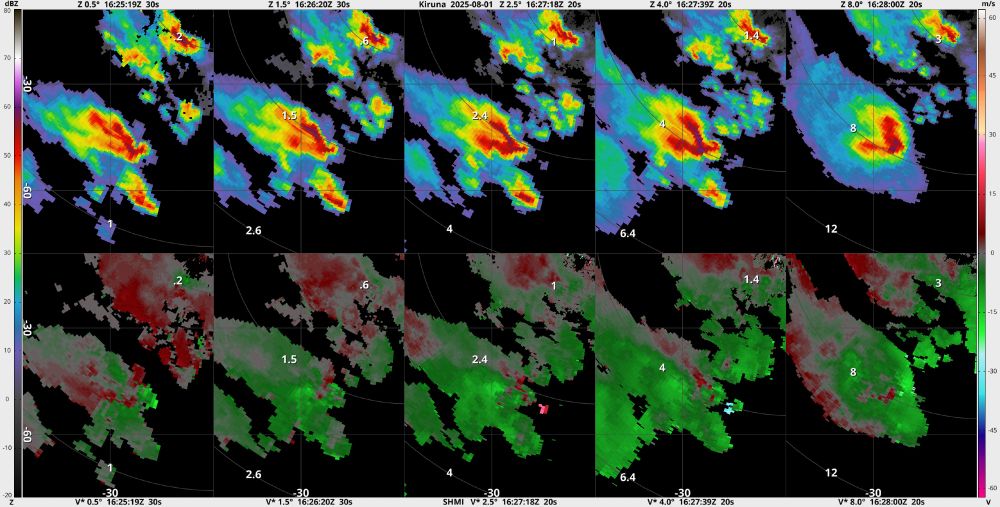
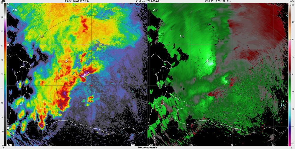
I have an update for NLradar, which includes auto-download for 4 more countries: Slovakia, Croatia, Romania and Sweden. Also included is 1 Austrian radar (Hochficht). Further, it add support for French NetCDF files with historical radar data (radarsmf.aeris-data.fr/acces-donnees/).
August 3, 2025 at 6:01 PM
I have an update for NLradar, which includes auto-download for 4 more countries: Slovakia, Croatia, Romania and Sweden. Also included is 1 Austrian radar (Hochficht). Further, it add support for French NetCDF files with historical radar data (radarsmf.aeris-data.fr/acces-donnees/).
Reposted by Quentin Baquera
We got an exceedingly rare view of #pyrocumulus as they were forming above the fire. Scientists are studying the composition and physical properties of smoke to better understand its meteorological and climate impacts.

July 28, 2025 at 8:02 PM
We got an exceedingly rare view of #pyrocumulus as they were forming above the fire. Scientists are studying the composition and physical properties of smoke to better understand its meteorological and climate impacts.
Reposted by Quentin Baquera
Picture taken over Southern France on July 26, 2025 from the research aircraft during the SILEX field campaign.
Researchers outfitted the aircraft with instruments to measure fire intensity and spread, meteorological conditions, and smoke plume properties.
#EUBURN
Researchers outfitted the aircraft with instruments to measure fire intensity and spread, meteorological conditions, and smoke plume properties.
#EUBURN

July 28, 2025 at 7:49 PM
Picture taken over Southern France on July 26, 2025 from the research aircraft during the SILEX field campaign.
Researchers outfitted the aircraft with instruments to measure fire intensity and spread, meteorological conditions, and smoke plume properties.
#EUBURN
Researchers outfitted the aircraft with instruments to measure fire intensity and spread, meteorological conditions, and smoke plume properties.
#EUBURN
Reposted by Quentin Baquera
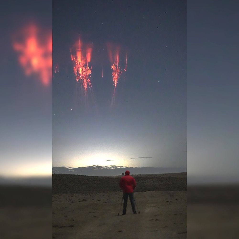
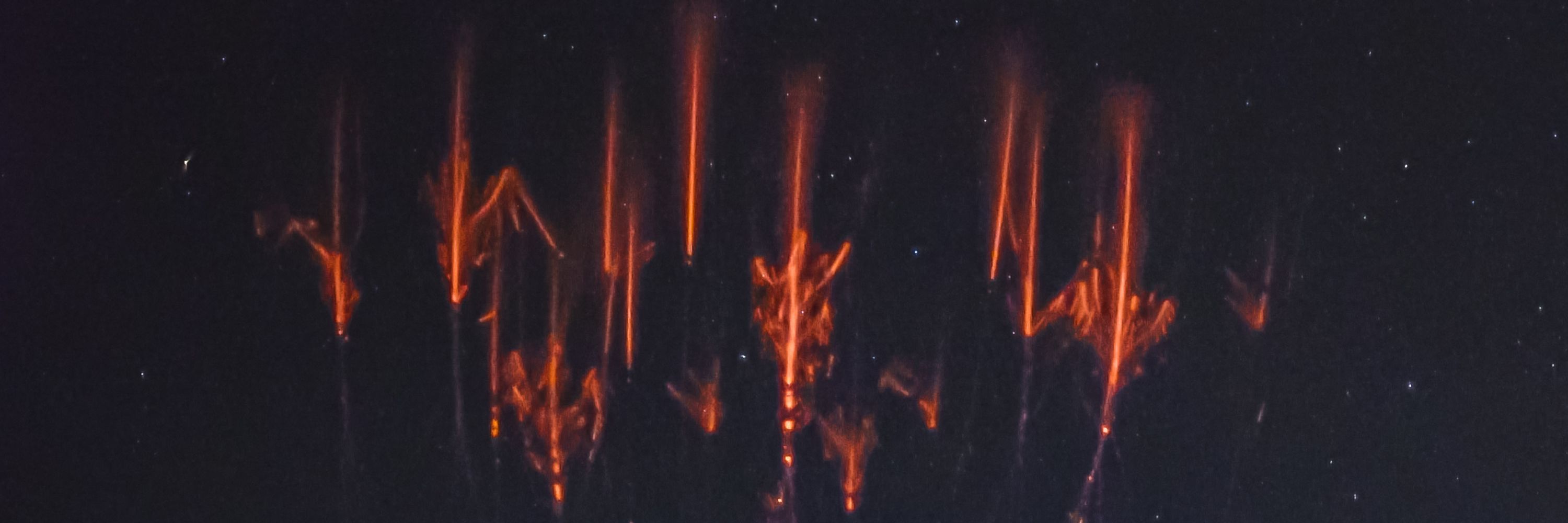
Last week I caught some of the most phenomenal events in the sky.
These sprites were so strong and so close that their colors reached maximum intensity from my vantage point.
The pink, purple, and blue colors at the lower 40-50km altitude are where the air is denser, meaning where molecules
These sprites were so strong and so close that their colors reached maximum intensity from my vantage point.
The pink, purple, and blue colors at the lower 40-50km altitude are where the air is denser, meaning where molecules

June 14, 2025 at 7:16 PM
Last week I caught some of the most phenomenal events in the sky.
These sprites were so strong and so close that their colors reached maximum intensity from my vantage point.
The pink, purple, and blue colors at the lower 40-50km altitude are where the air is denser, meaning where molecules
These sprites were so strong and so close that their colors reached maximum intensity from my vantage point.
The pink, purple, and blue colors at the lower 40-50km altitude are where the air is denser, meaning where molecules
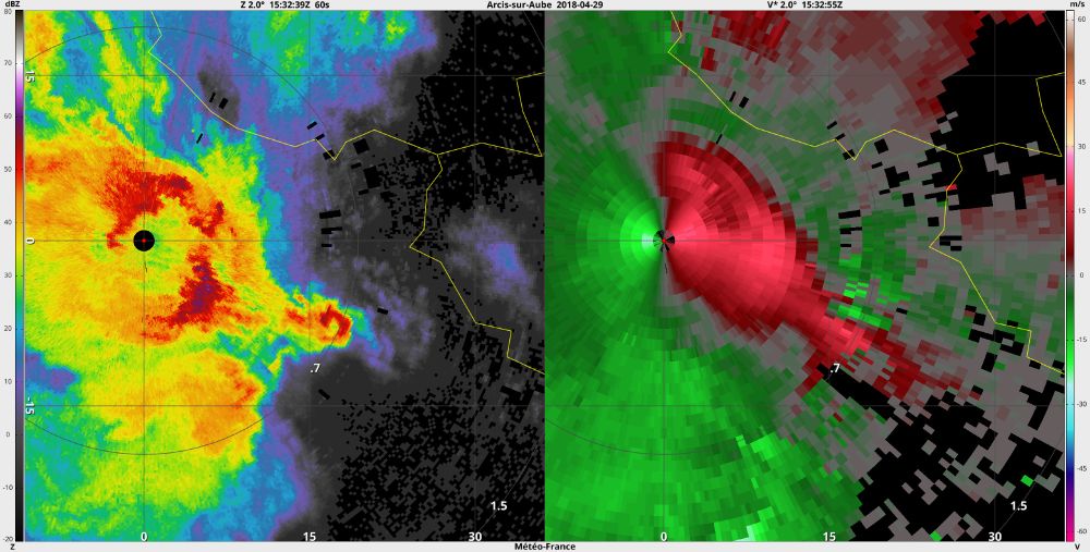
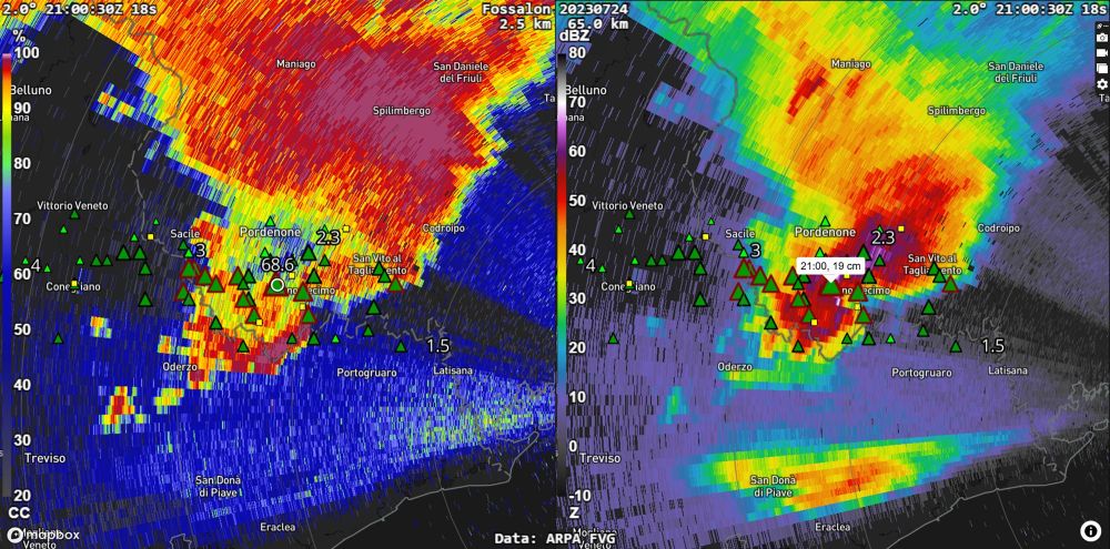
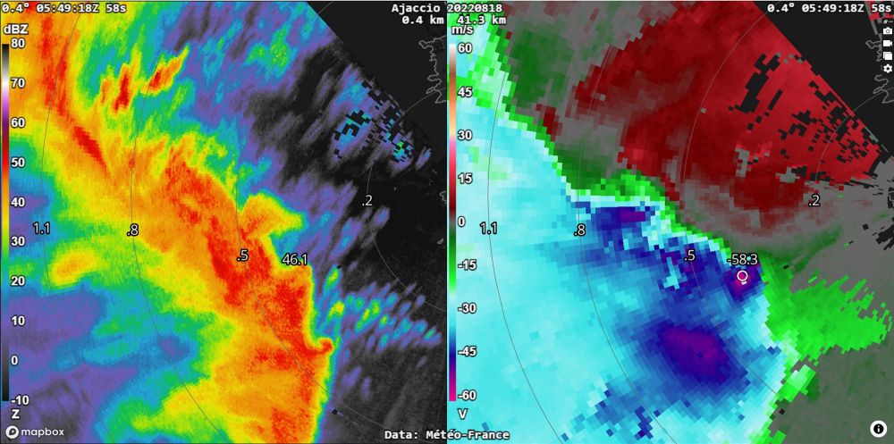
Un courant de densité (outflow bondary) est en train de passer sur l'Aquitaine. Il est très visible sur les images brutes du radar de Bordeaux ( et Momuy aussi )
Aura-t-il une incidence sur les orages possibles dans la soirée ? Réponse dans les prochaines heures !
Aura-t-il une incidence sur les orages possibles dans la soirée ? Réponse dans les prochaines heures !

May 2, 2025 at 1:14 PM
Un courant de densité (outflow bondary) est en train de passer sur l'Aquitaine. Il est très visible sur les images brutes du radar de Bordeaux ( et Momuy aussi )
Aura-t-il une incidence sur les orages possibles dans la soirée ? Réponse dans les prochaines heures !
Aura-t-il une incidence sur les orages possibles dans la soirée ? Réponse dans les prochaines heures !
Reposted by Quentin Baquera

Three charts based on our #C3S ERA5 dataset you shouldn’t miss this month:
📈 Daily global temperatures since 1940 – @hausfath.bsky.social
📈 Difference in soil moisture in Spain between March 2024 and 2025 – @drxeo.eu
📈 All-time record low for daily global #SeaIce extent – #C3S
📈 Daily global temperatures since 1940 – @hausfath.bsky.social
📈 Difference in soil moisture in Spain between March 2024 and 2025 – @drxeo.eu
📈 All-time record low for daily global #SeaIce extent – #C3S


March 31, 2025 at 7:54 AM
Three charts based on our #C3S ERA5 dataset you shouldn’t miss this month:
📈 Daily global temperatures since 1940 – @hausfath.bsky.social
📈 Difference in soil moisture in Spain between March 2024 and 2025 – @drxeo.eu
📈 All-time record low for daily global #SeaIce extent – #C3S
📈 Daily global temperatures since 1940 – @hausfath.bsky.social
📈 Difference in soil moisture in Spain between March 2024 and 2025 – @drxeo.eu
📈 All-time record low for daily global #SeaIce extent – #C3S
Reposted by Quentin Baquera

On finit la tournée des instituts du CNRS par @cnrs-insu.bsky.social qui étudie la Terre et l'astrophysique

March 26, 2025 at 4:46 PM
On finit la tournée des instituts du CNRS par @cnrs-insu.bsky.social qui étudie la Terre et l'astrophysique
Hey @bramvantveen.bsky.social !
Since the last update I can't launch NLRadar, and this is what I get.
Should I delete everything and install again ?
Since the last update I can't launch NLRadar, and this is what I get.
Should I delete everything and install again ?

March 24, 2025 at 2:33 AM
Hey @bramvantveen.bsky.social !
Since the last update I can't launch NLRadar, and this is what I get.
Should I delete everything and install again ?
Since the last update I can't launch NLRadar, and this is what I get.
Should I delete everything and install again ?
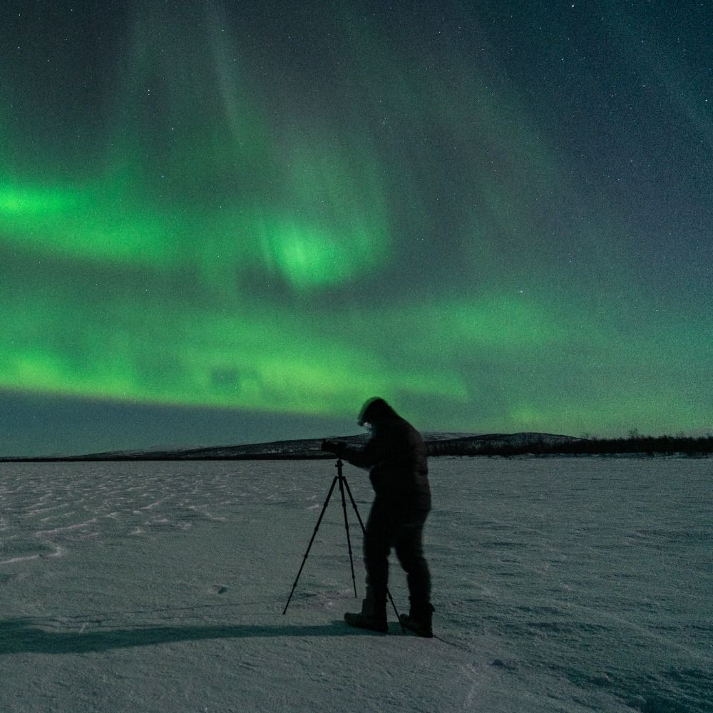
Once again, proof that even a small substorm is enough to make the aurora visible from locations far south of the oval ! (1800 km here !)
The webcams are all located in southern Germany.
And the Kp index was only..... 2+ 😅
The webcams are all located in southern Germany.
And the Kp index was only..... 2+ 😅


February 1, 2025 at 3:21 AM
Once again, proof that even a small substorm is enough to make the aurora visible from locations far south of the oval ! (1800 km here !)
The webcams are all located in southern Germany.
And the Kp index was only..... 2+ 😅
The webcams are all located in southern Germany.
And the Kp index was only..... 2+ 😅
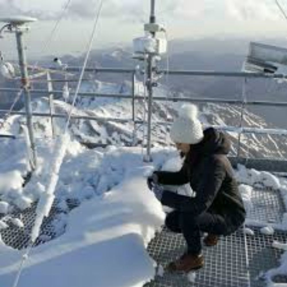
Possible épisode de PSC/NPS (Nuages Polaires Stratosphériques) au niveau de la Laponie entre le 1er et le 4 Février !
Possible outbreak of #PSC (Polar Stratospheric Clouds) over Lapland area between February 1st and 4th !
Possible outbreak of #PSC (Polar Stratospheric Clouds) over Lapland area between February 1st and 4th !


January 29, 2025 at 2:29 AM
Possible épisode de PSC/NPS (Nuages Polaires Stratosphériques) au niveau de la Laponie entre le 1er et le 4 Février !
Possible outbreak of #PSC (Polar Stratospheric Clouds) over Lapland area between February 1st and 4th !
Possible outbreak of #PSC (Polar Stratospheric Clouds) over Lapland area between February 1st and 4th !
Reposted by Quentin Baquera
...Mais les dégâts étaient encore plus importants pendant la tempête Xynthia en février 2010.
Rupture des données au plus fort de l'événement, mais les rafales ont probablement dépassé 240 km/h à ce moment là.
Rupture des données au plus fort de l'événement, mais les rafales ont probablement dépassé 240 km/h à ce moment là.
January 26, 2025 at 9:56 PM
...Mais les dégâts étaient encore plus importants pendant la tempête Xynthia en février 2010.
Rupture des données au plus fort de l'événement, mais les rafales ont probablement dépassé 240 km/h à ce moment là.
Rupture des données au plus fort de l'événement, mais les rafales ont probablement dépassé 240 km/h à ce moment là.
Reposted by Quentin Baquera
La dépression #Herminia provoque une tempête de pente aval sous le vent des Pyrénées, d'abord sur l'ouest du massif.
Sur le secteur très exposé de la crête d'Orgambidexka à Iraty, rafale maxi 213 km/h pour 121 de vent moyen.
Le record officiel y est de 228 km/h en décembre 2013 (tempête Dirk)
Sur le secteur très exposé de la crête d'Orgambidexka à Iraty, rafale maxi 213 km/h pour 121 de vent moyen.
Le record officiel y est de 228 km/h en décembre 2013 (tempête Dirk)
January 26, 2025 at 9:56 PM
La dépression #Herminia provoque une tempête de pente aval sous le vent des Pyrénées, d'abord sur l'ouest du massif.
Sur le secteur très exposé de la crête d'Orgambidexka à Iraty, rafale maxi 213 km/h pour 121 de vent moyen.
Le record officiel y est de 228 km/h en décembre 2013 (tempête Dirk)
Sur le secteur très exposé de la crête d'Orgambidexka à Iraty, rafale maxi 213 km/h pour 121 de vent moyen.
Le record officiel y est de 228 km/h en décembre 2013 (tempête Dirk)
Les rafales sont extrêmes sur les crêtes pyrénéennes. Cela fait plusieurs heures que le seuil des 200 km/h est franchi sur la fameuse station d'Iraty (64)
Source de la carte @meteociel.fr
Source de la carte @meteociel.fr

January 26, 2025 at 10:23 PM
Les rafales sont extrêmes sur les crêtes pyrénéennes. Cela fait plusieurs heures que le seuil des 200 km/h est franchi sur la fameuse station d'Iraty (64)
Source de la carte @meteociel.fr
Source de la carte @meteociel.fr
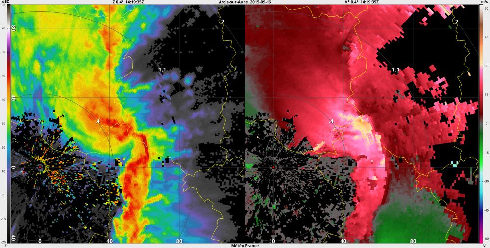
Hey @bramvantveen.bsky.social, any idea when this tool will be released ? Before the European storm season ? Even if it's for a fee (within reason😅) I'll subscribe when it comes out !
Here's a look at what I'm working on for @essl-ecss.bsky.social since half a year: www.youtube.com/watch?v=jAmn.... It's a fast web viewer for European radar data. It now displays data for a number of severe events, which will be used for ESSL's radar course next week (really looking forward 😀).

Web radar viewer
YouTube video by Bram van 't Veen
www.youtube.com
January 21, 2025 at 3:45 PM
Hey @bramvantveen.bsky.social, any idea when this tool will be released ? Before the European storm season ? Even if it's for a fee (within reason😅) I'll subscribe when it comes out !
Reposted by Quentin Baquera
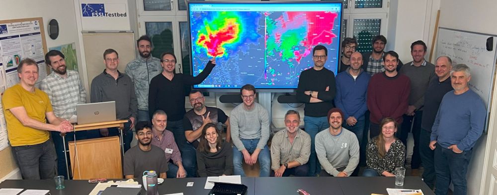
Last week we organized the first edition of the course on storm microphysics and radar meteorology, which was taught by Matt Kumjian of Pennsylvania State University. The course combined Matt's lectures with case studies using our new radar displayer developed by @bramvantveen.bsky.social
December 9, 2024 at 2:38 PM
Last week we organized the first edition of the course on storm microphysics and radar meteorology, which was taught by Matt Kumjian of Pennsylvania State University. The course combined Matt's lectures with case studies using our new radar displayer developed by @bramvantveen.bsky.social
Très surprenante éruption en #Islande près de #Grindavík
En effet aucun signe avant coureur, les séismes n'ont démarrés que quelques minutes avant que des fontaines de lave jaillissent du sol !
En effet aucun signe avant coureur, les séismes n'ont démarrés que quelques minutes avant que des fontaines de lave jaillissent du sol !

November 21, 2024 at 2:11 AM
Très surprenante éruption en #Islande près de #Grindavík
En effet aucun signe avant coureur, les séismes n'ont démarrés que quelques minutes avant que des fontaines de lave jaillissent du sol !
En effet aucun signe avant coureur, les séismes n'ont démarrés que quelques minutes avant que des fontaines de lave jaillissent du sol !
I don't think I've ever seen the sun surrounded by so many magnetic loops! The active zone in front of us over the next few days looks promising!
Je crois que j'ai rarement vu le soleil entouré d'autant de boucles magnétiques ! La zone qui nous arrive dessus est très prometteuse !
Je crois que j'ai rarement vu le soleil entouré d'autant de boucles magnétiques ! La zone qui nous arrive dessus est très prometteuse !
November 19, 2024 at 12:29 AM
I don't think I've ever seen the sun surrounded by so many magnetic loops! The active zone in front of us over the next few days looks promising!
Je crois que j'ai rarement vu le soleil entouré d'autant de boucles magnétiques ! La zone qui nous arrive dessus est très prometteuse !
Je crois que j'ai rarement vu le soleil entouré d'autant de boucles magnétiques ! La zone qui nous arrive dessus est très prometteuse !
Le risque de coup de vent sur les côtes aquitaines est non négligeable. En plus des cumuls plutôt importants (50/70mm en 24), les rafales pourraient causer pas mal de dégâts. Je serai sur les alentours du bassin d'Arcachon toute la journée de Jeudi pour faire des images


November 18, 2024 at 12:24 AM
Le risque de coup de vent sur les côtes aquitaines est non négligeable. En plus des cumuls plutôt importants (50/70mm en 24), les rafales pourraient causer pas mal de dégâts. Je serai sur les alentours du bassin d'Arcachon toute la journée de Jeudi pour faire des images
Pour agrémenter un peu ce nouveau compte, je vais essayez de rajouter quelques photos que j'ai pu prendre par le passé. Retour sur la comète C/2023 A3 (Tsuchinshan-ATLAS) que j'ai pris de long en large. Petit stacking pendant les jours où elle était le plus visible.

November 16, 2024 at 1:49 PM
Pour agrémenter un peu ce nouveau compte, je vais essayez de rajouter quelques photos que j'ai pu prendre par le passé. Retour sur la comète C/2023 A3 (Tsuchinshan-ATLAS) que j'ai pris de long en large. Petit stacking pendant les jours où elle était le plus visible.
Bonjour tout le monde !
On suit la tendance, qui dit qu'on passer de + en + de temps ici au lieu d'un autre réseau social 😅
L'ambiance à l'air beaucoup plus détente et scientifique, ce qui est super appréciable :)
On suit la tendance, qui dit qu'on passer de + en + de temps ici au lieu d'un autre réseau social 😅
L'ambiance à l'air beaucoup plus détente et scientifique, ce qui est super appréciable :)
November 16, 2024 at 1:38 PM
Bonjour tout le monde !
On suit la tendance, qui dit qu'on passer de + en + de temps ici au lieu d'un autre réseau social 😅
L'ambiance à l'air beaucoup plus détente et scientifique, ce qui est super appréciable :)
On suit la tendance, qui dit qu'on passer de + en + de temps ici au lieu d'un autre réseau social 😅
L'ambiance à l'air beaucoup plus détente et scientifique, ce qui est super appréciable :)