


Bram van 't Veen
@bramvantveen.bsky.social
Severe storms and radar | Creator of radar viewer NLradar | MSc Climate Physics | Working with radar data for @essl-ecss.bsky.social.
Reposted by Bram van 't Veen

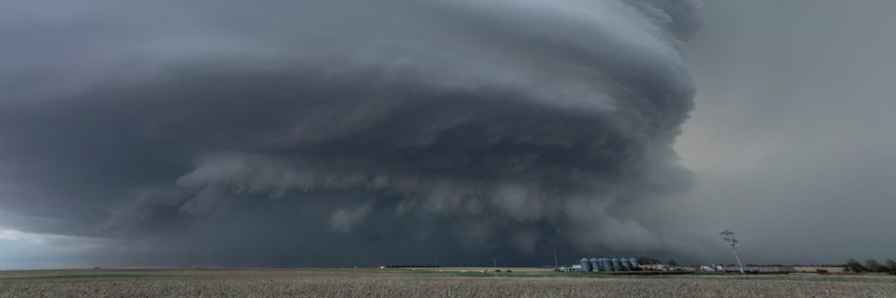
INCREDIBLE footage from earlier this evening from the 43 Fire just southwest of Woodward, Oklahoma!
Absolutely INSANE firewhirls in the main fire line as it very quickly advanced northeast towards Woodward!
Absolutely INSANE firewhirls in the main fire line as it very quickly advanced northeast towards Woodward!
February 18, 2026 at 1:50 AM
INCREDIBLE footage from earlier this evening from the 43 Fire just southwest of Woodward, Oklahoma!
Absolutely INSANE firewhirls in the main fire line as it very quickly advanced northeast towards Woodward!
Absolutely INSANE firewhirls in the main fire line as it very quickly advanced northeast towards Woodward!
Reposted by Bram van 't Veen

Overnight thunderstorms (at least one was supercellular) brought hail and intense wind damage in Apulia (between Oria and Brindisi), we will have to investigate to try and understand if there was a tornado. What a way to wake up!

February 17, 2026 at 7:18 AM
Overnight thunderstorms (at least one was supercellular) brought hail and intense wind damage in Apulia (between Oria and Brindisi), we will have to investigate to try and understand if there was a tornado. What a way to wake up!
Reposted by Bram van 't Veen

La Voix du Nord vient de publier un article dessus. C'est encore sommaire, mais on a déjà une idée de l'ampleur des dégâts :
www.lavoixdunord.fr/1675522/arti...
www.lavoixdunord.fr/1675522/arti...


February 16, 2026 at 8:49 PM
La Voix du Nord vient de publier un article dessus. C'est encore sommaire, mais on a déjà une idée de l'ampleur des dégâts :
www.lavoixdunord.fr/1675522/arti...
www.lavoixdunord.fr/1675522/arti...
While I had my focus on the northern one of 2 cells near FR-BE border this evening, the southern one actually produced a tornado. @corentinaugris.bsky.social found a report of damage in Cousoire (without photos yet), and radar shows a very convincing brief TDS here.


February 16, 2026 at 8:28 PM
While I had my focus on the northern one of 2 cells near FR-BE border this evening, the southern one actually produced a tornado. @corentinaugris.bsky.social found a report of damage in Cousoire (without photos yet), and radar shows a very convincing brief TDS here.
Impressive low-level meso currently. And a bit earlier there was a CC minimum inside the hook, but since it was embedded in a large region of low CC I doubt that it was a TDS.


February 16, 2026 at 6:36 PM
Impressive low-level meso currently. And a bit earlier there was a CC minimum inside the hook, but since it was embedded in a large region of low CC I doubt that it was a TDS.
Quite a suspicious looking storm near the French-Swiss border a while ago
February 16, 2026 at 4:50 PM
Quite a suspicious looking storm near the French-Swiss border a while ago
It's not the best time for the French radar network, with 5 radars inoperational currently (and not counting that 1 X-band close to Italy)

February 12, 2026 at 9:44 AM
It's not the best time for the French radar network, with 5 radars inoperational currently (and not counting that 1 X-band close to Italy)
Météo-France has now provided me with the full dataset for Trappes for the Ermont IF2 tornado, which killed 1 person and injured at least 9. In this storm-following loop you can see a strong RFD surge leading up to the tornado:
February 9, 2026 at 7:24 PM
Météo-France has now provided me with the full dataset for Trappes for the Ermont IF2 tornado, which killed 1 person and injured at least 9. In this storm-following loop you can see a strong RFD surge leading up to the tornado:
Reposted by Bram van 't Veen

ESWD - JAN 2026 - 3,494 #wx Reports
Fatalities: 29 (Avalanches: 18 | Winds: 8 | Floods/Tornadoes/Snowstorm: 1 each)
@essl-ecss.bsky.social @federicopavan.bsky.social @bramvantveen.bsky.social @alluringstorms.bsky.social @weatherhistory.bsky.social @meteomabe.bsky.social @meteohro.bsky.social
Fatalities: 29 (Avalanches: 18 | Winds: 8 | Floods/Tornadoes/Snowstorm: 1 each)
@essl-ecss.bsky.social @federicopavan.bsky.social @bramvantveen.bsky.social @alluringstorms.bsky.social @weatherhistory.bsky.social @meteomabe.bsky.social @meteohro.bsky.social

February 9, 2026 at 10:18 AM
ESWD - JAN 2026 - 3,494 #wx Reports
Fatalities: 29 (Avalanches: 18 | Winds: 8 | Floods/Tornadoes/Snowstorm: 1 each)
@essl-ecss.bsky.social @federicopavan.bsky.social @bramvantveen.bsky.social @alluringstorms.bsky.social @weatherhistory.bsky.social @meteomabe.bsky.social @meteohro.bsky.social
Fatalities: 29 (Avalanches: 18 | Winds: 8 | Floods/Tornadoes/Snowstorm: 1 each)
@essl-ecss.bsky.social @federicopavan.bsky.social @bramvantveen.bsky.social @alluringstorms.bsky.social @weatherhistory.bsky.social @meteomabe.bsky.social @meteohro.bsky.social
Reposted by Bram van 't Veen

Mit unserem neuen Data Viewer machen wir unsere Untersuchungsergebnisse gebündelt auf einer interaktiven Karte sichtbar. Er beinhaltet Schneisen, Schadenspunkte, Wirkungsrichtungen & einen Filter/Datenbrowser für gezielte Selektionen und Auswertungen.
➡️ torkud.de/2026/02/08/d...
➡️ torkud.de/2026/02/08/d...


February 8, 2026 at 6:42 PM
Mit unserem neuen Data Viewer machen wir unsere Untersuchungsergebnisse gebündelt auf einer interaktiven Karte sichtbar. Er beinhaltet Schneisen, Schadenspunkte, Wirkungsrichtungen & einen Filter/Datenbrowser für gezielte Selektionen und Auswertungen.
➡️ torkud.de/2026/02/08/d...
➡️ torkud.de/2026/02/08/d...
Reposted by Bram van 't Veen

🌪️Publication du rapport sur la tornade qui a frappé Mios (Gironde) le 31 janvier. L'enquête de terrain permet d'établir un contact au sol pendant + de 20 min, avec parcours total de 23,3 km. Intensité EF1 (135-175 km/h).
➡️dossier complet : urlr.me/sumVSA
➡️dossier complet : urlr.me/sumVSA

February 7, 2026 at 3:48 PM
🌪️Publication du rapport sur la tornade qui a frappé Mios (Gironde) le 31 janvier. L'enquête de terrain permet d'établir un contact au sol pendant + de 20 min, avec parcours total de 23,3 km. Intensité EF1 (135-175 km/h).
➡️dossier complet : urlr.me/sumVSA
➡️dossier complet : urlr.me/sumVSA
Reposted by Bram van 't Veen
En plus de la très médiatisée tornade de Mios, un autre phénomène venteux s'est produit hier, à 12h20, sur la commune de Saint-Simon-de-Pellouaille (Charente-Maritime). Les témoignages font état de dégâts sur les toitures et la végétation. Pour l'heure, nous n'avons qu'une seule image de dégâts.

February 1, 2026 at 12:37 PM
En plus de la très médiatisée tornade de Mios, un autre phénomène venteux s'est produit hier, à 12h20, sur la commune de Saint-Simon-de-Pellouaille (Charente-Maritime). Les témoignages font état de dégâts sur les toitures et la végétation. Pour l'heure, nous n'avons qu'une seule image de dégâts.
Reposted by Bram van 't Veen

The tornadic supercell south of Bordeaux might have cycled and produced a new (short-lived) tornado, given another possible TDS at the end of this loop:
January 31, 2026 at 12:07 PM
The tornadic supercell south of Bordeaux might have cycled and produced a new (short-lived) tornado, given another possible TDS at the end of this loop:
Reposted by Bram van 't Veen
Une tornade a été observée à Mios (Gironde) sous ce remarquable écho. Plusieurs dégâts sont signalés et la tornade a pu être filmée :
www.facebook.com/diane.chesie...
www.facebook.com/diane.chesie...
January 31, 2026 at 11:55 AM
Une tornade a été observée à Mios (Gironde) sous ce remarquable écho. Plusieurs dégâts sont signalés et la tornade a pu être filmée :
www.facebook.com/diane.chesie...
www.facebook.com/diane.chesie...
A radar loop of this almost certainly tornadic supercell SW of Bordeaux. A likely TDS is visible at the last 2 scans. It could have hit places such as Arnauton and Argilas @corentinaugris.bsky.social
January 31, 2026 at 11:22 AM
A radar loop of this almost certainly tornadic supercell SW of Bordeaux. A likely TDS is visible at the last 2 scans. It could have hit places such as Arnauton and Argilas @corentinaugris.bsky.social
Possible tornado SW of Bordeaux now

January 31, 2026 at 11:09 AM
Possible tornado SW of Bordeaux now
Tornado potential exists in SW France today with these storms moving in from the Atlantic, in an environment with modest CAPE and quite some streamwise vorticity due to curved hodographs.


January 31, 2026 at 10:57 AM
Tornado potential exists in SW France today with these storms moving in from the Atlantic, in an environment with modest CAPE and quite some streamwise vorticity due to curved hodographs.
Reposted by Bram van 't Veen
Remember this? Well, go check out the shot taken by Francesco Pepe on his Instagram! www.instagram.com/p/DUDkWKEigY...

January 30, 2026 at 10:34 AM
Remember this? Well, go check out the shot taken by Francesco Pepe on his Instagram! www.instagram.com/p/DUDkWKEigY...
Reposted by Bram van 't Veen
Fantastic waterspout in front of Cetraro, Calabria. Photo by Albertina Pepe

January 28, 2026 at 3:03 PM
Fantastic waterspout in front of Cetraro, Calabria. Photo by Albertina Pepe
Here is a short radar loop, with a marker along the damage track visible in the image on the left. The small region of greenish colors at 23:24Z nicely matches with the location of the damage, which increases confidence that it is actually a (faint) tornadic debris signature.
January 27, 2026 at 6:14 PM
Here is a short radar loop, with a marker along the damage track visible in the image on the left. The small region of greenish colors at 23:24Z nicely matches with the location of the damage, which increases confidence that it is actually a (faint) tornadic debris signature.
Reposted by Bram van 't Veen
De nouvelles informations nous sont parvenues sur ces deux phénomènes. Celui de Riocaud a pu être filmé par plusieurs caméras, confirmant la tornade :
www.facebook.com/reel/1285555...
www.facebook.com/reel/1285555...
January 27, 2026 at 1:40 PM
De nouvelles informations nous sont parvenues sur ces deux phénomènes. Celui de Riocaud a pu être filmé par plusieurs caméras, confirmant la tornade :
www.facebook.com/reel/1285555...
www.facebook.com/reel/1285555...
Last night France had another likely tornado event: x.com/bor1s/status.... Damage looks highly suspicious, as does radar, since it indicates a low-topped supercell with possible small tornadic debris signature (small area of greenish colors starting in hook at 23:24Z, then expanding next frame).
January 26, 2026 at 8:06 PM
Last night France had another likely tornado event: x.com/bor1s/status.... Damage looks highly suspicious, as does radar, since it indicates a low-topped supercell with possible small tornadic debris signature (small area of greenish colors starting in hook at 23:24Z, then expanding next frame).
Reposted by Bram van 't Veen
Cet après-midi, un phénomène venteux a causé d'importants dégâts sur la commune de Riocaud (Gironde). La toiture de l'église a notamment été emportée : www.sudouest.fr/gironde/libo...
January 25, 2026 at 8:37 PM
Cet après-midi, un phénomène venteux a causé d'importants dégâts sur la commune de Riocaud (Gironde). La toiture de l'église a notamment été emportée : www.sudouest.fr/gironde/libo...