QGIS
@qgis.fosstodon.org.ap.brid.gy
860 followers
0 following
18 posts
Official account of QGIS - the user friendly Open Source Geographic Information System
[bridged from https://fosstodon.org/@qgis on the fediverse by https://fed.brid.gy/ ]
Posts
Media
Videos
Starter Packs
Reposted by QGIS


Reposted by QGIS


Reposted by QGIS
Reposted by QGIS

Reposted by QGIS

Reposted by QGIS
Reposted by QGIS


Reposted by QGIS


Reposted by QGIS

Reposted by QGIS
Reposted by QGIS
Reposted by QGIS
Reposted by QGIS
QGIS
@qgis.fosstodon.org.ap.brid.gy
· Feb 12

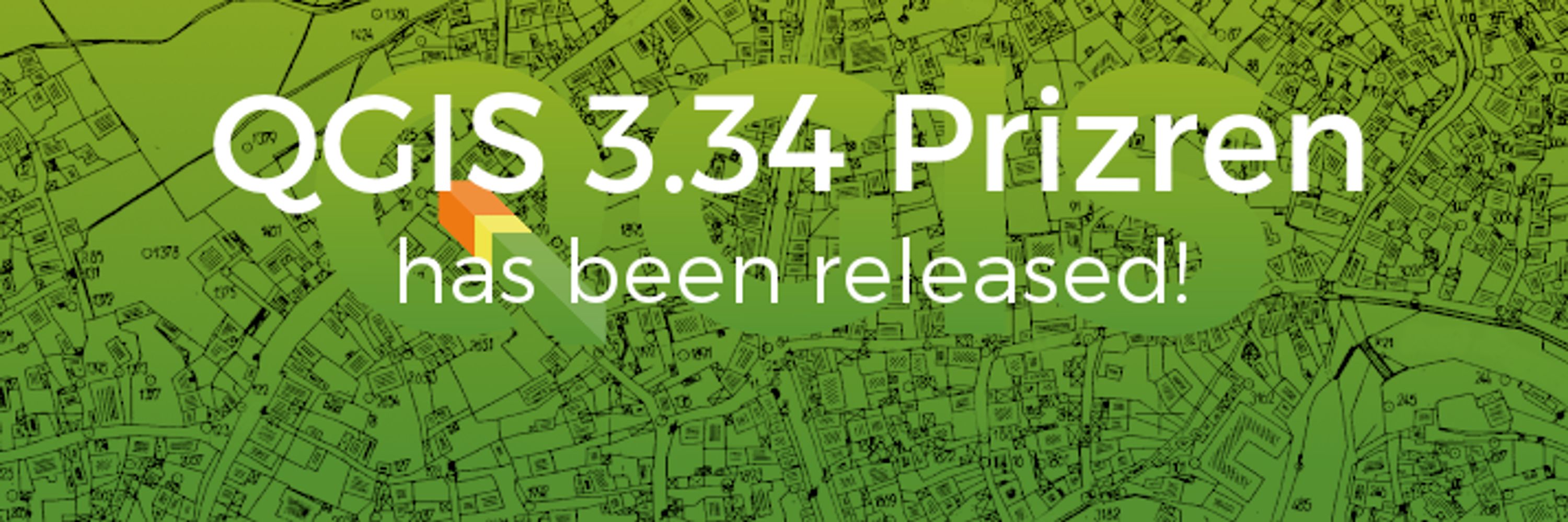
Plugin Update – January, 2025
<p>January, the first month of 2025, brought us 36 new plugins, published in the <a href="https://plugins.qgis.org/plugins/"><strong>QGIS plugin repository</strong></a><a href="https://plugins.qgis.org/plugins/">.</a></p>
<p>Here follows the quick overview in reverse chronological order. If any of the names or short descriptions catches your attention, you can find the direct link to the plugin page in the table below:</p>
<h2 class="wp-block-heading">Overview</h2>
<figure class="wp-block-table"><table class="has-fixed-layout"><tbody><tr><td><a href="https://plugins.qgis.org/plugins/ProjectSetup/"></a><strong><a href="https://plugins.qgis.org/plugins/gbif_extractor/"></a><a href="https://plugins.qgis.org/plugins/gbif_extractor/">GBIF Extractor</a></strong></td></tr><tr><td>Based on an extent, the user can download GBIF data.</td></tr><tr><td><a href="https://plugins.qgis.org/plugins/transliterator_plugin/"><strong></strong></a><strong><a href="https://plugins.qgis.org/plugins/transliterator_plugin/">Transliterator</a></strong></td></tr><tr><td>A plugin to transliterate Georgian script to Latin.</td></tr><tr><td><a href="https://plugins.qgis.org/plugins/carto/"><strong></strong></a><strong><a href="https://plugins.qgis.org/plugins/carto/">CARTO</a></strong></td></tr><tr><td>Seamless Cloud Data Warehouse Integration.</td></tr><tr><td><a href="https://plugins.qgis.org/plugins/open_google_maps/"><strong></strong></a><strong><a href="https://plugins.qgis.org/plugins/open_google_maps/">Open Google Maps</a></strong></td></tr><tr><td>Opens current map extent in Google Maps.</td></tr><tr><td><a href="https://plugins.qgis.org/plugins/planet_sandbox_plugin/"><strong></strong></a><strong><a href="https://plugins.qgis.org/plugins/planet_sandbox_plugin/">Planet Sandbox Plugin</a></strong></td></tr><tr><td>Plugin to explore Planet’s Sandbox data from the Planet Insights Platform. Right now it only displays a single layer, but makes it easy to see where the data is. This plugin will expand functionality in future versions.</td></tr><tr><td><a href="https://plugins.qgis.org/plugins/qsfcgal/"><strong></strong></a><strong><a href="https://plugins.qgis.org/plugins/qsfcgal/">QSFCGAL</a></strong></td></tr><tr><td>This plugin integrates SFCGAL functions into the QGIS Processing toolbox and expressions for advanced spatial analysis.</td></tr><tr><td><a href="https://plugins.qgis.org/plugins/sampling_time/"><strong></strong></a><strong><a href="https://plugins.qgis.org/plugins/sampling_time/">Sampling Time</a></strong></td></tr><tr><td>Performs multiple sampling methods on shapefile layers.</td></tr><tr><td><a href="https://plugins.qgis.org/plugins/layer_reverse/"><strong></strong></a><strong><a href="https://plugins.qgis.org/plugins/layer_reverse/">Layer Reverse</a></strong></td></tr><tr><td>Reverse order of highlighted layers.</td></tr><tr><td><a href="https://plugins.qgis.org/plugins/point_cloud_fr/"><strong></strong></a><strong><a href="https://plugins.qgis.org/plugins/point_cloud_fr/">PointCloudFR</a></strong></td></tr><tr><td>Downloads LiDAR tiles from IGN that intersect with the input AOI.</td></tr><tr><td><a href="https://plugins.qgis.org/plugins/layer_shifter/"><strong></strong></a><strong><a href="https://plugins.qgis.org/plugins/layer_shifter/">Layer CRS Shifter</a></strong></td></tr><tr><td>Coordinate System Shift for Layer.</td></tr><tr><td><a href="https://plugins.qgis.org/plugins/connect_odk/"><strong></strong></a><strong><a href="https://plugins.qgis.org/plugins/connect_odk/">Connector for ODK</a></strong></td></tr><tr><td>Connect to ODK Central, fetch submissions, and visualize field data on QGIS maps. Supports filtering, spatial analysis, and data export.</td></tr><tr><td><a href="https://plugins.qgis.org/plugins/team_zones/"><strong></strong></a><strong><a href="https://plugins.qgis.org/plugins/team_zones/">TeamArea Creator</a></strong></td></tr><tr><td>Create 3 Layers for each Team, Collecting Things like garbage and trace their route. Export collectionMarks to Excel.</td></tr><tr><td><a href="https://plugins.qgis.org/plugins/ls4sm/"><strong></strong></a><strong><a href="https://plugins.qgis.org/plugins/ls4sm/">Lateral spreading</a></strong></td></tr><tr><td>Lateral spreading for seismic microzonation.</td></tr><tr><td><a href="https://plugins.qgis.org/plugins/cql_filter_to_qgis_filter/"><strong></strong></a><strong><a href="https://plugins.qgis.org/plugins/cql_filter_to_qgis_filter/">WMS CQL Filter to QGIS Server Filter Request</a></strong></td></tr><tr><td>Transforms CQL_FILTER WMS request to a QGIS server compatible FILTER request.</td></tr><tr><td><a href="https://plugins.qgis.org/plugins/wqi_calculator/"><strong></strong></a><strong><a href="https://plugins.qgis.org/plugins/wqi_calculator/">WQICalculator</a></strong></td></tr><tr><td>WQICalculator is a QGIS plugin that allows automatic calculation of the Water Quality Index (WQI) using raster data of various physicochemical parameters as input.</td></tr><tr><td><a href="https://plugins.qgis.org/plugins/elasticsearch_loader/"><strong></strong></a><strong><a href="https://plugins.qgis.org/plugins/elasticsearch_loader/">Elasticsearch Loader</a></strong></td></tr><tr><td>Connects to an Elasticsearch index, executes a query, and loads the results as a QGIS layer.</td></tr><tr><td><a href="https://plugins.qgis.org/plugins/sankalan2/"><strong></strong></a><strong><a href="https://plugins.qgis.org/plugins/sankalan2/">Sankalan 2</a></strong></td></tr><tr><td>Tool for transferring data from and to Sankalan 2.0 Mobile App for field survey.</td></tr><tr><td><a href="https://plugins.qgis.org/plugins/layer_color_plugin/"><strong></strong></a><strong><a href="https://plugins.qgis.org/plugins/layer_color_plugin/">Layer Color Plugin</a></strong></td></tr><tr><td>This plugin enables users to customize the background colors of layers and groups in the layer tree view, enhancing visual organization and project management.</td></tr><tr><td><a href="https://plugins.qgis.org/plugins/seismic_microzones_with_morphological_gradient_smg/"><strong></strong></a><strong><a href="https://plugins.qgis.org/plugins/seismic_microzones_with_morphological_gradient_smg/">Seismic microzones with morphological gradient</a></strong></td></tr><tr><td>This plugin identifies areas with a morphological gradient with slopes ≥15° within seismic zones (input vector file) starting from the DTM.</td></tr><tr><td><a href="https://plugins.qgis.org/plugins/raster_stats_plus/"><strong></strong></a><strong><a href="https://plugins.qgis.org/plugins/raster_stats_plus/">Raster Stats Plus</a></strong></td></tr><tr><td>Calculates detailed statistics of a selected raster layer, allows you to choose the band via a menu, and generates histogram and Gaussian curve plots.</td></tr><tr><td><a href="https://plugins.qgis.org/plugins/landsklim/"><strong>Landsklim</strong></a></td></tr><tr><td>Spatial interpolations from quantitative data.</td></tr><tr><td><a href="https://plugins.qgis.org/plugins/rgd/"><strong>RGD Savoie Mont Blanc Plugin</strong></a></td></tr><tr><td>Plugin QGIS fournissant un accès simple aux flux de données géographiques du GIP RGD Savoie Mont Blanc et d’autres ressources géographiques utiles aux acteurs publics de Savoie et de Haute-Savoie ( plan cadastral, photographies aériennes, données d’urbanismes, cartes topographiques, données alimétriques, PCRS…). Fonctionnalités de recherche et consultation de données cadsatrales. Recherche d’adresse postale. Veuillez noter qu’un certain nombre de services accessibles par le plugin nécessitent d’avoir un accès autorisé accordé par la RGD Savoie Mont Blanc. <a class="__cf_email__" data-cfemail="20494e464f605247440e4652" href="https://blog.qgis.org/cdn-cgi/l/email-protection">[email protected]</a> pour toute création de compte.</td></tr><tr><td><a href="https://plugins.qgis.org/plugins/teleprop/"><strong>TeleProp</strong></a></td></tr><tr><td>Radio Propagation Fieldstrength</td></tr><tr><td><a href="https://plugins.qgis.org/plugins/afpolgis_data_connector/"><strong>AfpolGIS Data Connector</strong></a></td></tr><tr><td>This plugin allows you to load geospatial data from several Data Platforms; OnaData, ODK, KoboToolbox, ES World, GTS and DHIS.</td></tr><tr><td><a href="https://plugins.qgis.org/plugins/qgis_drone_flight_planner/"><strong>GeoFlight Planner</strong></a></td></tr><tr><td>A versatile QGIS plugin for drone flight planning, ensuring optimized flight paths and high-quality data capture.</td></tr><tr><td><a href="https://plugins.qgis.org/plugins/geology_from_points_and_lines/"><strong>Geology from points and lines</strong></a></td></tr><tr><td>Geoprocessing plugin to generate polygons and lines from lines and points with geological information.</td></tr><tr><td><a href="https://plugins.qgis.org/plugins/census_downloader/"><strong>Census Downloader</strong></a></td></tr><tr><td>Downloads Census Data.</td></tr><tr><td><a href="https://plugins.qgis.org/plugins/fbb/"><strong>FeaturesBoundingBox</strong></a></td></tr><tr><td>Show the BBox info for the selected features.</td></tr><tr><td><a href="https://plugins.qgis.org/plugins/raster_reclassifier/"><strong>Raster Reclassifier</strong></a></td></tr><tr><td>Reclassification of the raster layer using a table of range values extracted directly from the raster band, or defined directly by the user. The histogram of the raster is shown, reflecting the distribution of values within the minimum and maximum range of the selected reference band. Available languages: English, Italian and Spanish. ***ITALIANO*** Riclassificazione del layer raster tramite una tabella di valori di intervallo estratti direttamente dalla banda raster, oppure definiti direttamente dall’utente. Viene mostrato l’istogramma del raster, che riflette la distribuzione dei valori all’interno dell’intervallo minimo e massimo della banda di riferimento selezionata.</td></tr><tr><td><a href="https://plugins.qgis.org/plugins/qbeachball/"><strong>QBeachball</strong></a></td></tr><tr><td>Easily plot focal mechanisms (beachballs) onto a map.</td></tr><tr><td><a href="https://plugins.qgis.org/plugins/argentina_georref/"><strong>argentina_georef</strong></a></td></tr><tr><td>Obtiene información administrativa de Argentina a partir de coordenadas.</td></tr><tr><td><a href="https://plugins.qgis.org/plugins/staramaps/"><strong>Stara Maps</strong></a></td></tr><tr><td>Plugin para organizar arquivos de agricultura de precisão, facilitando a organização de mapas e arquivos em geral.</td></tr><tr><td><a href="https://plugins.qgis.org/plugins/nl_wfs_loader/"><strong>NL wfs_loader</strong></a></td></tr><tr><td>Deze plugin laad publiek beschikbare, maar lastig vindbare, WFS lagen.</td></tr><tr><td><a href="https://plugins.qgis.org/plugins/polygon_labeler_main/"><strong>Polygon Labeler</strong></a></td></tr><tr><td>Automatically generate and label polygons with custom names, and add the labels as a new attribute field to the attribute table.</td></tr><tr><td><a href="https://plugins.qgis.org/plugins/ahp/"><strong>ahp_application</strong></a></td></tr><tr><td>This QGIS plugin implements the Analytic Hierarchy Process (AHP) for suitability analysis.</td></tr><tr><td><a href="https://plugins.qgis.org/plugins/ts_manager/"><strong>Geospatial Gateway – GeospatialCloudServ and Tile Server Connection</strong></a></td></tr><tr><td>This plugin requires the purchase of either Windows Tile Server <a href="https://tileserver.techmaven.net" rel="nofollow">https://tileserver.techmaven.net</a> or Ready to Go Cloud or On-Prem/Edge Virtual Machine Solution <a href="https://geospatialcloudserv.com" rel="nofollow">https://geospatialcloudserv.com</a></td></tr></tbody></table></figure>
<div class="sharedaddy sd-like-enabled sd-sharing-enabled" id="jp-post-flair"><div class="sharedaddy sd-sharing-enabled"><div class="robots-nocontent sd-block sd-social sd-social-icon-text sd-sharing"><h3 class="sd-title">Share this:</h3><div class="sd-content"><ul><li class="share-twitter"><a class="share-twitter sd-button share-icon" data-shared="sharing-twitter-3218" href="https://blog.qgis.org/2025/02/11/__trashed/?share=twitter" rel="nofollow noopener noreferrer" target="_blank" title="Click to share on Twitter"><span>Twitter</span></a></li><li class="share-facebook"><a class="share-facebook sd-button share-icon" data-shared="sharing-facebook-3218" href="https://blog.qgis.org/2025/02/11/__trashed/?share=facebook" rel="nofollow noopener noreferrer" target="_blank" title="Click to share on Facebook"><span>Facebook</span></a></li><li class="share-end"></li></ul></div></div></div><div class="sharedaddy sd-block sd-like jetpack-likes-widget-wrapper jetpack-likes-widget-unloaded" data-name="like-post-frame-93459676-3218-67ad02d37b585" data-src="//widgets.wp.com/likes/index.html?ver=20250212#blog_id=93459676&post_id=3218&origin=qgisblog.wordpress.com&obj_id=93459676-3218-67ad02d37b585&domain=blog.qgis.org" data-title="Like or Reblog" id="like-post-wrapper-93459676-3218-67ad02d37b585"><div class="likes-widget-placeholder post-likes-widget-placeholder" style="height: 55px;"><span class="button"><span>Like</span></span> <span class="loading">Loading...</span></div><span class="sd-text-color"></span><a class="sd-link-color"></a></div>
<div class="jp-relatedposts" id="jp-relatedposts">
<h3 class="jp-relatedposts-headline"><em>Related</em></h3>
</div></div>
blog.qgis.org