


Simon Lee
@simonleewx.com
Lecturer in Atmospheric Science, University of St Andrews. Large-scale weather & climate variability, prediction & change. simonleewx.com
📣 New paper with Lorenzo Polvani published in @agu.org GRL!
Increasing Frequency and Persistence of the Summertime Greenland High Regime Not Captured by a Seasonal Prediction Model Very Large Ensemble
Open access: doi.org/10.1029/2025...
@earthscista.bsky.social @lamont.columbia.edu
Increasing Frequency and Persistence of the Summertime Greenland High Regime Not Captured by a Seasonal Prediction Model Very Large Ensemble
Open access: doi.org/10.1029/2025...
@earthscista.bsky.social @lamont.columbia.edu

January 10, 2026 at 11:47 AM
📣 New paper with Lorenzo Polvani published in @agu.org GRL!
Increasing Frequency and Persistence of the Summertime Greenland High Regime Not Captured by a Seasonal Prediction Model Very Large Ensemble
Open access: doi.org/10.1029/2025...
@earthscista.bsky.social @lamont.columbia.edu
Increasing Frequency and Persistence of the Summertime Greenland High Regime Not Captured by a Seasonal Prediction Model Very Large Ensemble
Open access: doi.org/10.1029/2025...
@earthscista.bsky.social @lamont.columbia.edu
ECMWF IFS stratospheric wave reflection index forecasts now online, just in time for a reflection event! simonleewx.com/ecmwf-ifs-st...
Reflection events tend to precede a transition from PT to AKR regimes and drive an abrupt cooling across large parts of North America doi.org/10.5194/wcd-...
Reflection events tend to precede a transition from PT to AKR regimes and drive an abrupt cooling across large parts of North America doi.org/10.5194/wcd-...

January 9, 2026 at 5:51 PM
ECMWF IFS stratospheric wave reflection index forecasts now online, just in time for a reflection event! simonleewx.com/ecmwf-ifs-st...
Reflection events tend to precede a transition from PT to AKR regimes and drive an abrupt cooling across large parts of North America doi.org/10.5194/wcd-...
Reflection events tend to precede a transition from PT to AKR regimes and drive an abrupt cooling across large parts of North America doi.org/10.5194/wcd-...
Storm Goretti down to 982 hPa at midday, analysed by the Met Office as a Shapiro–Keyser cyclone with a frontal fracture and warm seclusion.
S–K cyclones are those which can produce sting jets. However, the occurrence of strong surface wind gusts does not on its own confirm a sting jet is present.
S–K cyclones are those which can produce sting jets. However, the occurrence of strong surface wind gusts does not on its own confirm a sting jet is present.

January 8, 2026 at 2:26 PM
Storm Goretti down to 982 hPa at midday, analysed by the Met Office as a Shapiro–Keyser cyclone with a frontal fracture and warm seclusion.
S–K cyclones are those which can produce sting jets. However, the occurrence of strong surface wind gusts does not on its own confirm a sting jet is present.
S–K cyclones are those which can produce sting jets. However, the occurrence of strong surface wind gusts does not on its own confirm a sting jet is present.
Check out updated annual plots of the Weather Regime Index for 1979–2025 here simonleewx.com/north-americ...

January 7, 2026 at 5:56 PM
Check out updated annual plots of the Weather Regime Index for 1979–2025 here simonleewx.com/north-americ...
Updated time series of daily year-round North American weather regimes for 1 Jan 1979 to 31 Dec 2025 just published on Zenodo: doi.org/10.5281/zeno...
I plan to keep this dataset updated annually. Happy regime-ing!
I plan to keep this dataset updated annually. Happy regime-ing!

January 7, 2026 at 4:34 PM
Updated time series of daily year-round North American weather regimes for 1 Jan 1979 to 31 Dec 2025 just published on Zenodo: doi.org/10.5281/zeno...
I plan to keep this dataset updated annually. Happy regime-ing!
I plan to keep this dataset updated annually. Happy regime-ing!
Lunar halo last night — often a sign of wintry precipitation the next day — and a dusting of snow in St Andrews this morning.


January 6, 2026 at 9:58 AM
Lunar halo last night — often a sign of wintry precipitation the next day — and a dusting of snow in St Andrews this morning.
Fancy working somewhere with views like this less than a 10 min walk from your office?
Are you an outstanding scholar of international standing within the field of Earth and environmental sciences?
This could be the job for you: www.vacancies.st-andrews.ac.uk/Vacancies/I/...
Are you an outstanding scholar of international standing within the field of Earth and environmental sciences?
This could be the job for you: www.vacancies.st-andrews.ac.uk/Vacancies/I/...

January 5, 2026 at 5:12 PM
Fancy working somewhere with views like this less than a 10 min walk from your office?
Are you an outstanding scholar of international standing within the field of Earth and environmental sciences?
This could be the job for you: www.vacancies.st-andrews.ac.uk/Vacancies/I/...
Are you an outstanding scholar of international standing within the field of Earth and environmental sciences?
This could be the job for you: www.vacancies.st-andrews.ac.uk/Vacancies/I/...
Yorkshire Water’s Thruscross Reservoir on 16 September (left) and today (right) — now full and overflowing.
Another situation of a tremendous hydrological swing and another lucky escape from critical drought.
But we won’t always be so lucky…
Another situation of a tremendous hydrological swing and another lucky escape from critical drought.
But we won’t always be so lucky…


December 24, 2025 at 1:55 PM
Yorkshire Water’s Thruscross Reservoir on 16 September (left) and today (right) — now full and overflowing.
Another situation of a tremendous hydrological swing and another lucky escape from critical drought.
But we won’t always be so lucky…
Another situation of a tremendous hydrological swing and another lucky escape from critical drought.
But we won’t always be so lucky…
A beautiful day in St Andrews marking a change from recent weeks!
So far this month, Leuchars (nearest obs) has received 66.2mm of rain (105% of the December average) and only 16.5h of sunshine (31% of the December average).
So far this month, Leuchars (nearest obs) has received 66.2mm of rain (105% of the December average) and only 16.5h of sunshine (31% of the December average).

December 16, 2025 at 2:44 PM
A beautiful day in St Andrews marking a change from recent weeks!
So far this month, Leuchars (nearest obs) has received 66.2mm of rain (105% of the December average) and only 16.5h of sunshine (31% of the December average).
So far this month, Leuchars (nearest obs) has received 66.2mm of rain (105% of the December average) and only 16.5h of sunshine (31% of the December average).
According to ERA5, global sea-surface temperature anomalies have fallen back within the pre–2023 climate distribution, after running at unprecedented levels since March 2023.
However, this is still outrageously high given the last El Niño ended in early 2024.
pulse.climate.copernicus.eu
However, this is still outrageously high given the last El Niño ended in early 2024.
pulse.climate.copernicus.eu

December 15, 2025 at 2:06 PM
According to ERA5, global sea-surface temperature anomalies have fallen back within the pre–2023 climate distribution, after running at unprecedented levels since March 2023.
However, this is still outrageously high given the last El Niño ended in early 2024.
pulse.climate.copernicus.eu
However, this is still outrageously high given the last El Niño ended in early 2024.
pulse.climate.copernicus.eu
By the finest of margins, ERA5 shows a reversal of the daily-mean 10 hPa 60°N zonal-mean zonal winds on 28 November to –0.13 m/s.
That nominally ties with 28 Nov 1968 as the earliest major sudden stratospheric warming on record in ERA5 post-1958 (when stratospheric observations increased).
That nominally ties with 28 Nov 1968 as the earliest major sudden stratospheric warming on record in ERA5 post-1958 (when stratospheric observations increased).

December 8, 2025 at 8:13 PM
By the finest of margins, ERA5 shows a reversal of the daily-mean 10 hPa 60°N zonal-mean zonal winds on 28 November to –0.13 m/s.
That nominally ties with 28 Nov 1968 as the earliest major sudden stratospheric warming on record in ERA5 post-1958 (when stratospheric observations increased).
That nominally ties with 28 Nov 1968 as the earliest major sudden stratospheric warming on record in ERA5 post-1958 (when stratospheric observations increased).
Stunning lunar halo over northeast Fife this evening

December 4, 2025 at 9:47 PM
Stunning lunar halo over northeast Fife this evening
I've had the privilege of being Co-Editor-in-Chief of @rmets.org Weather since September 2020, first alongside @eddywx.bsky.social and then Regan Mudhar. Now please join me in welcoming Ben Maybee as the next Co-EiC! rmets.onlinelibrary.wiley.com/doi/10.1002/...

December 1, 2025 at 9:18 AM
I've had the privilege of being Co-Editor-in-Chief of @rmets.org Weather since September 2020, first alongside @eddywx.bsky.social and then Regan Mudhar. Now please join me in welcoming Ben Maybee as the next Co-EiC! rmets.onlinelibrary.wiley.com/doi/10.1002/...
North American weather regime forecasts have shifted from Greenland High toward Alaskan Ridge. This is consistent with forecasts of the forthcoming SSW shifting toward an event dominated by wave reflection and a quick reintensification of the vortex.
simonleewx.com/ecmwf_north_...
simonleewx.com/ecmwf_north_...

November 24, 2025 at 5:18 PM
North American weather regime forecasts have shifted from Greenland High toward Alaskan Ridge. This is consistent with forecasts of the forthcoming SSW shifting toward an event dominated by wave reflection and a quick reintensification of the vortex.
simonleewx.com/ecmwf_north_...
simonleewx.com/ecmwf_north_...
Just added "chiclet plots" to my website, showing the North American weather regime of the ensemble mean for the past 90 runs of the subseasonal NCEP GEFS & ECMWF IFS
GEFS: simonleewx.com/gefs_north_a...
IFS: simonleewx.com/ecmwf_north_...
GEFS: simonleewx.com/gefs_north_a...
IFS: simonleewx.com/ecmwf_north_...


November 21, 2025 at 4:14 PM
Just added "chiclet plots" to my website, showing the North American weather regime of the ensemble mean for the past 90 runs of the subseasonal NCEP GEFS & ECMWF IFS
GEFS: simonleewx.com/gefs_north_a...
IFS: simonleewx.com/ecmwf_north_...
GEFS: simonleewx.com/gefs_north_a...
IFS: simonleewx.com/ecmwf_north_...
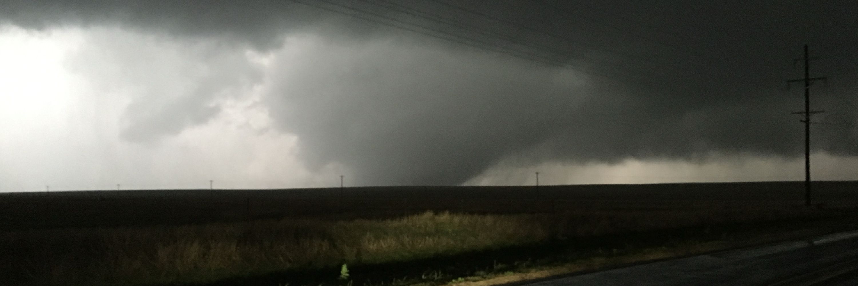
A stunning Cumulonimbus
snow shower cloud out over the North Sea in the northerly flow this afternoon. Dry and sunny in St Andrews as we’re sheltered by the Cairngorms to the north!
snow shower cloud out over the North Sea in the northerly flow this afternoon. Dry and sunny in St Andrews as we’re sheltered by the Cairngorms to the north!

November 20, 2025 at 4:10 PM
A stunning Cumulonimbus
snow shower cloud out over the North Sea in the northerly flow this afternoon. Dry and sunny in St Andrews as we’re sheltered by the Cairngorms to the north!
snow shower cloud out over the North Sea in the northerly flow this afternoon. Dry and sunny in St Andrews as we’re sheltered by the Cairngorms to the north!
With the imminent weak polar vortex/potential SSW, one similar recent(ish) year is 1996/97, which saw a very weak early season vortex (date-record weak U10-60 in Nov). 96/97 also had an established easterly QBO & cool ENSO Neutral/borderline La Niña. Extremely strong late-season vortex ensued.

November 19, 2025 at 6:40 PM
With the imminent weak polar vortex/potential SSW, one similar recent(ish) year is 1996/97, which saw a very weak early season vortex (date-record weak U10-60 in Nov). 96/97 also had an established easterly QBO & cool ENSO Neutral/borderline La Niña. Extremely strong late-season vortex ensued.
The ensemble mean of today's IFS subseasonal forecast now predicts the earliest major sudden stratospheric warming in reliable records, beating 28 November 1968.
Will this verify? 👀
charts.ecmwf.int/products/ext...
Will this verify? 👀
charts.ecmwf.int/products/ext...

November 13, 2025 at 8:17 PM
The ensemble mean of today's IFS subseasonal forecast now predicts the earliest major sudden stratospheric warming in reliable records, beating 28 November 1968.
Will this verify? 👀
charts.ecmwf.int/products/ext...
Will this verify? 👀
charts.ecmwf.int/products/ext...
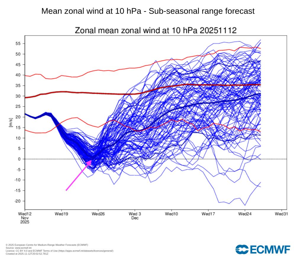
The ensemble mean from today's IFS subseasonal run almost predicts the earliest major sudden stratospheric warming on record 😮
Will be interesting to see if this signal progresses as it is just on the cusp of typical SSW prediction lead-times – daily runs of 101 members can still vary a fair bit
Will be interesting to see if this signal progresses as it is just on the cusp of typical SSW prediction lead-times – daily runs of 101 members can still vary a fair bit
November 12, 2025 at 8:32 PM
The ensemble mean from today's IFS subseasonal run almost predicts the earliest major sudden stratospheric warming on record 😮
Will be interesting to see if this signal progresses as it is just on the cusp of typical SSW prediction lead-times – daily runs of 101 members can still vary a fair bit
Will be interesting to see if this signal progresses as it is just on the cusp of typical SSW prediction lead-times – daily runs of 101 members can still vary a fair bit
Not the favoured outcome by any means, and I’m mostly posting this for fun (and my own interest in “unseen” model extremes), but the GFS 18Z has an historic major SSW on 26 November.
This would be the earliest in reliable records, beating 28 Nov 1968.
Not a forecast — just for interest!
This would be the earliest in reliable records, beating 28 Nov 1968.
Not a forecast — just for interest!

November 10, 2025 at 11:56 PM
Not the favoured outcome by any means, and I’m mostly posting this for fun (and my own interest in “unseen” model extremes), but the GFS 18Z has an historic major SSW on 26 November.
This would be the earliest in reliable records, beating 28 Nov 1968.
Not a forecast — just for interest!
This would be the earliest in reliable records, beating 28 Nov 1968.
Not a forecast — just for interest!
06Z GFS has remarkably persistent Greenland blocking for the full run, and a very weak stratospheric vortex by the end of it too. Posting this just for fun, but falls within what seems to be the range of possible outcomes based on recent modelling.
November 8, 2025 at 2:45 PM
06Z GFS has remarkably persistent Greenland blocking for the full run, and a very weak stratospheric vortex by the end of it too. Posting this just for fun, but falls within what seems to be the range of possible outcomes based on recent modelling.
Take this example from BBC Weather: the "forecast" (including the icon) is "light rain", but the probability of rain actually falling is 35% and described only as a "chance". That's unclear to me.

October 23, 2025 at 9:20 AM
Take this example from BBC Weather: the "forecast" (including the icon) is "light rain", but the probability of rain actually falling is 35% and described only as a "chance". That's unclear to me.
Storm Amy really sticks out in an otherwise dominantly slowly-varying & anticyclonic month (until today, that is!). Pressure data from northeast Fife (~10m above sea level)

October 19, 2025 at 12:06 PM
Storm Amy really sticks out in an otherwise dominantly slowly-varying & anticyclonic month (until today, that is!). Pressure data from northeast Fife (~10m above sea level)
Two headlines for the same BBC News article. One makes it much clearer this is a reference to global-mean temperatures (not UK-mean). Both unclear that they refer to 2°C total warming since preindustrial, not an additional 2°C from where we are today.


October 15, 2025 at 6:00 PM
Two headlines for the same BBC News article. One makes it much clearer this is a reference to global-mean temperatures (not UK-mean). Both unclear that they refer to 2°C total warming since preindustrial, not an additional 2°C from where we are today.
Even sunny St Andrews isn't immune from the anticyclonic gloom today ☁️

October 14, 2025 at 2:55 PM
Even sunny St Andrews isn't immune from the anticyclonic gloom today ☁️