TAMU Atmospheric Sciences
@tamuatmo.bsky.social
130 followers 13 following 47 posts
The Department of Atmospheric Sciences at Texas A&M University. Shaping the future of weather through innovative education and cutting-edge research.
Posts Media Videos Starter Packs
tamuatmo.bsky.social
A&MPLIFIED RESEARCH:
Volcanic ash can reshape high-altitude cirrus clouds, according to new research led by Dr. Xiaohong Liu of Texas A&M Atmospheric Sciences. The study offers fresh insight for climate models and geoengineering. 🌋☁️ Published in Science Advances.

artsci.tamu.edu/research/upd...
A volcano emitting a plume of smoke against a clear sky, with lush greenery at the base.
tamuatmo.bsky.social
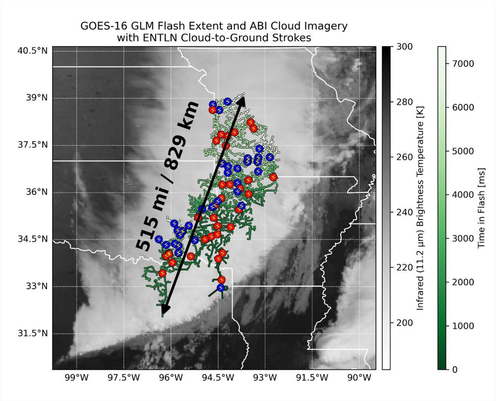
⚡ A bolt for the record books! Texas A&M Atmospheric Sciences' Dr. Timothy Logan helped confirm a lightning flash that stretched 515 miles—from Texas to Kansas. The rare “megaflash” is now the longest ever recorded.

Read more: tx.ag/ATMOLightningRecord
Satellite image from GOES-16 showing GLM Flash Extent and ABI Cloud Imagery with color-coded data points and a marked distance of 829 km across a regional map.
tamuatmo.bsky.social
📸 Checkout photos from this week’s House Committee on Science, Space, and Technology hearing.
Dr. John Nielsen-Gammon—Texas A&M Atmopsheric Sciences Professor—shared expert insight on advancing weather forecasting & research. 🌦️📊

Learn more about the hearing: science.house.gov/hearings?Con...
Four individuals seated at a long table during a congressional hearing, with name tags visible. Dr. Nielsen-Gammon sits at a table during a congressional hearing with microphones and nameplates visible, interacting in a formal setting. Five individuals posing for a photo in a hearing room, with the U.S. flag and state flags in the background, at the United States Capitol. Representative Franklin talks with Dr. Nielsen-Gammon in a hearing room.
tamuatmo.bsky.social
🏛️ Texas A&M Atmospheric Sciences professor, Dr. John Nielsen-Gammon, will testify before Congress Wednesday morning at 9 AM CT in a hearing titled “Protecting Lives and Property: Harnessing Innovative Technologies to Enhance Weather Forecasting.”

VIDEO: www.youtube.com/watch?v=YfgH...
Promotional banner for a hearing with the Committee on Science, Space and Technology, featuring an image of John Nielsen-Gammon alongside a graphic of connected blue lines and dots, representing a network.
tamuatmo.bsky.social
“It would have been next to impossible with present-day technology to get the internal dynamics of the storm right,” Texas A&M Atmospheric Sciences professor Dr. John Nielsen-Gammon told NBC News during his and Dr. Andrew Dessler’s visit about the recent TX floods.

www.nbcnews.com/science/envi...
Logo of Texas A&M University above the words 'Atmospheric Sciences,' set against a background featuring a weather satellite.
Reposted by TAMU Atmospheric Sciences
andrewdessler.com
this is an excellent discussion of the July 4th Hill Country floods by @travisabc13.bsky.social, ABC13's chief meteorologist and a graduate of our program, @tamuatmo.bsky.social.
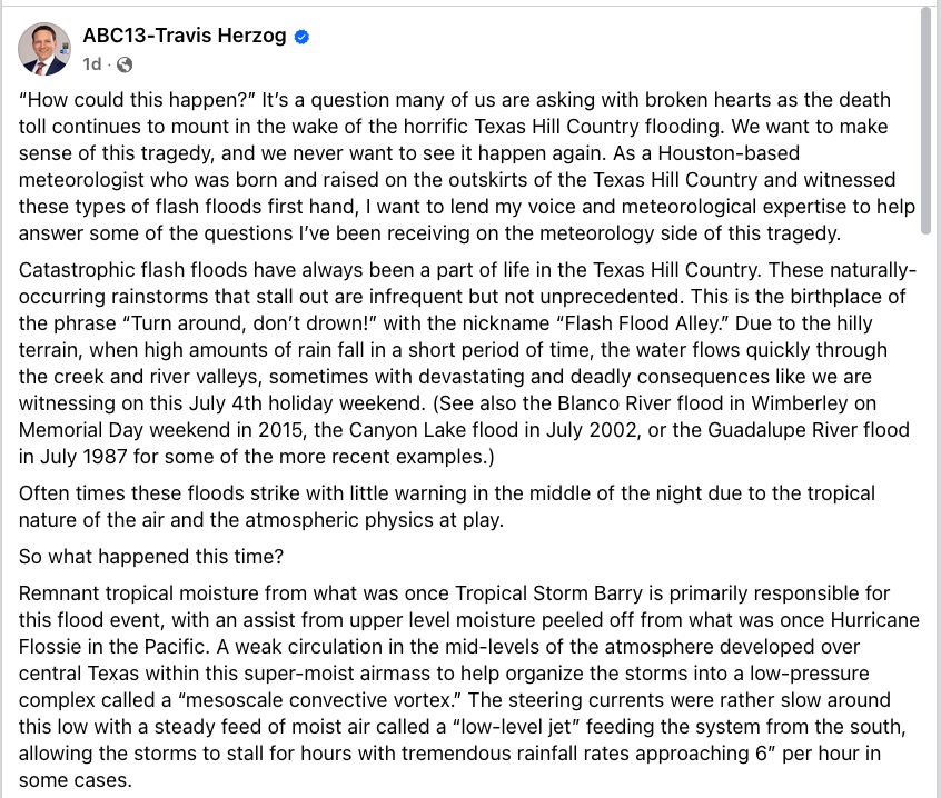
“How could this happen?” It’s a question many of us are asking with broken hearts as the death toll continues to mount in the wake of the horrific Texas Hill Country flooding. We want to make sense of this tragedy, and we never want to see it happen again. As a Houston-based meteorologist who was born and raised on the outskirts of the Texas Hill Country and witnessed these types of flash floods first hand, I want to lend my voice and meteorological expertise to help answer some of the questions I’ve been receiving on the meteorology side of this tragedy.
Catastrophic flash floods have always been a part of life in the Texas Hill Country. These naturally-occurring rainstorms that stall out are infrequent but not unprecedented. This is the birthplace of the phrase “Turn around, don’t drown!” with the nickname “Flash Flood Alley.” Due to the hilly terrain, when high amounts of rain fall in a short period of time, the water flows quickly through the creek and river valleys, sometimes with devastating and deadly consequences like we are witnessing on this July 4th holiday weekend. (See also the Blanco River flood in Wimberley on Memorial Day weekend in 2015, the Canyon Lake flood in July 2002, or the Guadalupe River flood in July 1987 for some of the more recent examples.)
Often times these floods strike with little warning in the middle of the night due to the tropical nature of the air and the atmospheric physics at play.
So what happened this time?
Remnant tropical moisture from what was once Tropical Storm Barry is primarily responsible for this flood event, with an assist from upper level moisture peeled off from what was once Hurricane Flossie in the Pacific. A weak circulation in the mid-levels of the atmosphere developed over central Texas within this super-moist airmass to help organize the storms into a low-pressure complex called a “mesoscale convective vortex.” The steering currents were rather slow around this low with a steady feed of moist air called a “l… How difficult is it to predict these flash floods?
When I was studying meteorology at Texas A&M over 20 years ago, I remember being taught that the most difficult thing to predict was how much rain would fall and where that rain would fall. While we have made tremendous progress in “quantitive precipitation forecasts” over the last two decades, this is largely still true today. No meteorologist could have told you with high confidence more than a few hours in advance that *this* much rain would fall in those *exact* locations.
But thanks to a forecasting technique known as “pattern recognition” (which comes with experience and studying past weather patterns) and the guidance offered up by more sophisticated “convection allowing models,” meteorologists already had a sense flash floods were possible on Thursday afternoon (when the National Weather Service issued a Flood Watch), and by Thursday evening they had a sense that something big was potentially brewing. I have attached the “mesoscale precipitation discussion” issued by NOAA’s Weather Prediction Center issued shortly after 6PM CT Thursday to put an extra focus on the dangerous flood ingredients that were coming together over the Hill Country. It is loaded with meteorological jargon, but it’s there for you to read if you so desire. I have also attached the “quantitative precipitation forecasts” (or QPF) from the high resolution “convection allowing models” (or CAMs) that came out Thursday morning. Some of them do show over 10” of rain falling north and west of San Antonio through 7AM on July 4th.
Yet even on Thursday evening, no meteorologist could have accurately predicted with high confidence the specific rain amounts that fell in the precise locations where they fell, and the atmosphere exceeded even the worst projections of the computer models both in coverage and amounts of heavy rain, as is often the case with tropical rain events over Texas.
Did recent staffing cuts and vacancies within the National Weath… I have looked back at the timeline of warnings issued by the National Weather Service along with communications in a National Weather Service Slack channel where NWS/NOAA meteorologists, broadcast media, and emergency managers share information during extreme weather events, and I agree with assessments I’ve seen from other meteorologists that the National Weather Service issued timely warnings as the event unfolded in real-time. The first Flash Flood Warning for Kerr County was issued around 1 a.m., and the first Flash Flood Emergency (highest level of flood warning issued in the most extreme, life-threatening situations) was issued around 4AM, which automatically triggers a “Wireless Emergency Alert” to all cell phones within the warned area (unless users have elected to turn off those alerts). I’m also told by houston’s former NWS Warning Coordination Meteorologist Dan Reilly that flash flood warnings issued hours earlier also contained a “considerable tag” that would’ve also triggered cell phone alerts in the middle of the night where cell service was available.
It certainly didn’t help the situation that the Austin/San Antonio NWS weather forecast office is understaffed by 22% and without a Warning Coordination Meteorologist, but I see no evidence yet that it hurt the situation either with what I know.
What I am not privy to are all the communications the NWS had with emergency managers and local officials in the middle of night outside of the Slack Channel we use to communicate and share information. Therefore, I cannot comment on what was done with the information and warnings pushed out by the National Weather Service, nor do I know how many meteorologists were staffed in the office to work this event. What role did our changing climate have in this flood?
The scientific body of evidence indicates that our warmer atmosphere and oceans increase the likelihood of these extreme precipitation events and the amount of rain that falls when they occur. The physics is pretty simple: Warmer oceans release more moisture into the atmosphere, and warmer air also holds more moisture. This enhances rainfall amounts above and beyond what would happen in a cooler world with cooler oceans.
What about cloud seeding? (Added at 2PM because of all the genuine questions about it.)
Cloud seeding cannot create a storm of this magnitude or size. In fact, cloud seeding cannot even create a single cloud. All it can do is take an existing cloud and enhance the rainfall by up to 20%. Most estimates have the rainfall enhancement in a much lower range. I am unaware of any active cloud seeding operations that occurred on Thursday night, but it is physically impossible for that to have created this weather system. This is a matter of scale. If I blow out a candle with my breath, does that mean I can then go blow out a raging wildfire? It is the same with cloud-seeding. For more, see this excellent report by my ABC colleague Ginger Zee: https://abcnews.go.com/.../ginger-zee-clears-air-cloud...
There are many other questions that remain, like what can be done to protect people from future floods, and what can we do to help now? Hopefully there will be changes made and systems put in place to help protect people in the Hill Country from future flash floods that occur in the middle of the night, and as soon as I have a list compiled of ways to help the flood victims and their families, I will share it here.
For now on this Day of Prayer in Texas, my prayers remain with the missing, the families of the flood victims, the first responders, and those tasked with leading us through the aftermath. 🙏🏻 🙏🏻🙏🏻
tamuatmo.bsky.social
Following the TX tragic floods, TAMU ATMO's Dr. Andrew Dessler spoke with a number of outlets including ABC News, ImpactAlpha & On the Climate Brink about what is causing this extreme rain.
🔗 abcnews.go.com/US/extreme-w...
🔗 impactalpha.com/investments-...
🔗 www.theclimatebrink.com/p/update-on-...
Flooded river with shrubs partially submerged in water, surrounded by lush greenery. The image includes the Texas A&M University Atmospheric Sciences logo at the top left corner.
tamuatmo.bsky.social
Over the last three years, retail electricity prices have climbed faster than inflation. CBS News recently featured Texas A&M Atmospheric Sciences professor Dr. Andrew Dessler and his research on how a changing climate is making it more costly to keep our homes cool.
www.cbsnews.com/.../how-clim...
Two people examining a weather map on a large screen, displaying a satellite image of a storm, in a room labeled "Texas A&M University Atmospheric Sciences." The screenshot includes a logo for "CBS Mornings.
tamuatmo.bsky.social
🌀 Hailstorms, floods & tornados cause damage—but are we tracking the costs right? Recently, Texas A&M Atmospheric Sciences professors, Dr. John Nielsen-Gammon & Dr. William Baule, uncovered flaws in how storm losses are estimated—and what we can do better. 🌩️📉

theconversation.com/extreme-weat...
Promotional graphic from Texas A&M University discussing why extreme weather costs remain a mystery. Features images of two faculty members from the Department of Atmospheric Sciences and a background photo depicting a hail-covered street.
tamuatmo.bsky.social
Congrats also to Texas A&M Atmospheric Sciences instructional assistant prof, Dr. Erik Nielsen, on winning the 2025 College of Arts & Sciences Early Career Teaching Award! His hands-on approach, from storm chasing to global programs, brings weather to life for students. ⛈️🌎

🔗 tx.ag/2025ArtSciAwards
Dean Mark Zoran and Dr. Erik Nielsen standing in front of a banner for Texas A&M University College of Arts & Sciences. Zoran is presenting Nielsen with an Early Career Teaching Award.
tamuatmo.bsky.social
Congrats to Texas A&M Atmospheric Sciences professor, Dr. Xiaohong Liu, on winning the 2025 College of Arts & Sciences Research Impact Award! His groundbreaking work on aerosol-cloud interactions and climate modeling is transforming Earth system science. 🌍☁️

Read more: tx.ag/2025ArtSciAwards
Dean Mark Zoran and Dr. Xiaohong Liu standing in front of a banner for Texas A&M University College of Arts & Sciences. Zoran is presenting Liu with a Research Impact Award.
tamuatmo.bsky.social
A recent CBS News article reports that the 2025 Atlantic hurricane season is expected to be 125% more active than average. Texas A&M Atmopsheric Sciences Assistant Professor Dr. Kelly Núñez Ocasio breaks down the forces shaping the season—and what forecasts are missing. tx.ag/2025HurricaneSeason
A 2023 map showing Hurricanes Idalia and Franklin reflects the intensity of storms in the Atlantic.
tamuatmo.bsky.social
Congratulations to Texas A&M Atmospheric Science Assistant Professor Dr. Yue Zhang for receiving a NSF CAREER Award for Pollution Research. Read more about the big honor! 🏭
tx.ag/ZhangNSFCareer
Image showing the National Science Foundation (NSF) logo alongside the text "CAREER Award", with Dr. Yue Zhang wearing a blue suit and a Texas A&M University Atmospheric Sciences logo in the corner.
tamuatmo.bsky.social
The Texas A&M Atmospheric Sciences Department is world-renowned, and last year, they took a big step forward with a major upgrade—a new Climavision weather dish that covers the entire Texas Triangle, closing a critical radar gap.
🎥 : www.youtube.com/watch?v=kqq8...
Filling the Gap - Around Texas with Chancellor John Sharp
YouTube video by Around Texas with Chancellor John Sharp
www.youtube.com
tamuatmo.bsky.social
Congratulations to TAMU ATMO's Dr. Xiaohong Liu for receiving the 2025 University Distinguished Achievement Award in Research! Honored by the Texas A&M Association of Former Students, he’s one of five recipients university-wide in the category. Congrats Dr. Liu!
🎉🏆
Read more: tx.ag/2025DAA
Promotional graphic from Texas A&M University announcing Dr. Xiaohong Liu as the recipient of the 2025 University Distinguished Achievement Award for Research in Atmospheric Sciences.
tamuatmo.bsky.social
What causes the powerful winds that fuel dust storms, wildfires and blizzards? Texas A&M Atmospheric Sciences Associate Professor Dr. Chris Nowotarski explains.
💨 🔥 🌨️ tx.ag/DustStorms25
Aerial panoramic view of a residential area with hundreds of closely packed houses, under an immense dust storm looming over the region. The image is credited to Texas A&M University Atmospheric Sciences.
tamuatmo.bsky.social
DYK? The iconic "Welcome to Aggieland" water tower at Texas A&M has been overseen by A&M Atmospheric Sciences major Nathan Jones ’79 ’83 for nearly 30 years! 💧💧💧 Learn more about his job and the tower’s history: tx.ag/ATMOGradWaterTower
tamuatmo.bsky.social
For the first time, five TAMU ATMO undergrads presented their research at the main program of the AMS annual conference—an honor usually reserved for established scientists. 🌎☀️ Their research explored atmospheric changes during the total solar eclipse.
🌑📡
Read more: tx.ag/ATMOStudents2025AMS
Five individuals standing in front of a conference banner that reads "AMS 2025" at the National Meteorology Conference, hosted by Texas A&M University Atmospheric Sciences. They are smiling and holding thumbs up.
tamuatmo.bsky.social
AI is changing the forecast! 🌦️💡 CBS19 spoke with TAMU’s Dr. Istvan Szunyogh about how AI models are revolutionizing weather prediction. AI learns patterns to make forecasts—often just as accurately as traditional models. But can AI predict weeks ahead? Read more to see:
www.cbs19.tv/article/tech...
Dr. Szunyogh discussing meteorology over a video call, with a background featuring bookshelves and a "Texas A&M University Atmospheric Sciences" sign, and a news overlay graphic about weather AI impacts on the bottom right.
tamuatmo.bsky.social
How do wildfire burn scars shape storms and rainfall? Texas A&M atmospheric sciences graduate student Ashley Sebok is using NASA satellite data to find out.
🔥 ⛅🛰️
Learn more: tx.ag/WildfireWeatherPatterns
Reposted by TAMU Atmospheric Sciences
eniels13.bsky.social
Special sounding launched from College Station, TX by
@tamuatmo.bsky.social on February 18th, 2025 at 2031 UTC in support of a the University Coordinated Radiosonde Project. Launch was not contaminated by convection.
tamuatmo.bsky.social
Is climate change making winter storms worse? Some scientists say there’s a connection, but Texas A&M Atmopsheric Sciences professor Dr. Andrew Dessler says the evidence isn’t clear, and the debate is still ongoing. yaleclimateconnections.org/2025/02/upda...
A thermometer shows a cold temperature, standing amid falling snow with the logo of Texas A&M University Atmospheric Sciences visible at the bottom.
tamuatmo.bsky.social
🌍⚡ Texas A&M Atmospheric Sciences professor Dr. Andrew Dessler spoke with Axios on Tuesday about the 1.5°C Paris target, stressing the need to focus on stabilizing the climate as quickly as possible, even if the target is exceeded. #ClimateAction #Sustainability

🔗 www.axios.com/2025/02/11/w...
Texas A&M University Atmospheric Sciences logo with a stylized background featuring scientific instruments for weather observation.
tamuatmo.bsky.social
STUDENT SPOTLIGHT: Texas A&M Atmospheric Sciences PhD student Sahir Gagan is exploring how tiny plastic particles and dangerous chemicals in the air could impact our health and the environment.

🏭 Read more ===> tx.ag/ATMOSahirGagan
Sahir Gagan smiling at the camera, with the university campus in the background. The text overlay reads 'Atmospheric Sciences PhD Student Tackles Emerging Pollution Challenges.'