


Transverse Dreams
@transversedreams.bsky.social
A SoCal hiking and skiing blog
Tropical storms, blizzards and avalanches, fires, mudflows… Wrightwood has had it all in the last 3 years.
Well except the one thing but let’s not even go there right now 😔 😳
Well except the one thing but let’s not even go there right now 😔 😳
December 27, 2025 at 6:11 AM
Tropical storms, blizzards and avalanches, fires, mudflows… Wrightwood has had it all in the last 3 years.
Well except the one thing but let’s not even go there right now 😔 😳
Well except the one thing but let’s not even go there right now 😔 😳
Reports on previous mudflows in Wrightwood (1941, 1969) describe a climate that no longer exists. Peak snowmelt in May? Snow on Blue Ridge into July?


December 27, 2025 at 6:09 AM
Reports on previous mudflows in Wrightwood (1941, 1969) describe a climate that no longer exists. Peak snowmelt in May? Snow on Blue Ridge into July?
Lone Pine Canyon Rd at Sheep Creek during the floods. This culvert is about 8’-10’ tall and was rebuilt in 2020. Downstream at the 2 is where everything gets washed out now. (Photo from facebook)

December 27, 2025 at 2:04 AM
Lone Pine Canyon Rd at Sheep Creek during the floods. This culvert is about 8’-10’ tall and was rebuilt in 2020. Downstream at the 2 is where everything gets washed out now. (Photo from facebook)
Props to everyone out at Snow Summit on a soggy night. You’re my kind of skiers & riders!! 👊

December 27, 2025 at 2:03 AM
Props to everyone out at Snow Summit on a soggy night. You’re my kind of skiers & riders!! 👊
Mountain High West. I’m kind of amazed there’s any snow left at all. (Photo: Erin DeGroot on Facebook)

December 26, 2025 at 8:58 PM
Mountain High West. I’m kind of amazed there’s any snow left at all. (Photo: Erin DeGroot on Facebook)
Mountain High East. Some big gullies in the parking lot but looks like buildings are not damaged. m.facebook.com/groups/Wrigh...
Log in or sign up to view
See posts, photos and more on Facebook.
m.facebook.com
December 26, 2025 at 8:42 PM
Mountain High East. Some big gullies in the parking lot but looks like buildings are not damaged. m.facebook.com/groups/Wrigh...
Here’s how 2025’s climate change fueled winter is going at SoCal ski areas (Snow Summit, Bear, Snow Valley, Mt High)


December 26, 2025 at 7:45 PM
Here’s how 2025’s climate change fueled winter is going at SoCal ski areas (Snow Summit, Bear, Snow Valley, Mt High)
Over 10” rain in the eastern San Gabriels. Absolutely insane numbers in the Ventura County mountains.


December 26, 2025 at 7:43 PM
Over 10” rain in the eastern San Gabriels. Absolutely insane numbers in the Ventura County mountains.
36F at Big Pines (7000’) and raining pretty well in the San Gabriel Valley so I think we can say it’s snowing above 8000’.
December 26, 2025 at 5:09 PM
36F at Big Pines (7000’) and raining pretty well in the San Gabriel Valley so I think we can say it’s snowing above 8000’.
Reposted by Transverse Dreams

🚨🔥 Warmest Christmas on record for the Contiguous U.S.! The average high of 57.9F and the average low of 36.6F each broke the Christmas record by a full 3F. 🔥🚨

December 26, 2025 at 3:39 PM
🚨🔥 Warmest Christmas on record for the Contiguous U.S.! The average high of 57.9F and the average low of 36.6F each broke the Christmas record by a full 3F. 🔥🚨
Again if you want to try to read some tea leaves… while power is out in Wrightwood, the Table Mtn webcam has backup power and is showing snow on Blue Ridge down to 7000’ anyway.

December 25, 2025 at 6:39 PM
Again if you want to try to read some tea leaves… while power is out in Wrightwood, the Table Mtn webcam has backup power and is showing snow on Blue Ridge down to 7000’ anyway.
Snow Summit (1st picture) seems to have held up better than anyone else. Bear (2nd) took a pretty big hit. Mountain High, just guessing from the fact that Wrightwood got 10” of rain, probably got a foot of rain, and we just hope there’s no serious damage to town or mountain.


December 25, 2025 at 5:58 PM
Snow Summit (1st picture) seems to have held up better than anyone else. Bear (2nd) took a pretty big hit. Mountain High, just guessing from the fact that Wrightwood got 10” of rain, probably got a foot of rain, and we just hope there’s no serious damage to town or mountain.
Reposted by Transverse Dreams

In fact, NOAA WPC has characterized today's flash flood risk in SoCal as "moderate" (level 3 of 4). This still indicates notably elevated risk; although flash flooding would be more isolated today vs Wed, it could be just as serious especially given now saturated soils.

December 25, 2025 at 5:16 PM
In fact, NOAA WPC has characterized today's flash flood risk in SoCal as "moderate" (level 3 of 4). This still indicates notably elevated risk; although flash flooding would be more isolated today vs Wed, it could be just as serious especially given now saturated soils.
What if it was all snow 😔
@climatologist49.bsky.social
@climatologist49.bsky.social
December 25, 2025 at 4:23 PM
What if it was all snow 😔
@climatologist49.bsky.social
@climatologist49.bsky.social
Sheep Creek is going nuts. Evacuation ORDER from LA County Line to Sheep Creek Rd, from the 18 down to Desert Front Rd.
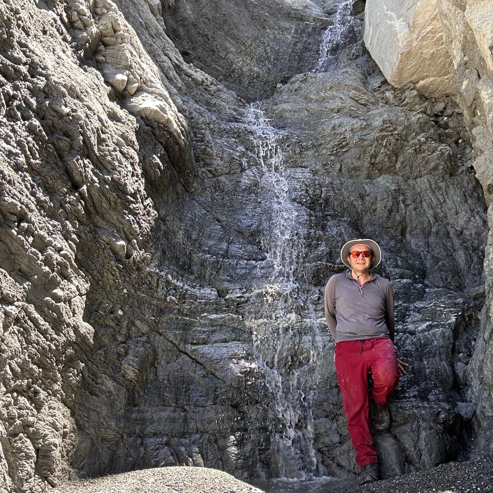
In 2023 tropical storm debris flows revealed the waterfall in my profile picture high in Sheep Canyon; it had been buried in talus. This is likely an even more extreme event.
In 2023 tropical storm debris flows revealed the waterfall in my profile picture high in Sheep Canyon; it had been buried in talus. This is likely an even more extreme event.

December 25, 2025 at 3:33 AM
Sheep Creek is going nuts. Evacuation ORDER from LA County Line to Sheep Creek Rd, from the 18 down to Desert Front Rd.
In 2023 tropical storm debris flows revealed the waterfall in my profile picture high in Sheep Canyon; it had been buried in talus. This is likely an even more extreme event.
In 2023 tropical storm debris flows revealed the waterfall in my profile picture high in Sheep Canyon; it had been buried in talus. This is likely an even more extreme event.
Statement from Mountain High CEO as Wrightwood is under shelter in place order and multiple roads are closed. Crystal Lake hit 8” of rain at 1:30p and Wrightwood had 7” as of 12:30p; it’s likely the area has seen 10” of rain by now. Heavy precipitation should be ending within the hour.


December 24, 2025 at 11:18 PM
Statement from Mountain High CEO as Wrightwood is under shelter in place order and multiple roads are closed. Crystal Lake hit 8” of rain at 1:30p and Wrightwood had 7” as of 12:30p; it’s likely the area has seen 10” of rain by now. Heavy precipitation should be ending within the hour.
If you’re a SoCal skier looking for some hopium, NWS LA’s avalanche guidance for Mountain High (yes that’s a real product they issue) has snow levels crashing to 7500’ this afternoon and 6500’ tomorrow morning with enough QPF to generate some decent snow. BP to Throop above 8000’… fingers crossed.

December 24, 2025 at 8:22 PM
If you’re a SoCal skier looking for some hopium, NWS LA’s avalanche guidance for Mountain High (yes that’s a real product they issue) has snow levels crashing to 7500’ this afternoon and 6500’ tomorrow morning with enough QPF to generate some decent snow. BP to Throop above 8000’… fingers crossed.
Reposted by Transverse Dreams
SR-2 now closed. Parts of Wrightwood may be evacuated due to flooding. --CBS2 at 9:35 a.m.
December 24, 2025 at 5:40 PM
SR-2 now closed. Parts of Wrightwood may be evacuated due to flooding. --CBS2 at 9:35 a.m.
Flash flood warning for Sheep Creek in Wrightwood- this is the center and most rugged of the three prominent landslides above Wrightwood. Likely that all roads crossing it, including the 2, the 138, and the 18 are affected. I saw a massive debris flow here in summer 2023 during the tropical storm.


December 24, 2025 at 5:12 PM
Flash flood warning for Sheep Creek in Wrightwood- this is the center and most rugged of the three prominent landslides above Wrightwood. Likely that all roads crossing it, including the 2, the 138, and the 18 are affected. I saw a massive debris flow here in summer 2023 during the tropical storm.
Mountain High workers out there just making sure the lodge doesn’t flood 😔

December 24, 2025 at 2:53 PM
Mountain High workers out there just making sure the lodge doesn’t flood 😔
Reposted by Transverse Dreams

This was an extraordinary sight today. At Dyersville Bar the main fork and South fork of the Eel River converge. After the storms this week, something close to 150,000 cubic feet per second was flowing by. In the summer the river may have only a few hundred CFS. #floods
December 23, 2025 at 10:03 AM
This was an extraordinary sight today. At Dyersville Bar the main fork and South fork of the Eel River converge. After the storms this week, something close to 150,000 cubic feet per second was flowing by. In the summer the river may have only a few hundred CFS. #floods
Ok there are no weather stations in the San Gabriels over 7000’, so if we want to read some tea leaves… the most recent soundings from San Diego and Vandenberg have freezing level around 10900’ and lapse rates 5C/km. That jives with current temps at Big Pines (7000’, 43F).


December 24, 2025 at 5:05 AM
Ok there are no weather stations in the San Gabriels over 7000’, so if we want to read some tea leaves… the most recent soundings from San Diego and Vandenberg have freezing level around 10900’ and lapse rates 5C/km. That jives with current temps at Big Pines (7000’, 43F).
Reposted by Transverse Dreams
Transverse ranges. Watch out.

December 23, 2025 at 1:38 PM
Transverse ranges. Watch out.
Mountain High holding it together


December 21, 2025 at 7:43 PM
Mountain High holding it together
Huge storm. Dry for a month. Huge storm. The land of extremes.
Despite dry weather over the past month in SoCal, I'm actually more concerned regarding some potentially significant flood risk down south on Wed. A very strong cold front associated w/a very moist atmospheric river will be passing through at this time, w/high rain rates. #CAwx

December 21, 2025 at 7:39 PM
Huge storm. Dry for a month. Huge storm. The land of extremes.