


Andrew Lynch | vanshnookenraggen
@vanshnookenraggen.com
Artist, Cartographer, Historian, Transit Activist.
https://linktr.ee/Vanshnookenraggen
Co-founder of QueensLink @queenslink.org
Opinions are my own.
https://linktr.ee/Vanshnookenraggen
Co-founder of QueensLink @queenslink.org
Opinions are my own.
I've taught you all I know.
January 16, 2026 at 12:51 AM
I've taught you all I know.
Maperitive. You'll have to go through the docs to find out how to do it via the command line. It isn't user friendly, but it works.
maperitive.net
maperitive.net
Maperitive
maperitive.net
January 16, 2026 at 12:35 AM
Maperitive. You'll have to go through the docs to find out how to do it via the command line. It isn't user friendly, but it works.
maperitive.net
maperitive.net
I was using a different program that sourced OSM maps, but this might also work. What I found helpful was to zoom in and export multiple views to build a larger, high res map to trace.
January 15, 2026 at 11:12 PM
I was using a different program that sourced OSM maps, but this might also work. What I found helpful was to zoom in and export multiple views to build a larger, high res map to trace.
But if you want to hand draw it, download a raster image from OSM and trace it.
January 15, 2026 at 10:14 PM
But if you want to hand draw it, download a raster image from OSM and trace it.
The NYC and Boston maps were all hand drawn. But I was able to buy a GIS plug in for Adobe that lets me import large files. So that's sped up the bases of the maps.
January 15, 2026 at 10:11 PM
The NYC and Boston maps were all hand drawn. But I was able to buy a GIS plug in for Adobe that lets me import large files. So that's sped up the bases of the maps.
Well, depends on the map. Which ones are you talking about?
January 15, 2026 at 9:25 PM
Well, depends on the map. Which ones are you talking about?
There's vent space at the top of each tunnel/chamber. You can see it on all of the cross sections. They still needs vents. It's just less space they need to excavate.
January 15, 2026 at 5:56 AM
There's vent space at the top of each tunnel/chamber. You can see it on all of the cross sections. They still needs vents. It's just less space they need to excavate.
At this point, nothing the right does surprises me. They sold their souls for power long ago. I'm more angry at Democrats who think the right is in any way working in good faith.
The right wants pure power at any cost. Any Democrat who can't see this needs to go.
The right wants pure power at any cost. Any Democrat who can't see this needs to go.
January 14, 2026 at 11:03 PM
At this point, nothing the right does surprises me. They sold their souls for power long ago. I'm more angry at Democrats who think the right is in any way working in good faith.
The right wants pure power at any cost. Any Democrat who can't see this needs to go.
The right wants pure power at any cost. Any Democrat who can't see this needs to go.
I'd be curious to see the fire codes of the US and EU side by side to see how they affect station design. This seems to be the main reason (given) for our over-designed stations. Is there flexibility here? Even if there is, my guess is that AECOM doesn't really care.
January 13, 2026 at 11:26 PM
I'd be curious to see the fire codes of the US and EU side by side to see how they affect station design. This seems to be the main reason (given) for our over-designed stations. Is there flexibility here? Even if there is, my guess is that AECOM doesn't really care.
Agnostic, but in a bad way. The tunnel will still be deep because you have more elevation, so you aren't saving any money or time.
January 13, 2026 at 9:04 PM
Agnostic, but in a bad way. The tunnel will still be deep because you have more elevation, so you aren't saving any money or time.
Using the TBMs they have, the park really won't matter. The ground conditions here require a deep bore, which avoids buildings anyways. Climbing up the hill won't save any money or time.
January 13, 2026 at 8:11 PM
Using the TBMs they have, the park really won't matter. The ground conditions here require a deep bore, which avoids buildings anyways. Climbing up the hill won't save any money or time.

Bread and circus, baby
January 12, 2026 at 3:20 AM
Bread and circus, baby
You won. But at what cost?
January 12, 2026 at 12:56 AM
You won. But at what cost?
Reposted by Andrew Lynch | vanshnookenraggen
If normie left-of-centers protestors marched open carry, a standard feature at any right-of-center-plus gathering, federal agents would be behaving quite differently.
January 11, 2026 at 10:03 PM
If normie left-of-centers protestors marched open carry, a standard feature at any right-of-center-plus gathering, federal agents would be behaving quite differently.
It's less of the acting on it, but more of the threat of an armed resistance. Obviously, civil war is bad (hot take), but the Trump Cult seems to be betting that we all won't actually do anything.
January 11, 2026 at 10:01 PM
It's less of the acting on it, but more of the threat of an armed resistance. Obviously, civil war is bad (hot take), but the Trump Cult seems to be betting that we all won't actually do anything.
I've said it before, and I'll say it again: this is why the founding fathers gave us the 2nd Amendment.
January 11, 2026 at 9:38 PM
I've said it before, and I'll say it again: this is why the founding fathers gave us the 2nd Amendment.
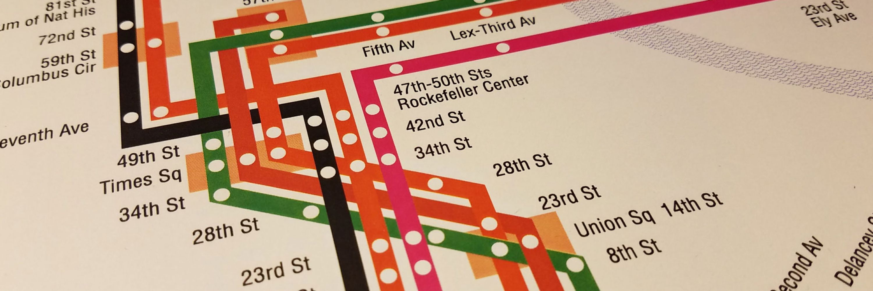
I made this a while ago as a way to "repair" the street grid on Google Maps.

January 7, 2026 at 8:54 AM
I made this a while ago as a way to "repair" the street grid on Google Maps.
7th Ave south of 14th St was also cut through the city grid. Both were done to facilitate new roads that would improve traffic flow.
January 7, 2026 at 8:43 AM
7th Ave south of 14th St was also cut through the city grid. Both were done to facilitate new roads that would improve traffic flow.