Weather History
@weatherhistory.bsky.social
4K followers 2.8K following 1.5K posts
Your daily dose of historical weather and climate events. NWS Meteorologist ~ Scott Doering #weather #history #climate https://sercc.com/weather-history/
Posts Media Videos Starter Packs
weatherhistory.bsky.social
October 8th, 2001:

Hurricane Iris made landfall in Belize as a Category 4. The storm destroyed more than 95% of structures in many villages. A 120-foot scuba diving vessel was capsized with 28 people aboard. Iris killed 36 people and caused $250 million in damages.
weatherhistory.bsky.social
October 7th, 1825:
Raging forest fires in the Miramichi region of New Brunswick, Canada, destroyed over 3 million acres of forest. The blaze has been partly attributed to unusually hot weather in the fall and summer of 1825, coupled with outdoor fires by settlers and loggers.
weatherhistory.bsky.social
October 6th, 2008:

Tropical Storm Marco formed in the Bay of Campeche. This minuscule storm set a world record for the smallest tropical cyclone by radius of winds from the center. At its smallest, tropical storm-force winds extended only 11.5 miles from Marco's core.
Reposted by Weather History
aresel.bsky.social
Pretty surreal to say I’ve officially documented an EF5 tornado. The first EF5 tornado since Moore 2013.

Enderlin, North Dakota - June 20, 2025.
My digital shot of an EF5 tornado near Enderlin, North Dakota on the night of June 20, 2025. My digital shot of an EF5 tornado near Enderlin, North Dakota on the night of June 20, 2025.
Reposted by Weather History
devinwxchase.bsky.social
Wish I had better shots of it, but it looks like it wasn't a Bridge Creek look-a-like just for show after all.
weatherhistory.bsky.social
October 5-6, 2020:

In just 28 hours, Hurricane Delta rapidly intensified from a tropical storm to a 140 mph Category 4. Delta was the third major hurricane and third Category 4 of the year in the Atlantic basin.
weatherhistory.bsky.social
October 5th, 2010:

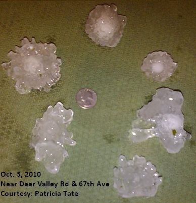
A series of supercells moved through the Phoenix, Arizona, metropolitan area. These severe thunderstorms were prolific hail producers, dropping stones up to 3" in diameter that caused over $2.5 billion in property damage.
weatherhistory.bsky.social
October 4th, 1959:

A morning F3 tore through several communities on the eastern edge of Dallas. Per tornado researcher Thomas Grazulis, "Near-F4 damage was done to homes at many points along the narrow path." A church that was previously destroyed by a tornado in 1947 was hit again.
weatherhistory.bsky.social
October 3rd, 1903:

An estimated F4 tornado moved northeast from west of Chatfield, Minnesota, passing through and devastating St. Charles, Minnesota. Nine people were killed and 45 injured, as 50 homes and businesses were damaged or destroyed.
weatherhistory.bsky.social
October 2nd, 2018:
Twenty-two tornadoes impacted the Northeast. Four twisters were rated EF2, though none were long-lived or deadly. This event was both Pennsylvania's largest October outbreak and one of the state's largest single-day outbreaks in general.
weatherhistory.bsky.social
October 1st, 1890:

The weather service is first identified as a civilian agency when Congress, at the request of President Benjamin Harrison, passes an act transferring the Signal Service’s meteorological responsibilities to the newly created U.S. Weather Bureau in the Department of Agriculture.
Reposted by Weather History
castyman22205.bsky.social
I remember there was talk back in 2016 of Matthew potentially looping back around (like Ivan) but it dissipated before doing that.
NOAA NWS NCEP NHC forecast track for Hurricane Matthew in 2016 with Matthew forecasted at one point to strike Florida twice! 

Source: https://www.nhc.noaa.gov/archive/2016/graphics/al14/loop_5W.shtml CBS 2 New York meteorologist Lonnie Quinn on the possibility of Matthew making a loop (from 2016). 

Source: https://youtu.be/1bdIfyF7dDY?si=oAdGb4d_E7hb8oIX
weatherhistory.bsky.social
September 30-October 1, 2016:

Hurricane Matthew reached Category 5 intensity in the Caribbean Sea north of Colombia. The storm was the first Atlantic Category 5 since Felix in 2007, and also broke the record as the southernmost Category 5 in the Atlantic Ocean.
weatherhistory.bsky.social
September 30th, 2004:

The most active September on record in terms of tornadic activity in the United States came to an end.

Close to 300 tornadoes touched down, most of which were spawned by three separate outbreaks from Hurricanes Frances, Ivan, and Jeanne.
weatherhistory.bsky.social
September 28th, 1998:

Hurricane Georges made a final landfall in Mississippi as a Category 2. The storm brought a massive storm surge, wind gusts over 100 mph, extreme rainfall, major beach erosion, and four dozen tornadoes to the Southeast. Four people were killed.
weatherhistory.bsky.social
September 28th, 1836:
Based on research by David Ludlum, snow fell in parts of Massachusetts, New Hampshire, and New York. The newspaper clippings are from the Library of Congress.
Reposted by Weather History
wisc-satellite.bsky.social
In 1-minute #GOES19/#GOESEast Infrared images, the eye of #Humberto began to exhibit a bit of trochoidal motion as the hurricane further intensified later in the day: cimss.ssec.wisc.edu/satellite-bl...
Reposted by Weather History
castyman22205.bsky.social
Hurricane Gabrielle as a post-tropical cyclone impacting Iberia. She’s a senior now 🥹.

Also see how she connected to a sexy extratropical cyclone via cold front.

Source: NOAA NESDIS STAR, NOAA OAR CIRA CSU, EUMETSAT, Zoom Earth
weatherhistory.bsky.social
September 27th, 1906:
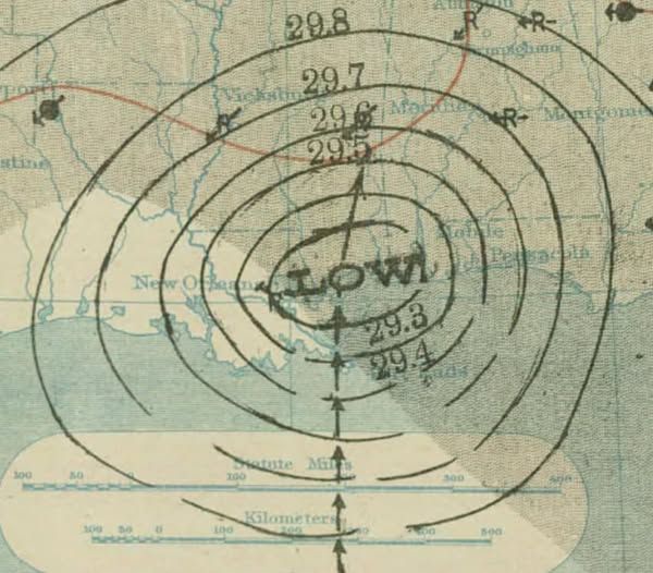
A hurricane made landfall in Mississippi. The storm was estimated to have been a Category 2. Damage was widespread on the Gulf Coast, with at least 130 people losing their lives and more than $19 million (1906 USD) being produced.