UofA Map/GIS Librarian
@wyman10.bsky.social
1.5K followers 420 following 200 posts
William C. Wonders Map Collection, University of Alberta Library. Curation by Wyman Laliberté (he/him) (settler on Treaty 6 land). WCW Map Collection on Internet Archive https://archive.org/details/wcw #spatial #maps #cartography #gis #qgis
Posts Media Videos Starter Packs
wyman10.bsky.social
The John D. and Catherine T. MacArthur Foundation has named Margaret Wickens Pearce, a 2025 MacArthur Fellow. Recognizing her work creating maps that foreground Indigenous peoples’ understanding of land and place and visualize their knowledge, history, and stories. www.clarku.edu/news/2025/10...
Clark alum Margaret Wickens Pearce named 2025 MacArthur Fellow | ClarkU News
Prestigious award celebrates Pearce's cartography recognizing Indigenous legacies
www.clarku.edu
wyman10.bsky.social
In case you missed it, the Map a-day-in May (a thirty-one cabinet display) it is still exhibiting atop the north shore of the 4th floor map cabinets in the Cameron Library.

Biographies and Bibliographies
tinyurl.com/34hn54c3
University of Library News
tinyurl.com/4mjkmyyt
[pano-photo looking south] of Map a-day-in May (a thirty-one cabinet display). Exhibiting atop the north shore of the 4th floor map cabinets in the Cameron Library.  [photo looking west] of Map a-day-in May (a thirty-one cabinet display). Exhibiting atop the north shore of the 4th floor map cabinets in the Cameron Library.
wyman10.bsky.social
The "maps" are on display as you enter the Cameron Library, University of Alberta. www.library.ualberta.ca/locations/ca...
Cameron
www.library.ualberta.ca
wyman10.bsky.social
October is Women’s History Month in Canada, a time to honour the women of our past who carved paths through adversity and opened doors for current and future generations to build a more inclusive and equitable society. This display celebrates Canadian women, past and present. tinyurl.com/yckxszc3
October is Women’s History Month in Canada, a time to honour the remarkable women of our past who carved paths through adversity and opened doors for current and future generations to build a more inclusive and equitable society.
Women’s contributions have too often been overlooked, undervalued, or erased. Yet, in the face of systemic barriers, countless women have persevered, advancing knowledge, and leaving a lasting impact across disciplines. Their achievements stand as powerful testaments to resilience, innovation, and the ongoing pursuit of gender equity in academia and beyond.
This display celebrates the vital role of Canadian women, past and present, in shaping how we understand space and place.
Geospatial information underpins a wide range of disciplines. Through exploration, publishing, artistic expression, Indigenous counter-mapping, and scientific research, these individuals have pushed the boundaries of mapmaking. Their work challenges dominant narratives and deepens spatial awareness, highlighting the diverse and evolving contributions of women to cartography.
This display also features a few contemporary researchers with ties to the University of Alberta, whose work exemplifies the application of geospatial data in academic research and inquiry.

Questions and comments can be directed to Larry Laliberte and Bonnie Gallinger of the William C. Wonders Map Collection data@ualberta.ca
Display on the the left as you enter Cameron Library, University of Alberta. https://www.library.ualberta.ca/locations/cameron

Cartography/Research Illustrations/Indigenous Mapping and Spatial Arts:
Elizabeth Simcoe
Mary Schäffer Warren
Alice E. Wilson
Lillian Wonders
Phoebe Nahanni
Christi Belcourt

Biographies and Bibliographies: https://tinyurl.com/yckxszc3

Display on the the Right as you enter Cameron Library, University of Alberta. https://www.library.ualberta.ca/locations/cameron

Cartography/Research Illustrations/Indigenous Mapping and Spatial Arts:
Margaret Pearce
Katherine Wilson
Heather Gabriel Smith
Alison Criscitiello
Laura Chasmer and Ellen Whitman
Lisa Shepherd and Kristi Bridgemand

Biographies and Bibliographies: https://tinyurl.com/yckxszc3
wyman10.bsky.social
Beginning of Intervention and the First Period of the Civil War. #USSR (Scientific Map Compilation Section - #GUGK) 1959.
#Map 1 & 2 entitled: fevral'-Avgust 1918 g.
Map 2 & 3 entitled: Sentiabr' 1918 g. - fevral' 1919 g.
Inset: Interventsiia na dal'nem vostoke v 1918 g.
archive.org/details/WCWd...
The Beginning of Intervention and the First Period of the Civil War. USSR. Published by Scientific Map Compilation Section - GUGK) in 1959.
Map 1 & 2 entitled: fevral'-Avgust 1918 g.
Map 2 & 3 entitled: Sentiabr' 1918 g. - fevral' 1919 g.
Inset: Interventsiia na dal'nem vostoke v 1918 g. [Inset Map] "Intervention in the East in 1918. From the map  The Beginning of Intervention and the First Period of the Civil War. USSR. Published by Scientific Map Compilation Section - GUGK) in 1959.

Conventional Signs
Left:
-- Area of Actions of the red partisans
-- Retreat of the red partisans to the Taiga 
-- Killing of 9 centro-Siberians by whites

Right:
-- Uprising of the workers of Japan in August 1918 (rice riots)
-- Uprising of military units against the White Guard government Kalmykov in January 1919
-- The intervention of the Entente countries and the Japanese (landers)
wyman10.bsky.social
Denoyer-Geppert social science maps. H29 Growth of Russia.
Compiled and Drawn by R. Baxter Blair
2 col. maps on 1 sheet:
Russia 1462-1914
Russia 1914-1939.
archive.org/details/WCWd...

More #DenoyerGeppertCompany maps/charts via the #DavidRumseyMapCollection
www.davidrumsey.com/luna/servlet...
Denoyer-Geppert social science maps. H29 Growth of Russia.
2 colour maps on 1 sheet: 
Russia 1462 to 1914
Russia 1914 to 1939. [portion] of Denoyer-Geppert social science maps. H29 Growth of Russia. Shows the legends for Russia 1462 to 1914 and Russia 1914 to 1939.
Compiled and Drawn by R. Baxter Blair
2 col. maps on 1 sheet:
wyman10.bsky.social
#companion #cartography
Plano de la Ciudad #Mazatlan Published by Litografia Industria 1930. Negative image from the Zaborski Collection.
archive.org/details/WCWd...

See The City and Port of Mazatlan by Triumph Press, 1965
archive.org/details/WCWd...
Plano de la Ciudad Mazatlan Published by Litografia Industria 1930. A Negative image from the Zaborski Collection.
[portion] of Plano de la Ciudad Mazatlan Published by Litografia Industria 1930. Shows mountain area and city blocks.
wyman10.bsky.social
A patron researching an entomologist who travelled to Mazatlán to research a beetle. Soon they gathered other insects who were drawn to the light outside the hotel door. What was needed was a map from 1960s that showed the city layout and the Sands Hotel where they stayed
archive.org/details/WCWd...
The City and Port of Mazatlan. Published by Triumph Press. 1965. Kym's Guide No. 58. [portion] The City and Port of Mazatlan. Published by Triumph Press. 1965. Kym's Guide No. 58. Showing the location of the Sands Hotel (B2) in 1965. [portion] Map of Mazatlan Sinaloa Mexico. Kym's Guide No. 58. Maps and Charts of Recreation Areas. Published by Triumph Press. 1965. HOTELS... 
HOTEL FREEMAN, along the Avenue of High Waves (Ave- 
nida Olas Altas). Tallest structure in Mazatlan. Air-condi- 
tioned, dining room, a skyroom on the top floor and a 
cocktail lounge. New and modern. 

BELMAR HOTEL, Olas Altas 66. Phone 20-66. Colonial 
atmosphere. Dining room, cocktail lounge. Swimming pool, 
tropical gardens. Air-conditioned. 
ELDORADO HOTEL on Av. del Mar, Phone 30-46. P.O. 
Box 330. Air conditioned rooms have balconies. Restau- 
rant, bar and lounge. Swimming pool. Free parking. 

HOTEL PLAYA MAZATLAN on Las Gaviotas Beach. P.O. 
Box 207. Phone 23-23. A three-story motor hotel. Com- 
fortable rooms and suites. Air conditioned units, 20 pesos 
extra. Air conditioned dining room. Cocktail bar on roof- 
top. Dancing nightly during season. Heated swimming 
pool. Pets allowed. 

HOTEL DE CIMA, Av. del Mar. P.O. Box 350. Phone 34-47. 
Some air-conditioned rooms. Suites. Dining room, air 
conditioned cocktail bar and lounge. Dancing in air- 
conditioned night club. Swimming pool, free parking. 

LIDO HOTEL APARTMENTS, Paseo Clausen and Jaboneria. 
P.O. Box 140. Phone 38-83. Very good housekeeping 
units. Maid service, garage. No pets. Weekly and monthly 
rates. 

HOTEL LA SIESTA, Av. Olas Altos 11, west of the Plaza. 
Phone 26-40. Well managed. Pleasant rooms, some air- 
conditioned, 30 pesos extra. Dining room, cocktails, patio. 
Pets allowed. 

HOSTERIA MENDOZA, Ave. Aleman and Benito Juarez 89, 
near La Paz Ferry Landing. Phone 45-13. Exceptionally 
well kept. Motel-type units with showers. Filtered swim- 
ming pool surrounded by beautiful tropical gardens and 
patio. Specializing in American food, well prepared.  In the central commercial district there are a number of smaller hotels. It is up to the visitor to pick and choose. It is impossible to supply accurate information here for there are so many. 

MOTELS... 
SANDS MOTEL, Avenue del Mar. Phone 47-48. Own beach. Rooms with private balcony. Bar and restaurant, swimming pool.
wyman10.bsky.social
#Westermann #Geography #WallMaps. Distributed by Denoyer-Geppert Company. Catalog GW65. #Publishers, #Importers, #Exporters, Map Mounters. #Maps. #Globes, #Charts, #Atlases, #Models, #Transparencies.
archive.org/details/WCWd...

#Manel #Ashtray #Map
#DenoyerGeppertCompany
Cover of Westermann Geography Wall Maps. Distributed by Denoyer-Geppert Company. Catalog GW65. From page 2 of catalog:

On the front cover we picture an editorial conference ( #Manel ) in the Westermann offices with respect to a new wall map in production. Westermann Geography Wall Maps. Distributed by Denoyer-Geppert Company. Catalog GW65. From page 2 of catalog:

This catalog introduces a new series of large-scale geography wall maps to American schools. The maps are publications of the Georg Westermann Publishing House, one of the world's most important producers of graphic teaching aids. Founded in 1838, Westermann has ranked with the great publishing houses of the world for more than 100 years.

Includes a photo showing the entrance to the Westermann publishing plant in Brunswick (Braunschweig), W. Germany
Includes a wall map price list (insert)

Westermann Geography Wall Maps. Distributed by Denoyer-Geppert Company. Catalog GW65. From page 3 of catalog:

Three photos showing (top to bottom)

A group of cartographers at work. Westermann maps are continuously brought up to data.

An eight color press in operation printing one of many Westermann publications.

Stock room in the Westermann plant, showing printed sheets before they are trimmed and bound into book form.
Westermann Geography Wall Maps. Distributed by Denoyer-Geppert Company. Catalog GW65. From page 2y of catalog:

Has a detailed : DESCRIPTION OF MOUNTINGS

Mountings are designated by code numbers so that it is unnecessary to give a full description of them each time. When ordering, the mounting code number should be written immediately after the catalog number of the map, i.e., GWelrp-14,in which GWelrp designates the map number for the U.S. map and -14 is the mounting code number for a map handmounted on muslin and attached to a spring roller and steel board for mounting on the wall.

Mounting -14. The map is handmounted on durable muslin and attached to a spring roller and steel board. A dustproof cover at the bottom front protects the map when it is rolled up.

Mounting -10. The common roller mounting and perhaps the most popular. The map is mounted on a good grade of muslin. Basswood moldings are fitted top and bottom. The map is hung from metal rings. A tape for tying the map when it is rolled up is also supplied.

Mounting -15. The most durable mounting. Map is handmounted on muslin, attached to a spring roller and inserted into an octagonal steel case for wall mounting, the map rolling face in.

Mounting -1D. The map is cut into sections, generally 9x11", and handmounted on muslin. It is provided with eyelets for hanging and a Fabrikoid cover for protection when folded. When ordering specify folded size desired. It is recommended that large maps should not be cut into a large number of sections.

Mounting -1P. Paper sheets only. Multi-sheet, not trimmed, not mounted on muslin. Price is 40% less than the Mounting -10 price. Sheets are shipped postpaid.

All Westermann wall maps are clothbacked and fitted with mountings by Denoyer-Geppert Company.
wyman10.bsky.social
Instruction pamphlet explaining the details of the ZEISS Standard N2 #Mirror #Stereoscope : Technical data, Technical Hints, Purpose of Instrument, Application, Use, Order Data. archive.org/details/WCWd...

#CarlZeiss en.wikipedia.org/wiki/Carl_Ze...
#ZEISS en.wikipedia.org/wiki/Zeiss_(...
Cover of instruction pamphlet explaining the details of the ZEISS Standard N2 Mirror Stereoscope. Image of two circles containing overlapping air photos. Information on the Application of N 2 Mirror Stereoscope from the instruction pamphlet.

In its basic form, the N2 Mirror Stereoscope is mounted on four removable legs (Fig. 3). The photos, secured to the table with Scotch tape that is adhesive on both sides, are viewed under unity magnification, and if it is desired to have marginal portions more in the center of the field, the entire stereoscope can be shifted, using the legs as handles. A wide range of displacement is provided by the exceptionally large distance between legs.

If the photos are to be viewed under higher magnification, a magnifier attachment can be swung into position (Fig. 4). This attachment has inclined eve pieces allowing the observer to assume a convenient working posture. The magnifier attachment can be hinged back or removed quite simply.

If a completely free working surface is desired under the stereoscope, it is advisable to attach the instru Information on the Technical hints and Order data for the equipment for the N 2 Mirror Stereoscope from the instruction pamphlet.

Order data for the equipment mentioned in this folder

N 2 Mirror Stereoscope with removable legs, in case (as in Fig. 3) 515314

N 2 Mirror Stereoscope with removable legs and magnifier attachment, in case; in addition: supporting arm, photo holder plate with 8 permanent magnets and inclined desk (as in Figs. 5 and 7) 515313

SMM Stereomicrometer with holding bracket, in case (as in Fig. 6) 

L 2 Viewing Desk (as in Fig. 8)

KS Snap Marker in case (as in Fig. 9) 

ES Pointing Instrument in case (as in Fig 9)
wyman10.bsky.social
encourage some ut mappa poesis. A spatial ekphrasis that lyrically describes/depicts the cartographic element, style, and/or process listed for the day (a spatial prose poem expressed in map form on a "Point" or "Line" or "Typography" and even choropleth ect.
wyman10.bsky.social
.. draft display ordering for October 6th, 2025

12 cubes 24"x24" image/collage with 11"x17" information (bios/selected references and related material)

.. reflecting on Nov 2024 Geography Awareness Week "eleven historical windows" display unfolding on map cabinets a week prior tinyurl.com/9jkrj9zj
draft display ordering for 
12 cubes 24"x24" image/collage with 11"x17" information (Bios/Selected References)
Cartographers/Spatial Artists:
Lillian Wonders
Elizabeth Simcoe
Mary Schäffer Warren
Alice E. Wilson
Margaret Pearce (Margaret Wickens)
Phoebe Nahanni
Lisa Shepherd & Kristi Bridgemand
Christi Belcourt
Heather Gabriel Smith
Ellen Whitman
Laura Chasmer 
Katherine Wilson  
Alison Criscitiello
reflecting on Nov 2024 Geography Awareness Week "eleven historical windows" display unfolding on map cabinets a week prior

"Welcome to eleven historical windows. A consumptive past that is still conferring power. These maps, aerials, photos, textual materials, QR codes to online scans and research articles, as well as a magnifying glass have been assembled from the William C. Wonders Map Collection. The maps focus on the Amiskwaciwâskahikan / ᐊᒥᐢᑲᐧᒋᕀᐋᐧᐢᑲᐦᐃᑲᐣ / Edmonton area and beyond covering 5000+ years of history. These kaleido/spatials, drawn from map cabinet drawers, represent natural features like glacial landforms, surficial geology, watersheds, historical heights of land, and the Indigenous and prairie settler geographies embedded in sectional maps, riverlots, and the university of Alberta campus and its relationship to Papaschase.
 https://tinyurl.com/9jkrj9zj Image and QR code for "sedimentations, a thesauri of remains"

Collage: Most collagists draw upon images and textures from the past in their work. This dialogue with the past, indeed, is part of what gives the very medium of collage its power. Centuries of mechanical reproduction have supplied artists with a deep collection of images to engage with. The array of available visual material that has accreted over this timescale is unspeakably vast – a “megacorpus” which is impossible to fully conceptualize. There have been no shortage of curators, however, who have attempted to chart routes via which to approach it. It is our claim that every collage, ultimately, can be seen as an attempt to bind the “fourth dimension” of time into the two-dimensional space of the fine art picture plane – a practice that shares kinship with the cartographer’s struggle to capture three-dimensional space in a two-dimensional medium.

From:  morphic rooms (2023). Passing things i-v (a collage can be a map). you are here the journal of creative geography (Special issue ) 24, Vol. 2023.
wyman10.bsky.social
next display drops Oct 6th…
Maps and bios getting arranged after printing as part of a display starting October 6th.
wyman10.bsky.social
1987 revision of Mundy Map Co. Western Canada #Railway #map tinyurl.com/4kb48jkm originally published in 1955. This explains why the 4 sheets of the Mundy 1955 map were mounted on foam core. So the #cartographer (G.A. Lester) could work off of it. #WCWMC also has a b/w 1923 copy tinyurl.com/4kb48jkm
Western Canada railway map Mundy Map Co. 1955 (Revised 1987)
by G.A. Lester.
B &W map, 66 x 231.5 cm. ozalid reproduction.
Insets: [Lower Mainland of British Columbia]; Extension to Nipigon-Longlac, Ontario; [Edmonton]; [Winnipeg].
Outset: [The rival lines of the Grand Trunk Pacific and the Canadian Northern from the vicinity of Edmonton to Mt. Robson.

Earlier map: Mundy Map Co. Western Canada routing map 1923
https://archive.org/details/WCW_M000425 [pano view] of the original 4 sheets of the 1955 Mundy Map Co. "Western Canada Routing Map. This mounted map is what cartographer G.A. Lester would have worked off of to create their revised 1987 map.  Western Canada routing map by C. G. Mundy; Mundy Map Co. 1923.
https://archive.org/details/WCW_M000425

Shows railway lines and the towns along them in British Columbia, Alberta, and Saskatchewan. Photocopy of a map in the National Map Collection.
wyman10.bsky.social
Not to be outdone by UBC's #Isodemographic #Map of Canada archive.org/details/WCWd... Queen's University, Dept. of Geography (compilation and design by R. Eastman, B. Nelson and G. Shields.) published the Isodemographic Map of North America, 1975-1976 archive.org/details/WCWd...
Isodemographic map of North America, 1975-1976. Published by by Queen's University, Dept. of Geography 1978.

The objective of this map is to portray characteristics of the distribution of population in North America. Through scaling population by area, an attempt has been made to aid in the visualization of relative population sizes. At the same time we have endeavored to preserve, as much as possible, the shapes of urban areas and states (and provinces) as well as contiguity, in order that they be more recognizable.

Compilation and design by Ron Eastman, Gordon Shields, Bill Nelson. Technical assistance R Hough. [portion] Isodemographic map of North America, 1975-1976. Published by by Queen's University, Dept. of Geography 1978.

This map is an illustration of the characteristics of population distribution in North America. Those metropolitan areas depicted have a population of 250,000 or greater as determined from census information current as of 1975-76. Isodemographic maps are scaled in proportion to the number of people they contain. Attempts have been made to preserve the distinctive shapes of most political and geographical units. In order to maintain contiguity between adjacent units, it has been necessary to trade off some attributes of their spatial characteristics, including shape and orientation. As is clearly shown, North American population is highly urbanized, with foci on the Eastern Seaboard, in the Midwest and on the West Coast. Standing out from these established foci are the newer 'growth centers of Atlanta, Houston, Denver, and Toronto. Many metropolitan areas are in reality sections of still larger conurbations. As an example, the New York metropolitan area covers but a small part of what might be called the New York conurbation including much of New Jersey, Connecticut and all of Long Island. The urban/rural split in North America can also be seen from the map. At opposite extremes one might note the Northern Rocky Mountain states with no metropolitan structures, while on the other hand New Jersey is composed almost completely of metropolitan governments. Somewhere in the middle of the spectrum would be the Southern states, with a large rural population and several large, growing urban centers. Canada's ecumene consists of a 200 mile wide belt with numerous cities in the west and east but very low population in between. The primacy of Montreal and Toronto is clearly evident as is the urban hierarchy of southern Ontario. As a demographic portrait, this map has as its main advantage an easily perceived pattern of population in North America.
wyman10.bsky.social
#cartogram classic

#Isodemographic #Map of Canada
archive.org/details/WCWd...

Evident in the pin holes & damaged edges this map was in heavy use through the years.

More info. in the Isodemographic map of Canada #Geographical Paper No. 50 by L. Skoda, & J. C. Robertson
archive.org/details/3176...
Isodemographic Map of Canada.
by University of British Columbia, Canada Department of Fisheries and Forestry, Canada Policy Research and Coordination Branch. Published in 1971.

Shows census division boundaries, census metropolitan areas, selected census major urban areas, selected incorporated cities, and provincial and international boundaries

Based on Dominion Bureau of Statistics 1966 census of Canada.
Areal scale: one square inch represents 60,000 people.
Legend in English and French
Indexed for census divisions

The extreme spatial contrasts in population density in Canada, partly due to the advanced stage of urbanization, make a conventional map an unsuitable base to use in the presentation and analysis of many population characteristics. A map of Canada has therefore been devised in which the areas occupied by census units are proportional to their population. In addition, separate maps of the twelve largest urban centres have been devised which show census tracts in the same manner but at a larger scale.

The necessary transformation of the area and shape of census units was achieved mechanically by means of physical models of Canada and the individual cities in which the populations of the units were represented by appropriate numbers of 1/8” diameter steel ball bearings. The final output, termed an isodemographic map, is a graphical refinement of the physical models to which boundary detail and some topographic features have been added to aid the user.

An Isodemographic map is a type of cartogram in which the size of each area (e.g., country, province, city) is proportional to its population. (Synonym: density-equalizing map)

A cartogram is a map in which the geometry of regions is distorted in order to convey the information of an alternate variable. The region area will be inflated or deflated according to its numeric value. Legend for the Isodemographic Map of Canada.

First Edition. Printed 1971.
Based on Dominion Bureau of Statistics 1966 Census of Canada.
Areal Scale: One Inch Represents 60,000 people

Shows Census Division Boundary, Census Metropolitan Area, Selected Census Major Urban Areas, Selected Incorporated City, International Boundary, Provincial Boundary
Cover of 
Isodemographic map of Canada
Authors: L. Skoda, J. C. Robertson 
Print Book, English, [1972, ©1967]
Publisher: Dept. of the Environment, Lands Directorate, Ottawa, [1972, ©1967]
Physical Description:
viii, 34 pages illustrations, maps (2 folded color in pocket) 28 cm. Page 6 from the Isodemographic map of Canada by L. Skoda, J. C. Robertson. Dept. of the Environment, Lands Directorate, Ottawa, [1972, ©1967]

Page notes: the process of Orthomorphic transformation including Figure 5. Shape deformation principal: a hypothetical situation in which map grid lines designate segments of territory with different populations,
wyman10.bsky.social
cast in a golden light no dress rehearsal - the hip

Métis Trade Routes of the Pacific Northwest (British Columbia) 1806-1886. Lisa Shepherd & Kristi Bridgeman tinyurl.com/rprcz9n3

First Nations Stampede A guide to First Nations history at the Calgary Stampede. Adrian Stimson
tinyurl.com/4ev5aa24
Image of the sun rising through an eastern window illuminating maps on display. First two maps are:

1. Métis Trade Routes of the Pacific Northwest (British Columbia) 1806-1886 by Lisa Shepherd & Kristi Bridgeman.

This map shows the trade routes and historical landing places of Métis people in BC, indicated by “mousetracks” and flower beadwork. Each flower is numbered and the legend tells the name of the related fort or landing place of significant Métis interest. The four directions are indicated in the Michif language. The land geography and its relationship to Métis people, kinship ties and the birth of British Columbia are described. Mixed media: glass beads, porcupine quills, sepia ink, watercolour, stroud. On poster paper (22” x 30”).
https://tinyurl.com/rprcz9n3

2. First Nations Stampede A guide to First Nations history at the Calgary Stampede. (2022). The Calgary Atlas Project. 
The map describes in detail the First Nations participation in the Stampede and the ways that participation changed the nature of the event. It highlights stories from the Calgary Stampede that are not often heard—stories that focus on the sometimes-controversial histories of the Stampede that are an important part of its legacy. 

The artist, Adrian Stimson, a member of the Siksika nation, has mapped the events using Indigenous ways of knowing, using pictographs in spiral and linear arrangements painted on a buffalo robe. The map serves as much to inform and remember as it does to decolonise and reclaim. Researcher: Erin Hryniuk; Artist: Adrian Stimson; Editor: Jim Ellis; Graphic Designer: Glenn Mielke; Photographer: Dave Brown. 
https://tinyurl.com/4ev5aa24


 Image of the sun rising through an eastern window illuminating maps on display in the William C. Wonders Map Library, University of Alberta.
wyman10.bsky.social
morphic rooms (2023). Passing things i-v (a collage can be a map). you are here the journal of creative geography (Special issue ) 24, Vol. 2023.
Collage: Most collagists draw upon images and textures from the past in their work. This dialogue with the past, indeed, is part of what gives the very medium of collage its power. Centuries of mechanical reproduction have supplied artists with a deep collection of images to engage with. The array of available visual material that has accreted over this timescale is unspeakably vast – a “megacorpus” which is impossible to fully conceptualize. There have been no shortage of curators, however, who have attempted to chart routes via which to approach it. It is our claim that every collage, ultimately, can be seen as an attempt to bind the “fourth dimension” of time into the two-dimensional space of the fine art picture plane – a practice that shares kinship with the cartographer’s struggle to capture three-dimensional space in a two-dimensional medium.

morphic rooms (2023). Passing things i-v (a collage can be a map). you are here the journal of creative geography (Special issue ) 24, Vol. 2023.
wyman10.bsky.social
re·read
Maps... are political documents... simultaneously fluid & static. Both artistic & documentary. They are reflections of the relationship between space and identity, of spatiality. Given these characteristics & this complexity, they offer a great deal of conceptual material for an artist.
Barnd, Natchee Blu. (2017). Native space : geographic strategies to unsettle settler colonialism. First Peoples : New Directions in Indigenous Studies Series. Oregon State University Press. 

Native Space explores how Indigenous communities and individuals sustain and create geographies through place-naming, everyday cultural practices, and artistic activism, within the boundaries of the settler colonial nation of the United States. Diverging from scholarship that tends to treat indigenous geography as an analytical concept, Natchee Blu Barnd instead draws attention to the subtle manifestations of everyday cultural practices—the concrete and often mundane activities involved in the creation of Indigenous space.

What are the limits and potentials of Indigenous acts of spatial production? Native Space argues that control over the notion of “Indianness” still sits at the center of how space is produced in a neocolonial nation, and shows how non-Indigenous communities uniquely deploy Native identities in the direct construction of colonial geographies. In short, “the Indian” serves to create White space in concrete ways. Yet, Native geographies effectively reclaim Indigenous identities, assert ongoing relations to the land, and refuse the claims of settler colonialism. 

Barnd creatively and persuasively uses original cartographic research and demographic data, a series of interrelated stories set in the Midwestern Plains states of Kansas and Oklahoma, an examination of visual art by contemporary indigenous artists, and discussions of several forms of indigenous activism to support his argument. With its highly original, interdisciplinary approach, Native Space makes a significant contribution to the literature in cultural and critical geography, comparative ethnic studies, Indigenous studies, cultural studies, American Studies, and related fields.

https://osupress.oregonstate.edu/book/native-space
wyman10.bsky.social
Great map covers, infographics/photos/illustrations via the Lynch Annual Report Collection. ~ 16,000 annual reports of (mostly) Canadian businesses (1935-2011). archive.org/details/larc
The metadata is simple (company name, year, ect.) yet some great finds when searching "search text contents"
over of Devlan Exploration Inc. (2000). Shoreline photo superimposed on a historical map.

https://archive.org/details/Devl4095_2000/

Headquarters: Calgary AB; Former names: Devlan Exploration Company Ltd; McDonald's Corporation (1978)
https://archive.org/details/McDo1250_1978/page/24/mode/2up

Infographic (superposed on a world map) showing (in millions of dollars): 
-- Systemwide sales by quarter
-- Property and equipment, net: Long-term debt
-- Stockholders' equity Bank of Nova Scotia (1979)
https://archive.org/details/Bank2735_1979/page/2/mode/2up?q=map
Map shows Scotiabank around the world
Legend note:
Executive Offices (Black Circle)
Head Office (Orange Circle)
Regional Offices (Blue Circles)
Other Locations (Red Circle)

Also includes a table of Financial and Statistical Highlights (in Millions) for 1979. 
Discovery Mines Limited (1966)
https://archive.org/details/Disc2549_1966/page/22/mode/2up?q=map
Map depicts "Golding Mining in Canada's Far North"
wyman10.bsky.social
#coalfield #colours
#faults mixing #map folds

South Lancashire Coalfield: contour plan of the #Trencherbonie Mine and Ashton Black Mine by George Hickling. Two inches to one mile. October 1924. archive.org/details/WCWd...
South Lancashire Coalfield: contour plan of the Trencherbonie Mine and Ashton Black Mine, by George Hickling. Two inches to one mile
by Lancashire and Cheshire Coal Association 1924. [section] showing faults and map folds 
South Lancashire Coalfield: contour plan of the Trencherbonie Mine and Ashton Black Mine, by George Hickling. Two inches to one mile by Lancashire and Cheshire Coal Association 1924. Index of Colours (measured in feet) 

South Lancashire Coalfield: contour plan of the Trencherbonie Mine and Ashton Black Mine, by George Hickling. Two inches to one mile
by Lancashire and Cheshire Coal Association 1924.
wyman10.bsky.social
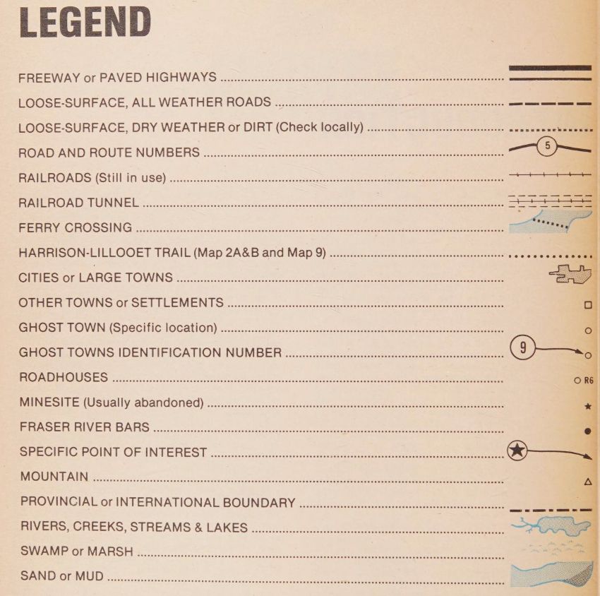
Garnet Basque's "British Columbia ghost town atlas", 1982. Internet Archive (Borrow) tinyurl.com/3c5y366p

B.C. Map 5 notes the Lost Gold Bars Of Camp McKinney
More info by Garnet Basque www.ghosttownsusa.com/bttales7.htm

"Camp McKinney is deserted now. Even the ghosts have gone."
Cover of Legend from Garnet Basque's "British Columbia ghost town atlas", 1982. Available on Internet Archive (Borrow Mode). B.C. Map 5. 1 inch equals 4 miles. Shows location of Camp McKinney's Lost Gold Bars. "Three gold bricks were stolen during a highway robbery in 1896. From Garnet Basque's "British Columbia ghost town atlas", 1982. On IA (Borrow)
wyman10.bsky.social
journaling past..
Graduate Students Dept. of Geography University of Alberta.
"The Albertan geographer" 1965 - 1987.

Not online!

Copyright varies by issue & article. Determined using : Material type: Literary, dramatic/musical work tinyurl.com/sm3weaj7

#Spatial as literary, dramatic & musical!
The complete run (23 vols.) of "The Albertan geographer" 1965 - 1987. Produced by the Graduate Students at the Department of Geography, University of Alberta. The University of Alberta Library as this set in three different locations Offsite (RCRF), Rutherford Humanities Social Sciences, and Education Library and the amazingly deep Canadian Circumpolar Collection (Polar).  

Cover page of Vol. 1 1964/65 of "The Albertan geographer" 1965 - 1987. Produced by the Graduate Students at the Department of Geography, University of Alberta. Previously resided in the Boreal Institute Library You can find more information about the Boreal Institute Library here: https://ualberta.scholaris.ca/items/69027dd2-6d85-4338-acfa-3675a2371e2c

The Boreal Institute for Northern Studies Library: an information centre on the north 
This article describes the 13 year history and functions of the Library at the Boreal Institute for Northern Studies at the University of Alberta. Mrs. Cooke had been the librarian since the library was established. The Boreal Institute Library was one of the North American anchors in the development of the Polar Libraries Colloquy. This article is archived with the permission of Jessica Knoch, President, Library Association of Alberta, 2022. Cover page of Vol. 23 1987 of "The Albertan geographer" 1965 - 1987. Produced by the Graduate Students at the Department of Geography, University of Alberta. Forward by William C. Wonders to vol. 1. "The Albertan geographer" 

Geography as a discipline in Canadian universities is both youthful and vigorous. This is certainly true at the University of Alberta. When I arrived here in 1953 to introduce geography, it posed an immediate administrative problem of where the subject should be placed - and in the minds of some, bewildered by the inability to label the discipline exclusively "Science" or *Social Science," perhaps the problem remains! I understand that the Departments of Geology and of Political Economy both were considered as administrative homes for geography, but eventually the latter won (or lost) out and made us welcome until a separate Department of Geography was established in 1957. Growth of Geography at the University of Alberta has been rapid, even in an era of university expansion...