


UofA Map/GIS Librarian
@wyman10.bsky.social
William C. Wonders Map Collection, University of Alberta Library. Curation by Wyman Laliberté (he/him) (settler on Treaty 6 land).
WCW Map Collection on Internet Archive
https://archive.org/details/wcw
#spatial #maps #cartography #gis #qgis
WCW Map Collection on Internet Archive
https://archive.org/details/wcw
#spatial #maps #cartography #gis #qgis
Deep into woodlands winds a mazy way, reaching to overlapping spurs of mountains bathed in their hill-side blue. But though the map lies tranced, pine-tree shakes down its sighs upon this cartographer's head, yet all were vain, unless the cartographer's eye were fixed upon the stream before them.
![[map portion] Showing Woodland Density. From: Brewer, William H. (1884). Woodland US. United States. Census Office.](https://cdn.bsky.app/img/feed_thumbnail/plain/did:plc:q66r3vy7xepmx62ti4vt7uzb/bafkreibbhrun4umne2q6fzl3hntmxyfm2z4z4qjqziqz37egmfwt436s2u@jpeg)
December 1, 2025 at 3:47 AM
Deep into woodlands winds a mazy way, reaching to overlapping spurs of mountains bathed in their hill-side blue. But though the map lies tranced, pine-tree shakes down its sighs upon this cartographer's head, yet all were vain, unless the cartographer's eye were fixed upon the stream before them.
As every one knows, maps and cartography are wedded for ever. But here is a Cartographer, desiring to map the dreamiest, shadiest, quietest, most enchanting bit of romantic landscape in all the valley of the Saco. There stand trees, here sleeps meadow, up from yonder cottage goes a sleepy smoke.
![[map portion] Showing Saco river. From: Carey, Mathew. (1811). New Hampshire. M. Carey](https://cdn.bsky.app/img/feed_thumbnail/plain/did:plc:q66r3vy7xepmx62ti4vt7uzb/bafkreihpiht6sgo75xfrbjicfbs34dhbkgsvfxrzxixkwau2taswdy4h6e@jpeg)
December 1, 2025 at 3:47 AM
As every one knows, maps and cartography are wedded for ever. But here is a Cartographer, desiring to map the dreamiest, shadiest, quietest, most enchanting bit of romantic landscape in all the valley of the Saco. There stand trees, here sleeps meadow, up from yonder cottage goes a sleepy smoke.
Take any path that carries you down in a dale and leaves you there by a pool in the stream. Let the most absentminded of maps be plunged in deepest reveries, stand that map on it's legs, set it's feet going Should you ever be athirst, your caravan happen to be supplied with a metaphysical cartouche.
![[map portion] Showing Metaphysical Cartouche. From: Willdey, George. (1714). Map projected upon the plane of the horizon. George Willdey](https://cdn.bsky.app/img/feed_thumbnail/plain/did:plc:q66r3vy7xepmx62ti4vt7uzb/bafkreig6ywg53l4fqhqshj7dlnnqvbbsa46bi6r3nurjr7hrqgvut2wq24@jpeg)
December 1, 2025 at 3:47 AM
Take any path that carries you down in a dale and leaves you there by a pool in the stream. Let the most absentminded of maps be plunged in deepest reveries, stand that map on it's legs, set it's feet going Should you ever be athirst, your caravan happen to be supplied with a metaphysical cartouche.
Look! Here come more maps. Noting will content them but the extremest limit of the land; loitering under the shady lee of yonder will not suffice. And there they stand—leagues coming from north, east, south, and west. Does the magnetic virtue of the needles of the compasses attract them thither?
![[map portion] Showing a compass rose. From: The Atlantic Ocean. Laurie & Whittle.](https://cdn.bsky.app/img/feed_thumbnail/plain/did:plc:q66r3vy7xepmx62ti4vt7uzb/bafkreidn46c4js2bjx5msspd4xugm55weystrwaeeidydjeyiljybr25nq@jpeg)
December 1, 2025 at 3:47 AM
Look! Here come more maps. Noting will content them but the extremest limit of the land; loitering under the shady lee of yonder will not suffice. And there they stand—leagues coming from north, east, south, and west. Does the magnetic virtue of the needles of the compasses attract them thither?
Circumambulate the city. What do you see?—Posted like silent sentinels stand thousands of maps. Leaning against the spiles; seated upon the pier-heads; looking over the bulwarks of ships. These are all maps. Tied to counters, nailed to benches, clinched to desks. How then is this? What do they here?
![[map portion] Showing Corlears Hook. From Tanner, Henry S. (1836). New York. H.S. Tanner](https://cdn.bsky.app/img/feed_thumbnail/plain/did:plc:q66r3vy7xepmx62ti4vt7uzb/bafkreibzr76szju27thdeo3wzsxbwu4t3x2jc6hiaugxx4aihdjqbcodqm@jpeg)
![[map portion] Showing Coenties Slip. From: Bourquin, Frederick. (1848). City Of New York. S. Augustus Mitchell.](https://cdn.bsky.app/img/feed_thumbnail/plain/did:plc:q66r3vy7xepmx62ti4vt7uzb/bafkreieikuapfaf2jodggbqsmt6ywxf3i2rknvekqyjg4xpjr53rwf5hdi@jpeg)
December 1, 2025 at 3:47 AM
Circumambulate the city. What do you see?—Posted like silent sentinels stand thousands of maps. Leaning against the spiles; seated upon the pier-heads; looking over the bulwarks of ships. These are all maps. Tied to counters, nailed to benches, clinched to desks. How then is this? What do they here?
Your insular city of the Manhattoes, belted round by wharves as Indian isles by coral reefs—commerce surrounds it with it's surf. The streets take you waterward. Downtown is the battery, where that noble map is washed by waves, and cooled by breezes. Look at the crowds of map-gazers there.
![[portion] Mitchell, Samuel Augustus. (1846). City of New-York. S.A. Mitchell
Melville, Herman. (1930). Moby Dick or The Whale. Illustrated by Rockwell Kent. The Modern Library.](https://cdn.bsky.app/img/feed_thumbnail/plain/did:plc:q66r3vy7xepmx62ti4vt7uzb/bafkreib3uel6adx7zyzweca26zbmez63r3stb2zokmymdrhvbc4qwnoxiq@jpeg)
December 1, 2025 at 3:47 AM
Your insular city of the Manhattoes, belted round by wharves as Indian isles by coral reefs—commerce surrounds it with it's surf. The streets take you waterward. Downtown is the battery, where that noble map is washed by waves, and cooled by breezes. Look at the crowds of map-gazers there.
This mapping is the substitute for pistol and ball. With a philosophical flourish I quietly take to map making. There is nothing surprising in this. If they but knew it, almost all in their degree, some time or other, cherish very nearly the same feelings towards the ocean of cartography.

December 1, 2025 at 3:47 AM
This mapping is the substitute for pistol and ball. With a philosophical flourish I quietly take to map making. There is nothing surprising in this. If they but knew it, almost all in their degree, some time or other, cherish very nearly the same feelings towards the ocean of cartography.
When I find myself growing grim about the mouth; when I find myself pausing before coffin warehouses, and especially when my hypos get an upper hand, that it requires a moral principle to prevent me from stepping into the street, and knocking hats off. Then. I account it high time to get mapping.
![[map portion] Shows Knocking. From: Geological Survey of Great Britain and Ireland. (1883). Great Britain, Ordnance Survey Office.](https://cdn.bsky.app/img/feed_thumbnail/plain/did:plc:q66r3vy7xepmx62ti4vt7uzb/bafkreidivo3uuhluc4pxsf7tl664sxvaewinvebezhvwwblq5f2ckeersy@jpeg)
December 1, 2025 at 3:47 AM
When I find myself growing grim about the mouth; when I find myself pausing before coffin warehouses, and especially when my hypos get an upper hand, that it requires a moral principle to prevent me from stepping into the street, and knocking hats off. Then. I account it high time to get mapping.
Call me Oblique. Having little or no planimetric in my purse, and nothing particular to interest me, I thought I would map the watery part of the world. It is a way I have of driving off the spleen and regulating the circulation. Moby-Dick; or, The [Map] #hermapville
![[modified] Rockwell Kent illustration (Loomings, 1)
[map portion] Geological Survey. (1890). Nantucket sheet. Topographical Survey Commission.
Melville, Herman. (1930). Moby Dick or The Whale. Illustrated by Rockwell Kent. The Modern Library.](https://cdn.bsky.app/img/feed_thumbnail/plain/did:plc:q66r3vy7xepmx62ti4vt7uzb/bafkreiakjclgmu7zzvn4bgacqh2lxju2pwcap7r7gxxg3e2mjbjc4n7ip4@jpeg)
December 1, 2025 at 3:47 AM
Call me Oblique. Having little or no planimetric in my purse, and nothing particular to interest me, I thought I would map the watery part of the world. It is a way I have of driving off the spleen and regulating the circulation. Moby-Dick; or, The [Map] #hermapville
Is there a better collection of Cherubs rocking beyond the neatline? #CherubRock
Taddeo Crivelli / Claudius #Ptolemy (printed c. 1590)
tinyurl.com/3w6bbsnw
Taddeo Crivelli / Claudius #Ptolemy (printed c. 1590)
tinyurl.com/3w6bbsnw


December 1, 2025 at 12:03 AM
Is there a better collection of Cherubs rocking beyond the neatline? #CherubRock
Taddeo Crivelli / Claudius #Ptolemy (printed c. 1590)
tinyurl.com/3w6bbsnw
Taddeo Crivelli / Claudius #Ptolemy (printed c. 1590)
tinyurl.com/3w6bbsnw
EXTRACTS (by a map-map-librarian)
Painstaking burrower and grub-worm of a poor devil. The map librarian appears to have gone through the long street stalls of the earth, picking up whatever random allusions to maps they could find in any book, sacred or profane. Moby-Dick; or, The [MAP] #hermapville
Painstaking burrower and grub-worm of a poor devil. The map librarian appears to have gone through the long street stalls of the earth, picking up whatever random allusions to maps they could find in any book, sacred or profane. Moby-Dick; or, The [MAP] #hermapville
![[modified] Rockwell Kent illustration (Inscribed to Nathaniel Hawthorne)
[portion] Bartlett, J. R. (1884). Pilot chart of the North Atlantic Ocean. December 1884. United States. Naval Oceanographic Office.
Melville, Herman. (1930). Moby Dick or The Whale. Illustrated by Rockwell Kent. The Modern Library.](https://cdn.bsky.app/img/feed_thumbnail/plain/did:plc:q66r3vy7xepmx62ti4vt7uzb/bafkreih7c66sazniubk65qiaeqrmqg2f7aej7hd6rlxwiqnfrtou4d2h2i@jpeg)
November 30, 2025 at 3:30 AM
EXTRACTS (by a map-map-librarian)
Painstaking burrower and grub-worm of a poor devil. The map librarian appears to have gone through the long street stalls of the earth, picking up whatever random allusions to maps they could find in any book, sacred or profane. Moby-Dick; or, The [MAP] #hermapville
Painstaking burrower and grub-worm of a poor devil. The map librarian appears to have gone through the long street stalls of the earth, picking up whatever random allusions to maps they could find in any book, sacred or profane. Moby-Dick; or, The [MAP] #hermapville
ETYMOLOGY.
The pale map—threadbare. The cartographer, ever dusting old lexicons, with a handkerchief, embellished with all the flags of all the known nations of the world. Map makers loved to dust old grammars; it somehow mildly reminded them of their mortality. Moby-Dick; or, THE [MAP] #hermapville
The pale map—threadbare. The cartographer, ever dusting old lexicons, with a handkerchief, embellished with all the flags of all the known nations of the world. Map makers loved to dust old grammars; it somehow mildly reminded them of their mortality. Moby-Dick; or, THE [MAP] #hermapville
![[modified] Rockwell Kent illustration (ETYMOLOGY, xiii)
[portion] Hagelgans, Johann Georg. (1718). Atlas Historicus.
Melville, Herman. (1930). Moby Dick or The Whale. Illustrated by Rockwell Kent. The Modern Library.](https://cdn.bsky.app/img/feed_thumbnail/plain/did:plc:q66r3vy7xepmx62ti4vt7uzb/bafkreic7armflt5tpx352jo76w3jkwbzr5poxkocqqpsvknxomygd7k5lm@jpeg)
November 30, 2025 at 1:51 AM
ETYMOLOGY.
The pale map—threadbare. The cartographer, ever dusting old lexicons, with a handkerchief, embellished with all the flags of all the known nations of the world. Map makers loved to dust old grammars; it somehow mildly reminded them of their mortality. Moby-Dick; or, THE [MAP] #hermapville
The pale map—threadbare. The cartographer, ever dusting old lexicons, with a handkerchief, embellished with all the flags of all the known nations of the world. Map makers loved to dust old grammars; it somehow mildly reminded them of their mortality. Moby-Dick; or, THE [MAP] #hermapville
Image from Henry Everett's 1956 map "The Voyage of the Pequod from the Book Moby Dick by Herman Melville."
tinyurl.com/mvefb4ws
Ismael, buoyed by a coffin-canoe, "floating on a soft and dirgelike [map]." (Epilogue - Moby Dick or The Whale)
The #map, floating, soft, and #dirgelike...
tinyurl.com/mvefb4ws
Ismael, buoyed by a coffin-canoe, "floating on a soft and dirgelike [map]." (Epilogue - Moby Dick or The Whale)
The #map, floating, soft, and #dirgelike...
![[map portion] is from Henry Everett's 1956 map "The Voyage of the Pequod from the Book Moby Dick by Herman Melville.](https://cdn.bsky.app/img/feed_thumbnail/plain/did:plc:q66r3vy7xepmx62ti4vt7uzb/bafkreic7xpe2m6haq3cebjqg6y7nrtax4ov33q4xy624tn2lw6fgzkx3xa@jpeg)
November 21, 2025 at 1:58 PM
Image from Henry Everett's 1956 map "The Voyage of the Pequod from the Book Moby Dick by Herman Melville."
tinyurl.com/mvefb4ws
Ismael, buoyed by a coffin-canoe, "floating on a soft and dirgelike [map]." (Epilogue - Moby Dick or The Whale)
The #map, floating, soft, and #dirgelike...
tinyurl.com/mvefb4ws
Ismael, buoyed by a coffin-canoe, "floating on a soft and dirgelike [map]." (Epilogue - Moby Dick or The Whale)
The #map, floating, soft, and #dirgelike...
reproductions/facsimiles are important artifacts for prairie fringe map collections a mini display for some guests last week #WCWMC
Browse the Theatrum orbis terrarum--corpus of old atlases in facsimile by Theatrum Orbis Terrarum Ltd.
archive.org/details/WCWd...
including a "performative" cover
Browse the Theatrum orbis terrarum--corpus of old atlases in facsimile by Theatrum Orbis Terrarum Ltd.
archive.org/details/WCWd...
including a "performative" cover


November 21, 2025 at 1:30 AM
reproductions/facsimiles are important artifacts for prairie fringe map collections a mini display for some guests last week #WCWMC
Browse the Theatrum orbis terrarum--corpus of old atlases in facsimile by Theatrum Orbis Terrarum Ltd.
archive.org/details/WCWd...
including a "performative" cover
Browse the Theatrum orbis terrarum--corpus of old atlases in facsimile by Theatrum Orbis Terrarum Ltd.
archive.org/details/WCWd...
including a "performative" cover
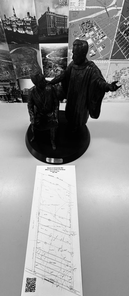
#Terracotta #TrueScale #GISDay and the Visionaries #maquette dropped in for an orientation session.
www.ualberta.ca/en/museums/m...
#RiverLot5 #Treaty6
www.ualberta.ca/en/museums/m...
#RiverLot5 #Treaty6

November 20, 2025 at 1:41 AM
#Terracotta #TrueScale #GISDay and the Visionaries #maquette dropped in for an orientation session.
www.ualberta.ca/en/museums/m...
#RiverLot5 #Treaty6
www.ualberta.ca/en/museums/m...
#RiverLot5 #Treaty6
#30DayMapChallenge Day 19 #Projections
#Hyperboloid projection
milage network scale 1:25,000-1:35,000
Falk-Verlag. (1961) Hamburg.
archive.org/details/hamb...
This map in a Beatle back pocket unfolding in the toppermost of the poppermost days playing clubs along Grosse Freiheit street in Hamburg
#Hyperboloid projection
milage network scale 1:25,000-1:35,000
Falk-Verlag. (1961) Hamburg.
archive.org/details/hamb...
This map in a Beatle back pocket unfolding in the toppermost of the poppermost days playing clubs along Grosse Freiheit street in Hamburg

![[portion] of a map showing Hamburg in 1961. Published by FalkVerlag.
This section and along Grosse Freiheit street was where the Beatles played between 1960-62. One can image this map folded, unfolded, refolded in a Beatle Back pocket.](https://cdn.bsky.app/img/feed_thumbnail/plain/did:plc:q66r3vy7xepmx62ti4vt7uzb/bafkreiaohb3gk3dhtwbq7iadpmvdan27rtm27naq4z2day7zsvuwduakse@jpeg)
November 19, 2025 at 3:00 PM
#30DayMapChallenge Day 19 #Projections
#Hyperboloid projection
milage network scale 1:25,000-1:35,000
Falk-Verlag. (1961) Hamburg.
archive.org/details/hamb...
This map in a Beatle back pocket unfolding in the toppermost of the poppermost days playing clubs along Grosse Freiheit street in Hamburg
#Hyperboloid projection
milage network scale 1:25,000-1:35,000
Falk-Verlag. (1961) Hamburg.
archive.org/details/hamb...
This map in a Beatle back pocket unfolding in the toppermost of the poppermost days playing clubs along Grosse Freiheit street in Hamburg
#30DayMapChallenge Day 13 10 min. Map
Pre 1900 Trail Network
Along the North Saskatchewan River
With a wisp of a north arrow from
Plan d’ une Partie de la Riviere Rouge - North Sheet (1871)
www.flickr.com/photos/manit...
Pre 1900 Trail Network
Along the North Saskatchewan River
With a wisp of a north arrow from
Plan d’ une Partie de la Riviere Rouge - North Sheet (1871)
www.flickr.com/photos/manit...

November 13, 2025 at 4:29 PM
#30DayMapChallenge Day 13 10 min. Map
Pre 1900 Trail Network
Along the North Saskatchewan River
With a wisp of a north arrow from
Plan d’ une Partie de la Riviere Rouge - North Sheet (1871)
www.flickr.com/photos/manit...
Pre 1900 Trail Network
Along the North Saskatchewan River
With a wisp of a north arrow from
Plan d’ une Partie de la Riviere Rouge - North Sheet (1871)
www.flickr.com/photos/manit...
A request for historical maps of the Edmonton River Valley turned up this 1978 Capital City Recreation Park brochure (tabloid size!) archive.org/details/WCWd...
Lots of interesting planning and river valley history (Water Quality, Bank Stabilization, and the infamous Strathcona Science Park, ect.)
Lots of interesting planning and river valley history (Water Quality, Bank Stabilization, and the infamous Strathcona Science Park, ect.)
![Cover of the 1978 Capital City Recreation Park [publicity brochure]
Notes:
It was to provide improved recreational opportunities for all Edmontonians, as well as to upgrade river facilities before the 1978 Commonwealth Games, that the Alberta government decided to provide about $34 million for a parks development in the river valley of east Edmonton.
Most of the planning and development for this river area, now known as the Capital City Recreation Park, is complete. It complements the city’s 1970 master plan for parks development and provides funds for trails, landscaping, shoreline stabilization, public use amenities, a science centre, four pedestrian bridges, fresh water lagoons, and property acquisition within two narrow strips on both banks of the North Saskatchewan River.
The vision, to provide a recreation playground in the river heart of a rapidly growing and modern city, is not a new one. As early as 1907, the city council of that era entertained a report by Frederick G. Todd, a landscape architect from Montreal, that designed a plan for parks and boulevards in Edmonton. It recommended ... “every advantage should be taken of the great natural beauty of the situation . . . by withdrawing for parks purposes, property, such as the river valley and ravines.”
Mr. Todd’s recommendation for a river valley park system was accepted and adopted into the 1915 city plan. In 1933, the city zoned much of the area for use as a “public park”, introducing land use regulations to that effect.
A further report, the Bland-Spence Sales Report, was adopted in principle by city council in 1949. It recommended a “comprehensive system of parkways’’ throughout the whole river valley and proposed a system by which development in the river valley could be opposed. This was first implemented in 1951 when council approved a plan showing Rossdale Flats as proposed parkland.](https://cdn.bsky.app/img/feed_thumbnail/plain/did:plc:q66r3vy7xepmx62ti4vt7uzb/bafkreif3cllvypbypq6kh2sb6vpkwiha2nugkyaedjwassirfxdmdwd6jm@jpeg)
![[map] Overall Plan, Trails and Improvements in the 1978 Capital City Recreation Park
Shows:
RESTRICTED DEVELOPMENT AREA
WATER CONSERVATION AREA
BIKEPATH
HIKING TRAIL
FOOTBRIDGE
UNDERPASS
TOEBERM
AMENITIES STRUCTURES AND PARK BUILDINGS
PARKING LOTS](https://cdn.bsky.app/img/feed_thumbnail/plain/did:plc:q66r3vy7xepmx62ti4vt7uzb/bafkreicwzbxgunuxag5fjiul6b3ubjkgiondg2tcp3nigqehxpkbkhh5ku@jpeg)
![From the 1978 Capital City Recreation Park [publicity brochure]
Capital City Recreational Park Opening Day Activities, July 9, 1978.](https://cdn.bsky.app/img/feed_thumbnail/plain/did:plc:q66r3vy7xepmx62ti4vt7uzb/bafkreib2niif7jy3ivq5eaogk4nzh7qztkntulvkwzymbp7gjmrm2uqguy@jpeg)
![From the 1978 Capital City Recreation Park [publicity brochure]
Strathcona Science Park forms the most easterly node of the Capital City Recreation Park plan, and will provide a dynamic new provincial educational and cultural facility in a beautifully landscaped provincial park.
Strathcona Science Park is located on the eastern side of the North Saskatchewan River in the County of Strathcona, adjacent to the eastern gateway to the city. at Highway No. 16. The Strathcona site is about 2 kilometres in length and up to 1,500 metres in width. It comprises a high plateau with steep slopes dropping down to the river, affording commanding views of the river valley, downtown Edmonton and petrochemical industries nearby.
The 350-acre site is a key element in the Capital City Recreation Park plan, providing for rehabilitation and beautification of a derelict site ringed by industry, which otherwise might adversely affect the Capital City Park concept.
The planning of the park has been the responsibility of the Science Centre Committee, with Raymond Harrison, MRAIC, as the programming and development consultant. The concept of a river valley park fringing an industrial area is not only noteworthy in itself, but it provides a relevant setting for a natural resource science interpretive centre. As the first major cultural facility on the eastern side of Edmonton, it provides a balance to the museums and the historical and cultural attractions located in the western part.
When fully developed, the south end of Strathcona Science Park will feature a nature interpretive area in the ravine and an extensive picnic area with well developed viewpoints.
The Strathcona Science Park is being developed as a vital public educational institution in popular science and technology, for the purpose of enabling Albertans to better understand the rapid and complex changes taking place now and in the future.](https://cdn.bsky.app/img/feed_thumbnail/plain/did:plc:q66r3vy7xepmx62ti4vt7uzb/bafkreie353qgtbebelo5qbgiphz2iasurwwod2mmt7mpk65unf6lavzc3a@jpeg)
November 12, 2025 at 11:43 PM
A request for historical maps of the Edmonton River Valley turned up this 1978 Capital City Recreation Park brochure (tabloid size!) archive.org/details/WCWd...
Lots of interesting planning and river valley history (Water Quality, Bank Stabilization, and the infamous Strathcona Science Park, ect.)
Lots of interesting planning and river valley history (Water Quality, Bank Stabilization, and the infamous Strathcona Science Park, ect.)
... remaining cabinet clusters still holding their soldered edges in the #archaeosphere
November 12, 2025 at 4:34 PM
... remaining cabinet clusters still holding their soldered edges in the #archaeosphere
#30DayMapChallenge Day 12 #Map2125
After the "the burning of the transom lockers" or the purge of archives 2038-40. Only wrack lined linen backed spatial fragments survived. Along with some...
After the "the burning of the transom lockers" or the purge of archives 2038-40. Only wrack lined linen backed spatial fragments survived. Along with some...
![[section] Plan showing the region explored by S. J. Dawson and his party between Fort William, Lake Superior and the Great Saskatchewan River from 1st of August 1857, to 1st November 1858. [linen backed)
Printed in Toronto by John Lovell.
To accompany Report on the Exploration of the country between Lake Superior and the Red River Settlement and between the latter place and the Assiniboine and Saskatchewan, by S. J. Dawson.
https://archive.org/details/reportonexplorat00unse/page/24/mode/2up](https://cdn.bsky.app/img/feed_thumbnail/plain/did:plc:q66r3vy7xepmx62ti4vt7uzb/bafkreihuqduewdfoqazquekjes33oihamodrcweqrg4wl2vgonmloi5bva@jpeg)
November 12, 2025 at 4:34 PM
#30DayMapChallenge Day 12 #Map2125
After the "the burning of the transom lockers" or the purge of archives 2038-40. Only wrack lined linen backed spatial fragments survived. Along with some...
After the "the burning of the transom lockers" or the purge of archives 2038-40. Only wrack lined linen backed spatial fragments survived. Along with some...
The maps overflow area or The Elevator Room (ER) needs to be cleared (like the Canadian Circumpolar Collection) to make room for a renovation on the fourth floor. To accommodate ever changing office space requirements.
1st image ER on November 5th, 2025
2nd image ER on November 10th, 2025
1st image ER on November 5th, 2025
2nd image ER on November 10th, 2025


November 12, 2025 at 4:00 AM
The maps overflow area or The Elevator Room (ER) needs to be cleared (like the Canadian Circumpolar Collection) to make room for a renovation on the fourth floor. To accommodate ever changing office space requirements.
1st image ER on November 5th, 2025
2nd image ER on November 10th, 2025
1st image ER on November 5th, 2025
2nd image ER on November 10th, 2025
Wall maps move again.
10 years ago they went from the old offsite storage "The BARD" (2nd pic) back to the library in the overflow storage area or The Elevator Room.
The richest appreciation one can have of a [wall map] is to know what prompted that conscious decision to put it there. (Ed Dahl)
10 years ago they went from the old offsite storage "The BARD" (2nd pic) back to the library in the overflow storage area or The Elevator Room.
The richest appreciation one can have of a [wall map] is to know what prompted that conscious decision to put it there. (Ed Dahl)


November 12, 2025 at 4:00 AM
Wall maps move again.
10 years ago they went from the old offsite storage "The BARD" (2nd pic) back to the library in the overflow storage area or The Elevator Room.
The richest appreciation one can have of a [wall map] is to know what prompted that conscious decision to put it there. (Ed Dahl)
10 years ago they went from the old offsite storage "The BARD" (2nd pic) back to the library in the overflow storage area or The Elevator Room.
The richest appreciation one can have of a [wall map] is to know what prompted that conscious decision to put it there. (Ed Dahl)
#30DayMapChallenge Day 11 #MinimalMap
2 #Maps + 1 #LightTable
General map Routes in British North America explored by Captain Palliser 1967-60 #Mylar
Economic Geology [1:250000]. 1894 Geological Atlas of the US Livingston Folio, Montana #Paper
Hamilton Light Table #Light
2 #Maps + 1 #LightTable
General map Routes in British North America explored by Captain Palliser 1967-60 #Mylar
Economic Geology [1:250000]. 1894 Geological Atlas of the US Livingston Folio, Montana #Paper
Hamilton Light Table #Light
![#30DayMapChallenge Day 11 #MinimalMap
2 #Maps + 1 #LightTable
General map of the routes in British North America explored by the expedition under Captain Palliser during the years 1857, 1858, 1859, 1860 - compiled from the Observations and Reports of Captain Palliser and his Officers, including the Maps constructed by Dr. Hector, and other authentic documents #Mylar
https://archive.org/details/WCW_M000367/
Economic Geology [1:250000]. 1894 Geological Atlas of the US Livingston Folio, Montana #Paper
Hamilton Light Table #Light](https://cdn.bsky.app/img/feed_thumbnail/plain/did:plc:q66r3vy7xepmx62ti4vt7uzb/bafkreibytpplkf22lxpueo6wxhp3tgswtkk5kos6b2nnliufl3icd37yoy@jpeg)
![[Cover]
Department of the Interior United States Geological Survey
J.W. Powell, Director
Geologic Atlas of the United States
Livingston Folio, Montana
Scale: 40 Miles -1 Inch
List of Sheets: Description, Topography, Areal Geology, Economic Geology, Structure Sections, Columnar Sections
Field Edition
Washington, D.C.
Engraved and Printed by the U.S. Geological Survey
Bailey Willis, Editor of Geologic Maps S.J. Kübel, Chief Engraver
1894](https://cdn.bsky.app/img/feed_thumbnail/plain/did:plc:q66r3vy7xepmx62ti4vt7uzb/bafkreig5ydykxcc5sqpihtk4vlk5qjocfrr6ftuscqdgnvbgehecizacjy@jpeg)
![[map]
Economic Geology
Montana, Livingston Sheet
Scale [1:250000]
Contour Interval 200 feet
Edition of July 1893
Surveyed in 1886-87](https://cdn.bsky.app/img/feed_thumbnail/plain/did:plc:q66r3vy7xepmx62ti4vt7uzb/bafkreia7u5mhuiypr5lcd4yx4m7x6mj5myoeccstg3o7ymgqoa4klzhqfe@jpeg)
![[section of map]
General map of the routes in British North America explored by the expedition under Captain Palliser during the years 1857, 1858, 1859, 1860 - compiled from the Observations and Reports of Captain Palliser and his Officers, including the Maps constructed by Dr. Hector, and other authentic documents. By John Palliser, British North American Exploring Expedition
https://archive.org/details/WCW_M000367/](https://cdn.bsky.app/img/feed_thumbnail/plain/did:plc:q66r3vy7xepmx62ti4vt7uzb/bafkreiafsunlq4j4haexzugk3bsyut7tuxmm4anqhokstgxcqp36pnfbs4@jpeg)
November 11, 2025 at 4:48 PM
#30DayMapChallenge Day 11 #MinimalMap
2 #Maps + 1 #LightTable
General map Routes in British North America explored by Captain Palliser 1967-60 #Mylar
Economic Geology [1:250000]. 1894 Geological Atlas of the US Livingston Folio, Montana #Paper
Hamilton Light Table #Light
2 #Maps + 1 #LightTable
General map Routes in British North America explored by Captain Palliser 1967-60 #Mylar
Economic Geology [1:250000]. 1894 Geological Atlas of the US Livingston Folio, Montana #Paper
Hamilton Light Table #Light
#30DayMapChallenge Day 10 #AirTraffic
Scandinavian Airlines System (SAS) 1956
10 maps showing #SAS air traffic routes.
Great #PubNotes Just scroll down past the AI summaries (which should be treated as provisional and verified against primary sources) tinyurl.com/2ppcfbuu #DavidRumseyMapCollection
Scandinavian Airlines System (SAS) 1956
10 maps showing #SAS air traffic routes.
Great #PubNotes Just scroll down past the AI summaries (which should be treated as provisional and verified against primary sources) tinyurl.com/2ppcfbuu #DavidRumseyMapCollection


November 10, 2025 at 5:12 PM
#30DayMapChallenge Day 10 #AirTraffic
Scandinavian Airlines System (SAS) 1956
10 maps showing #SAS air traffic routes.
Great #PubNotes Just scroll down past the AI summaries (which should be treated as provisional and verified against primary sources) tinyurl.com/2ppcfbuu #DavidRumseyMapCollection
Scandinavian Airlines System (SAS) 1956
10 maps showing #SAS air traffic routes.
Great #PubNotes Just scroll down past the AI summaries (which should be treated as provisional and verified against primary sources) tinyurl.com/2ppcfbuu #DavidRumseyMapCollection
Day 5 #30DayMapChallenge - #Earth
The U.S. Ex. Ex.) of 1838–1842
Fig. 1. USS Peacock in Contact with the Ice.
www.davidrumsey.com/luna/servlet...
Chart of the Antarctic Continent. 1840
www.davidrumsey.com/luna/servlet...
#WhiteWall #WhiteWhale
The U.S. Ex. Ex.) of 1838–1842
Fig. 1. USS Peacock in Contact with the Ice.
www.davidrumsey.com/luna/servlet...
Chart of the Antarctic Continent. 1840
www.davidrumsey.com/luna/servlet...
#WhiteWall #WhiteWhale
![Fig. 1. USS Peacock in Contact with the Ice. Alfred Thomas Agate. NUSEE Vol. 2. Facing page 318. Public Domain.
[image] Peacock in contact with ice-berg. A.T. Agate pt. M. Osborne sc. (Philadelphia: Lea & Blanchard. 1845).
According (Grunes 2021) it is through expedition leader Charles Wilkes, Melville explores the nonhuman sublime, its power to test human physical and epistemological limits, and the driving ambition it provokes. In the process, Melville extends Wilkes’s image of the “icy barrier” around Antarctica. This wall, barrier, or mask becomes an origin point for the ambitions—Ahabian, Ishmaelian, Wilkesian and even Melvillian—that energize epic endeavors, including those of the young republic’s nascent expansionist imperialism.
Grunes, M. (2021). Ahab and Ishmael in Antarctica: How Charles Wilkes’s White Continent Gave Rise to the White Whale. Leviathan (Hempstead, N.Y.), 23(2), 3–33. https://doi.org/10.1353/lvn.2021.0013](https://cdn.bsky.app/img/feed_thumbnail/plain/did:plc:q66r3vy7xepmx62ti4vt7uzb/bafkreiedgzf5sdjqtzddohhcmvxzeay26csa3flvhbacq6x7637b2sz3b4@jpeg)
![[portion] of Chart of the Antarctic Continent. 1840. Showing "Line of Icy Barrier"
"To Americans, Antarctic exploration offered possibilities for economic expansion as well as the less tangible prize of international glory. This fascination culminated in the discovery of the Antarctic continent in 1840 by the United States Exploring Expedition (or U.S. Ex. Ex.), commanded by the relentlessly ambitious Navy Lieutenant Charles Wilkes. When Wilkes led his ships south, it was unknown whether ice, land, or open ocean covered the South Pole. Within only a few weeks, the expedition had identified the existence of the continent; yet Wilkes had an even grander goal in mind: to land on the continent. For nearly two bitter months, his men mapped 1,500 miles of the coastline, seeking an opening in the icy barrier girding the continent. They never set foot on it."
From - Grunes, M. (2021). Ahab and Ishmael in Antarctica: How Charles Wilkes’s White Continent Gave Rise to the White Whale. Leviathan (Hempstead, N.Y.), 23(2), 3–33. https://doi.org/10.1353/lvn.2021.0013](https://cdn.bsky.app/img/feed_thumbnail/plain/did:plc:q66r3vy7xepmx62ti4vt7uzb/bafkreidagfqbbeu7s4ocem756epfynzcjvmkzqi4erxyzjg4zb5qbcuu2a@jpeg)

November 5, 2025 at 10:23 PM
Day 5 #30DayMapChallenge - #Earth
The U.S. Ex. Ex.) of 1838–1842
Fig. 1. USS Peacock in Contact with the Ice.
www.davidrumsey.com/luna/servlet...
Chart of the Antarctic Continent. 1840
www.davidrumsey.com/luna/servlet...
#WhiteWall #WhiteWhale
The U.S. Ex. Ex.) of 1838–1842
Fig. 1. USS Peacock in Contact with the Ice.
www.davidrumsey.com/luna/servlet...
Chart of the Antarctic Continent. 1840
www.davidrumsey.com/luna/servlet...
#WhiteWall #WhiteWhale