4 ENE Colfax [Grant Co, LA] Law Enforcement reports Tstm Wnd Dmg at 14 Feb, 8:50 PM CST -- Tree reported downed on Cold Branch Road to tbe east of Colfax.
at Sun, 15 Feb 2026 04:13:59 +0000 via IEMbot
Additional Details Here.
at Sun, 15 Feb 2026 04:13:59 +0000 via IEMbot
Additional Details Here.
February 15, 2026 at 4:27 AM
4 ENE Colfax [Grant Co, LA] Law Enforcement reports Tstm Wnd Dmg at 14 Feb, 8:50 PM CST -- Tree reported downed on Cold Branch Road to tbe east of Colfax.
at Sun, 15 Feb 2026 04:13:59 +0000 via IEMbot
Additional Details Here.
at Sun, 15 Feb 2026 04:13:59 +0000 via IEMbot
Additional Details Here.

At 8:50 PM CST, 4 ENE Colfax [Grant Co, LA] Law Enforcement reports Tstm Wnd Dmg. Tree reported downed on Cold Branch Road to tbe east of Colfax. #lawx Link

February 15, 2026 at 4:14 AM
At 8:50 PM CST, 4 ENE Colfax [Grant Co, LA] Law Enforcement reports Tstm Wnd Dmg. Tree reported downed on Cold Branch Road to tbe east of Colfax. #lawx Link

#nws #tornado Tornado Warning for Grant, LA #lawx
At 907 PM CST, a severe thunderstorm capable of producing a tornado
was located 15 miles east of Colfax, or 34 miles south of Winnfield,
moving east at 35 mph.
HAZARD...Tornado.
SOURCE...Radar indicated rotation […]
[Original post on ai6yr.org]
At 907 PM CST, a severe thunderstorm capable of producing a tornado
was located 15 miles east of Colfax, or 34 miles south of Winnfield,
moving east at 35 mph.
HAZARD...Tornado.
SOURCE...Radar indicated rotation […]
[Original post on ai6yr.org]

February 15, 2026 at 3:16 AM
#nws #tornado Tornado Warning for Grant, LA #lawx
At 907 PM CST, a severe thunderstorm capable of producing a tornado
was located 15 miles east of Colfax, or 34 miles south of Winnfield,
moving east at 35 mph.
HAZARD...Tornado.
SOURCE...Radar indicated rotation […]
[Original post on ai6yr.org]
At 907 PM CST, a severe thunderstorm capable of producing a tornado
was located 15 miles east of Colfax, or 34 miles south of Winnfield,
moving east at 35 mph.
HAZARD...Tornado.
SOURCE...Radar indicated rotation […]
[Original post on ai6yr.org]
🚨 Tornado Watch issued February 14 at 9:02PM CST until February 15 at 2:00AM CST by NWS Shreveport LA 🚨
Additional Details Here.
Additional Details Here.

February 15, 2026 at 3:15 AM
🚨 Tornado Watch issued February 14 at 9:02PM CST until February 15 at 2:00AM CST by NWS Shreveport LA 🚨
Additional Details Here.
Additional Details Here.
🚨 Tornado Warning issued February 14 at 9:07PM CST until February 14 at 9:30PM CST by NWS Shreveport LA 🚨
Additional Details Here.
Additional Details Here.

February 15, 2026 at 3:15 AM
🚨 Tornado Warning issued February 14 at 9:07PM CST until February 14 at 9:30PM CST by NWS Shreveport LA 🚨
Additional Details Here.
Additional Details Here.
🚨 Severe Thunderstorm Warning issued February 14 at 9:01PM CST until February 14 at 9:45PM CST by NWS Shreveport LA 🚨
Additional Details Here.
Additional Details Here.

February 15, 2026 at 3:15 AM
🚨 Severe Thunderstorm Warning issued February 14 at 9:01PM CST until February 14 at 9:45PM CST by NWS Shreveport LA 🚨
Additional Details Here.
Additional Details Here.

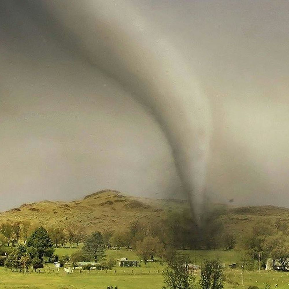
Grant, LA: At 907 PM CST, a severe thunderstorm capable of producing a tornado was located 15 miles east of Colfax, or 34 miles south of Winnfield, moving east at 35 mph..
February 15, 2026 at 3:08 AM
Grant, LA: At 907 PM CST, a severe thunderstorm capable of producing a tornado was located 15 miles east of Colfax, or 34 miles south of Winnfield, moving east at 35 mph..
#nws #tornado Tornado Warning for Grant, LA #lawx
At 853 PM CST, a severe thunderstorm capable of producing a tornado
was located 8 miles southeast of Colfax, or 33 miles south of
Winnfield, moving east at 35 mph.
HAZARD...Tornado.
SOURCE...Radar indicated […]
[Original post on ai6yr.org]
At 853 PM CST, a severe thunderstorm capable of producing a tornado
was located 8 miles southeast of Colfax, or 33 miles south of
Winnfield, moving east at 35 mph.
HAZARD...Tornado.
SOURCE...Radar indicated […]
[Original post on ai6yr.org]

February 15, 2026 at 3:08 AM
#nws #tornado Tornado Warning for Grant, LA #lawx
At 853 PM CST, a severe thunderstorm capable of producing a tornado
was located 8 miles southeast of Colfax, or 33 miles south of
Winnfield, moving east at 35 mph.
HAZARD...Tornado.
SOURCE...Radar indicated […]
[Original post on ai6yr.org]
At 853 PM CST, a severe thunderstorm capable of producing a tornado
was located 8 miles southeast of Colfax, or 33 miles south of
Winnfield, moving east at 35 mph.
HAZARD...Tornado.
SOURCE...Radar indicated […]
[Original post on ai6yr.org]

🚨 Tornado Warning issued February 14 at 8:53PM CST until February 14 at 9:30PM CST by NWS Shreveport LA 🚨
Additional Details Here.
Additional Details Here.

February 15, 2026 at 3:00 AM
🚨 Tornado Warning issued February 14 at 8:53PM CST until February 14 at 9:30PM CST by NWS Shreveport LA 🚨
Additional Details Here.
Additional Details Here.
🚨 Severe Thunderstorm Warning issued February 14 at 8:52PM CST until February 14 at 9:45PM CST by NWS Shreveport LA 🚨
Additional Details Here.
Additional Details Here.

February 15, 2026 at 3:00 AM
🚨 Severe Thunderstorm Warning issued February 14 at 8:52PM CST until February 14 at 9:45PM CST by NWS Shreveport LA 🚨
Additional Details Here.
Additional Details Here.
Grant, LA: At 853 PM CST, a severe thunderstorm capable of producing a tornado was located 8 miles southeast of Colfax, or 33 miles south of Winnfield, moving east at 35 mph..
February 15, 2026 at 2:54 AM
Grant, LA: At 853 PM CST, a severe thunderstorm capable of producing a tornado was located 8 miles southeast of Colfax, or 33 miles south of Winnfield, moving east at 35 mph..
Grant, LA: At 845 PM CST, a severe thunderstorm capable of producing a tornado was located 6 miles south of Colfax, or 32 miles southeast of Natchitoches, moving east at 35 mph.. NWS: TORNADO WARNING in this area til 9:30 PM CST. Take shelter now. Check media.
February 15, 2026 at 2:46 AM
Grant, LA: At 845 PM CST, a severe thunderstorm capable of producing a tornado was located 6 miles south of Colfax, or 32 miles southeast of Natchitoches, moving east at 35 mph.. NWS: TORNADO WARNING in this area til 9:30 PM CST. Take shelter now. Check media.
🚨 Severe Thunderstorm Warning issued February 14 at 8:29PM CST until February 14 at 9:00PM CST by NWS Shreveport LA 🚨
Additional Details Here.
Additional Details Here.

February 15, 2026 at 2:30 AM
🚨 Severe Thunderstorm Warning issued February 14 at 8:29PM CST until February 14 at 9:00PM CST by NWS Shreveport LA 🚨
Additional Details Here.
Additional Details Here.
🚨 Severe Thunderstorm Warning issued February 14 at 8:09PM CST until February 14 at 9:00PM CST by NWS Shreveport LA 🚨
Additional Details Here.
Additional Details Here.

February 15, 2026 at 2:15 AM
🚨 Severe Thunderstorm Warning issued February 14 at 8:09PM CST until February 14 at 9:00PM CST by NWS Shreveport LA 🚨
Additional Details Here.
Additional Details Here.
🚨🚨🚨 Tornado Watch issued February 14 at 7:44PM CST until February 15 at 2:00AM CST by NWS Shreveport LA 🚨🚨🚨
Additional Details Here.
Additional Details Here.


February 15, 2026 at 1:45 AM
🚨🚨🚨 Tornado Watch issued February 14 at 7:44PM CST until February 15 at 2:00AM CST by NWS Shreveport LA 🚨🚨🚨
Additional Details Here.
Additional Details Here.

The unsightly white station arches springing up along the middle of the road aren’t much cause for comfort, but at least a few of those arches will become public works of art.
https://www.westword.com/arts-culture/can-a-2-2-million-art-project-make-brt-colfax-arches-less-ugly-40842775/
https://www.westword.com/arts-culture/can-a-2-2-million-art-project-make-brt-colfax-arches-less-ugly-40842775/

Can a $2.2 Million Art Project Make BRT's Colfax Arches Less Ugly?
Dozens of the new BRT station arches along Colfax Avenue will become public works of art.
www.westword.com
February 14, 2026 at 5:01 PM
The unsightly white station arches springing up along the middle of the road aren’t much cause for comfort, but at least a few of those arches will become public works of art.
https://www.westword.com/arts-culture/can-a-2-2-million-art-project-make-brt-colfax-arches-less-ugly-40842775/
https://www.westword.com/arts-culture/can-a-2-2-million-art-project-make-brt-colfax-arches-less-ugly-40842775/


I think I'm misleading folks then. I'm talking up Gladys by Sloan's Lake near West Colfax, which has a notable vegan Reuben. I'll still wave their flag, tho.
February 14, 2026 at 2:26 PM
I think I'm misleading folks then. I'm talking up Gladys by Sloan's Lake near West Colfax, which has a notable vegan Reuben. I'll still wave their flag, tho.