


November 15, 2025 at 3:58 PM

I'm working on creating webGIS applications from scratch.
My Goal: Increase interactivity and engagement in the #golf industry, move away from the same old boring static maps for courses and demonstrate the huge potential for #gis #spatial in golf beyond GPS trackers. Excited to share more!!
My Goal: Increase interactivity and engagement in the #golf industry, move away from the same old boring static maps for courses and demonstrate the huge potential for #gis #spatial in golf beyond GPS trackers. Excited to share more!!

November 14, 2025 at 1:29 AM

#ArcGISMonitor user success story featuring #Dallas #Police Department rb.gy/276pbn
#ArcGISEnterprise #observability #systemhealth #performance #WebGIS #GIS #esri #arcgis #GISchat #geospatial #IT #TheScienceOfWhere #geosky
#ArcGISEnterprise #observability #systemhealth #performance #WebGIS #GIS #esri #arcgis #GISchat #geospatial #IT #TheScienceOfWhere #geosky

November 5, 2025 at 2:24 PM
#ArcGISMonitor user success story featuring #Dallas #Police Department rb.gy/276pbn
#ArcGISEnterprise #observability #systemhealth #performance #WebGIS #GIS #esri #arcgis #GISchat #geospatial #IT #TheScienceOfWhere #geosky
#ArcGISEnterprise #observability #systemhealth #performance #WebGIS #GIS #esri #arcgis #GISchat #geospatial #IT #TheScienceOfWhere #geosky

BSc oder MSc in #Informatik oder #Geoinformatik und gute Kenntnisse in HTML, CSS, JavaScript und Python🖥️? Erfahrung in der Entwicklung von Backend-Servern und Kenntnisse in #CloudComputing und #WebGIS? Wir bieten eine Stelle in der Webprogrammierung: apply.refline.ch/273855/1793/... #ScienceJobs

November 4, 2025 at 9:53 AM
BSc oder MSc in #Informatik oder #Geoinformatik und gute Kenntnisse in HTML, CSS, JavaScript und Python🖥️? Erfahrung in der Entwicklung von Backend-Servern und Kenntnisse in #CloudComputing und #WebGIS? Wir bieten eine Stelle in der Webprogrammierung: apply.refline.ch/273855/1793/... #ScienceJobs
WebGIS com Python e PostGIS
Visualização de dados geográficos usando Python (Github Pages) no frontend e PostgreSQL (Supabase) no backend.
#python #postgis #postgresql #sql #webgis
⚠️ versão sem BD:
*Carregue arquivos GeoJSON e calcule áreas usando Python*
geosaber.github.io/webgis
Visualização de dados geográficos usando Python (Github Pages) no frontend e PostgreSQL (Supabase) no backend.
#python #postgis #postgresql #sql #webgis
⚠️ versão sem BD:
*Carregue arquivos GeoJSON e calcule áreas usando Python*
geosaber.github.io/webgis

November 1, 2025 at 3:08 AM
WebGIS com Python e PostGIS
Visualização de dados geográficos usando Python (Github Pages) no frontend e PostgreSQL (Supabase) no backend.
#python #postgis #postgresql #sql #webgis
⚠️ versão sem BD:
*Carregue arquivos GeoJSON e calcule áreas usando Python*
geosaber.github.io/webgis
Visualização de dados geográficos usando Python (Github Pages) no frontend e PostgreSQL (Supabase) no backend.
#python #postgis #postgresql #sql #webgis
⚠️ versão sem BD:
*Carregue arquivos GeoJSON e calcule áreas usando Python*
geosaber.github.io/webgis

The OPCA will be tasked with:
* Developing a single digital permitting platform
* Setting provincewide performance standards
* Centralizing datasets
* Updating floodplain mapping
* Developing a single digital permitting platform
* Setting provincewide performance standards
* Centralizing datasets
* Updating floodplain mapping

October 31, 2025 at 3:22 PM
The OPCA will be tasked with:
* Developing a single digital permitting platform
* Setting provincewide performance standards
* Centralizing datasets
* Updating floodplain mapping
* Developing a single digital permitting platform
* Setting provincewide performance standards
* Centralizing datasets
* Updating floodplain mapping

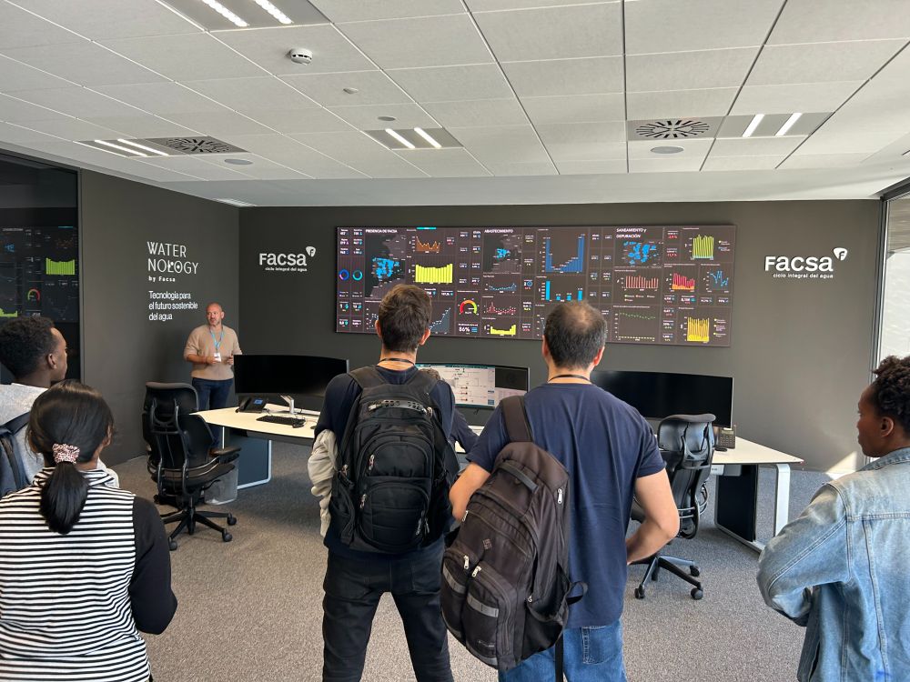
Once again we took the masters students to visit the enterprise GIS at FACSA, a large water company. The company went from a couple of GIS experts printing maps to 451 users (so far), many non-experts, thanks to webGIS apps. And loads of integration with other technical and business systems.


October 28, 2025 at 5:48 PM
Once again we took the masters students to visit the enterprise GIS at FACSA, a large water company. The company went from a couple of GIS experts printing maps to 451 users (so far), many non-experts, thanks to webGIS apps. And loads of integration with other technical and business systems.

Happy to see hidinginplainssight.org — my WebGIS project with Brian Holmes — included in Anthropocene Campus Chicago at Watershed Art & Ecology.
Thanks to Carlina Rossée for spotting it — wish I could be there in person.
#Anthropocene #Kansas #WebGIS
Thanks to Carlina Rossée for spotting it — wish I could be there in person.
#Anthropocene #Kansas #WebGIS


October 23, 2025 at 8:37 AM
Happy to see hidinginplainssight.org — my WebGIS project with Brian Holmes — included in Anthropocene Campus Chicago at Watershed Art & Ecology.
Thanks to Carlina Rossée for spotting it — wish I could be there in person.
#Anthropocene #Kansas #WebGIS
Thanks to Carlina Rossée for spotting it — wish I could be there in person.
#Anthropocene #Kansas #WebGIS

#GEUS har sammen med #Energistyrelsen lavet den første landsdækkende kortlægning af havbunden i de danske farvande. Resultater er samlet i rapport og webGIS-portal, som giver overblik over vigtige geologiske forhold med betydning for, hvor havvindmøller kan placeres.
www.geus.dk/om-geus/nyhe...
www.geus.dk/om-geus/nyhe...

Første landsdækkende kortlægning af havbunden baner vej for havvindmøller
GEUS har sammen med Energistyrelsen gennemført den første landsdækkende kortlægning af havbunden i de danske farvande. Resultaterne er samlet i en rapport og en webGIS-portal, som giver et samlet over...
www.geus.dk
October 2, 2025 at 11:33 AM
#GEUS har sammen med #Energistyrelsen lavet den første landsdækkende kortlægning af havbunden i de danske farvande. Resultater er samlet i rapport og webGIS-portal, som giver overblik over vigtige geologiske forhold med betydning for, hvor havvindmøller kan placeres.
www.geus.dk/om-geus/nyhe...
www.geus.dk/om-geus/nyhe...

Breakfast hosted by @geospatialwomen.bsky.social
🎤 Feye Andal!
@openstreetmap.bsky.social -Philippines
est. YouthMappers chapter
fmr Region Ambassador
WebGIS, UP Resilience Inst-NOAH Cntr & #GIS consult, @adb.org
Geospatial World's 50 Rising Stars
Spnsr = Digital Earth Pacific Community-SPC
🎤 Feye Andal!
@openstreetmap.bsky.social -Philippines
est. YouthMappers chapter
fmr Region Ambassador
WebGIS, UP Resilience Inst-NOAH Cntr & #GIS consult, @adb.org
Geospatial World's 50 Rising Stars
Spnsr = Digital Earth Pacific Community-SPC

September 30, 2025 at 6:22 AM
Breakfast hosted by @geospatialwomen.bsky.social
🎤 Feye Andal!
@openstreetmap.bsky.social -Philippines
est. YouthMappers chapter
fmr Region Ambassador
WebGIS, UP Resilience Inst-NOAH Cntr & #GIS consult, @adb.org
Geospatial World's 50 Rising Stars
Spnsr = Digital Earth Pacific Community-SPC
🎤 Feye Andal!
@openstreetmap.bsky.social -Philippines
est. YouthMappers chapter
fmr Region Ambassador
WebGIS, UP Resilience Inst-NOAH Cntr & #GIS consult, @adb.org
Geospatial World's 50 Rising Stars
Spnsr = Digital Earth Pacific Community-SPC
Get started with distributed #collaboration in #ArcGIS: New video series tinyurl.com/mws5drxu
#data #sharing #DataMgmt #GIS #esri #GIO #WebGIS #GISchat #geospatial #ArcGISAdmin #ArcGISOnline #ArcGISEnterprise #geosky
#data #sharing #DataMgmt #GIS #esri #GIO #WebGIS #GISchat #geospatial #ArcGISAdmin #ArcGISOnline #ArcGISEnterprise #geosky

September 22, 2025 at 1:11 PM
Get started with distributed #collaboration in #ArcGIS: New video series tinyurl.com/mws5drxu
#data #sharing #DataMgmt #GIS #esri #GIO #WebGIS #GISchat #geospatial #ArcGISAdmin #ArcGISOnline #ArcGISEnterprise #geosky
#data #sharing #DataMgmt #GIS #esri #GIO #WebGIS #GISchat #geospatial #ArcGISAdmin #ArcGISOnline #ArcGISEnterprise #geosky

Wie langsam kann eine Webseite laden in 2025?
Ein gutes Beispiel:
geo.stadt-muenster.de/webgis/muens...
Ein gutes Beispiel:
geo.stadt-muenster.de/webgis/muens...
Geodaten Stadt Münster
geo.stadt-muenster.de
September 21, 2025 at 7:50 AM
Wie langsam kann eine Webseite laden in 2025?
Ein gutes Beispiel:
geo.stadt-muenster.de/webgis/muens...
Ein gutes Beispiel:
geo.stadt-muenster.de/webgis/muens...

後輩が育たず、WebGIS用のデータ加工はできても、WebGISをカスタマイズするJavascriptコードを直したり新たに書き起こせるだけのスキルを持つ人が育ってない。
そのために、できる人に大きく負担がのしかかっている状況を背景に、顧客要望を叶える提案をせず、保守的にコード修正量を抑える後ろ向きな提案しかできていない。
そのために、できる人に大きく負担がのしかかっている状況を背景に、顧客要望を叶える提案をせず、保守的にコード修正量を抑える後ろ向きな提案しかできていない。
September 17, 2025 at 2:21 AM
後輩が育たず、WebGIS用のデータ加工はできても、WebGISをカスタマイズするJavascriptコードを直したり新たに書き起こせるだけのスキルを持つ人が育ってない。
そのために、できる人に大きく負担がのしかかっている状況を背景に、顧客要望を叶える提案をせず、保守的にコード修正量を抑える後ろ向きな提案しかできていない。
そのために、できる人に大きく負担がのしかかっている状況を背景に、顧客要望を叶える提案をせず、保守的にコード修正量を抑える後ろ向きな提案しかできていない。

Scottish Geology Festival 1 September to 12 October 2025. Events: www.scottishgeologytrust.org/festival/ or DIY, see what is near you on GeoGuide geoguide.scottishgeologytrust.org

September 14, 2025 at 11:13 AM
Scottish Geology Festival 1 September to 12 October 2025. Events: www.scottishgeologytrust.org/festival/ or DIY, see what is near you on GeoGuide geoguide.scottishgeologytrust.org
Das ist übrigens überall so an den neuen Fahrradabstellbügeln.
Die Poller sind in Bodenplatte nur eingeschoben und können schnell umgeworfen werden.
Wo ist überall?
geo.stadt-muenster.de/webgis/radst...
Die Poller sind in Bodenplatte nur eingeschoben und können schnell umgeworfen werden.
Wo ist überall?
geo.stadt-muenster.de/webgis/radst...


September 14, 2025 at 7:59 AM
Das ist übrigens überall so an den neuen Fahrradabstellbügeln.
Die Poller sind in Bodenplatte nur eingeschoben und können schnell umgeworfen werden.
Wo ist überall?
geo.stadt-muenster.de/webgis/radst...
Die Poller sind in Bodenplatte nur eingeschoben und können schnell umgeworfen werden.
Wo ist überall?
geo.stadt-muenster.de/webgis/radst...

文化財総覧WebGIS:令和7年(2025年)8月6日からの大雨に関するデータを追加 - なぶんけんブログ
www.nabunken.go.jp/nabunkenblog...
www.nabunken.go.jp/nabunkenblog...
August 21, 2025 at 1:32 PM
文化財総覧WebGIS:令和7年(2025年)8月6日からの大雨に関するデータを追加 - なぶんけんブログ
www.nabunken.go.jp/nabunkenblog...
www.nabunken.go.jp/nabunkenblog...

将来の天気はどうなっちゃうのかきになった人むけ
https://adaptation-platform.nies.go.jp/webgis/index.html
https://adaptation-platform.nies.go.jp/webgis/index.html

気候変動の将来予測WebGIS | 適応事例・データ | 気候変動適応情報プラットフォーム(A-PLAT)
「気候変動適応情報プラットフォーム(A-PLAT)」は、気候変動による悪影響をできるだけ抑制・回避し、また正の影響を活用した社会構築を目指す施策を進めるために参考となる情報を、分かりやすく発信するための情報基盤です。
adaptation-platform.nies.go.jp
August 5, 2025 at 9:23 AM
将来の天気はどうなっちゃうのかきになった人むけ
https://adaptation-platform.nies.go.jp/webgis/index.html
https://adaptation-platform.nies.go.jp/webgis/index.html

Discover how Needham's new WebGIS application is revolutionizing access to local geographic information and making community engagement easier than ever!
Learn more here
#TownofNeedhamNorfolkCounty #MA #CitizenPortal #NeedhamWebGIS #GeographicAccess #CommunityEngagement #LocalResources
Learn more here
#TownofNeedhamNorfolkCounty #MA #CitizenPortal #NeedhamWebGIS #GeographicAccess #CommunityEngagement #LocalResources

Needham Town Launches User-Friendly WebGIS for Interactive Mapping and Property Search
Needham introduces WebGIS for enhanced mapping, property information, and user engagement.
citizenportal.ai
August 1, 2025 at 2:53 PM
Discover how Needham's new WebGIS application is revolutionizing access to local geographic information and making community engagement easier than ever!
Learn more here
#TownofNeedhamNorfolkCounty #MA #CitizenPortal #NeedhamWebGIS #GeographicAccess #CommunityEngagement #LocalResources
Learn more here
#TownofNeedhamNorfolkCounty #MA #CitizenPortal #NeedhamWebGIS #GeographicAccess #CommunityEngagement #LocalResources
A comprehensive guide to migrating #ArcGIS content tinyurl.com/b9t5kf72
#data #DataMgmt #ArcGISAdmin #GIO #GIS #esri #WebGIS #ArcGISOnline #ArcGISEnterprise #GISchat #geospatial #geosky
#data #DataMgmt #ArcGISAdmin #GIO #GIS #esri #WebGIS #ArcGISOnline #ArcGISEnterprise #GISchat #geospatial #geosky

July 31, 2025 at 1:19 PM
A comprehensive guide to migrating #ArcGIS content tinyurl.com/b9t5kf72
#data #DataMgmt #ArcGISAdmin #GIO #GIS #esri #WebGIS #ArcGISOnline #ArcGISEnterprise #GISchat #geospatial #geosky
#data #DataMgmt #ArcGISAdmin #GIO #GIS #esri #WebGIS #ArcGISOnline #ArcGISEnterprise #GISchat #geospatial #geosky

📢 Esri is #hiring a Raster Product Engineer II - WebGIS!
💰 $76K - $128K
📍 Redlands, CA
🔗 http://jbs.ink/ZBYqie08d57H
#remotejob #remotework #wfh
💰 $76K - $128K
📍 Redlands, CA
🔗 http://jbs.ink/ZBYqie08d57H
#remotejob #remotework #wfh

July 21, 2025 at 2:12 AM
📢 Esri is #hiring a Raster Product Engineer II - WebGIS!
💰 $76K - $128K
📍 Redlands, CA
🔗 http://jbs.ink/ZBYqie08d57H
#remotejob #remotework #wfh
💰 $76K - $128K
📍 Redlands, CA
🔗 http://jbs.ink/ZBYqie08d57H
#remotejob #remotework #wfh
📢 Esri is #hiring a Raster Product Engineer II - WebGIS!
💰 $76K - $128K
📍 Redlands, CA
🔗 http://jbs.ink/ZBYqie08d57H
#remotejob #remotework #wfh
💰 $76K - $128K
📍 Redlands, CA
🔗 http://jbs.ink/ZBYqie08d57H
#remotejob #remotework #wfh
July 21, 2025 at 2:06 AM
📢 Esri is #hiring a Raster Product Engineer II - WebGIS!
💰 $76K - $128K
📍 Redlands, CA
🔗 http://jbs.ink/ZBYqie08d57H
#remotejob #remotework #wfh
💰 $76K - $128K
📍 Redlands, CA
🔗 http://jbs.ink/ZBYqie08d57H
#remotejob #remotework #wfh

Magenta Telekom sucht eine:n GIS-Mitarbeiter:in (w/m/d) für die WebGIS Applikation. Dienstort: Wien | ab sofort | Vollzeit | unbefristet.
Weitere Infos zum Job finden Sie unter:
jobberie.eu/job/gis-mita...
Weitere Infos zum Job finden Sie unter:
jobberie.eu/job/gis-mita...

GIS-Mitarbeiter:in (w/m/d) | JOBBERIE
Magenta Telekom sucht eine:n GIS-Mitarbeiter:in (w/m/d) für die WebGIS Applikation. Dienstort: Wien | ab sofort | Vollzeit | unbefristet
jobberie.eu
July 11, 2025 at 6:02 AM
Magenta Telekom sucht eine:n GIS-Mitarbeiter:in (w/m/d) für die WebGIS Applikation. Dienstort: Wien | ab sofort | Vollzeit | unbefristet.
Weitere Infos zum Job finden Sie unter:
jobberie.eu/job/gis-mita...
Weitere Infos zum Job finden Sie unter:
jobberie.eu/job/gis-mita...
Introducing the #ArcGIS Arcade assistant (beta) in #ArcGISOnline tinyurl.com/yc65ada5
#AI #dataviz #mapping #maps #GIS #esri #WebGIS #GISchat #geospatial #TheScienceOfWhere #geosky
#AI #dataviz #mapping #maps #GIS #esri #WebGIS #GISchat #geospatial #TheScienceOfWhere #geosky

July 4, 2025 at 2:07 PM
Introducing the #ArcGIS Arcade assistant (beta) in #ArcGISOnline tinyurl.com/yc65ada5
#AI #dataviz #mapping #maps #GIS #esri #WebGIS #GISchat #geospatial #TheScienceOfWhere #geosky
#AI #dataviz #mapping #maps #GIS #esri #WebGIS #GISchat #geospatial #TheScienceOfWhere #geosky

ジオグラフ www.geograph.teikokushoin.co.jp
「当サイトは、地方自治体の都市計画の現場などで活用されているWebGIS「都市構造可視化計画」を基として、着想されました。「都市構造可視化計画」の3次元グラフは、「色」と「高さ」の表現を駆使することで、二つの要素が相互作用しているエリアを強調表現することができます。これを基に、学校向けのユーザーインターフェイスへの改良や、高校地理教育向けのデータの掲載を図ったのが、当サイトです。」
「当サイトは、地方自治体の都市計画の現場などで活用されているWebGIS「都市構造可視化計画」を基として、着想されました。「都市構造可視化計画」の3次元グラフは、「色」と「高さ」の表現を駆使することで、二つの要素が相互作用しているエリアを強調表現することができます。これを基に、学校向けのユーザーインターフェイスへの改良や、高校地理教育向けのデータの掲載を図ったのが、当サイトです。」
June 29, 2025 at 9:41 AM
ジオグラフ www.geograph.teikokushoin.co.jp
「当サイトは、地方自治体の都市計画の現場などで活用されているWebGIS「都市構造可視化計画」を基として、着想されました。「都市構造可視化計画」の3次元グラフは、「色」と「高さ」の表現を駆使することで、二つの要素が相互作用しているエリアを強調表現することができます。これを基に、学校向けのユーザーインターフェイスへの改良や、高校地理教育向けのデータの掲載を図ったのが、当サイトです。」
「当サイトは、地方自治体の都市計画の現場などで活用されているWebGIS「都市構造可視化計画」を基として、着想されました。「都市構造可視化計画」の3次元グラフは、「色」と「高さ」の表現を駆使することで、二つの要素が相互作用しているエリアを強調表現することができます。これを基に、学校向けのユーザーインターフェイスへの改良や、高校地理教育向けのデータの掲載を図ったのが、当サイトです。」

управління кормами включає SSFM-DSS для оптимізації вирощування Lespedeza cuneata в Алабамі, Джорджії та Південній Кароліні.
#Lespedeza #GIS #WebGIS
#Lespedeza #GIS #WebGIS
Управління кормами для малих фермерів
управління кормами включає SSFM-DSS для оптимізації вирощування Lespedeza cuneata в Алабамі, Джорджії та Південній Кароліні.
agriradar.news
June 27, 2025 at 5:03 AM
управління кормами включає SSFM-DSS для оптимізації вирощування Lespedeza cuneata в Алабамі, Джорджії та Південній Кароліні.
#Lespedeza #GIS #WebGIS
#Lespedeza #GIS #WebGIS