


ecodiv
@ecodiv.bsky.social
Lecturer and researcher with a passion for biodiversity, ecology, and spatial data analysis. Committed to open science and open-source solutions, especially in the geospatial realm.
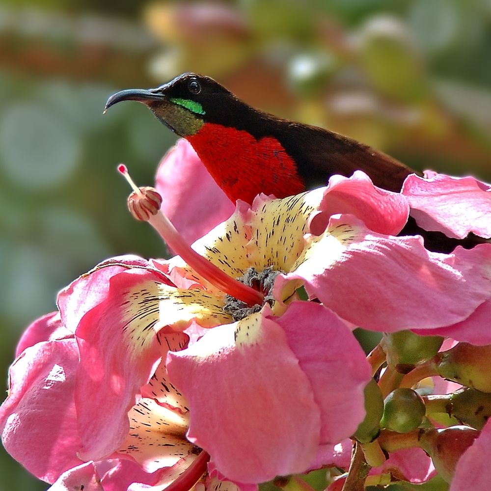
Cool! For those curious about the map, see vegetationmap4africa.org
September 5, 2025 at 5:48 PM
Cool! For those curious about the map, see vegetationmap4africa.org
A close-up of a dragonfly (Common Darter) perched on a broken bamboo stick, with its wings and body against a blurred, colorful background of red, green, and blue hues. Captured using a Fuji XT20 and Fujinon XF 100-400mm lens and processed using one of the best RAW editors, #Darktable .

August 28, 2025 at 7:13 PM
A close-up of a dragonfly (Common Darter) perched on a broken bamboo stick, with its wings and body against a blurred, colorful background of red, green, and blue hues. Captured using a Fuji XT20 and Fujinon XF 100-400mm lens and processed using one of the best RAW editors, #Darktable .
A white crab spider (Misumena vatia) with red markings is camouflaged on a vibrant pink flower, near its bright yellow center, against a soft green background. Taken with #FujiXT20 + #FUJINON XF 100-400mm with NISI close-up lens. Edited in #darktable #FOSS

July 28, 2025 at 6:34 PM
A white crab spider (Misumena vatia) with red markings is camouflaged on a vibrant pink flower, near its bright yellow center, against a soft green background. Taken with #FujiXT20 + #FUJINON XF 100-400mm with NISI close-up lens. Edited in #darktable #FOSS
A female european stonechat (Saxicola rubicola) calling out to her partners. #fujifilm #darktable #Photography #naturephotography

June 16, 2025 at 1:37 PM
A female european stonechat (Saxicola rubicola) calling out to her partners. #fujifilm #darktable #Photography #naturephotography
The western rock nuthatch (Sitta neumayer) has built its nest on a wall of the Roman Agora in Delphi, perfectly visible to the passing crowds of tourists just a few meters away. It didn’t seem to mind the attention. #darktable #fujifilm #foss

May 4, 2025 at 6:51 PM
The western rock nuthatch (Sitta neumayer) has built its nest on a wall of the Roman Agora in Delphi, perfectly visible to the passing crowds of tourists just a few meters away. It didn’t seem to mind the attention. #darktable #fujifilm #foss
I just stumbled across the site 'Interoperable Europe.' It seems worth looking into ( https://interoperable-europe.ec.europa.eu/ ). It is an initiative of the European Commission to stimulate public sector interoperability.
There isn't much (yet) on Geo-spatial tools, but at least #grassgis is
There isn't much (yet) on Geo-spatial tools, but at least #grassgis is

Interoperable Europe Portal
The Interoperable Europe Portal is the European Union’s platform for promoting and supporting interoperability, collaboration, and knowledge sharing across public administrations, businesses, and citizens. It acts as a one-stop shop for discovering, sharing, and reusing IT solutions and good practices.
interoperable-europe.ec.europa.eu
April 4, 2025 at 9:45 AM
I just stumbled across the site 'Interoperable Europe.' It seems worth looking into ( https://interoperable-europe.ec.europa.eu/ ). It is an initiative of the European Commission to stimulate public sector interoperability.
There isn't much (yet) on Geo-spatial tools, but at least #grassgis is
There isn't much (yet) on Geo-spatial tools, but at least #grassgis is
Always on the hunt for the ideal note-taking app. 🧠 I tried #Logseq , and while I loved the logbook, I prefer to organize my notes in a tree-like hierarchy. It helps me to keep an overview.
I therefore switched to TriliumNext ( https://github.com/triliumnext ). The option to place notes as
I therefore switched to TriliumNext ( https://github.com/triliumnext ). The option to place notes as

March 29, 2025 at 9:14 PM
Always on the hunt for the ideal note-taking app. 🧠 I tried #Logseq , and while I loved the logbook, I prefer to organize my notes in a tree-like hierarchy. It helps me to keep an overview.
I therefore switched to TriliumNext ( https://github.com/triliumnext ). The option to place notes as
I therefore switched to TriliumNext ( https://github.com/triliumnext ). The option to place notes as
I have been playing with the QGIS model designer a bit more. This time, to create a model that I can use to quickly compare how two raster layers by plotting their values in a scatter plot. https://ecodiv.earth/post/raster_scatterplot/ . #QGIS #FOSS #osgeo #datavisualization

March 22, 2025 at 3:26 PM
I have been playing with the QGIS model designer a bit more. This time, to create a model that I can use to quickly compare how two raster layers by plotting their values in a scatter plot. https://ecodiv.earth/post/raster_scatterplot/ . #QGIS #FOSS #osgeo #datavisualization
I am in the process of moving my shared pictures from one of the big tech platforms to my own hosted #piwigo instance. Together with #Digikam , which I use to manage my photos, it works like a charm 😃. FOSS rocks! #foss #darktable #photography https://piwigo.org/

March 16, 2025 at 4:52 PM
I am in the process of moving my shared pictures from one of the big tech platforms to my own hosted #piwigo instance. Together with #Digikam , which I use to manage my photos, it works like a charm 😃. FOSS rocks! #foss #darktable #photography https://piwigo.org/
Playing with the #NiSi 77mm close up lens on my #fujifilmXT30II. The picture isn't very sharp, those were tiny droplets, but I still like the overall result. #fujifilm #darktable #foss

March 8, 2025 at 10:16 AM
Playing with the #NiSi 77mm close up lens on my #fujifilmXT30II. The picture isn't very sharp, those were tiny droplets, but I still like the overall result. #fujifilm #darktable #foss
Ever needed to reuse the same raster extent & resolution across multiple QGIS tasks? My latest blog post shows how the Raster Layer Properties function can automatically grab all those details from a reference layer. A good way to make your workflows more consistent and error-proof.

March 6, 2025 at 9:47 AM
Ever needed to reuse the same raster extent & resolution across multiple QGIS tasks? My latest blog post shows how the Raster Layer Properties function can automatically grab all those details from a reference layer. A good way to make your workflows more consistent and error-proof.
We just wrapped up the first 2.5 years of the Save The Tiger project: https://savethetiger.nl/research/what-we-did-so-far/
Next week, a new group of #HASgreenacademy students heads to Nepal for #fieldwork in the beautiful Chitwan and Bardia NP's. Wish I could join them #savethetiger #Nepal
Next week, a new group of #HASgreenacademy students heads to Nepal for #fieldwork in the beautiful Chitwan and Bardia NP's. Wish I could join them #savethetiger #Nepal

February 16, 2025 at 3:45 PM
We just wrapped up the first 2.5 years of the Save The Tiger project: https://savethetiger.nl/research/what-we-did-so-far/
Next week, a new group of #HASgreenacademy students heads to Nepal for #fieldwork in the beautiful Chitwan and Bardia NP's. Wish I could join them #savethetiger #Nepal
Next week, a new group of #HASgreenacademy students heads to Nepal for #fieldwork in the beautiful Chitwan and Bardia NP's. Wish I could join them #savethetiger #Nepal
Explore species distribution modeling with Maxent in GRASS GIS? Check out my new post about the new addons and tutorial!
Read more: ecodiv.earth/post/sdm_usi...
#OpenSource #grassgis #GeoSpatial #osgeo #biogeography #ecology #modeling
Read more: ecodiv.earth/post/sdm_usi...
#OpenSource #grassgis #GeoSpatial #osgeo #biogeography #ecology #modeling

February 16, 2025 at 10:46 AM
Explore species distribution modeling with Maxent in GRASS GIS? Check out my new post about the new addons and tutorial!
Read more: ecodiv.earth/post/sdm_usi...
#OpenSource #grassgis #GeoSpatial #osgeo #biogeography #ecology #modeling
Read more: ecodiv.earth/post/sdm_usi...
#OpenSource #grassgis #GeoSpatial #osgeo #biogeography #ecology #modeling