


Conor Graham
@geoconor.bsky.social
Geography Jedi, GIS, Survey, Geomatics and Mapping. Geographer, MTBr and Moto rider. CO2BN 331ppm 🌍🛰️🌋🚴🏻♀️ Centre for GIS & Geomatics #QUB #Belfast #BikeisBest #drones4good #badcartographer maps@ https://geo-graphica.com/
Pinned
Conor Graham
@geoconor.bsky.social
· Jul 2
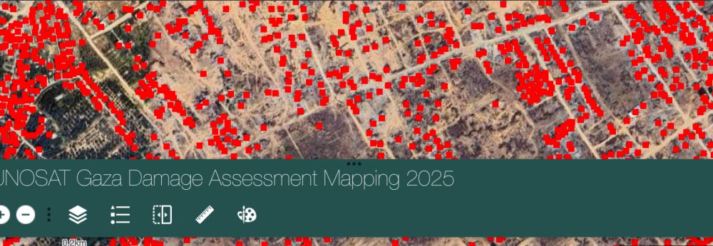
According to satellite imagery analysis of the Gaza Strip, UNOSAT has identified 70,436 destroyed structures. As of 02/25 it estimates 70% of all structures in Gaza have been destroyed or damaged.
You can view the data on this map.
go.qub.ac.uk/gazamapper
You can view the data on this map.
go.qub.ac.uk/gazamapper
If you get the chance check out @leoprints.bsky.social exhibition on the ground floor of the City Hospital. 40 year anniversary of the iconic 'Thunderbird Building'. Go for the prints, stay for the maps 😍


January 27, 2026 at 5:57 PM
If you get the chance check out @leoprints.bsky.social exhibition on the ground floor of the City Hospital. 40 year anniversary of the iconic 'Thunderbird Building'. Go for the prints, stay for the maps 😍
My Newry girlfriend 🦴

January 25, 2026 at 6:27 PM
My Newry girlfriend 🦴

Ah the 'wear yellow so I can see you' is the weapons grade level of victim blaming 🙄
“The notion that ever more garish clothing will compensate for distracted driving is a convenient fiction. No amount of fluorescent fabric can counteract the motorist scrolling on their phone or the driver travelling too fast.”
Sophie McDermott
#cycling #driving #danger #roadsafety
Sophie McDermott
#cycling #driving #danger #roadsafety

January 24, 2026 at 3:27 PM
Ah the 'wear yellow so I can see you' is the weapons grade level of victim blaming 🙄
Reposted by Conor Graham
Belfast city Hospital Tower block is celebrating 40 years of being a weird brutalist erratic on the Belfast skyline and I was commissioned to make some art for the exhibition in the hospital.
The exhibition is called 40 never looked so good and runs until April.
@belfasttrust.bsky.social
The exhibition is called 40 never looked so good and runs until April.
@belfasttrust.bsky.social


January 22, 2026 at 9:16 AM
Belfast city Hospital Tower block is celebrating 40 years of being a weird brutalist erratic on the Belfast skyline and I was commissioned to make some art for the exhibition in the hospital.
The exhibition is called 40 never looked so good and runs until April.
@belfasttrust.bsky.social
The exhibition is called 40 never looked so good and runs until April.
@belfasttrust.bsky.social
Reposted by Conor Graham

Dr. Gladys West, the pioneering mathematician whose work laid the foundation for modern GPS technology, has died. She was 95.

Dr. Gladys West, Mathematician Whose Work Made GPS Possible, Dies at 95
ALEXANDRIA, VA — Dr. Gladys West, the pioneering mathematician whose work laid the foundation for modern GPS technology, has died. She passed away
thezebra.org
January 19, 2026 at 6:00 PM
Dr. Gladys West, the pioneering mathematician whose work laid the foundation for modern GPS technology, has died. She was 95.
Reposted by Conor Graham
In December, we ran a campaign to switch the Sentinel-2A satellite on at night over some specific areas.
The goal was to provide data to help me work out how useful night imaging capabilities would be for next gen Sentinel-2...and the results are wonderful!
Read more:
www.esa.int/Applications...
The goal was to provide data to help me work out how useful night imaging capabilities would be for next gen Sentinel-2...and the results are wonderful!
Read more:
www.esa.int/Applications...


January 19, 2026 at 11:17 AM
In December, we ran a campaign to switch the Sentinel-2A satellite on at night over some specific areas.
The goal was to provide data to help me work out how useful night imaging capabilities would be for next gen Sentinel-2...and the results are wonderful!
Read more:
www.esa.int/Applications...
The goal was to provide data to help me work out how useful night imaging capabilities would be for next gen Sentinel-2...and the results are wonderful!
Read more:
www.esa.int/Applications...
The Purple Pocket Rocket will live for ever 😎💜 www.forbes.com/sites/hughmc...

Prince’s Masterpiece Reaches A New Peak Decades After Its Release
Prince's Purple Rain soundtrack hits a new all-time high more than 40 years after its release thanks to the use of "Purple Rain" and "When Doves Cry" in Stranger Things.
www.forbes.com
January 18, 2026 at 5:15 PM
The Purple Pocket Rocket will live for ever 😎💜 www.forbes.com/sites/hughmc...
Reposted by Conor Graham

If you read one thing today, it should be this
Iran report says 16,500 dead in ‘genocide under digital darkness’
www.thetimes.com/article/01ba...
Iran report says 16,500 dead in ‘genocide under digital darkness’
www.thetimes.com/article/01ba...

Iran report says 16,500 dead in ‘genocide under digital darkness’
Witnesses tell of the brutality inflicted on those taking part in anti-regime protests
www.thetimes.com
January 18, 2026 at 10:04 AM
If you read one thing today, it should be this
Iran report says 16,500 dead in ‘genocide under digital darkness’
www.thetimes.com/article/01ba...
Iran report says 16,500 dead in ‘genocide under digital darkness’
www.thetimes.com/article/01ba...
If you are in the SU @qubelfastofficial.bsky.social call by the reception desk and ask Harshini to show you the 3d tactile map tile. The map is centered around the union building and main campus 😎. It will help all visitors get their bearings on first visits 🤓🗺️ #GIS #Mapping #Geography

January 15, 2026 at 8:31 PM
If you are in the SU @qubelfastofficial.bsky.social call by the reception desk and ask Harshini to show you the 3d tactile map tile. The map is centered around the union building and main campus 😎. It will help all visitors get their bearings on first visits 🤓🗺️ #GIS #Mapping #Geography
Tactile Mapping allows people with visual impairment to physically experience/access mapping & spatial data. Combining high contrast colour combinations, with the aid of 3d printing, improves the user experience and accessibility. This 25x25cm 1/2500 scale tile based on OpenStreetMap data. #GIS

January 11, 2026 at 8:04 PM
Tactile Mapping allows people with visual impairment to physically experience/access mapping & spatial data. Combining high contrast colour combinations, with the aid of 3d printing, improves the user experience and accessibility. This 25x25cm 1/2500 scale tile based on OpenStreetMap data. #GIS
Sadly @qubelfastofficial.bsky.social are still active across multiple accounts 😞

58% of UK Universities still actively posting on X - even being the majority is not a good look.
It’ll look even worse when another dozen or so from the 141 finally cease using that horrendous platform.
It’ll look even worse when another dozen or so from the 141 finally cease using that horrendous platform.
January 10, 2026 at 11:29 AM
Sadly @qubelfastofficial.bsky.social are still active across multiple accounts 😞
Local news news here covering the work of Renee Good here in NI on Christian Youth Missions. BBC News - 'A beautiful spirit' - the Christian work of woman shot dead by ICE
www.bbc.co.uk/news/article...
www.bbc.co.uk/news/article...

Renee Nicole Good: Christian work of woman shot dead by ICE agent
Becca Hainsworth shared a room with Good during one of her stays in Northern Ireland and said her soul is crushed at the loss of her friend.
www.bbc.co.uk
January 9, 2026 at 5:18 PM
Local news news here covering the work of Renee Good here in NI on Christian Youth Missions. BBC News - 'A beautiful spirit' - the Christian work of woman shot dead by ICE
www.bbc.co.uk/news/article...
www.bbc.co.uk/news/article...
Reposted by Conor Graham

I'm cranking the heat AND the fun up this Saturday afternoon at 3pm with a hot bunch of Erotic Monster tunes. I think we could all do with some warm giggles, kitchen dancing and utter filth. I'd love you to join me 🪩 🔥
www.lovewillsavetheday.fm
www.lovewillsavetheday.fm

January 8, 2026 at 4:33 PM
I'm cranking the heat AND the fun up this Saturday afternoon at 3pm with a hot bunch of Erotic Monster tunes. I think we could all do with some warm giggles, kitchen dancing and utter filth. I'd love you to join me 🪩 🔥
www.lovewillsavetheday.fm
www.lovewillsavetheday.fm
Stranger Things has me listening to Purple Rain. Prince and this album was basically our sex ed growing up in 80's catholic boys school Newry 😂 💜 #Nicky

January 8, 2026 at 7:26 PM
Stranger Things has me listening to Purple Rain. Prince and this album was basically our sex ed growing up in 80's catholic boys school Newry 😂 💜 #Nicky
Local trail fun in the cold 🚵🏼❄️❤️ #RostrevorMTB


January 3, 2026 at 10:25 PM
Local trail fun in the cold 🚵🏼❄️❤️ #RostrevorMTB
Having been disappointed that LEGO didn't think to add Tom Crean to the recent 'Shackleton's Lifeboat' set I put him together myself 😃 #polar #explorers


December 19, 2025 at 1:00 AM
Having been disappointed that LEGO didn't think to add Tom Crean to the recent 'Shackleton's Lifeboat' set I put him together myself 😃 #polar #explorers
Reposted by Conor Graham

Reposted by Conor Graham

🛰️ “Curiosity, mentorship, and representation helped me build a career in photogrammetry and geospatial mapping.”
Check out Sandra's story on the Society of Women Engineers blog: 5 Lessons I Learned While Becoming a Photogrammetric Technician.
Check out Sandra's story on the Society of Women Engineers blog: 5 Lessons I Learned While Becoming a Photogrammetric Technician.

5 Lessons I Learned While Becoming a Photogrammetric Technician – All Together
Sandra Flores-Castillo shares how curiosity, mentorship, and representation shaped her journey to becoming a photogrammetric technician.
alltogether.swe.org
November 10, 2025 at 2:28 PM
🛰️ “Curiosity, mentorship, and representation helped me build a career in photogrammetry and geospatial mapping.”
Check out Sandra's story on the Society of Women Engineers blog: 5 Lessons I Learned While Becoming a Photogrammetric Technician.
Check out Sandra's story on the Society of Women Engineers blog: 5 Lessons I Learned While Becoming a Photogrammetric Technician.
Reposted by Conor Graham

A request for weather interested volunteers!
Met Eireann would like to rescue millions of weather observations taken in Ireland over many decades that are still stuck on paper. #WeatherRescue
Anyone can help: www.zooniverse.org/projects/met...
Met Eireann would like to rescue millions of weather observations taken in Ireland over many decades that are still stuck on paper. #WeatherRescue
Anyone can help: www.zooniverse.org/projects/met...

October 16, 2025 at 7:25 AM
A request for weather interested volunteers!
Met Eireann would like to rescue millions of weather observations taken in Ireland over many decades that are still stuck on paper. #WeatherRescue
Anyone can help: www.zooniverse.org/projects/met...
Met Eireann would like to rescue millions of weather observations taken in Ireland over many decades that are still stuck on paper. #WeatherRescue
Anyone can help: www.zooniverse.org/projects/met...
Reposted by Conor Graham
Good digital data is now being published by ASRS that presents the scale of landscape change that occurred as a result of the Matai'an landslide hazard cascade. There is also interesting information about the root causes of the vulnerability of the town of Guangfu.
eos.org/thelandslide...
eos.org/thelandslide...

October 2, 2025 at 7:55 AM
Good digital data is now being published by ASRS that presents the scale of landscape change that occurred as a result of the Matai'an landslide hazard cascade. There is also interesting information about the root causes of the vulnerability of the town of Guangfu.
eos.org/thelandslide...
eos.org/thelandslide...
You can view live AQ data here: smartcitizen.me/kits/18213. #Belfast
July 11, 2025 at 11:56 PM
You can view live AQ data here: smartcitizen.me/kits/18213. #Belfast
Given the NIHSE has failed to give any advice on the effect of large fires on contaminated land, here is a UK Gov 2007 report on asbestos in fire plumes. Fibers present do not uplift large distances but may disperse locally. The wind tonight in Belfast will be from the south. tinyurl.com/3tx3wded
tinyurl.com
July 11, 2025 at 12:00 PM
Given the NIHSE has failed to give any advice on the effect of large fires on contaminated land, here is a UK Gov 2007 report on asbestos in fire plumes. Fibers present do not uplift large distances but may disperse locally. The wind tonight in Belfast will be from the south. tinyurl.com/3tx3wded