


Joackiie
@joackiie.bsky.social
Senior meteorologist (M. Sc.), retired 😊
Passionate about all weather and science. Hiking and skiing.
Passionate about all weather and science. Hiking and skiing.
Reposted by Joackiie
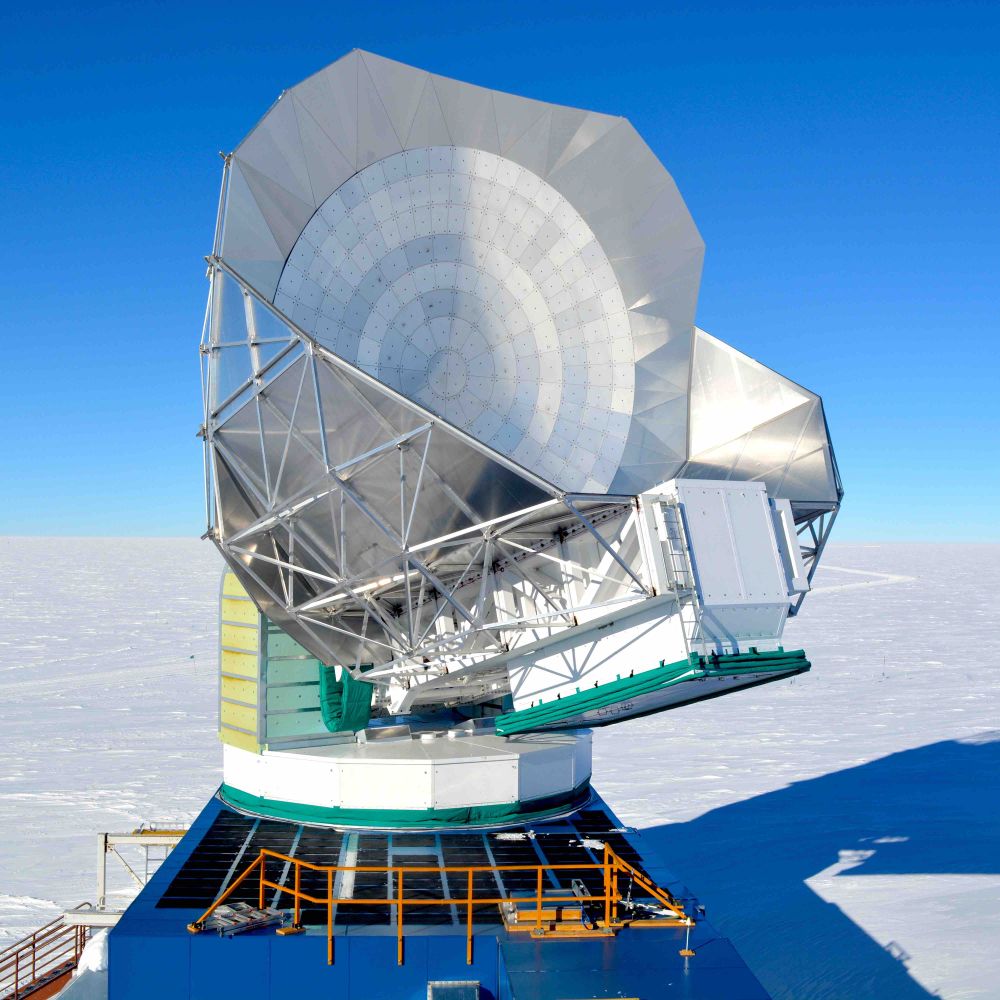
The first South Pole Overland Traverse (SPOT) of the season arrived at the #southpole this week! There are three traverses that travel between McMurdo and Pole each season, which bring about 75% of the fuel in each season. Pic by Michael Rayne. #Antartica @NSF

December 10, 2025 at 4:02 AM
The first South Pole Overland Traverse (SPOT) of the season arrived at the #southpole this week! There are three traverses that travel between McMurdo and Pole each season, which bring about 75% of the fuel in each season. Pic by Michael Rayne. #Antartica @NSF
Settled and exceptionally mild conditions across central Europe.
Meanwhile, a depression is developing over the eastern Atlantic, tracking across Ireland on Tuesday as low BRAM, with further intensification expected till midnight.
Expected maximum 24-hour wind gusts (km/h) for Tuesday from EURO1k.
Meanwhile, a depression is developing over the eastern Atlantic, tracking across Ireland on Tuesday as low BRAM, with further intensification expected till midnight.
Expected maximum 24-hour wind gusts (km/h) for Tuesday from EURO1k.


December 8, 2025 at 12:40 PM
Settled and exceptionally mild conditions across central Europe.
Meanwhile, a depression is developing over the eastern Atlantic, tracking across Ireland on Tuesday as low BRAM, with further intensification expected till midnight.
Expected maximum 24-hour wind gusts (km/h) for Tuesday from EURO1k.
Meanwhile, a depression is developing over the eastern Atlantic, tracking across Ireland on Tuesday as low BRAM, with further intensification expected till midnight.
Expected maximum 24-hour wind gusts (km/h) for Tuesday from EURO1k.
Reposted by Joackiie


Calender year 2025 so far: 2nd (globally) or 3rd (Europe) warmest since 1940 (ERA5)
Kudos to @climatologist49.bsky.social
Kudos to @climatologist49.bsky.social


December 6, 2025 at 1:39 PM
Calender year 2025 so far: 2nd (globally) or 3rd (Europe) warmest since 1940 (ERA5)
Kudos to @climatologist49.bsky.social
Kudos to @climatologist49.bsky.social
ERA5 temperature ranking for November and autumn 2025


December 5, 2025 at 9:27 AM
ERA5 temperature ranking for November and autumn 2025
Preliminary analyses of November 2025 using ERA5 data indicate that globally, it was the third-warmest November on record, while in Europe, it was the warmest since 1940.
Thx to @climatologist49.bsky.social
Thx to @climatologist49.bsky.social


December 5, 2025 at 7:59 AM
Preliminary analyses of November 2025 using ERA5 data indicate that globally, it was the third-warmest November on record, while in Europe, it was the warmest since 1940.
Thx to @climatologist49.bsky.social
Thx to @climatologist49.bsky.social
Today, the 1st of December, marks the commencement of the meteorological winter—a date designated just for climatological record-keeping purposes.
Snow cover today ↙️, as indicated by both model projections and select measurements, compared to the same date last year ↘️
Snow cover today ↙️, as indicated by both model projections and select measurements, compared to the same date last year ↘️


December 1, 2025 at 12:07 PM
Today, the 1st of December, marks the commencement of the meteorological winter—a date designated just for climatological record-keeping purposes.
Snow cover today ↙️, as indicated by both model projections and select measurements, compared to the same date last year ↘️
Snow cover today ↙️, as indicated by both model projections and select measurements, compared to the same date last year ↘️
Reposted by Joackiie

AIFS Ensemble plots are now available on PolarWx for a limited number of map projections: polarwx.com/models/?mode...


November 28, 2025 at 6:20 PM
AIFS Ensemble plots are now available on PolarWx for a limited number of map projections: polarwx.com/models/?mode...
Reposted by Joackiie

An interesting #spaceweather story developing. Airbus has made a statement saying that “Analysis of a recent event involving an A320 Family aircraft has revealed that intense solar radiation may corrupt data critical to the functioning of flight controls”
www.bbc.co.uk/news/article...
www.bbc.co.uk/news/article...

Flights disrupted as Airbus requests modifications to thousands of planes
About 6,000 plans are thought to be affected, about half the European aerospace giant's global fleet.
www.bbc.co.uk
November 28, 2025 at 8:12 PM
An interesting #spaceweather story developing. Airbus has made a statement saying that “Analysis of a recent event involving an A320 Family aircraft has revealed that intense solar radiation may corrupt data critical to the functioning of flight controls”
www.bbc.co.uk/news/article...
www.bbc.co.uk/news/article...
Once again sunny early-winter day in Switzerland, seen by Terra/Modis.
North of the Alps - above 600/700m amsl - now significant more snow than usual (source SLF).
Next week southern side of the Alps will finally also get the white stuff :-)
North of the Alps - above 600/700m amsl - now significant more snow than usual (source SLF).
Next week southern side of the Alps will finally also get the white stuff :-)


November 28, 2025 at 11:46 AM
Once again sunny early-winter day in Switzerland, seen by Terra/Modis.
North of the Alps - above 600/700m amsl - now significant more snow than usual (source SLF).
Next week southern side of the Alps will finally also get the white stuff :-)
North of the Alps - above 600/700m amsl - now significant more snow than usual (source SLF).
Next week southern side of the Alps will finally also get the white stuff :-)
Reposted by Joackiie

Updated animation of #CopernicusAtmosphere daily mean PM2.5 surface concentration forecasts showing development of Indo-Gangetic Plain #AirPollution between 1-27 November. More info/#OpenData access: ads.atmosphere.copernicus.eu/datasets/cam... #airquality @copernicusecmwf.bsky.social @ecmwf.int
November 27, 2025 at 7:53 PM
Updated animation of #CopernicusAtmosphere daily mean PM2.5 surface concentration forecasts showing development of Indo-Gangetic Plain #AirPollution between 1-27 November. More info/#OpenData access: ads.atmosphere.copernicus.eu/datasets/cam... #airquality @copernicusecmwf.bsky.social @ecmwf.int
November 2025 will end in Europe with temperatures again significantly above the 1981–2010 climatological reference period.
In the Alps, the marked anomalies of both very warm and very cold spells are expected to balance out, particularly when compared to the more recent 1991–2020 reference period
In the Alps, the marked anomalies of both very warm and very cold spells are expected to balance out, particularly when compared to the more recent 1991–2020 reference period

November 25, 2025 at 9:40 AM
November 2025 will end in Europe with temperatures again significantly above the 1981–2010 climatological reference period.
In the Alps, the marked anomalies of both very warm and very cold spells are expected to balance out, particularly when compared to the more recent 1991–2020 reference period
In the Alps, the marked anomalies of both very warm and very cold spells are expected to balance out, particularly when compared to the more recent 1991–2020 reference period
The recent onset of winter has resulted in above-average snowfall across Switzerland for late November; however, conditions are expected to change at the beginning of December.

November 24, 2025 at 2:28 PM
The recent onset of winter has resulted in above-average snowfall across Switzerland for late November; however, conditions are expected to change at the beginning of December.
Reposted by Joackiie

Derived Ash Height product from @eumetsat.int #meteosat10 suggested that parts of the volcanic ash cloud from the eruption of #HayliGubbi in Ethiopia may have reached heights in the 18-20 km range (black).
November 23, 2025 at 8:39 PM
Derived Ash Height product from @eumetsat.int #meteosat10 suggested that parts of the volcanic ash cloud from the eruption of #HayliGubbi in Ethiopia may have reached heights in the 18-20 km range (black).
Last night brought widespread frost, locally record lows, lower lows than last winter and alpine cold-air pools with –36.8°C surpassing temperatures in northern Norway!
Forecasts indicate a thaw on Monday, with milder conditions persisting until Christmas (Zurich ensemble) 😲
Forecasts indicate a thaw on Monday, with milder conditions persisting until Christmas (Zurich ensemble) 😲


November 23, 2025 at 7:40 AM
Last night brought widespread frost, locally record lows, lower lows than last winter and alpine cold-air pools with –36.8°C surpassing temperatures in northern Norway!
Forecasts indicate a thaw on Monday, with milder conditions persisting until Christmas (Zurich ensemble) 😲
Forecasts indicate a thaw on Monday, with milder conditions persisting until Christmas (Zurich ensemble) 😲
Following >50 cm of fresh snow locally over the past three days (@slfdavos.bsky.social), today in the Swiss Alps sunny weather with wintry snow cover (blue-tinted).
Low stratus over the lowlands, neatly streaked by northeasterly winds.
Low stratus over the lowlands, neatly streaked by northeasterly winds.


November 22, 2025 at 12:06 PM
Following >50 cm of fresh snow locally over the past three days (@slfdavos.bsky.social), today in the Swiss Alps sunny weather with wintry snow cover (blue-tinted).
Low stratus over the lowlands, neatly streaked by northeasterly winds.
Low stratus over the lowlands, neatly streaked by northeasterly winds.
Thick smog over India and Kashmir valley, fog/low stratus in the valleys of Nepal ... as seen by Terra/MODIS on Saturday noon.

November 22, 2025 at 11:26 AM
Thick smog over India and Kashmir valley, fog/low stratus in the valleys of Nepal ... as seen by Terra/MODIS on Saturday noon.
Arctic air from Greenland, fresh snow, and clear Saturday-night: perfect recipe for severe cold across Central Europe by Sunday morning.
Only southern Alpine lakes remained frost-free; some alpine valleys may reach –30°C!
A thaw is already expected next week...
Only southern Alpine lakes remained frost-free; some alpine valleys may reach –30°C!
A thaw is already expected next week...


November 21, 2025 at 8:43 AM
Arctic air from Greenland, fresh snow, and clear Saturday-night: perfect recipe for severe cold across Central Europe by Sunday morning.
Only southern Alpine lakes remained frost-free; some alpine valleys may reach –30°C!
A thaw is already expected next week...
Only southern Alpine lakes remained frost-free; some alpine valleys may reach –30°C!
A thaw is already expected next week...
Reposted by Joackiie
A polar vortex of confusion simonleewx.com/2025/11/20/a...

A polar vortex of confusion
Meteorologists have a historical penchant for giving names to atmospheric phenomena which, in today’s world, sound rather like phrases made up to fit a dramatic headline than real scientific …
simonleewx.com
November 20, 2025 at 11:52 AM
A polar vortex of confusion simonleewx.com/2025/11/20/a...
Reposted by Joackiie
1,019 glaciers have disappeared since 1973 in Switzerland! ✝️
1st nationwide assessment of vanished glaciers:
>40% of the glaciers inventoried in 1973
~13% (47±3 km²) of total glacier area loss! 🧊🔥
But, as it is based on the latest inventory (from 2016), the actual figures are far much higher! 📈 😰
1st nationwide assessment of vanished glaciers:
>40% of the glaciers inventoried in 1973
~13% (47±3 km²) of total glacier area loss! 🧊🔥
But, as it is based on the latest inventory (from 2016), the actual figures are far much higher! 📈 😰

November 19, 2025 at 12:05 PM
1,019 glaciers have disappeared since 1973 in Switzerland! ✝️
1st nationwide assessment of vanished glaciers:
>40% of the glaciers inventoried in 1973
~13% (47±3 km²) of total glacier area loss! 🧊🔥
But, as it is based on the latest inventory (from 2016), the actual figures are far much higher! 📈 😰
1st nationwide assessment of vanished glaciers:
>40% of the glaciers inventoried in 1973
~13% (47±3 km²) of total glacier area loss! 🧊🔥
But, as it is based on the latest inventory (from 2016), the actual figures are far much higher! 📈 😰
Recent SSTAs (sea surface temperature anomalies) clearly indicate La Niña in the tropical Pacific, expected to persist until the end of winter.
This has little direct impact on our winter weather; instead, the seas around Europe—currently much warmer than average—play a more significant role
This has little direct impact on our winter weather; instead, the seas around Europe—currently much warmer than average—play a more significant role

November 18, 2025 at 5:53 PM
Recent SSTAs (sea surface temperature anomalies) clearly indicate La Niña in the tropical Pacific, expected to persist until the end of winter.
This has little direct impact on our winter weather; instead, the seas around Europe—currently much warmer than average—play a more significant role
This has little direct impact on our winter weather; instead, the seas around Europe—currently much warmer than average—play a more significant role
Reposted by Joackiie

The global record 134 °F surface temp, measured in Death Valley in 1913, is "implausible" based on other records from that date, claims a paper in #BulletinAMS. The authors suggest the temperature was recorded at an improper location.
More on the blog: https://bit.ly/3LCKPgS
More on the blog: https://bit.ly/3LCKPgS

Global Record in Question: Could Death Valley lose its claim to “world’s hottest place”?
New analysis of the Death Valley record for hottest weather-related air-surface temperature recorded on Earth suggests the record is “implausible.”…
bit.ly
November 18, 2025 at 5:44 PM
The global record 134 °F surface temp, measured in Death Valley in 1913, is "implausible" based on other records from that date, claims a paper in #BulletinAMS. The authors suggest the temperature was recorded at an improper location.
More on the blog: https://bit.ly/3LCKPgS
More on the blog: https://bit.ly/3LCKPgS
Arctic air surging from Greenland brought last night the lowest temperatures in the High Alps since early March: Capanna Margherita near Monte Rosa recorded –21.9°C.
First fresh snow (coloured blue) down to ~700 m in eastern Switzerland and southern Germany.
First fresh snow (coloured blue) down to ~700 m in eastern Switzerland and southern Germany.


November 18, 2025 at 10:50 AM
Arctic air surging from Greenland brought last night the lowest temperatures in the High Alps since early March: Capanna Margherita near Monte Rosa recorded –21.9°C.
First fresh snow (coloured blue) down to ~700 m in eastern Switzerland and southern Germany.
First fresh snow (coloured blue) down to ~700 m in eastern Switzerland and southern Germany.
Record warmth still over southern Europe/northern Africa↙️ ... but in 150 hours with arctic air from Greenland follows record cold ↘️


November 16, 2025 at 10:27 AM
Record warmth still over southern Europe/northern Africa↙️ ... but in 150 hours with arctic air from Greenland follows record cold ↘️
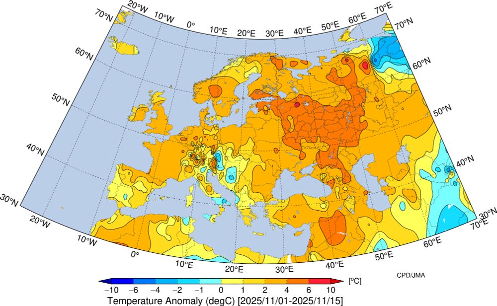
First half of November 2025 was in Europe mostly too warm.
In Switzerland about +1 (south) to +5 (mountains) degrees warmer than usual - now followed by a colder second half.
In Switzerland about +1 (south) to +5 (mountains) degrees warmer than usual - now followed by a colder second half.
November 16, 2025 at 8:32 AM
First half of November 2025 was in Europe mostly too warm.
In Switzerland about +1 (south) to +5 (mountains) degrees warmer than usual - now followed by a colder second half.
In Switzerland about +1 (south) to +5 (mountains) degrees warmer than usual - now followed by a colder second half.