


Mika Rantanen
@mikarantane.bsky.social
Researcher at the Finnish Meteorological Institute. Climate change, extreme weather and attribution of extreme events. PhD in meteorology from the University of Helsinki.
Pinned
Mika Rantanen
@mikarantane.bsky.social
· Apr 28
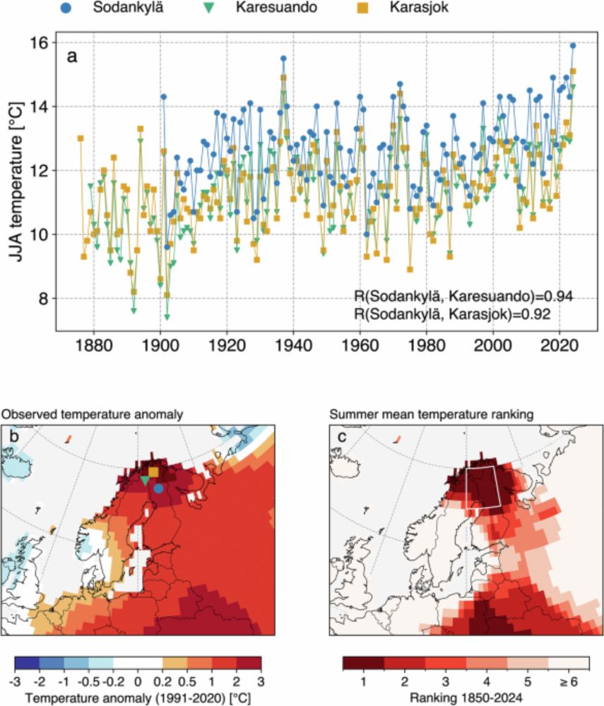
Summer 2024 in northern Fennoscandia was very likely the warmest in 2000 years - npj Climate and Atmospheric Science
npj Climate and Atmospheric Science - Summer 2024 in northern Fennoscandia was very likely the warmest in 2000 years
doi.org
Excited to share that our new paper
“Summer 2024 in northern Fennoscandia was very likely the warmest in 2000 years”
has been published in npj Climate and Atmospheric Science!
See the open-access paper from doi.org/10.1038/s416...
Short thread 👇
“Summer 2024 in northern Fennoscandia was very likely the warmest in 2000 years”
has been published in npj Climate and Atmospheric Science!
See the open-access paper from doi.org/10.1038/s416...
Short thread 👇
Alhainen vedenkorkeus ja jäätilanne muuttavat saariston lauttareittejä – osa ajetaan nyt ilmatyynyaluksilla
yle.fi/a/74-2020832...
yle.fi/a/74-2020832...

Alhainen vedenkorkeus ja jäätilanne muuttavat saariston lauttareittejä – osa ajetaan nyt ilmatyynyaluksilla
Lautta- ja yhteysalusliikennettä operoivan Finferries-yhtiön liikennepäällikkö ei muista yhtä pahaa tilannetta yli kaksikymmentävuotisen uransa ajalta.
yle.fi
February 4, 2026 at 5:04 PM
Alhainen vedenkorkeus ja jäätilanne muuttavat saariston lauttareittejä – osa ajetaan nyt ilmatyynyaluksilla
yle.fi/a/74-2020832...
yle.fi/a/74-2020832...
Tuosta keskusteltiin eilen @petraroiha.bsky.social kanssa. Vaatisi lännenpuoleisia myrskytuulia korkeapainejakson päätteeksi, mutta tällä hetkellä sellaisia ei ole näköpiirissä.
February 4, 2026 at 1:47 PM
Tuosta keskusteltiin eilen @petraroiha.bsky.social kanssa. Vaatisi lännenpuoleisia myrskytuulia korkeapainejakson päätteeksi, mutta tällä hetkellä sellaisia ei ole näköpiirissä.
Thus, it is possible that the total water volume in the entire Baltic Sea is currently one the lowest, if not the lowest on record.
This is due to the ongoing weather pattern (high pressure, northeasterly flow) that has pushed the water southwest, away from the Baltic Sea.
This is due to the ongoing weather pattern (high pressure, northeasterly flow) that has pushed the water southwest, away from the Baltic Sea.
February 4, 2026 at 10:12 AM
Thus, it is possible that the total water volume in the entire Baltic Sea is currently one the lowest, if not the lowest on record.
This is due to the ongoing weather pattern (high pressure, northeasterly flow) that has pushed the water southwest, away from the Baltic Sea.
This is due to the ongoing weather pattern (high pressure, northeasterly flow) that has pushed the water southwest, away from the Baltic Sea.
What makes this minimum record important is that the Föglö tide gauge is located at the northern edge of the main Baltic Sea basin.
Previous studies have shown that sea level variations at Föglö closely reflect changes in the total water volume of the Baltic Sea (e.g. doi.org/10.60910/28e...).
Previous studies have shown that sea level variations at Föglö closely reflect changes in the total water volume of the Baltic Sea (e.g. doi.org/10.60910/28e...).

February 4, 2026 at 10:12 AM
What makes this minimum record important is that the Föglö tide gauge is located at the northern edge of the main Baltic Sea basin.
Previous studies have shown that sea level variations at Föglö closely reflect changes in the total water volume of the Baltic Sea (e.g. doi.org/10.60910/28e...).
Previous studies have shown that sea level variations at Föglö closely reflect changes in the total water volume of the Baltic Sea (e.g. doi.org/10.60910/28e...).
New all-time minimum sea level in the Baltic Sea!
The Föglö tide gauge measured just -71.6 cm below the mean level which is the lowest value ever recorded there. Records have been kept over 100 years, since 1924 (!).
The sea level is still decreasing. (1/3)
The Föglö tide gauge measured just -71.6 cm below the mean level which is the lowest value ever recorded there. Records have been kept over 100 years, since 1924 (!).
The sea level is still decreasing. (1/3)

February 4, 2026 at 10:12 AM
New all-time minimum sea level in the Baltic Sea!
The Föglö tide gauge measured just -71.6 cm below the mean level which is the lowest value ever recorded there. Records have been kept over 100 years, since 1924 (!).
The sea level is still decreasing. (1/3)
The Föglö tide gauge measured just -71.6 cm below the mean level which is the lowest value ever recorded there. Records have been kept over 100 years, since 1924 (!).
The sea level is still decreasing. (1/3)
Yes, indeed. And correspondingly in a cooling planet, jet stream would become less wavy, leading to less cold air outbreaks.
It just sounds even more weird that rapid Arctic cooling would cause less cold extremes at mid-latitudes. But it should also work that way, right?
It just sounds even more weird that rapid Arctic cooling would cause less cold extremes at mid-latitudes. But it should also work that way, right?
February 3, 2026 at 7:40 PM
Yes, indeed. And correspondingly in a cooling planet, jet stream would become less wavy, leading to less cold air outbreaks.
It just sounds even more weird that rapid Arctic cooling would cause less cold extremes at mid-latitudes. But it should also work that way, right?
It just sounds even more weird that rapid Arctic cooling would cause less cold extremes at mid-latitudes. But it should also work that way, right?
In such an imaginary world, a cold air outbreak like the one we are experiencing now occurs.
Would we then argue that the *cooling Arctic* made this cold event less likely or less intense? I think it would sound strange.
Is this a meaningful comparison?
Would we then argue that the *cooling Arctic* made this cold event less likely or less intense? I think it would sound strange.
Is this a meaningful comparison?
February 3, 2026 at 7:10 PM
In such an imaginary world, a cold air outbreak like the one we are experiencing now occurs.
Would we then argue that the *cooling Arctic* made this cold event less likely or less intense? I think it would sound strange.
Is this a meaningful comparison?
Would we then argue that the *cooling Arctic* made this cold event less likely or less intense? I think it would sound strange.
Is this a meaningful comparison?
When I hear these cold extremes are associated to climate change, I often make a thought experiment in my head: imagine a counterfactual world in which climate change were causing global *cooling* rather than warming, and the Arctic would be cooling 4x faster than the global mean. 1/2

Is climate change responsible for increasingly frequent or severe cold events?
The evidence suggests it is not.
Instead, the impact of climate change is warmer winters and less severe cold events.
@hausfath.bsky.social has a great post on The Climate Brink talking about this.
The evidence suggests it is not.
Instead, the impact of climate change is warmer winters and less severe cold events.
@hausfath.bsky.social has a great post on The Climate Brink talking about this.

Fact check: Climate change is not making extreme cold more common
Sometimes it just gets cold
substack.com
February 3, 2026 at 7:10 PM
When I hear these cold extremes are associated to climate change, I often make a thought experiment in my head: imagine a counterfactual world in which climate change were causing global *cooling* rather than warming, and the Arctic would be cooling 4x faster than the global mean. 1/2
Reposted by Mika Rantanen

While there *is* evidence of both "wetter wets" & "drier dries" in warming climate, temperatures are going almost universally in one direction: Up. We're just not seeing "colder colds."
Some interesting potential Arctic-related caveats still remain TBD, but that doesn't change big picture.
Some interesting potential Arctic-related caveats still remain TBD, but that doesn't change big picture.
Is climate change responsible for increasingly frequent or severe cold events?
The evidence suggests it is not.
Instead, the impact of climate change is warmer winters and less severe cold events.
@hausfath.bsky.social has a great post on The Climate Brink talking about this.
The evidence suggests it is not.
Instead, the impact of climate change is warmer winters and less severe cold events.
@hausfath.bsky.social has a great post on The Climate Brink talking about this.
Fact check: Climate change is not making extreme cold more common
Sometimes it just gets cold
substack.com
February 3, 2026 at 1:57 AM
While there *is* evidence of both "wetter wets" & "drier dries" in warming climate, temperatures are going almost universally in one direction: Up. We're just not seeing "colder colds."
Some interesting potential Arctic-related caveats still remain TBD, but that doesn't change big picture.
Some interesting potential Arctic-related caveats still remain TBD, but that doesn't change big picture.
Reposted by Mika Rantanen
The weather regime that on average brings the coldest weather is warming the fastest in a large part of northern Europe. In contrast, the weather regime that typically brings the warmest weather has warmed the slowest.
doi.org/10.1002/asl.... @mikarantane.bsky.social
doi.org/10.1002/asl.... @mikarantane.bsky.social
Is climate change responsible for increasingly frequent or severe cold events?
The evidence suggests it is not.
Instead, the impact of climate change is warmer winters and less severe cold events.
@hausfath.bsky.social has a great post on The Climate Brink talking about this.
The evidence suggests it is not.
Instead, the impact of climate change is warmer winters and less severe cold events.
@hausfath.bsky.social has a great post on The Climate Brink talking about this.
Fact check: Climate change is not making extreme cold more common
Sometimes it just gets cold
substack.com
February 3, 2026 at 2:59 PM
The weather regime that on average brings the coldest weather is warming the fastest in a large part of northern Europe. In contrast, the weather regime that typically brings the warmest weather has warmed the slowest.
doi.org/10.1002/asl.... @mikarantane.bsky.social
doi.org/10.1002/asl.... @mikarantane.bsky.social
Helmikuun puoliväliin ehkä? Sen jälkeen ei ole takeita.
February 2, 2026 at 2:31 PM
Helmikuun puoliväliin ehkä? Sen jälkeen ei ole takeita.
Cold January! The wind rose from Helsinki Kaisaniemi shows that the most common wind direction so far this year has been from the northeast.
Wind has blown from that direction almost half (44%) of the time.
Wind has blown from that direction almost half (44%) of the time.

February 2, 2026 at 2:22 PM
Cold January! The wind rose from Helsinki Kaisaniemi shows that the most common wind direction so far this year has been from the northeast.
Wind has blown from that direction almost half (44%) of the time.
Wind has blown from that direction almost half (44%) of the time.
Juuri tippui alemmas, -63,7 cm, eli 2000-luvun alin lukema.
Kirjallisuuden mukaan Föglön havainnot vastaavat aika hyvin koko Itämeren vesimäärää, koska mareografi sijaitsee pääaltaan pohjoisreunalla.
Kirjallisuuden mukaan Föglön havainnot vastaavat aika hyvin koko Itämeren vesimäärää, koska mareografi sijaitsee pääaltaan pohjoisreunalla.
February 2, 2026 at 11:47 AM
Juuri tippui alemmas, -63,7 cm, eli 2000-luvun alin lukema.
Kirjallisuuden mukaan Föglön havainnot vastaavat aika hyvin koko Itämeren vesimäärää, koska mareografi sijaitsee pääaltaan pohjoisreunalla.
Kirjallisuuden mukaan Föglön havainnot vastaavat aika hyvin koko Itämeren vesimäärää, koska mareografi sijaitsee pääaltaan pohjoisreunalla.
January climate statistics are out. Remarkably in Lapland, January 2026 was the coldest month since January 1987!
www.ilmatieteenlaitos.fi/tiedote/1GU2...
www.ilmatieteenlaitos.fi/tiedote/1GU2...

February 2, 2026 at 9:21 AM
January climate statistics are out. Remarkably in Lapland, January 2026 was the coldest month since January 1987!
www.ilmatieteenlaitos.fi/tiedote/1GU2...
www.ilmatieteenlaitos.fi/tiedote/1GU2...
It's a result from the ongoing weather pattern. The high pressure and persistent northerly/northeasterly winds have pushed water away from the Baltic Sea.
February 2, 2026 at 7:42 AM
It's a result from the ongoing weather pattern. The high pressure and persistent northerly/northeasterly winds have pushed water away from the Baltic Sea.
The total water volume in the Baltic Sea continues to drop. The mean water level dropped to -62.0 cm at the Föglö tide gauge today morning.
This is now the 2nd lowest reading in the 21st century, surpassed only by the March 2013 cold wave (-63.4 cm).
en.ilmatieteenlaitos.fi/sea-level?se...
This is now the 2nd lowest reading in the 21st century, surpassed only by the March 2013 cold wave (-63.4 cm).
en.ilmatieteenlaitos.fi/sea-level?se...

February 2, 2026 at 7:20 AM
The total water volume in the Baltic Sea continues to drop. The mean water level dropped to -62.0 cm at the Föglö tide gauge today morning.
This is now the 2nd lowest reading in the 21st century, surpassed only by the March 2013 cold wave (-63.4 cm).
en.ilmatieteenlaitos.fi/sea-level?se...
This is now the 2nd lowest reading in the 21st century, surpassed only by the March 2013 cold wave (-63.4 cm).
en.ilmatieteenlaitos.fi/sea-level?se...
Reposted by Mika Rantanen
Helsinki saw its coldest January since 2016 with a mean temperature of -7.4°C.

February 1, 2026 at 1:20 PM
Helsinki saw its coldest January since 2016 with a mean temperature of -7.4°C.
The regions that have lost much ice show indeed the highest warning trend. In Finnish Lapland the trend is weaker.
In addition, the trend depends on the starting year of the trend. January has warmed too from the 1979.
Fig. from www.nature.com/articles/s43...
In addition, the trend depends on the starting year of the trend. January has warmed too from the 1979.
Fig. from www.nature.com/articles/s43...

February 1, 2026 at 6:58 AM
The regions that have lost much ice show indeed the highest warning trend. In Finnish Lapland the trend is weaker.
In addition, the trend depends on the starting year of the trend. January has warmed too from the 1979.
Fig. from www.nature.com/articles/s43...
In addition, the trend depends on the starting year of the trend. January has warmed too from the 1979.
Fig. from www.nature.com/articles/s43...
Interesting is also the seemingly lack of warming in January. The three warmest Januaries are 1925, 1934 and 2001.
Linear trend over 1901–2026 is -0.03°C/decade.
Centennial-scale lack of warming within the Arctic Circle must be rare? Could be a good topic for a small study.
Linear trend over 1901–2026 is -0.03°C/decade.
Centennial-scale lack of warming within the Arctic Circle must be rare? Could be a good topic for a small study.
January 31, 2026 at 11:35 AM
Interesting is also the seemingly lack of warming in January. The three warmest Januaries are 1925, 1934 and 2001.
Linear trend over 1901–2026 is -0.03°C/decade.
Centennial-scale lack of warming within the Arctic Circle must be rare? Could be a good topic for a small study.
Linear trend over 1901–2026 is -0.03°C/decade.
Centennial-scale lack of warming within the Arctic Circle must be rare? Could be a good topic for a small study.
January is soon in the books, and what an exceptionally cold month it has been in northern Fennoscandia!
The monthly mean temperature in Sodankylä Tähtelä will be -21.2 °C. This means coldest January since 1987 and 5th coldest overall.
The monthly mean temperature in Sodankylä Tähtelä will be -21.2 °C. This means coldest January since 1987 and 5th coldest overall.

January 31, 2026 at 11:35 AM
January is soon in the books, and what an exceptionally cold month it has been in northern Fennoscandia!
The monthly mean temperature in Sodankylä Tähtelä will be -21.2 °C. This means coldest January since 1987 and 5th coldest overall.
The monthly mean temperature in Sodankylä Tähtelä will be -21.2 °C. This means coldest January since 1987 and 5th coldest overall.
Reposted by Mika Rantanen

I've seen several Big Climate Accounts™ post about how the recent winter storm was made worse by climate change. It's a convenient narrative.
s
But what is "worse"? Colder temperatures? More snow? More freezing rain? Is there any primary literature supporting the idea of worse snowstorms?
1/
s
But what is "worse"? Colder temperatures? More snow? More freezing rain? Is there any primary literature supporting the idea of worse snowstorms?
1/
January 31, 2026 at 3:29 AM
I've seen several Big Climate Accounts™ post about how the recent winter storm was made worse by climate change. It's a convenient narrative.
s
But what is "worse"? Colder temperatures? More snow? More freezing rain? Is there any primary literature supporting the idea of worse snowstorms?
1/
s
But what is "worse"? Colder temperatures? More snow? More freezing rain? Is there any primary literature supporting the idea of worse snowstorms?
1/
Except not for cold extremes!
January 31, 2026 at 5:53 AM
Except not for cold extremes!
Kiitos! välillä mietin että lukeeko niitä kukaan.
Mutta joo, etelässä ei kyllä ollut kovin kylmää, ja muutenkin etelässä tuntuu kovimmat pakkaset vähentyneen selkeämmin kuin Lapissa.
Mutta joo, etelässä ei kyllä ollut kovin kylmää, ja muutenkin etelässä tuntuu kovimmat pakkaset vähentyneen selkeämmin kuin Lapissa.
January 30, 2026 at 1:52 PM
Kiitos! välillä mietin että lukeeko niitä kukaan.
Mutta joo, etelässä ei kyllä ollut kovin kylmää, ja muutenkin etelässä tuntuu kovimmat pakkaset vähentyneen selkeämmin kuin Lapissa.
Mutta joo, etelässä ei kyllä ollut kovin kylmää, ja muutenkin etelässä tuntuu kovimmat pakkaset vähentyneen selkeämmin kuin Lapissa.
Yritin etsiä jostain Laatokan jäätilannetta mutta en löytänyt! Meteorologit totesivat sisäisessä viestinnässä että "Laatokka on jo lähes kokonaan jäässä, samoin Perämerellä on laaja jääpeite."
January 30, 2026 at 10:21 AM
Yritin etsiä jostain Laatokan jäätilannetta mutta en löytänyt! Meteorologit totesivat sisäisessä viestinnässä että "Laatokka on jo lähes kokonaan jäässä, samoin Perämerellä on laaja jääpeite."
Extreme seasons recently in Finnish Lapland: both summer 2025 and winter 2026 featured the 3rd hottest and 3rd coldest two-week periods on record.
Data is based on FMI ClimGrid (available since 1961).
Data is based on FMI ClimGrid (available since 1961).


January 30, 2026 at 9:17 AM
Extreme seasons recently in Finnish Lapland: both summer 2025 and winter 2026 featured the 3rd hottest and 3rd coldest two-week periods on record.
Data is based on FMI ClimGrid (available since 1961).
Data is based on FMI ClimGrid (available since 1961).