Mika Rantanen
@mikarantane.bsky.social
6.7K followers 490 following 750 posts
Researcher in Weather and Climate Change Impact Research in Finnish Meteorological Institute. PhD in meteorology.
Posts Media Videos Starter Packs
Pinned
mikarantane.bsky.social
Excited to share that our new paper

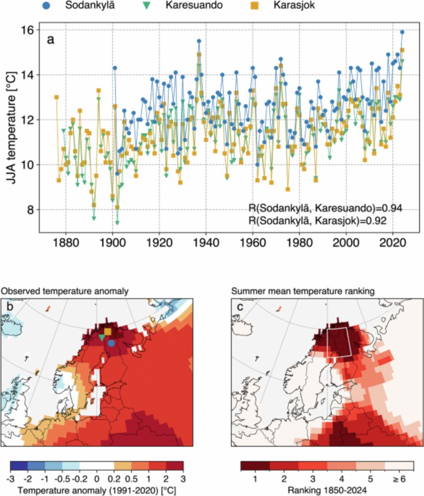
“Summer 2024 in northern Fennoscandia was very likely the warmest in 2000 years”

has been published in npj Climate and Atmospheric Science!

See the open-access paper from doi.org/10.1038/s416...

Short thread 👇
Summer 2024 in northern Fennoscandia was very likely the warmest in 2000 years - npj Climate and Atmospheric Science
npj Climate and Atmospheric Science - Summer 2024 in northern Fennoscandia was very likely the warmest in 2000 years
doi.org
Reposted by Mika Rantanen
oceanterra.org
The @copernicusecmwf.bsky.social climate monitoring application #Climate Pulse has been updated. Same climate monitoring data with new features and better layout. 🌏🌊⚒️🧪

User feedback always welcome so let us know what you would like to see updated in the next version:

pulse.climate.copernicus.eu
mikarantane.bsky.social
As far as I can tell, the "more frequent and intense" refers here to simulations without sea level rise. The simulations are run with constant CO₂ levels, so they do not take into account the warming climate. (as pointed out also by one reviewer)
bjerknes.uib.no
Rising sea levels are making extreme winter cold events MORE frequent and intense in East Asia. Yes, you read that right. New paper in Nature Communications reveals a fascinating connection. (1/4) 🧪🌊
Reposted by Mika Rantanen
ilmatieteenlaitos.fi
Ovatko sään ääri-ilmiöt haitanneet elämääsi? Vastaa kyselyyn!

Keräämme tietoa sään ääri-ilmiöiden koetuista haittavaikutuksista ja selvitämme, minkälaista tietoa tarvittaisiin niihin varautumiseksi.

Kyselyyn pääset tästä linkistä 🔽

link.webropolsurveys.com/Participatio...

📸 Jukka Salmi / Plugi.
Tulviva alikulku kesällä.
Reposted by Mika Rantanen
metoffice.gov.uk
Storm Amy has been record breaking ⚠️

An air pressure of 947.9 hPa was recorded at Baltasound, Shetland, provisionally setting a new UK lowest pressure record for October.

Northern Ireland provisionally recorded its strongest October wind gust on record, with a gust of 92 mph at Magilligan.
Reposted by Mika Rantanen
thissideofthearctic.org
Storm Amy is litterally giving Norway the finger, according to this weekend's forecast. 🌬️
mikarantane.bsky.social
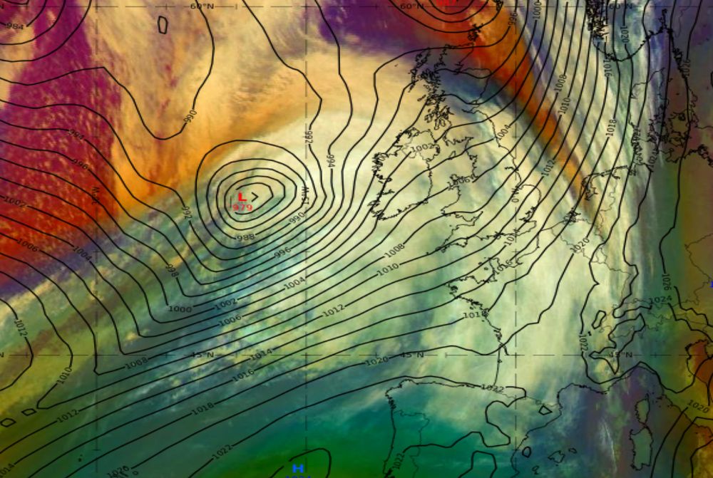
The rapid deepening of Storm Amy has begun.

Over the next hours, the storm will travel across the jet stream and move to the left exit region of the jet stream where the most explosive deepening will take place.
Satellite image of Storm Amy, overlaid with MSLP contours at 6 UTC. Screenshot from Eumetrain. MSLP and jet stream at 18 UTC in Europe. The figure is from https://www.atmos.albany.edu/student/abentley/realtime/standard.php?domain=europe&variable=mslp_jet.
mikarantane.bsky.social
Finland's regionally averaged temperature in September was the 3rd highest on record, but here you can see how Septembers 2023–2025 surpass all previous years since 1900.
A graph showing September mean temperature in Finland in 1900–2025
Reposted by Mika Rantanen
simonleewx.com
Per the Met Office forecast charts, the system deepens by 43 hPa between 00Z Friday and 00Z Saturday. Adjusting for an approx midpoint latitude of 55°N makes this 1.89 times the required 'bomb cyclone' rate.
metoffice.gov.uk
#StormAmy has been named and is forecast to bring strong winds and heavy rain to the UK later on Friday and into Saturday #WeatherAware
mikarantane.bsky.social
Those estimates were based on climate change information from CMIP6 models, but the experimental observation-based method that only takes into account the change in mean temperature (not in variability), generally agree with PR ~50 and ΔI ~2 °C.
Probability ratio and change in intensity in September 2025 temperature in Sodankylä Tähtelä, based on climate change information from observation-based datasets.
mikarantane.bsky.social
With our statistical attribution, we can estimate that September this warm in Sodankylä occurs every ~90 years in today's climate. In the climate of 1900, the event is almost impossible (~4700 years).

So we estimate that the month was ~50 times more likely and 1.9 °C warmer due to climate change.
mikarantane.bsky.social
September 2025 featured very optimal large-scale circulation for persistent warmth in northern Fennoscandia.

The ridge was situated east of Fennoscandia with low pressure anomaly over the North Atlantic. This favoured southerly flow that kept temperatures above freezing almost the whole month.
500 hPa geopotential height and anomaly from NCEP/NCAR reanalysis for 1-28 September 2025.
mikarantane.bsky.social
Breaking: September 2025 was record-warm in Finnish Lapland, for the third time in a row.

Monthly mean temperature in Sodankylä Tähtelä was 11.0 °C, exceeding the previous record of 10.3 °C set in 2024 (which itself had exceeded the previous record of 10.0 °C set in 2023 and 1934).
Time series of September monthly mean temperatures in Sodankylä Tähtelä in 1901–2025.
Reposted by Mika Rantanen
pppapin.bsky.social
And with the 15z advisories -- #Hurricane #Imdelda & #Humberto are just 479 miles apart.

This might be the closest two simultaneous hurricanes have ever been in the Atlantic basin in the satellite era (since ~1975).

Close enough for their outer sfc circulations to interact as well.
Great Circle Distance tool calculator available here -- https://www.nhc.noaa.gov/gccalc.shtml Weathernerds image of the 06 UTC GFS forecast valid 15 UTC today showing 10 m winds (shaded), direction (barbs), and sea-level pressure (black contours).
mikarantane.bsky.social
Quite worrying solutions recently in the global weather models regarding Humberto's post-tropical intensification. The system is forecast to deepen explosively while arriving Europe.

The northern British Isles might be hit hard. 👀
Peak wind gust in the ECMWF model in NW Europe.
mikarantane.bsky.social
The highlight of this week was meeting with @mattpriestley.bsky.social here in Helsinki and his seminar about constraining future windstorm trends for Europe. Very interesting work!
Photo of the seminar room and the front slide of the presentation.
mikarantane.bsky.social
Blocking high in action. The newest ECMWF forecast keeps Finland completely dry for the next 10 days.
Accumulated rainfall until 5 October shows zero rain for Finland. The forecast is based on ECMWF forecast from 25 Sep 2025 00UTC. Forecast mean sea level pressure anomaly on Tue 30 Sep in Europe. Positive values in northern Europe indicates high pressure -dominated weather type.
mikarantane.bsky.social
That is a prominent signal for blocking predicted by ECMWF for the rest of the month.

It will likely lock in a record-warm September for much of Fennoscandia, the third year in a row.
5-day EPS forecast for 500 hPa geopotential height anomaly for Europe. The chart shows Scandinavian blocking, so positive anomaly values over Scandinavia.
mikarantane.bsky.social
Okay, that would be great! Fingers crossed 🤞
mikarantane.bsky.social
Yes, for GFS many of the variables load extremely slowly. It's a pity ☹️
mikarantane.bsky.social
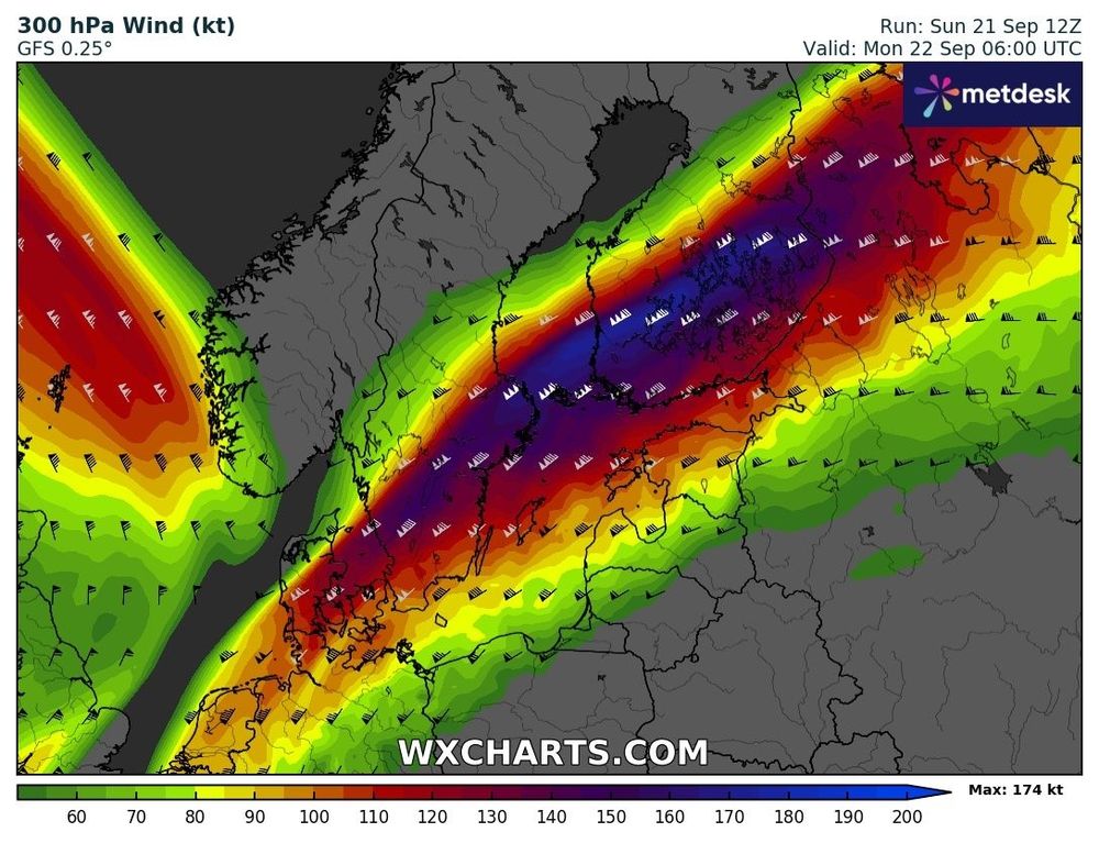
Windy day ahead tomorrow. One major factor is the powerful jet stream that facilitates cyclogenesis. Not so often we'll have 90 m/s wind speeds above us.
Forecast 300 hPa wind speeds from GFS model.