


Malcolm Meyer
@malcolmmeyer.com
🗺️ Freelance -geospatial- web developer ~ gardener ~ father ~ citizen ~ reggae - 'Hope without optimism.' 👨💻


December 16, 2025 at 3:24 PM
Reposted by Malcolm Meyer

Heard the one about how dozens of researchers assigned $144,000 worth of real world human tasks to the world’s “smartest” AIs to manage and…
They fucked up so monumentally that they were able to generate $1700 between them
arxiv.org/pdf/2510.26787
They fucked up so monumentally that they were able to generate $1700 between them
arxiv.org/pdf/2510.26787

December 2, 2025 at 9:04 AM
Heard the one about how dozens of researchers assigned $144,000 worth of real world human tasks to the world’s “smartest” AIs to manage and…
They fucked up so monumentally that they were able to generate $1700 between them
arxiv.org/pdf/2510.26787
They fucked up so monumentally that they were able to generate $1700 between them
arxiv.org/pdf/2510.26787
Retro css theme on perplexity AI rn 😂😂

November 20, 2025 at 10:56 AM
Retro css theme on perplexity AI rn 😂😂


lots of images coming in from Vantor and Capella for the #melissa #hurricane #disaster #disasterreposnse
www.mappingdisasters.com#6.05/20.662/...
www.mappingdisasters.com#6.05/20.662/...

Disaster Response Imagery
Open Satellite Imagery from Maxar, Capella, Umbra, and Wyvern.
www.mappingdisasters.com
November 5, 2025 at 3:40 PM
lots of images coming in from Vantor and Capella for the #melissa #hurricane #disaster #disasterreposnse
www.mappingdisasters.com#6.05/20.662/...
www.mappingdisasters.com#6.05/20.662/...
where is the open commercial satellite data for #melissa #Jamaica ? I mean maybe my script is broken 🤷 - we can only hope that's it #gis #opendata #disasters #disasterresponse
Maxar did release before imagery but nothing new yet...
Maxar did release before imagery but nothing new yet...

October 30, 2025 at 3:55 PM
where is the open commercial satellite data for #melissa #Jamaica ? I mean maybe my script is broken 🤷 - we can only hope that's it #gis #opendata #disasters #disasterresponse
Maxar did release before imagery but nothing new yet...
Maxar did release before imagery but nothing new yet...
Is it possible to have high quality printed maps from mapbox/maplibre...of course it is! If you want to get inspired for your next open source project, come check out my talk on Wednesday at #FOSS4GNA on one city's ongoing transition to an open source GIS solution.
#postgresql #webmaps #foss4g
#postgresql #webmaps #foss4g

October 30, 2025 at 3:18 PM
Is it possible to have high quality printed maps from mapbox/maplibre...of course it is! If you want to get inspired for your next open source project, come check out my talk on Wednesday at #FOSS4GNA on one city's ongoing transition to an open source GIS solution.
#postgresql #webmaps #foss4g
#postgresql #webmaps #foss4g


#duckdb and #deckgl have come a long way, amazing what can be done directly in the browser @developmentseed.org developmentseed.org/spatial-acce...

October 18, 2025 at 9:31 PM
#duckdb and #deckgl have come a long way, amazing what can be done directly in the browser @developmentseed.org developmentseed.org/spatial-acce...
this is how easily facts can be spun - using the term "deeply divided" when the percentages are 60/40 is a complete joke - "Americans are deeply divided on Donald Trump. A recent Reuters/Ipsos poll found that only 40% approved of his performance as president, while 58% disapproved." from the #bbc
October 18, 2025 at 8:29 PM
this is how easily facts can be spun - using the term "deeply divided" when the percentages are 60/40 is a complete joke - "Americans are deeply divided on Donald Trump. A recent Reuters/Ipsos poll found that only 40% approved of his performance as president, while 58% disapproved." from the #bbc
Ever since X became a dumpster fire and moving to bsky I still have not found that awesome feed that once scrolled across my phone in the prime days of twitter, beautiful maps and trending news...maybe I'm just not following the right people or social media or people's use of it has just changed 🤷
October 14, 2025 at 11:05 PM
Ever since X became a dumpster fire and moving to bsky I still have not found that awesome feed that once scrolled across my phone in the prime days of twitter, beautiful maps and trending news...maybe I'm just not following the right people or social media or people's use of it has just changed 🤷
Reposted by Malcolm Meyer

A lovely ocean tides map using the Spilhaus projection for some Wednesday mappy goodness #MapoftheWeek mapoftheweek.substack.com/p/a-world-of...

A World of Tides
The most recent issue of ArcUser, a magazine for Esri GIS software users spotlights cartographer Dave Taylor’s striking Oceanic Oscillations map.
mapoftheweek.substack.com
September 17, 2025 at 10:46 AM
A lovely ocean tides map using the Spilhaus projection for some Wednesday mappy goodness #MapoftheWeek mapoftheweek.substack.com/p/a-world-of...
Reposted by Malcolm Meyer

#trains #transport #datavis #datascience
chronotrains.com - great tool for estimating travel distance vs travel times
created by Benjamin Tran Dinh
tip by @forrest.nyc
chronotrains.com - great tool for estimating travel distance vs travel times
created by Benjamin Tran Dinh
tip by @forrest.nyc
September 18, 2025 at 10:41 AM
#trains #transport #datavis #datascience
chronotrains.com - great tool for estimating travel distance vs travel times
created by Benjamin Tran Dinh
tip by @forrest.nyc
chronotrains.com - great tool for estimating travel distance vs travel times
created by Benjamin Tran Dinh
tip by @forrest.nyc
Reposted by Malcolm Meyer
If you use #LinkedIn, you may want to access your settings here and opt out of having your data used to train their AI. This opt-in by default is ILLEGAL in the EU, but, you know, potatoes
This is the direct link to opt out
www.linkedin.com/mypreference...
This is the direct link to opt out
www.linkedin.com/mypreference...
LinkedIn Login, Sign in | LinkedIn
Login to LinkedIn to keep in touch with people you know, share ideas, and build your career.
www.linkedin.com
September 18, 2025 at 12:54 PM
If you use #LinkedIn, you may want to access your settings here and opt out of having your data used to train their AI. This opt-in by default is ILLEGAL in the EU, but, you know, potatoes
This is the direct link to opt out
www.linkedin.com/mypreference...
This is the direct link to opt out
www.linkedin.com/mypreference...

August 13, 2025 at 12:03 AM
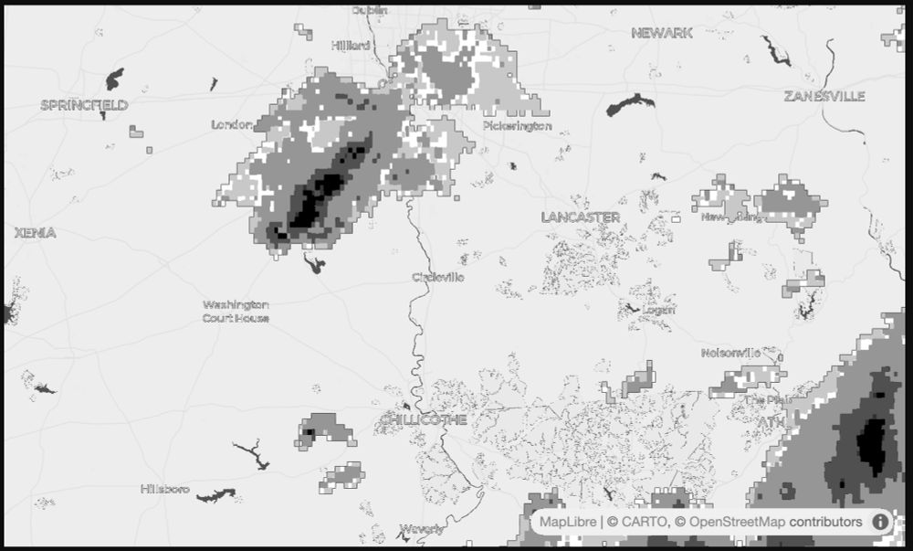
testing out my weather radar map-to-image for use in the TRMNL Image plugin - coming along nicely! @usetrmnl.com #nws #gis #maplibre
July 16, 2025 at 11:08 PM
testing out my weather radar map-to-image for use in the TRMNL Image plugin - coming along nicely! @usetrmnl.com #nws #gis #maplibre
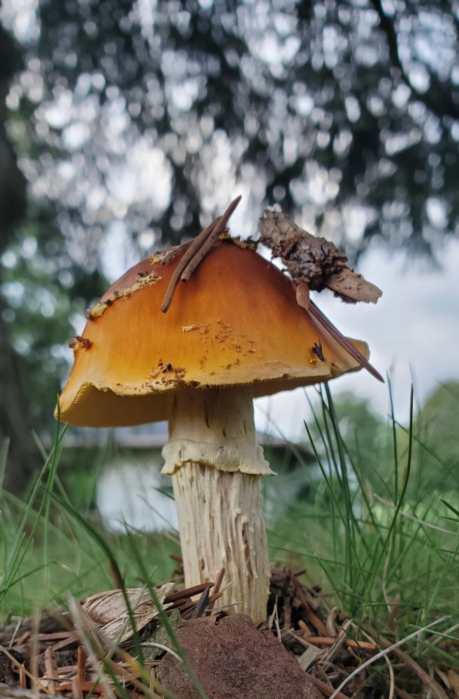
People on here seem to like mushrooms 🍄 so, here's a mushroom
June 16, 2025 at 11:02 PM
People on here seem to like mushrooms 🍄 so, here's a mushroom
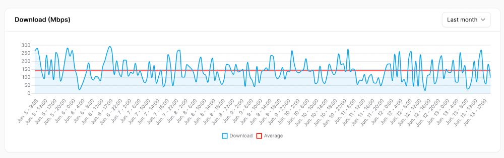
added speedtest tracker to my self-hosted server setup and now I see what you pay for 300 Mbps vs what your get 140 Mbps
#monopoly #Internet #digitaldivide
#monopoly #Internet #digitaldivide
June 14, 2025 at 12:31 AM
added speedtest tracker to my self-hosted server setup and now I see what you pay for 300 Mbps vs what your get 140 Mbps
#monopoly #Internet #digitaldivide
#monopoly #Internet #digitaldivide
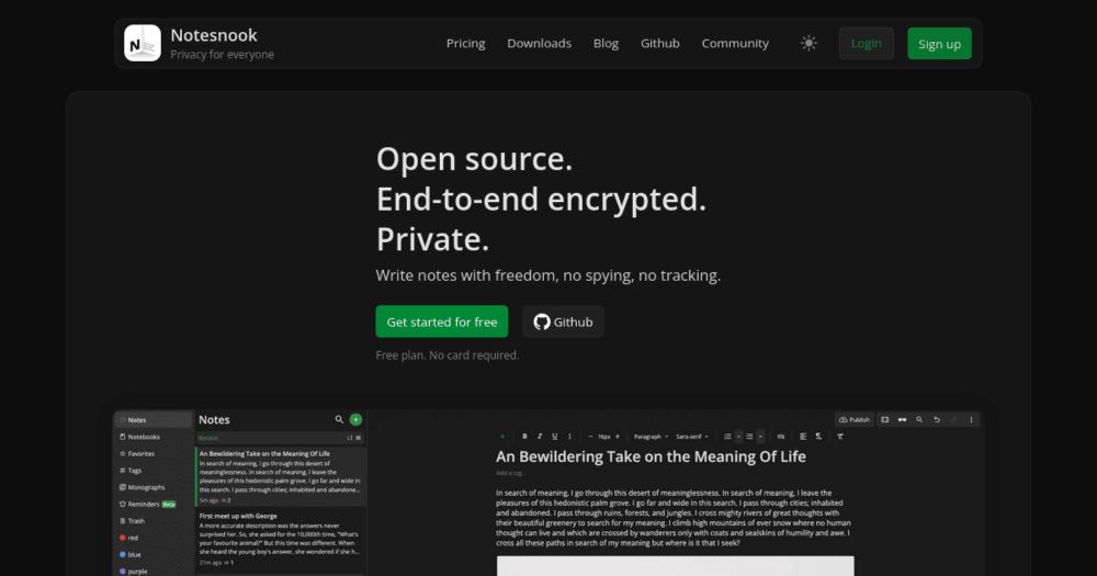
testing out yet another online notes editor [I've used Paper, Asana, Slack documents, DIY self-hosted, notepad, apple notes...] and actually loving it so far - I wish images were part of the free plan but still great interface and markdown editor -
#journaling #notes #todo #webdev
notesnook.com
#journaling #notes #todo #webdev
notesnook.com
Notesnook | Open source & zero knowledge private note taking app
Express yourself with freedom, no spying, no tracking — only private notes. Unlike Evernote and other note apps, your data is private — not open for everyone to see.
notesnook.com
June 4, 2025 at 12:47 PM
testing out yet another online notes editor [I've used Paper, Asana, Slack documents, DIY self-hosted, notepad, apple notes...] and actually loving it so far - I wish images were part of the free plan but still great interface and markdown editor -
#journaling #notes #todo #webdev
notesnook.com
#journaling #notes #todo #webdev
notesnook.com
May 23, 2025 at 7:03 PM